
SATURDAY WEATHER: Cold but mainly clear with more cold fronts arriving from Sunday
By Staff WriterPublished: 8 May 2026 [updated 9 May]
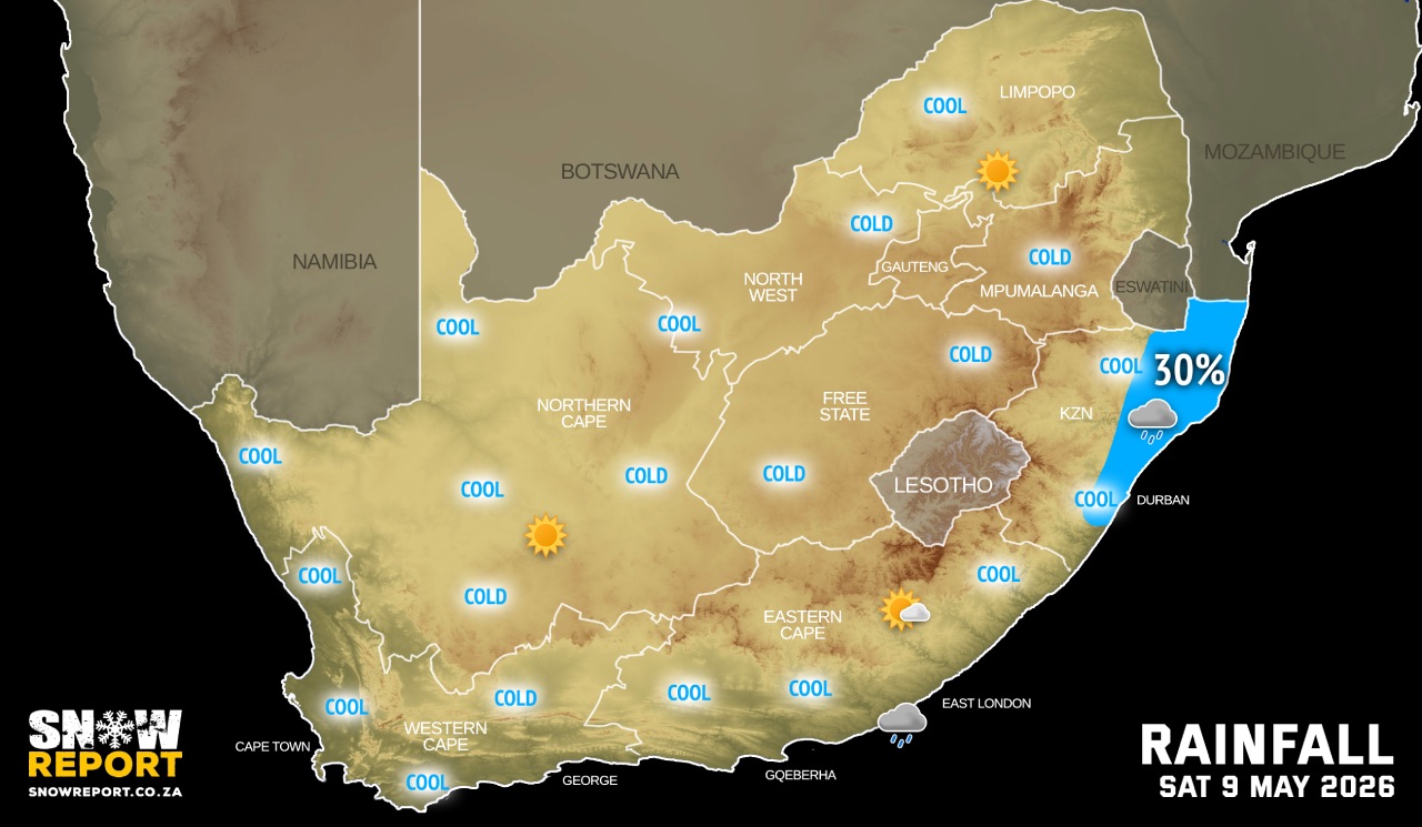
This forecast is for: Sat 09 May 2026
The maps cover: Sat 09 May – Sat 09 May
| SHARE TO |
The latest forecast is available by clicking here.
Very cold conditions are expected in places over Chris Hani and Joe Gqabi municipalities of the Eastern Cape on Saturday.
Two cold fronts are expected to affect the Western Cape from this weekend, with the first expected to make landfall on Sunday while a second and more powerful frontal system will impact the province on Monday according to the SA Weather Service.
SEE ALSO: Disruptive rainfall / snowfall, damaging winds & waves with flooding possible from Sunday and many warnings issued.
Warnings from the SA Weather Service for Saturday:
No warnings for now.
Regional forecasts from the SA Weather Service for Saturday:
GAUTENG
Morning frost in places, otherwise fine and cool to cold.
MPUMALANGA
Frost in places on the Highveld in the morning, otherwise fine and cool but warm in places in the Lowveld where it will be misty in places at first.
LIMPOPO
Frost in places in the south-western parts in the morning, otherwise fine and cool to warm.
NORTH WEST
Fine and cool.
THE FREE STATE
Morning fog in the extreme east, otherwise fine and cool but cold around Lesotho border.
THE NORTHERN CAPE
Morning fog in places, otherwise fine and cool to cold. The wind along the coast will be moderate to fresh southerly to southeasterly.
THE WESTERN CAPE
Morning fog in places in the north, otherwise fine and cool. The wind along the coast will be moderate southerly to south-westerly, but south-easterly along the south-west coast.
THE WESTERN HALF OF THE EASTERN CAPE
Morning fog in places in the west, otherwise fine and cool, but cold in places in the north. The wind along the coast will be moderate to fresh south-westerly.
THE EASTERN HALF OF THE EASTERN CAPE
Fine and cool, but cold in the north. The wind along the coast will be fresh to strong south-westerly.
KWAZULU-NATAL
Morning fog in places, otherwise partly cloudy and cool to warm but cold in the extreme south-west with isolated morning showers and rain along the coast and the north-east, except the extreme south coast. It will be fine in the west. The wind along the coast will be moderate to fresh south-westerly, but south-easterly in the north.
Travellers forecasts from the SA Weather Service for Saturday:
PRETORIA
Fine.
Minimum/Maximum: 6/21°C
JOHANNESBURG
Morning frost, otherwise fine.
Minimum/Maximum: 3/18°C
VEREENIGING
Morning frost, otherwise fine.
Minimum/Maximum: 3/19°C
MBOMBELA
Fine.
Minimum/Maximum: 9/25°C
POLOKWANE
Fine.
Minimum/Maximum: 6/22°C
MAHIKENG
Fine.
Minimum/Maximum: 6/20°C
VRYBURG
Fine.
Minimum/Maximum: 5/21°C
BLOEMFONTEIN
Fine.
Minimum/Maximum: 3/18°C
KIMBERLEY
Fine.
Minimum/Maximum: 5/19°C
UPINGTON
Fine.
Minimum/Maximum: 7/22°C
CAPE TOWN
Fine.
Wind: Moderate to fresh south-easterly.
Minimum/Maximum: 13/20°C
GEORGE
Fine.
Wind: Light to moderate south-westerly.
Minimum/Maximum: 10/20°C
GQEBERHA
Fine.
Wind: Moderate to fresh south-westerly.
Minimum/Maximum: 13/20°C
EAST LONDON
Fine.
Wind: Fresh to strong north-westerly.
Minimum/Maximum: 13/22°C
DURBAN
Partly cloudy with isolated morning showers and rain, becoming fine from mid-morning.
Wind: Moderate to fresh south-westerly.
Minimum/Maximum: 17/24°C
RICHARDS BAY
Morning fog, otherwise partly cloudy with isolated morning showers and rain. It will become fine from the afternoon.
Wind: Light to moderate south-easterly.
Minimum/Maximum: 16/25°C
PIETERMARITZBURG
Morning fog patches, otherwise partly cloudy.
Minimum/Maximum: 7/22°C
This forecast is usually updated a few times per day.
| SHARE TO |
Please be sure to send photos and videos to us via whatsapp and also tell us where and when they were taken.
Follow our channels