
SUNDAY WEATHER: Disruptive rainfall / snowfall, damaging winds & waves with flooding possible – many warnings issued
By Staff WriterPublished: 9 May 2026 [updated 10 May]
This forecast is for: Sun 10 May 2026
The maps cover: Sun 10 May – Sun 10 May
| SHARE TO |
The latest forecast is available by clicking here.
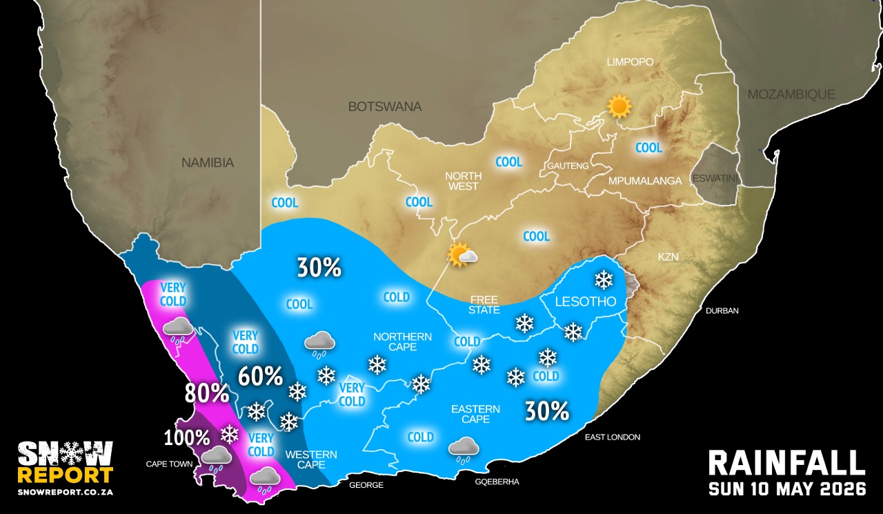
Two cold fronts are expected to affect the Western Cape from this weekend, with the first expected to make landfall on Sunday while a second and more powerful frontal system will impact the province on Monday according to the SA Weather Service.
These fronts are expected to result in disruptive rainfall and flooding impacts over the western parts of the Western Cape from Sunday until Tuesday, with three-day rainfall accumulations of 70-140mm likely.
A level 8 warning is in place along the escarpment where severe impacts are possible, particularly municipalities such as Drakenstein, Stellenbosch, City of Cape Town, the western parts of the Theewaterskloof, Breede Valley and Witzenberg local municipalities where 100-200mm is possible and 200-300mm may be possible in mountainous regions.
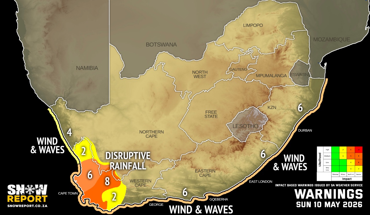
Damaging wave conditions expected along the coastal areas of the Western Cape province from Sunday until Tuesday. Wave heights of 4-6m are expected reaching 6.5-7.5m along the coast of the Western Cape, especially on Monday.
Showers and thundershowers are also likely to result in large amounts of small hail in places on Sunday.
See our SNOW FORECAST for the disruptive snowfall from Sunday.
Warnings from the SA Weather Service from Sunday:
A. level 8 warning for disruptive rainfall leading to flooding of roads, bridges and formal and informal settlements, mudslides and danger to life due to fast flowing rivers over the mountainous regions of the Drakenstein, Stellenbosch, the western parts of the Theewaterskloof, City of Cape Town, Breede Valley and Witzenberg local municipalities of the Western Cape until Tuesday.
B. level 6 warning for disruptive rainfall leading to flooding of roads, low-lying bridges, and formal as well as informal settlements over the southern West Coast and western parts of the Overberg Districts of the Western Cape until Tuesday.
C. level 6 warning for damaging winds and waves leading to danger to navigation at sea and damage to coastal infrastructure along the coast between Lambert's Bay and Cannon Rocks until Tuesday.
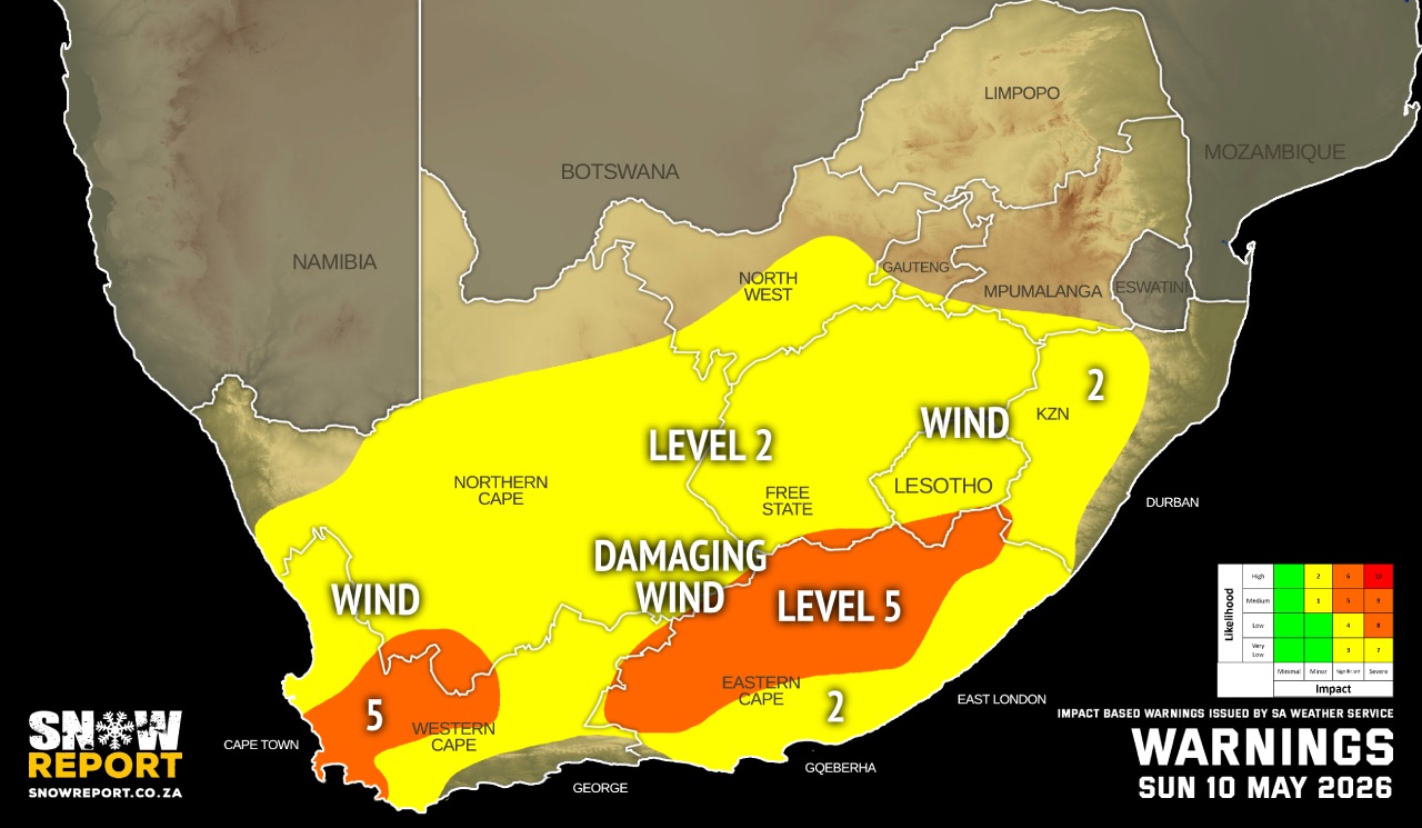
D. level 5 warning for damaging interior winds leading to damage of formal and informal settlements, power interruptions and closure of some routes due to falling trees over the central parts of the Western Cape and northern and central part of the Eastern Cape, but expected in the Western Cape until Tuesday.
E. level 4 warning for damaging winds and waves leading to danger to navigation at sea along the coast between Alexander Bay to Lambert's Bay until Tuesday.
F. level 2 warning disruptive rainfall leading to localised flooding of low-lying bridges, and formal as well as informal settlements over the northern parts of the West Coast, eastern parts of the Cape Winelands and Overberg Districts of the Western Cape until Tuesday.
G. level 2 warning for damaging winds leading to localised damage of informal settlements, falling trees and localised problems for high-sided vehicles on prone routes in places in the Western Cape, southern part of the Eastern Cape, interior of the KwaZulu-Natal, the Free State, the Northern Cape, parts of North West but expected in the Western Cape until Tuesday.
H. level 2 warning for disruptive snowfall leading to loss of vulnerable livestock, disruption of traffic due to icy roads and possible closure of mountain passes over the Karoo Hoogland municipality of the Northern Cape and in places over the Cape Winelands District of the Western Cape, as well as the northern part of the Eastern Cape until Monday.
Regional forecasts from the SA Weather Service for Sunday:
GAUTENG
Fine and cool to cold.
MPUMALANGA
Fine and cool to warm.
LIMPOPO
Fine and cool to warm.
NORTH-WEST
Fine, windy and cool
THE FREE STATE
Fine, windy and cool to cold, becoming partly cloudy in the afternoon with isolated showers and thundershowers in the south.
6.NORTHERN CAPE
Cloudy, windy and cold to cool with isolated showers and thundershowers but scattered in the western part.There is possible snow over the south. No rain is expected north-eastern parts. The wind along the coast will be fresh to strong west to north-westerly.
THE WESTERN CAPE
Cloudy, cold and windy with widespread rain and showers but isolated to scattered in the central and eastern parts. It will be very cold with snow over the south-western mountainous areas. The wind along the coast will be fresh to strong west to north-westerly becoming gale force along the south coast from the afternoon.
THE WESTERN HALF OF THE EASTERN CAPE
Cloudy, windy and cold with isolated showers of rain, but snowfalls can be expected over the interior high ground. The wind along the coast will be fresh to strong westerly to north-westerly.
THE EASTERN HALF OF THE EASTERN CAPE
Partly cloudy, windy and cold with isolated showers of rain, but snowfalls can be expected over the interior high ground. No precipitation is expected in the south-east. The wind along the coast will be moderate northerly at first, otherwise fresh to strong north-westerly.
KWAZULU-NATAL
Morning fog patches over the eastern interior, otherwise fine and cool to warm but hot in places in the eastern parts. The wind along the coast will be moderate north-westerly to northerly in the morning, otherwise fresh to strong northerly to north-easterly, becoming moderate to fresh south-westerly in the south by the evening.
Travellers forecasts from the SA Weather Service for Sunday:
PRETORIA
Fine.
Minimum/Maximum: 07/24°C
JOHANNESBURG
Fine.
Minimum/Maximum: 04/21°C
VEREENIGING
Fine.
Minimum/Maximum: 05/22°C
MBOMBELA
Fine.
Minimum/Maximum: 08/29°C
POLOKWANE
Fine.
Minimum/Maximum: 10/26°C
MAHIKENG
Fine and windy
Minimum/Maximum: 08/22°C
VRYBURG
Fine and windy
Minimum/Maximum: 07/19°C
BLOEMFONTEIN
Partly cloudy and windy
Minimum/Maximum: 06/18°C
KIMBERLEY
Partly cloudy and windy with isolated showers and thundershowers.
Minimum/Maximum: 07/18°C
UPINGTON
Cloudy and windy with isolated showers and thundershowers.
Minimum/Maximum: 10/15°C
CAPE TOWN
Cloudy, cold and windy with rain and showers.
Wind: Fresh to strong westerly.
Minimum/Maximum: 12/14°C
GEORGE
Cloudy with rain showers from the afternoon.
Wind: Moderate north-westerly becoming fresh to strong from the afternoon.
Minimum/Maximum: 12/15°C
GQEBERHA
Cloudy and windy with showers of rain.
Wind: Fresh to strong westerly to north-westerly.
Minimum/Maximum: 11/20°C
EAST LONDON
Partly cloudy, with afternoon showers of rain.
Wind: Moderate northerly at first, otherwise fresh to strong north-westerly.
Minimum/Maximum: 11/26°C
DURBAN
Fine.
Wind: Moderate north-westerly to northerly in the morning, otherwise fresh to strong northerly to north-easterly, becoming moderate to fresh south-westerly by the evening.
Minimum/Maximum: 16/33°C
RICHARDS BAY
Fine.
Wind: Moderate north-westerly to northerly in the morning, otherwise fresh to strong northerly to north-easterly.
Minimum/Maximum: 16/31°C
PIETERMARITZBURG
Morning fog patches, otherwise fine.
Minimum/Maximum: 07/29°C
This forecast is usually updated a few times per day.
| SHARE TO |
Please be sure to send photos and videos to us via whatsapp and also tell us where and when they were taken.
Follow our channels