
THURSDAY WEATHER: Level 8 rain, level 6 wind/waves and level 5 snow warnings
By Staff WriterPublished: 6 May 2026 [updated 7 May]
This forecast is for: Thu 07 May 2026
The maps cover: Thu 07 May – Thu 07 May
| SHARE TO |
The latest forecast is available by clicking here.
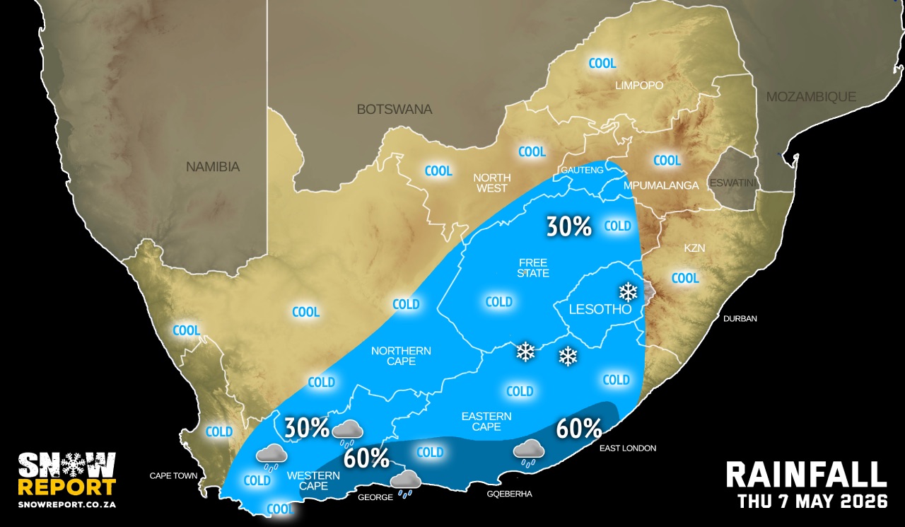
The intense cut-off low will continue to affect the country during the week, bringing a combination of snow, gale force winds, heavy rain, snow, flooding, very cold conditions and very rough seas.
SEE ALSO: Widespread and heavy snow for SA and Lesotho this week (5-7 May).
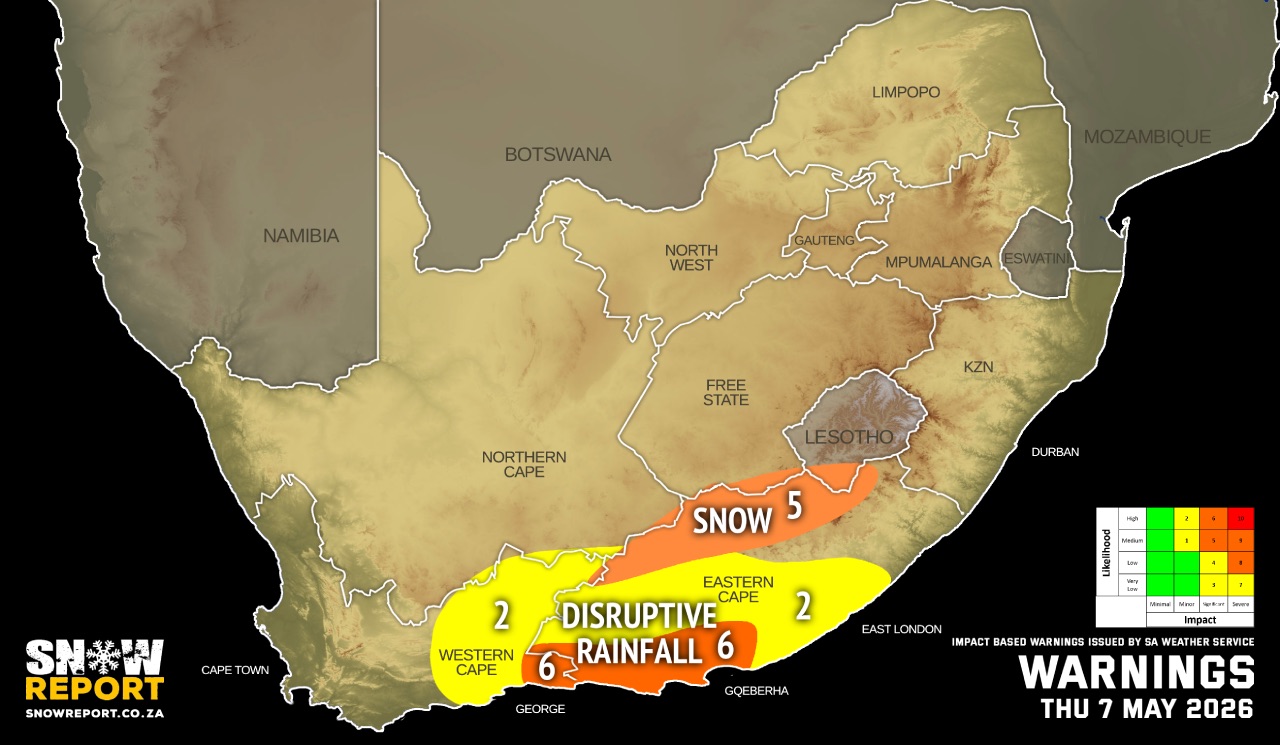
Warnings from the SA Weather Service for Thursday:
A. level 8 warning for disruptive rainfall leading to widespread flooding and prolonged disruptions of settlements, roads and bridges over Koukamma, Kouga Municipalities and Nelson Mandela Bay Metro of Eastern Cape.
B. level 6 warning for disruptive rainfall leading to flooding of settlements and property, roads, danger to life with some communities temporarily cut off over extreme eastern parts of the south of the Western Cape and western coast and adjacent interior of the Eastern Cape.
C. level 2 warning disruptive rainfall leading to localised flooding of susceptible settlements, roads and bridges as well as localised disruption due to sinkholes or blocked drainage systems over the eastern parts of the Western Cape, western parts and along the west coast of the Eastern Cape.
D. level 5 warning for disruptive snowfall leading to pass closures, communities temporarily cut-off and roads being affected due to accumulation of snow over Senqu, Elundini and Walter Sisulu Municipalities of the Eastern Cape.
E. level 2 warning for disruptive snowfall leading to loss of livestock and traffic disruptions over Br Beyers Naude, Walter Sisulu (Burgersdorp) and Chris Hani Municipalities of the Eastern Cape.
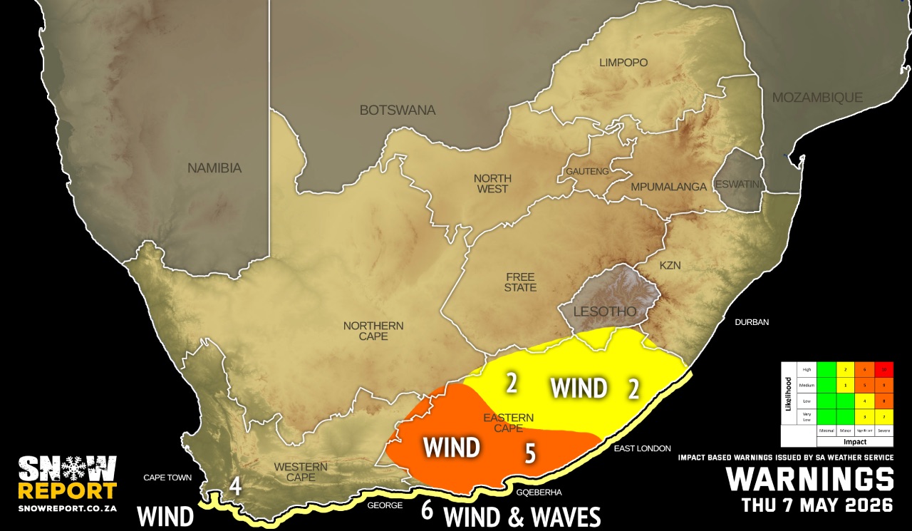
F. level 5 warning for damaging winds leading to damage to infrastructure, difficult driving conditions and disruption to power supply along the south coast and adjacent interior of the Eastern Cape.
G. level 2 warning for damaging winds leading to localised damage to settlements, infrastructure and travel disruptions over the vast parts of the Eastern Cape.
H. level 6 warning for damaging wind and waves leading to damage to coastal infrastructure, disruption of harbours, medium/large vessels dragging anchor/breaking mooring lines and disruptions to beachfront activities between Cape Agulhas and Port Edward.
I. level 4 warning for damaging wind and waves resulting in disruption of small harbours and ports between Cape Point and Cape Agulhas.
Regional forecasts from the SA Weather Service for Thursday:
GAUTENG
Partly cloudy and cool with isolated showers and rain in the south, where it will be cold.
MPUMALANGA
Fine in the Lowveld where it will be warm, otherwise partly cloudy and cool to cold.
LIMPOPO
Warm in the Lowveld, otherwise fine and cool but partly cloudy in the south-west.
NORTH-WEST
Partly cloudy to cloudy and cold, with isolated showers and rain in the extreme south.
THE FREE STATE
Cloudy and cold, with isolated showers and rain except in the extreme east.
THE NORTHERN CAPE
Partly cloudy to cloudy and cold to cool, with isolated showers and rain in the southern and south-eastern parts. The wind along the coast will be light to moderate southerly to south-easterly.
THE WESTERN CAPE
Cloud and cold to cool with isolated showers and rain over the southern and eastern parts, but scattered over the south-eastern parts. The wind along the coast will be moderate to fresh southerly to south-easterly, but south-westerly along the south coast.
THE WESTERN HALF OF THE EASTERN CAPE
Cloudy and cold to very cold with scattered showers, but widespread along the coast and adjacent interior. The wind along the coast will be strong to gale force southerly to south-westerly, moderating at night.
THE EASTERN HALF OF THE EASTERN CAPE
Cloudy and cold to very cold with scattered showers in the west, but isolated in the north-east. The wind along the coast will be fresh to strong westerly.
KWAZULU-NATAL
Fine and cool but warm in the extreme north-east. It will become partly cloudy in the afternoon. The wind along the coast will be moderate northerly to north-easterly, becoming moderate to fresh southerly to south-westerly south of Durban from mid-morning and spreading to Richards Bay in the evening.
Travellers forecasts from the SA Weather Service for Thursday:
PRETORIA
Partly cloudy.
Minimum/Maximum: 8/17°C
JOHANNESBURG
Partly cloudy with isolated showers and rain.
Minimum/Maximum: 7/14°C
VEREENIGING
Partly cloudy with isolated showers and rain.
Minimum/Maximum: 8/14°C
MBOMBELA
Partly cloudy.
Minimum/Maximum: 09/16°C
POLOKWANE
Fine.
Minimum/Maximum: 8/17°C
MAHIKENG
Cloudy.
Minimum/Maximum: 3/15°C
VRYBURG
Cloudy.
Minimum/Maximum: 4/15°C
BLOEMFONTEIN
Cloudy with isolated showers and rain.
Minimum/Maximum: 5/12°C
KIMBERLEY
Partly cloudy to cloudy with isolated showers and rain.
Minimum/Maximum: 5/12°C
UPINGTON
Partly cloudy to cloudy.
Minimum/Maximum: 7/16°C
CAPE TOWN
Partly cloudy.
Wind: Moderate southerly to south-easterly.
Minimum/Maximum: 14/19°C
GEORGE
Cloudy with scattered showers and rain.
Wind: Moderate to fresh south-westerly.
Minimum/Maximum: 12/16°C
GQEBERHA
Cloudy with widespread showers and rain.
Wind: Strong to gale force southerly to south-westerly.
Minimum/Maximum: 14/16°C
EAST LONDON
Cloudy with scattered showers and rain.
Wind: Strong to gale force westerly.
Minimum/Maximum: 14/18°C
DURBAN
Partly cloudy.
Wind: Moderate to fresh northerly to north-westerly, becoming southerly to south-westerly in the afternoon.
Minimum/Maximum: 18/25°C
RICHARDS BAY
Partly cloudy.
Wind: Moderate to fresh northerly to north-westerly, becoming southerly to south-westerly in the evening.
Minimum/Maximum: 15/26°C
PIETERMARITZBURG
Partly cloudy.
Minimum/Maximum: 8/24°C
This forecast is usually updated a few times per day.
| SHARE TO |
Please be sure to send photos and videos to us via whatsapp and also tell us where and when they were taken.
Follow our channels