
![Snow forecast map for 3 May 2026 [updated 5 May]](/img/SR-Map-5-May-2026-F3-cropped.jpg)
Widespread and heavy snow for SA and Lesotho – disruptive snowfall warnings issuedBy Staff WriterPublished: 3 May 2026 [updated 5 May] This forecast covers: Tue 05 May – Thu 07 May
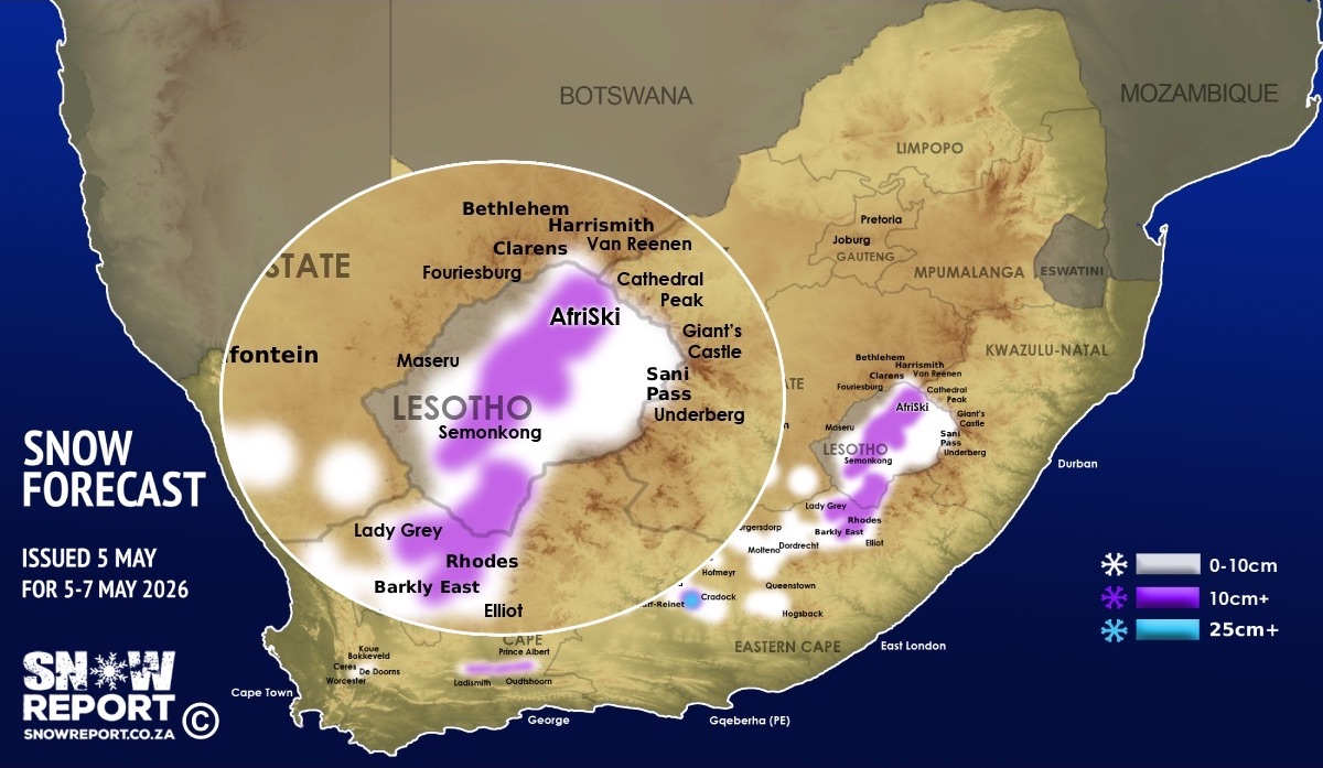
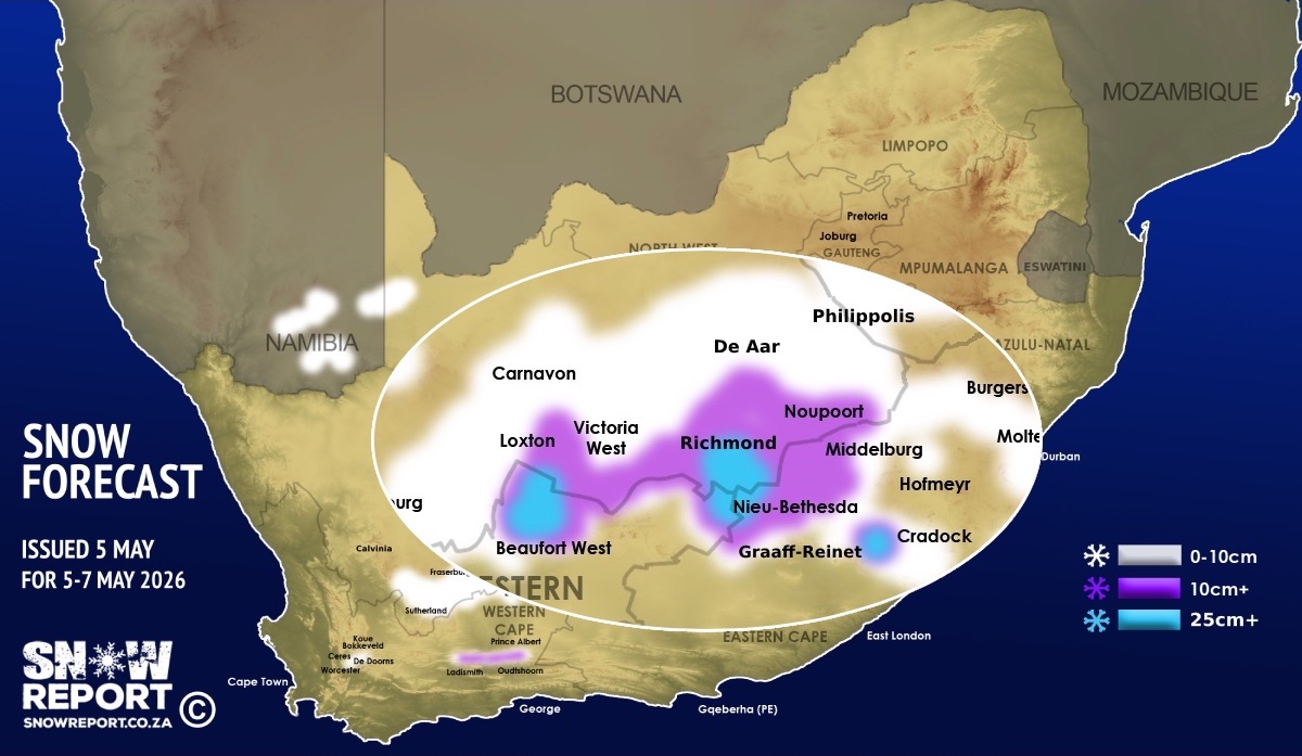
Snowfall is indicated across a number of South African provinces as well as Lesotho from Tuesday, through Wednesday and into Thursday this week with the heaviest snowfall mainly on Wednesday. Namibia is also back on the radar for snow, as per the map. An intense cut-off low-pressure system is expected to affect parts of the country from Tuesday to Thursday, bringing severe weather, strong winds, disruptive rainfall and flooding according to the SA Weather Service. Widespread rainfall is anticipated over the Western Cape and Eastern Cape, extending into the Free State, with 24-hour rainfall accumulations likely to exceed 100mm – 200mm in places. The weather service have also issued an advisory for disruptive snowfall over the Western Cape, Northern Cape and Eastern Cape. In South Africa the Western Cape, Northern Cape, Eastern Cape, Free State and the slopes of the Drakensberg in KwaZulu-Natal are currently on the radar for possible snow with the freezing level dropping to 2000m in some areas. A late night data update also indicated the possibility of light snowfall in the early hours of Wednesday morning in Gauteng with central Johannesburg, Soweto, Randfontein, Roodepoort, Alberton and Germiston appearing on the radar, as well as Delmas in Mpumalanga. The Lootsberg Pass on the N9 between Graaff-Reinet and Middelburg may get snow and could be closed, especially from Wednesday. Areas in South Africa where over 10cm of snow are possible on the high-ground or mountains are marked in purple on the map, and the hotspots are currently at higher elevations around Ladismith to De Rust (WC), Beaufort West, Loxton, Victoria West, Richmond, Murraysburg, Noupoort, Lady Grey, Rhodes. More than 25cm of snow is also indicated in a few areas in blue on the map above. Snow is also indicated for the high-ground or mountains around places like Ceres, De Doorns, Sutherland, Calvinia, Fraserburg, Carnavon, De Aar, Middelburg, Nieu-Bethesda, Graaff-Reinet, Cradock, Seymour, Queenstown, Molteno, Dordrecht, Barkly East, Khowa (Elliot) and Philippolis. The SA Weather Service (SAWS) has issued a level 2 warning for disruptive snowfall leading to icy and slippery roads, can be expected over the Karoo Hoogland of the Northern Cape and Beaufort West Municipality in the Western Cape as well as the high-lying areas of Joe Gqabi District Municipality in the Eastern Cape on Tuesday. SAWS has also issued a level 2 warning for disruptive snowfall leading to loss of livestock and traffic disruptions over the high-lying areas of northern and central parts of the Eastern Cape on Wednesday and Thursday. Most of the higher ground in Lesotho is indicated to receive anything from light snowfall to more than 10cm. Afriski and the top of Sani Pass are indicated to receive snowfall. Very strong wind is also indicated for the parts of the interior on Wednesday, when most of the snow is expected, and this will result in a significant wind chill effect. Farmers with livestock at higher elevations and those expecting to be hiking in the mountains might want to monitor our updates regularly. This forecast may change as the event unfolds, so check our website or social media for updates regularly, althought it has been fairly constantly for a few days. See below more maps with zoomed in regional sections. ALSO READ: Be prepared for safe winter travel and snow chasing trips. SEE ALSO: Snow fell in the Western Cape in April as expected. Click here for photos. The map indicates where we are seeing the possibility of snow, but it may not fall in all of the areas shown on the map. As with any forecast of any kind (temperature, clouds, rain, wind), what eventually happens may or may not be similar to the forecast. Snow indicated may reduce or vanish completely in some areas, or the dates and times may change. Follow our channels
Standard users are welcome to use the standard sharing buttons on this page to share our content. It is NOT acceptable to download or screen grab for reposting. Other media and channels need to send us a request in order to embed or use of our forecasts, maps, as well as images and video from our users that we post (before doing so).
|