
WEDNESDAY WEATHER: Disruptive rain, major snow, big waves, gale-force winds and flooding - ten warnings issued
By Staff WriterPublished: 5 May 2026
This forecast is for: Wed 06 May 2026
The maps cover: Wed 06 May – Wed 06 May
| SHARE TO |
The latest forecast is available by clicking here.
An intense cut-off low is expected to affect the Eastern Cape and the eastern parts of the Western Cape from Tuesday until Thursday.
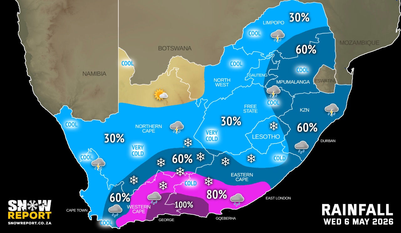
Very cold, windy and wet conditions are expected over Free State, North West and the Northern Cape. These conditions will remain along the Lesotho border and the southern parts of the Northern Cape on Thursday.
Widespread rainfall is anticipated over the Western Cape and Eastern Cape, extending into the Free State, with 24-hour rainfall accumulations likely to exceed 100mm – 200mm in places.
SEE ALSO: Widespread and heavy snow for SA and Lesotho this week (5-7 May).
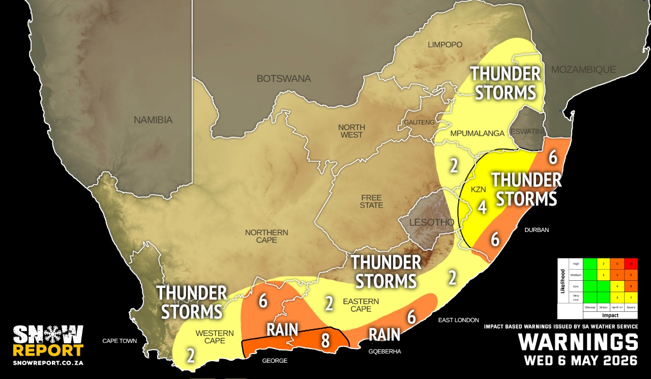
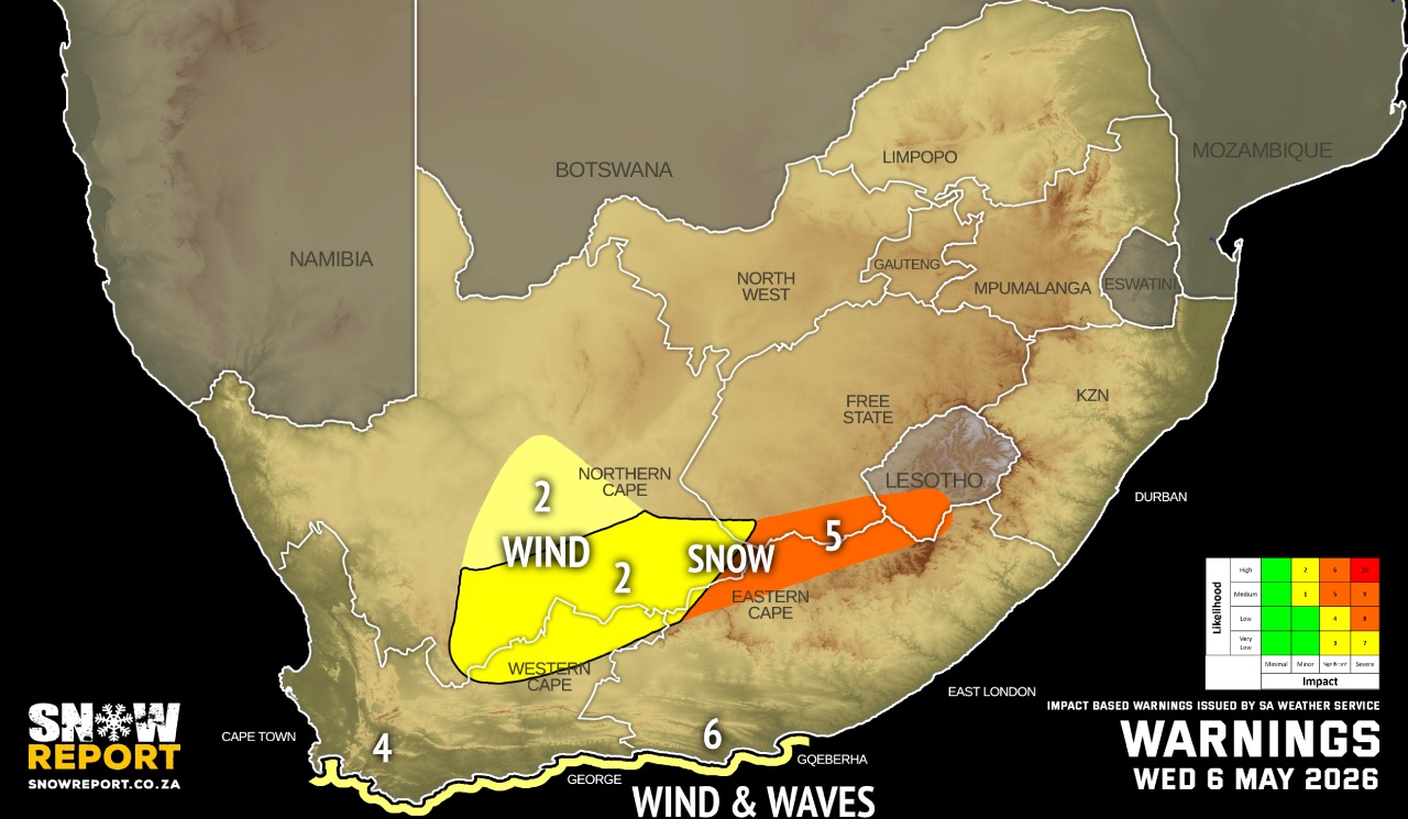
Warnings from the SA Weather Service from Wednesday:
Note the warning maps will be updated again shortly to reflect the late changes.
A. level 8 warning for disruptive rainfall resulting in widespread flooding of settlements/property, roads, and danger to life with some communities temporarily cut off as well as widespread transport routes and travel services severely affected over the Koukamma and Kouga Local Municipalities of the Eastern Cape as well as the Garden Route of the Western Cape on Wednesday into Thursday.
B. level 6 warning for disruptive rainfall leading to flooding of roads and settlements over the Central Karoo, Kannaland and Hessequa Municipalities of the Western Cape on Wednesday into Thursday (06-07/05/2026) as well as Nelson Mandela Bay Metro, Buffalo City Metro, Dr Beyers Naude, Blue Crane Route, Ndlambe, Ngquuswa, Great Kei, Mnquma, Mbhashe, King Sabatha Dalindyebo, Nyandeni, Port St Johns, Winnie Madikizela-Mandela and Mbizana Local Municipalities of the Eastern Cape.
C. level 6 warning for severe thunderstorms associated with heavy downpours resulting in flooding of roads, settlements, as well as large amounts of small hail over a populated area over the eastern parts of KwaZulu-Natal.
D. level 4 warning for severe thunderstorms accompanied by strong damaging winds, hail and heavy downpours resulting in flooding of roads and settlements as well as damage to infrastructure over the western and interior of KwaZulu-Natal.
E. level 2 warning severe thunderstorms accompanied by heavy downpours, strong damaging winds resulting in localised flooding of roads and settlements over Mpumalanga, central and south-eastern parts of the Eastern Cape and central parts of the Western Cape.
F. level 5 warning for disruptive snowfall leading to pass closures, communities temporarily cut-off and icy and slippery roads over the northern parts of the Eastern Cape and Western Cape as well the southern parts of the Northern Cape.
G. level 2 warning for damaging interior winds leading to damage to settlements (formal and informal) as well as disruptions to road and rail transport over the southern parts of the Northern Cape and the extreme north-eastern parts of the Western Cape as well as the central interior of KwaZulu-Natal.
H. level 2 warning for disruptive snowfall leading to possible loss of live stock and crops, as well as traffic disruptions due to icy roads and railway lines.
I. level 6 warning for damaging wind and waves leading to damage to coastal infrastructure, disruption of harbours, medium/large vessels dragging anchor/breaking mooring lines and disruptions to beachfront activities along the coast between Cape Agulhas and Cannon Rocks.
J. level 4 warning for damaging wind and waves damaging wind and waves resulting in disruption of small harbours and ports between Cape Point and Cape Agulhas on Wednesday and Thursday.
Regional forecasts from the SA Weather Service for Wednesday:
GAUTENG
Partly cloudy and cool with isolated showers and thundershowers but scattered over the extreme eastern parts.
MPUMALANGA
Partly cloudy and cold to cool with scattered morning showers and thundershowers, but warm in the Lowveld.
LIMPOPO
Partly cloudy and cool to warm with isolated to scattered morning showers and thundershowers.
NORTH-WEST
Partly cloudy to cloudy, windy and cold , with isolated showers and thundershowers, except over the north-western parts.
THE FREE STATE
Cloudy, windy and very cold to cold, with isolated showers and thundershowers, but scattered along the Lesotho border and the eastern parts.
THE NORTHERN CAPE
Cloudy, windy and very cold to cold, with isolated showers and thundershowers except over northern but scattered in the south, where it will be very cold with snowfalls over the southern high-ground. The wind along the coast will be moderate southerly to south-easterly, becoming moderate south-westerly in the afternoon.
THE WESTERN CAPE
Morning fog patches over the western parts, otherwise cloudy and cool to cold with isolated showers and rain but scattered to widespread over the central and eastern parts where it will be windy. Snowfalls can be expected over the north-eastern high-ground where it will be very cold. Wind along the coast: moderate to fresh southerly to south-easterly but strong to gale force in places along the south coast.
THE WESTERN HALF OF THE EASTERN CAPE
Cloudy, windy and cold with widespread showers and thundershowers, but general along the coast and adjacent interior. It will be very cold with snowfall over the northern high ground. The wind along the coast will be strong to gale force south-easterly early morning and from late afternoon, otherwise light and variable.
THE EASTERN HALF OF THE EASTERN CAPE
Partly cloudy and cool with isolated showers and thundershowers along the wild coast and adjacent interior, otherwise cloudy and cold with scattered showers and thundershowers, but widespread in the south-west. It will be very cold and windy with snowfall north of the escarpment. The wind along the coast will be fresh to strong north-westerly, becoming south-westerly from late morning.
KWAZULU-NATAL
Cloudy with scattered showers and thundershowers in the morning, otherwise partly cloudy and cold to cool. The wind along the coast will be moderate westerly to north-westerly in the morning, otherwise moderate to fresh northerly to north-easterly. It will become moderate to fresh southerly to south-westerly south of Durban in the evening.
Travellers forecasts from the SA Weather Service for Wednesday:
PRETORIA
Partly cloudy with isolated showers and thundershowers.
Minimum/Maximum: 11/16°C
JOHANNESBURG
Partly cloudy with isolated showers and thundershowers.
Minimum/Maximum: 8/14°C
VEREENIGING
Partly cloudy with isolated showers and thundershowers.
Minimum/Maximum: 7/14°C
MBOMBELA
Partly cloudy with scattered morning showers and thundershowers.
Minimum/Maximum: 16/25°C
POLOKWANE
Partly cloudy with isolated morning showers and thundershowers.
Minimum/Maximum: 12/19°C
MAHIKENG
Cloudy, windy with isolated showers and thundershowers.
Minimum/Maximum: 3/14°C
VRYBURG
Cloudy, windy with isolated showers and thundershowers.
Minimum/Maximum: 1/12°C
BLOEMFONTEIN
Cloudy, windy with isolated showers and thundershowers.
Minimum/Maximum: 3/10°C
KIMBERLEY
Cloudy, windy with isolated showers and thundershowers.
Minimum/Maximum: 3/10°C
UPINGTON
Cloudy and windy with isolated showers and thundershowers.
Minimum/Maximum: 4/14°C
CAPE TOWN
Early morning fog patches, otherwise cloudy with isolated showers, becoming partly cloudy from late afternoon.
Wind: Light and variable, becoming moderate to fresh southerly to south-easterly.
Minimum/Maximum: 12/19°C
GEORGE
Cloudy with widespread showers and rain (100% chance). Heavy rain is expected.
Wind: Strong to near gale force southerly to south-easterly, moderating from late afternoon.
Minimum/Maximum: 12/16°C
GQEBERHA
Cloudy with general showers and thundershowers (100% chance).
Wind: Strong to gale force south-easterly early morning and from late afternoon, otherwise light and variable.
Minimum/Maximum: 14/17°C
EAST LONDON
Cloudy with widespread showers and thundershowers, becoming party cloudy in the afternoon.
Wind: Moderate to fresh north-westerly, becoming fresh to strong south-westerly from late morning.
Minimum/Maximum: 15/19°C
DURBAN
Cloudy with scattered showers and thundershowers, becoming partly cloudy from late morning.
Wind: Moderate to fresh northerly to north-westerly, becoming southerly to south-westerly in the evening.
Minimum/Maximum: 18/26°C
RICHARDS BAY
Cloudy with scattered showers and thundershowers, becoming partly cloudy in the afternoon.
Wind: Moderate to fresh northerly to north-westerly.
Minimum/Maximum: 19/26°C
PIETERMARITZBURG
Cloudy with scattered showers and thundershowers, becoming partly cloudy from late morning.
Minimum/Maximum: 10/22°C
This forecast is usually updated a few times per day.
| SHARE TO |
Please be sure to send photos and videos to us via whatsapp and also tell us where and when they were taken.
Follow our channels