
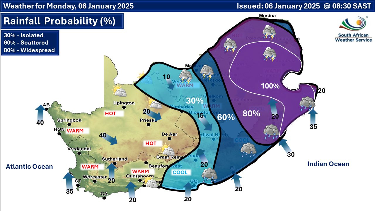
 Rainfall probability. More maps below the forecast
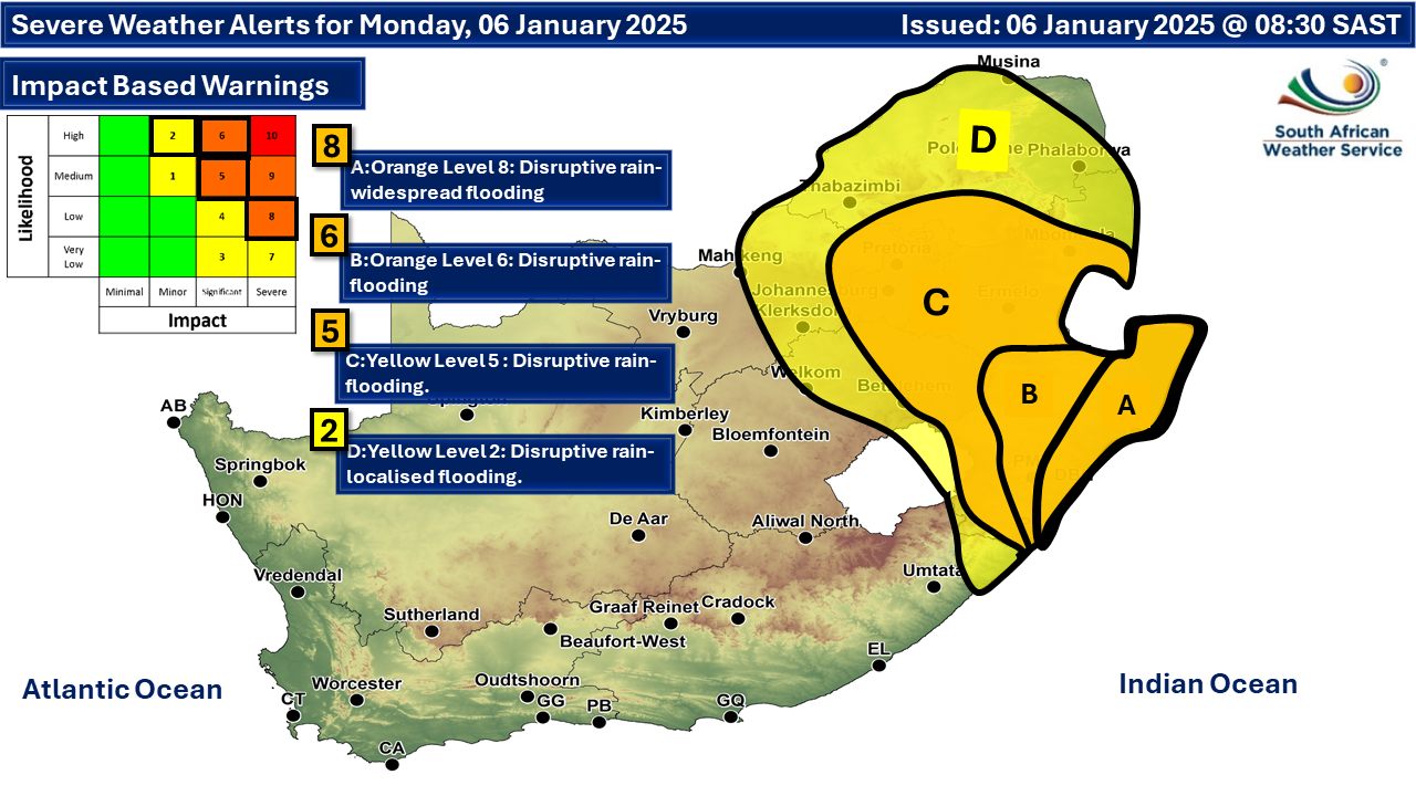
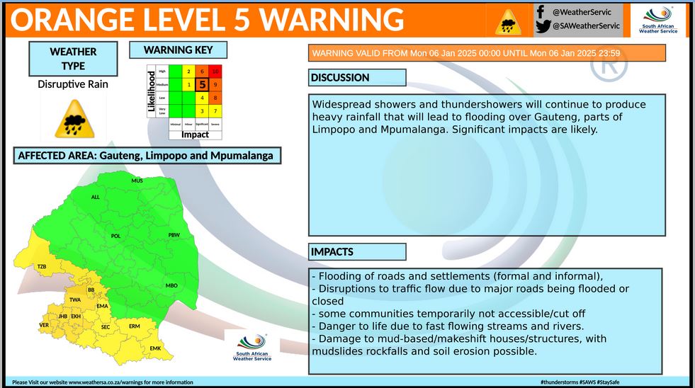
Three orange level disruptive rainfall warnings on Monday with flooding possible5 January 2025 [updated 6 January]By Staff Writer
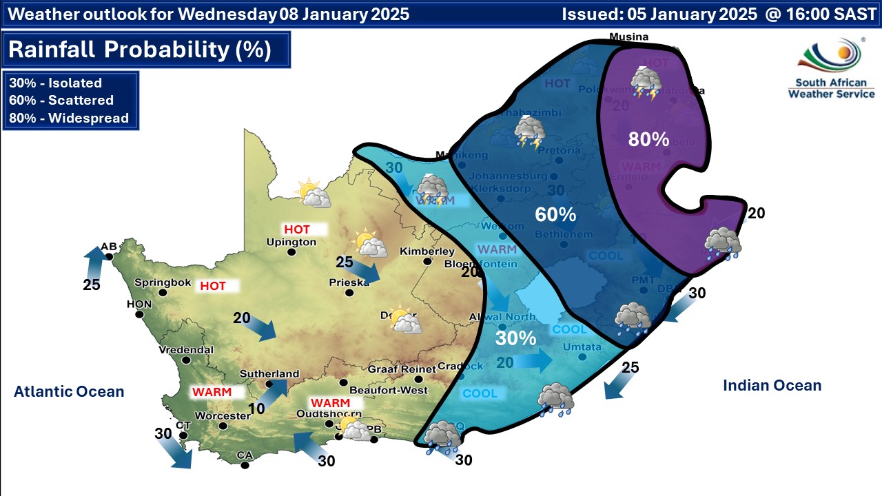
A newer forecast is available by clicking here but the various warnings for Monday may still apply. Showers and thundershowers are expected to be confined to the central and eastern parts of the country, with disruptive rain that will lead to possible flooding in some areas, according to the SA Weather Service (SAWS). Rainfall accumulation in excess of 150mm is expected within 24 hour period in places along the coast and adjacent interior of KwaZulu-Natal on Monday and severe impacts can be expected. Cool to warm temperatures over most parts of the country on Monday, but it will be hot in places in the Northern Cape, the Western Cape and Limpopo. ALSO READ: Heavy disruptive rainfall expected to be a threat at the end of the festive season. On Tuesday and Wednesday scattered to widespread showers and thundershowers are expected over the eastern areas of the country. Otherwise, fine and warm to hot. Warnings from the SA Weather Service for Monday: A. orange level 8 warning for disruptive rainfall leading widespread flooding of roads and settlements, danger to life (fast flowing streams / deep water, widespread damage to property, buildings and loss of livelihoods and livestock, major roads and bridges damaged or washed away and disruption to municipal services, such as water and electricity, are expected in places along the coast of KwaZulu-Natal. B. orange level 6 warning for disruptive rainfall leading to flooding of roads, settlements, damage to infrastructure, displacement of affected communities, major disruption of traffic flow due to major roads being flooded and mud-based houses washed away, is expected over most parts of KwaZulu-Natal, except in the south-west. C. orange level 5 warning for disruptive rainfall resulting in flooding of roads and settlements (formal and informal), danger to life (fast flowing streams /deep water), damage to property, infrastructure, loss of livelihood and livestock, and major disruption of traffic flow due to major roads being flooded or closed, is expected over Gauteng, south-central parts of Limpopo, the Highveld and escarpment of Mpumalanga, the north-eastern parts of Free State, and the south-western parts of KwaZulu-Natal. D. yellow level 2 warning for disruptive rainfall leading to localised flooding and localised damages to infrastructure and low-lying areas and bridges, is expected over the eastern parts of both Free State and North West, extreme south-eastern parts of the Eastern Cape, north-eastern parts of Mpumalanga, as well as parts of Limpopo, excluding the south-central and extreme north-east. Extremely high fire danger conditions are expected over Kareeberg Local Municipality in the Northern Cape. Regional forecasts from SAWS for Monday: 1. GAUTENG Cloudy and warm with on and off showers and thundershowers. The expected UVB sunburn index: Low 2. MPUMALANGA Morning fog along the escarpment, otherwise cloudy and cool to warm with on and off showers and thundershowers. It will be hot in the Lowveld. 3. LIMPOPO Morning fog along the escarpment, otherwise cloudy and warm to hot with widespread showers and thundershowers but scattered in the extreme north-east. 4. NORTH WEST Cloudy and warm, with scattered to widespread showers and thundershowers. 5. FREE STATE Cloudy and cool to warm with isolated to scattered showers and thundershowers, but widespread in the east. No rainfall is expected in the extreme west. 6. NORTHERN CAPE Cool in places along the coast, otherwise partly cloudy and warm to hot with isolated showers and thundershowers in the extreme north-east. It will becoming fine in the west by the afternoon. The wind along the coast will be fresh to strong southerly to south-easterly. 7. WESTERN CAPE Cloudy in the east in the morning, otherwise partly cloudy and cool to warm but fine in the western interior where it will be hot in places. The wind along the coast will be light to moderate south-westerly in the south in the morning, where it will become light and variable in the evening, otherwise fresh to strong southerly. The expected UVB sunburn index: Extreme 8. WESTERN HALF OF THE EASTERN CAPE Partly cloudy and warm with isolated light showers in places. A chance of light rain is possible along the coast, mainly in the morning. The wind along the coast will be moderate south-westerly, becoming light south-easterly in the evening. 9. EASTERN HALF OF THE EASTERN CAPE Cloudy and cool to warm with scattered showers and rain but isolated in the north-west. The wind along the coast will be moderate south-westerly becoming light south-easterly in the evening. 10. KWAZULU-NATAL Warm in the north-east, otherwise cloudy and cool with on and off showers and thundershowers. The wind along the coast will be moderate to fresh southerly to south-westerly. The expected UVB sunburn index: Low Travellers forecasts from SAWS for Monday: PRETORIA Cloudy with on and off showers and thundershowers. Minimum/Maximum: 20/26°C The expected UVB Sunburn Index: Low JOHANNESBURG Cloudy with on and off showers and thundershowers. Minimum/Maximum: 19/24°C VEREENIGING Cloudy with on and off showers and thundershowers. Minimum/Maximum: 20/25°C MBOMBELA Cloudy with widespread showers and thundershowers. Minimum/Maximum: 20/27°C POLOKWANE Cloudy with widespread showers and thundershowers. Minimum/Maximum: 20/26°C MAHIKENG Cloudy with widespread showers and thundershowers. Minimum/Maximum: 19/25°C VRYBURG Cloudy with scattered showers and thundershowers. Minimum/Maximum: 19/27°C BLOEMFONTEIN Cloudy with isolated showers and thundershowers. Minimum/Maximum: 18/27°C KIMBERLEY Cloudy at first, becoming partly cloudy. Minimum/Maximum: 19/31°C UPINGTON Partly cloudy becoming fine. Minimum/Maximum: 17/33°C CAPE TOWN Fine. Wind: Moderate southerly, becoming fresh to strong from the afternoon. Minimum/Maximum: 16/24°C The expected UVB Sunburn Index: Extreme GEORGE Cloudy at first, otherwise partly cloudy. Wind: Light westerly to south-westerly, becoming light to moderate southerly from the afternoon but light and variable from the evening. Minimum/Maximum: 15/22°C GQEBERHA Partly cloudy with scattered showers and rain in the morning. Wind: Moderate south-westerly becoming light south-easterly in the evening. Minimum/Maximum: 19/24°C EAST LONDON Cloudy with scattered showers and rain. Wind: Moderate south-westerly becoming light south-easterly in the evening. Minimum/Maximum: 19/22°C DURBAN Cloudy with showers and thundershowers. Wind: Moderate to fresh southerly to south-westerly. Minimum/Maximum: 22/25°C The expected UVB Sunburn Index: Low RICHARDS BAY Cloudy with showers and thundershowers. Wind: Moderate to fresh southerly to south-westerly. Minimum/Maximum: 23/26°C PIETERMARITZBURG Cloudy with widespread showers and thundershowers. Minimum/Maximum: 18/22°C This forecast is usually updated a few times per day.
Please be sure to send photos and videos to us via whatsapp and also tell us where and when they were taken. Follow our channels
Issued on Monday
 Issued on Sunday
  Issued on Saturday
|