
SEVERE WEATHER: Intense cut-off low – disruptive rain, heavy snow, big waves, gale-force winds and LEVEL 8 flooding
By Staff WriterPublished: 4 May 2026 [updated 5 May]
This forecast is for: Tue 05 May 2026
The maps cover: Tue 05 May – Tue 05 May
| SHARE TO |
The latest forecast is available by clicking here.
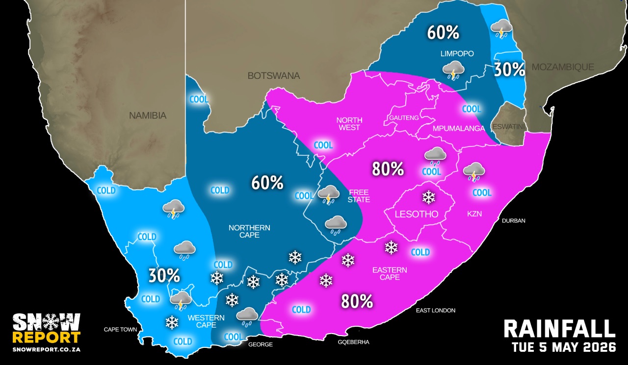
An intense cut-off low is expected to affect the Eastern Cape and the eastern parts of the Western Cape from Tuesday evening until Thursday. Adverse weather conditions are expected, including disruptive rainfall, strong interior winds and gale-force coastal winds, damaging waves, storm surge, and disruptive snowfall in places over the high-lying areas.
The system is expected to initially affect the Western Cape, Northern Cape, and Eastern Cape before spreading eastward across the central and eastern interior from Tuesday afternoon into Wednesday morning.
Isolated to scattered showers and thundershowers are expected over the central and western interior on Monday, with scattered thundershowers likely over the Free State, Northern Cape, western parts of North West, as well as parts of the Eastern Cape and the western regions of the Western Cape.
Rainfall is expected to become more widespread along the south-west coast. There is a high likelihood of severe thunderstorms developing over the interior and the eastern parts of the Eastern Cape from the afternoon onwards. These storms may result in heavy downpours leading to localised flooding, as well as damaging winds, hail, and excessive lightning.
Significant weather-related impacts are expected along parts of the Eastern Cape coastline and the adjacent interior on Tuesday and Wednesday, as well as over the eastern parts of the Western Cape from Tuesday afternoon through to Thursday.
Widespread rainfall is anticipated over the Western Cape and Eastern Cape, extending into the Free State, with 24-hour rainfall accumulations likely to exceed 100mm – 200mm in places.
SEE ALSO: Widespread snow expected for South Africa and Lesotho this week (5-7 May).
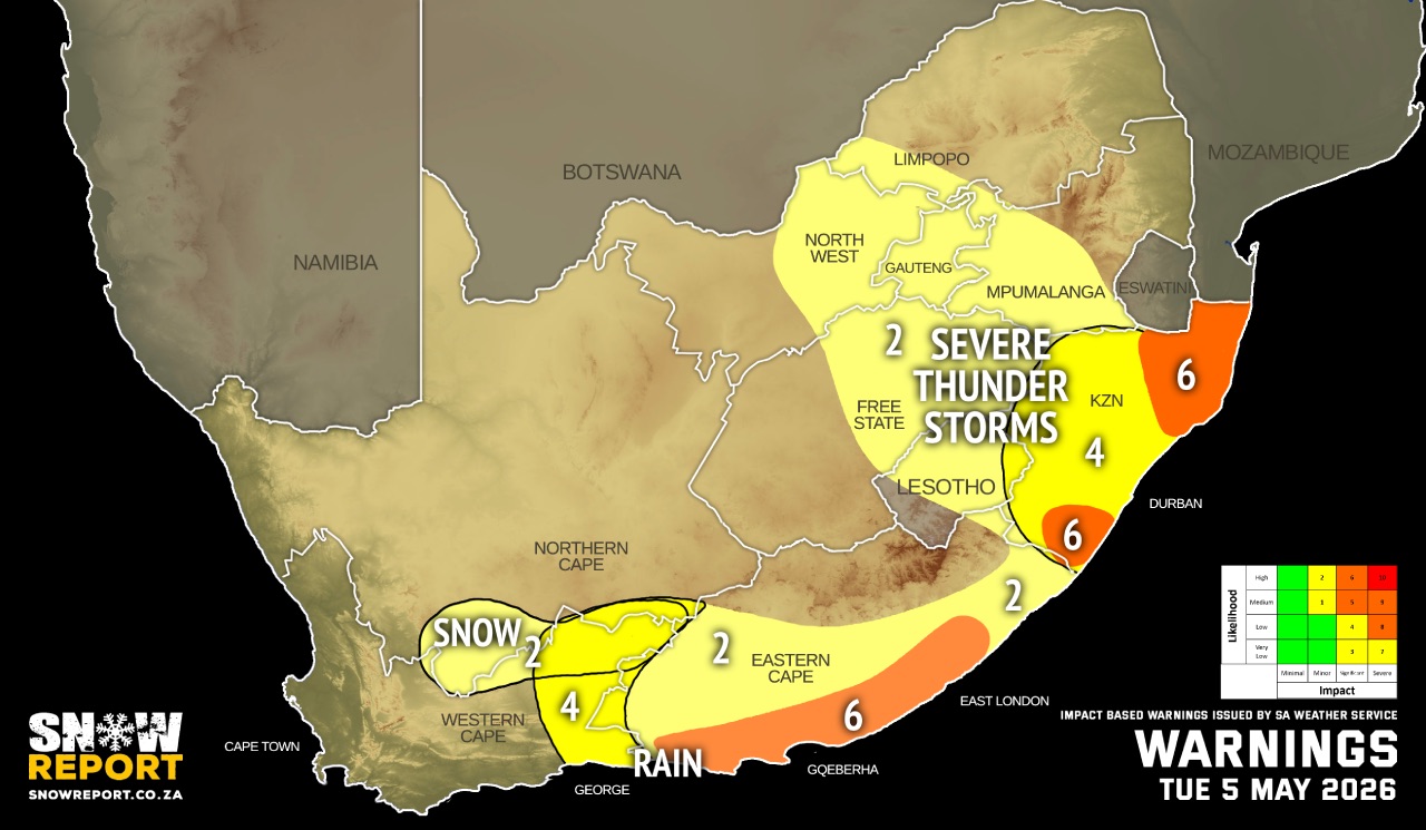
Warnings from the SA Weather Service from Tuesday:
A. level 8 warning for disruptive rainfall leading to flooding of settlements/property, roads, danger to life with some communities temporarily cut off is expected in places over Koukamma and Kouga Local Municipalities in the Eastern Cape. This warning was added on Tuesday morning and is not marked on the map above.
B. level 6 warning for disruptive rainfall leading to flooding of settlements/property, roads, danger to life with some communities temporarily cut off is expected in places along the coast between Tsitsikamma and Kei Mouth in the Eastern Cape persisting into Thursday.
C. level 6 warning for severe thunderstorms accompanied by strong damaging winds, hail and heavy downpours resulting in flooding of roads and settlements as well as damage to infrastructure are expected over the north-eastern and south-eastern parts of KwaZulu-Natal.
D. level 4 warning for severe thunderstorms accompanied by strong damaging winds, hail and heavy downpours resulting in flooding of roads and settlements as well as damage to infrastructure are expected over most parts of KwaZulu-Natal.
E. level 4 warning for disruptive rainfall resulting in disruption to essential services and localised flooding can be expected over the Central Karoo and eastern parts of the Garden Route of the Western Cape.
F. level 2 warning for severe thunderstorms leading to localised flooding of susceptible roads, low-lying areas and bridges, as well as localised damage to damage to settlements over an open area are expected over Gauteng, the eastern and central parts of both North West and Free State, Mpumalanga Highveld, Western Bushveld in Limpopo and most parts of the Eastern Cape except in the north-eastern parts.
G. level 2 warning for disruptive snowfall leading to icy and slippery roads, can be expected over the Karoo Hoogland of the Northern Cape and Beaufort West Municipality in the Western Cape as well as the high-lying areas of Joe Gqabi District Municipality in the Eastern Cape.
Regional forecasts from the SA Weather Service for Tuesday:
GAUTENG
Cloudy and cool with widespread showers and thundershowers.
MPUMALANGA
Partly cloudy with isolated showers and thundershowers in the Lowveld, where it will be how in places otherwise cloudy and warm with scattered to widespread showers and thundershowers.
LIMPOPO
Partly cloudy and hot with isolated showers and thundershowers over the Lowveld, otherwise cloudy and warm with scattered showers and thundershowers.
NORTH-WEST
Partly cloudy and cool, becoming cloudy with widespread showers and thundershowers.
THE FREE STATE
Cloudy and cool, with widespread showers and thundershowers but scattered in the extreme west.
6. EASTERN PARTS OF THE NORTHERN CAPE
Cloudy and cold to cool, with isolated showers and thundershowers but scattered in the east and central. Light snowfalls are expected over the southern high ground in the evening. The wind along the coast will be moderate to fresh northerly to north-westerly, becoming light and variable in the evening.
THE WESTERN CAPE
Cloudy and cool, but cold in the east with isolated showers and rain in the west from morning, spreading over the province during the afternoon. Scattered showers and rain are expected in the east while light snowfalls are possible over the Nuweveld mountains from evening. The wind along the coast will be moderate to fresh northerly to north-westerly, but moderate westerly to south-westerly along the south coast.
THE WESTERN HALF OF THE EASTERN CAPE
Cool in places along the coast, otherwise cloudy and cold with widespread showers and thundershowers. Snowfall can be expected in north-western escarpment in the evening. The wind along the coast will be moderate to fresh south-westerly, becoming strong to gale force south-easterly in the afternoon.
THE EASTERN HALF OF THE EASTERN CAPE
Cloudy and cold with scattered showers and thundershowers. The wind along the coast will be light to moderate southerly, becoming strong to gale force south-easterly in the afternoon.
KWAZULU-NATAL
Partly cloudy at first otherwise becoming cloudy and cool to warm with widespread showers and thundershowers. The wind along the coast will be moderate to fresh north-westerly in the extreme north in the morning, otherwise moderate to fresh southerly to south-westerly, becoming easterly to south-easterly from the south in the afternoon.
Travellers forecasts from the SA Weather Service for Tuesday:
PRETORIA
Cloudy with widespread showers and thundershowers.
Minimum/Maximum: 11/21°C
JOHANNESBURG
Cloudy with widespread showers and thundershowers.
Minimum/Maximum: 11/18°C
VEREENIGING
Cloudy with widespread showers and thundershowers.
Minimum/Maximum: 08/19°C
MBOMBELA
Cloudy with scattered showers and thundershowers.
Minimum/Maximum: 18/26°C
POLOKWANE
Cloudy with scattered showers and thundershowers.
Minimum/Maximum: 15/26°C
MAHIKENG
Partly cloudy, becoming cloudy with widespread showers and thundershowers.
Minimum/Maximum: 16/20°C
VRYBURG
Partly cloudy, becoming cloudy with widespread showers and thundershowers.
Minimum/Maximum: 15/20°C
BLOEMFONTEIN
Cloudy, with widespread showers and thundershowers.
Minimum/Maximum: 11/20°C
KIMBERLEY
Cloudy, with scattered showers and thundershowers.
Minimum/Maximum: 12/17°C
UPINGTON
Partly cloudy, becoming cloudy with scattered showers and thundershowers.
Minimum/Maximum: 7/14°C
CAPE TOWN
Cloudy with isolated showers and rain.
Wind: Moderate northerly to north-westerly in the morning becoming moderate to fresh southerly to south-easterly.
Minimum/Maximum: 13/17°C
GEORGE
Cloudy with scattered showers and rain.
Wind: Moderate westerly to south-westerly.
Minimum/Maximum: 11/17°C
GQEBERHA
Cloudy with widespread showers and thundershowers.
Wind: Moderate south-westerly, becoming strong south-easterly in the afternoon, but easterly from late morning.
Minimum/Maximum: 13/19°C
EAST LONDON
Cloudy with widespread showers and thundershowers.
Wind: Light and variable, becoming fresh to strong south-easterly in the afternoon.
Minimum/Maximum: 15/18°C
DURBAN
Partly cloudy at first, otherwise cloudy with widespread showers and thundershowers.
Wind: Moderate southerly to south-westerly, becoming easterly to south-easterly in the afternoon.
Minimum/Maximum: 20/24°C
RICHARDS BAY
Partly cloudy, becoming cloudy in the afternoon with widespread showers and thundershowers.
Wind: Moderate to fresh southerly to south-westerly, becoming south-easterly in the afternoon.
Minimum/Maximum: 21/28°C
PIETERMARITZBURG
Cloudy with widespread showers and thundershowers.
Minimum/Maximum: 13/21°C
This forecast is usually updated a few times per day.
| SHARE TO |
Please be sure to send photos and videos to us via whatsapp and also tell us where and when they were taken.
Follow our channels