
MONDAY WEATHER: Widespread rain in the south-west and a thunderstorm warning for the Eastern Cape
By Staff WriterPublished: 3 May 2026 [updated 4 May]
This forecast is for: Mon 04 May 2026
The maps cover: Mon 04 May – Mon 04 May
| SHARE TO |
The latest forecast is available by clicking here.
An intense cut-off low is expected to affect the Eastern Cape and the eastern parts of the Western Cape from Tuesday evening until Thursday. Adverse weather conditions are expected, including disruptive rainfall, strong interior winds and gale-force coastal winds, damaging waves, storm surge, and disruptive snowfall in places over the high-lying areas.
SEE ALSO: Widespread and disruptive snowfall possible for South Africa, Lesotho and Namibia this week (5-7 May).
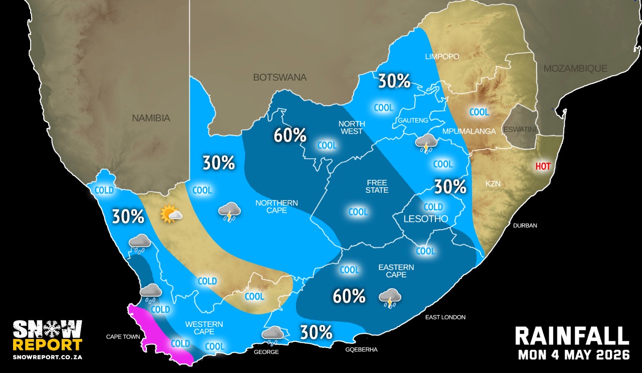
Morning fog can be expected in some parts of the country on Monday.
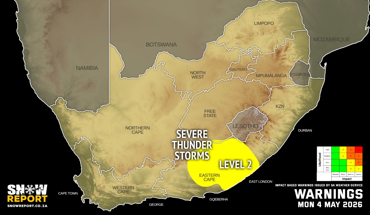
Warnings from the SA Weather Service for Monday:
A. level 2 warning for severe thunderstorms with heavy downpours, resulting in localised flooding of roads, bridges and low-lying areas as well as strong damaging winds and hail leading to localised damage to settlements and infrastructure over the central parts of Eastern Cape.
Extremely high fire danger conditions are expected over the eastern parts of Eastern Cape.
Regional forecasts from the SA Weather Service for Monday:
GAUTENG
Partly cloudy and cool to warm with isolate showers and thundershowers.
MPUMALANGA
Morning fog patches along the escarpment, otherwise partly cloudy and cool to warm with isolated showers and thundershowers in the extreme south-west.
LIMPOPO
Morning fog patches along the escarpment, otherwise partly cloudy and warm with isolated evening showers and thundershowers over the south-western Bushveld.
NORTH-WEST
Partly cloudy, windy and cool to warm with isolated showers and thundershowers, scattered in the west where it will be cloudy.
THE FREE STATE
Partly cloudy, windy and cool to warm with isolated showers and thundershowers, scattered in the west where it will be cloudy.
THE NORTHERN CAPE
Fine over the western interior, otherwise partly cloudy, windy and cool to cold with isolated showers and thundershowers, but scattered in the extreme northeast. Morning fog can be expected over along the coast and adjacent interior. The wind along the coast will be light to moderate northerly to north-westerly.
THE WESTERN CAPE
Cloudy and cool to cold with isolated to scattered showers and rain, but widespread over the south-western parts. It will be fine in the extreme northeast. The wind along the coast will be moderate to fresh westerly to north-westerly, reaching strong along the south-west coast until in the afternoon. It will become fresh to strong south-westerly along the south coast from the afternoon.
THE WESTERN HALF OF THE EASTERN CAPE
Fine at in the morning, otherwise cloudy and warm to hot with scattered showers and thundershowers, but isolated along the coast and adjacent interior. The wind along the coast will be moderate to fresh south-westerly.
THE EASTERN HALF OF THE EASTERN CAPE
Fine at in the morning, otherwise cloudy and warm to hot with scattered showers and thundershowers. The wind along the coast will be light northerly, becoming moderate to fresh south-westerly in the afternoon.
KWAZULU-NATAL
Morning fog patches over the north central interior, otherwise partly cloudy and warm but hot in the north-east. It will become cloudy in the south-west in the evening with isolated showers and thundershowers. The wind along the coast will be light north-westerly in the south in the morning and evening, otherwise light to moderate northerly to north-easterly.
Travellers forecasts from the SA Weather Service for Monday:
PRETORIA
Partly cloudy with isolated showers and thundershowers.
Minimum/Maximum: 12/28°C
JOHANNESBURG
Partly cloudy with isolated showers and thundershowers.
Minimum/Maximum: 15/24°C
VEREENIGING
Partly cloudy with isolated showers and thundershowers.
Minimum/Maximum: 11/24°C
MBOMBELA
Morning fog patches, otherwise partly cloudy.
Minimum/Maximum: 15/27°C
POLOKWANE
Partly cloudy.
Minimum/Maximum: 16/26°C
MAHIKENG
Partly cloudy with isolated showers and thundershowers.
Minimum/Maximum: 10/26°C
VRYBURG
Partly cloudy with scattered showers and thundershowers.
Minimum/Maximum: 12/25°C
BLOEMFONTEIN
Partly cloudy with scattered showers and thundershowers.
Minimum/Maximum: 07/25°C
KIMBERLEY
Cloudy with scattered showers and thundershowers.
Minimum/Maximum: 11/25°C
UPINGTON
Partly cloudy with isolated showers and thundershowers.
Minimum/Maximum: 12/23°C
CAPE TOWN
Cloudy with widespread showers and rain.
Wind: Moderate to fresh westerly to north-westerly, reaching strong until in the afternoon.
Minimum/Maximum: 15/18°C
GEORGE
Partly cloudy with light rain from afternoon.
Wind: Moderate to fresh westerly to north-westerly.
Minimum/Maximum: 12/20°C
GQEBERHA
Partly cloudy with isolated showers.
Wind: Moderate to fresh south-westerly.
Minimum/Maximum: 11/22°C
EAST LONDON
Partly cloudy with scattered showers and thundershowers.
Wind: Might and variable, becoming moderate southwesterly.
Minimum/Maximum: 14/27°C
DURBAN
Partly cloudy.
Wind: Light to moderate northerly to north-easterly.
Minimum/Maximum: 18/30°C
RICHARDS BAY
Partly cloudy.
Wind: Moderate to fresh northerly to north-easterly.
Minimum/Maximum: 20/34°C
PIETERMARITZBURG
Morning fog, otherwise fine.
Minimum/Maximum: 13/30°C
This forecast is usually updated a few times per day.
| SHARE TO |
Please be sure to send photos and videos to us via whatsapp and also tell us where and when they were taken.
Follow our channels