
    Swipe left or right for more maps, and see below for others
Severe thunderstorm and disruptive rain warnings in the east on Monday with flooding possibleBy Staff WriterPublished: 28 September 2025 [updated 29 September] This forecast is for: Mon 29 September 2025 The maps cover: Mon 29 Sep – Wed 01 Oct
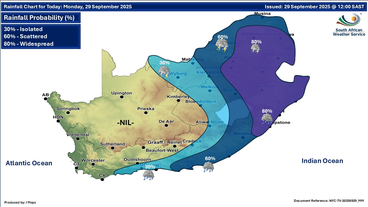
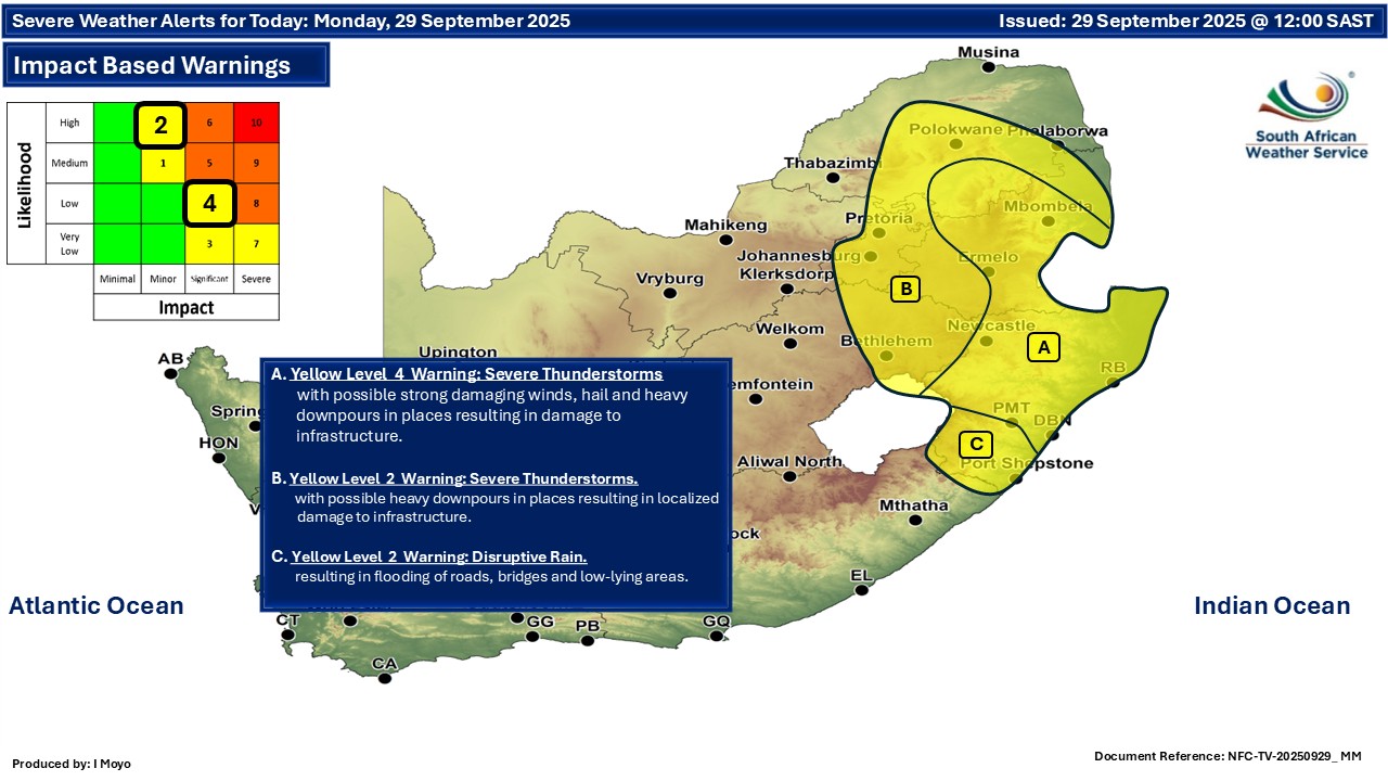
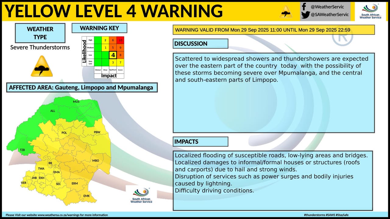
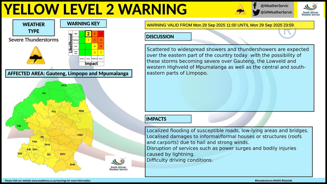
A newer forecast is available by clicking here. Isolated to scattered showers and thundershowers over the central and eastern parts of the country on Monday, but widespread over Gauteng, Mpumalanga and KwaZulu-Natal with possible severe thunderstorms that have a potential of resulting in flooding. ALSO READ: More snowfall for Lesotho and South Africa including on Sani Pass (28-30 September). Warnings from the SA Weather Service for Monday: A. level 4 warning for severe thunderstorms accompanied by heavy downpours are expected to result in flooding of susceptible roads, low-lying areas and bridges as well as excessive lightning, damaging winds and hail leading to localized damage to infrastructure, settlements (informal), property, vehicles, livelihood and livestock over in the central and northern parts of KwaZulu-Natal. B. level 2 warning for severe thunderstorms accompanied by heavy downpours are expected to result in localized flooding of susceptible roads, low-lying areas and bridges as well as damaging winds and hail leading to localized damage to infrastructure, settlements (informal), property, vehicles, livelihood and livestock over the extreme eastern parts of Free State. C. level 2 warning for disruptive rainfall leading to localized flooding of susceptible formal/informal settlements or roads, low-lying areas and bridges, minor motor vehicle accidents due to slippery roads and/reduced visibility over the southern parts of KwaZulu-Natal. Take note that the areas related to the impact warnings above are much more widespread on the maps from the SA Weather Service. Very cold conditions are expected over the interior of the eastern half of the Eastern Cape on Monday. Regional forecasts from the SA Weather Service for Monday: GAUTENG Cloudy and cool with widespread showers and thundershowers, but scattered in the south-west. The expected UVB sunburn index: High MPUMALANGA Morning fog along the escarpment, otherwise cloudy and cool to cold with widespread showers and thundershowers. LIMPOPO Partly cloudy in the south-western Bushveld, otherwise cloudy and cool with scattered to widespread showers and thundershowers. It will be warm in places in the west. NORTH-WEST Partly cloudy and cool to warm with isolated to scattered showers and thundershowers, but widespread in the extreme east. THE FREE STATE Fine in the extreme west, otherwise partly cloudy and cool to cold with isolated to scattered showers and thundershowers, but widespread in the extreme east. It will be cloudy in the east. THE NORTHERN CAPE Morning fog in the extreme west, otherwise fine and cool to warm. The wind along the coast will be moderate to fresh southerly to south-easterly. THE WESTERN CAPE Fine in the west, otherwise partly cloudy and cool to warm, but cloudy along the south coast ad adjacent interior where light rain is possible. The wind along the coast will be fresh to strong southerly to south-easterly, but moderate along the south coast. The expected UVB sunburn index: High THE WESTERN HALF OF THE EASTERN CAPE Partly cloudy and cool to cold with isolated showers and rain south of the escarpment, but scattered along the coast and adjacent interior where it will be cloudy. The wind along the coast will be light to moderate south-easterly, becoming fresh easterly in the afternoon. THE EASTERN HALF OF THE EASTERN CAPE Partly cloudy in the north-west, otherwise cloudy and cold with scattered showers and rain. It will be very cold in places over the interior. The wind along the coast will be light to moderate south-easterly, becoming easterly in the afternoon. KWAZULU-NATAL Cloudy and cool to cold with widespread showers and thundershowers. It will be very cold in the south-west. The wind along the coast will be moderate to fresh southerly to south-easterly. The expected UVB sunburn index: High Travellers forecasts from the SA Weather Service for Monday: PRETORIA Cloudy with widespread showers and thundershowers. Minimum/Maximum: 15/22°C The expected UVB Sunburn Index: High JOHANNESBURG Cloudy with widespread showers and thundershowers. Minimum/Maximum: 10/21°C VEREENIGING Cloudy with scattered showers and thundershowers. Minimum/Maximum: 12/20°C MBOMBELA Morning fog, otherwise cloudy with widespread showers and thundershowers. Minimum/Maximum: 14/17°C POLOKWANE Cloudy with widespread showers and thundershowers. Minimum/Maximum: 16/18°C MAHIKENG Cloudy with scattered showers and thundershowers. Minimum/Maximum: 14/26°C VRYBURG Cloudy with isolated showers and thundershowers. Minimum/Maximum: 10/25°C BLOEMFONTEIN Partly cloudy with isolated showers and thundershowers. Minimum/Maximum: 10/22°C KIMBERLEY Partly cloudy. Minimum/Maximum: 10/24°C UPINGTON Fine. Minimum/Maximum: 14/26°C CAPE TOWN Fine. Wind: Light to moderate southerly to south-easterly. Minimum/Maximum: 13/25°C The expected UVB Sunburn Index: High GEORGE Cloudy with light rain. Wind: Light to moderate easterly to south-easterly. Minimum/Maximum: 13/18°C GQEBERHA Cloudy with scattered showers and rain. Wind: Light to moderate south-easterly. Minimum/Maximum: 14/18°C EAST LONDON Cloudy with scattered showers and rain. Wind: Light to moderate south-easterly. Minimum/Maximum: 15/17°C DURBAN Cloudy with widespread showers and rain. Wind: Moderate to fresh southerly to south-easterly. Minimum/Maximum: 18/19°C The expected UVB Sunburn Index: High RICHARDS BAY Cloudy with widespread showers and thundershowers. Wind: Moderate to fresh southerly to south-easterly. Minimum/Maximum: 17/18°C PIETERMARITZBURG Cloudy with widespread showers and thundershowers. Minimum/Maximum: 11/14°C This forecast is usually updated a few times per day.
Please be sure to send photos and videos to us via whatsapp and also tell us where and when they were taken. Follow our channels
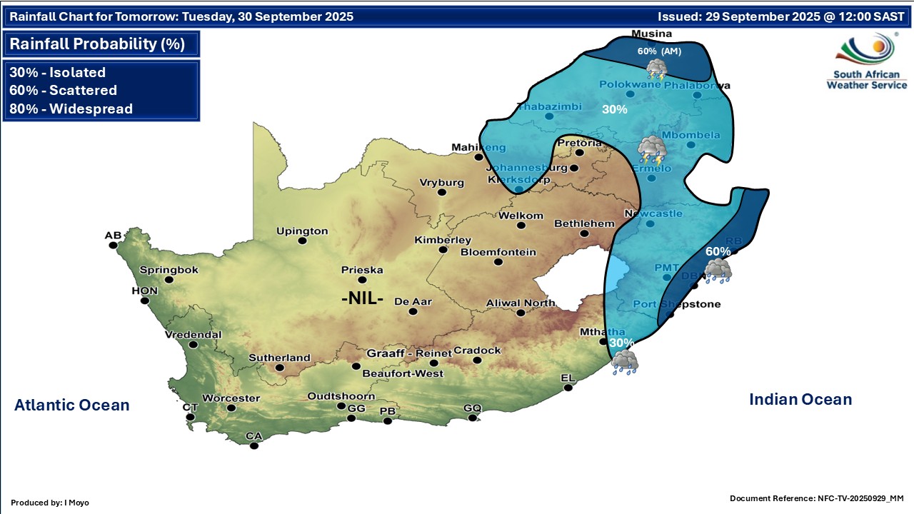
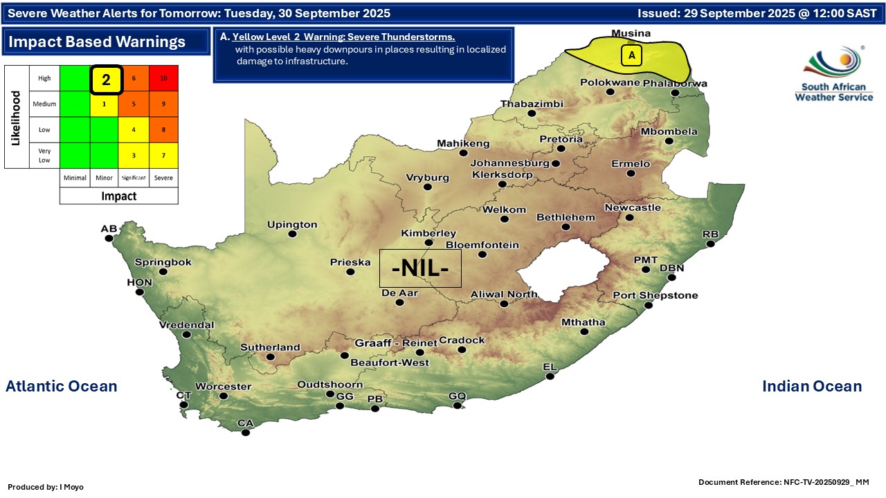
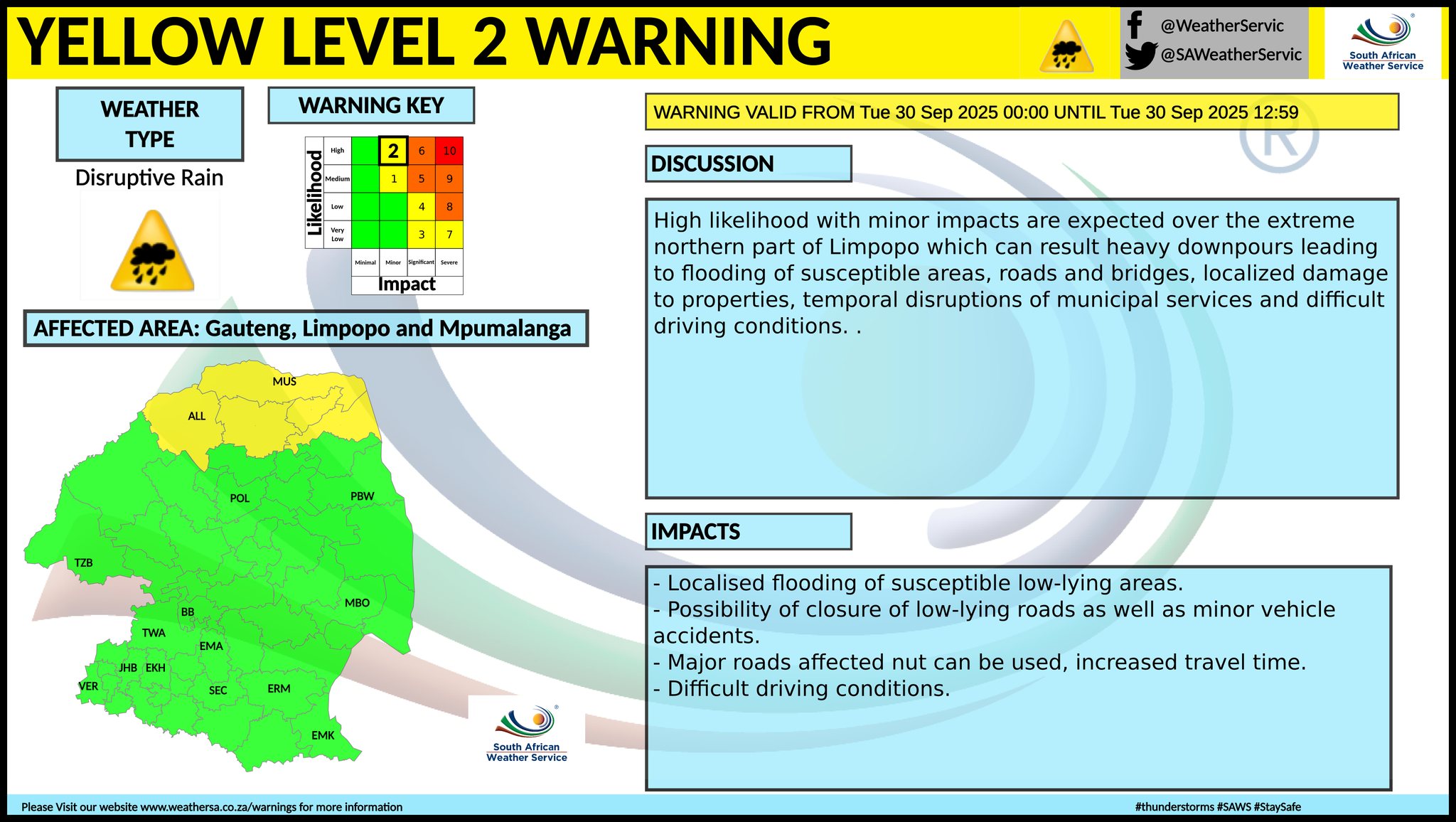
Maps for Tuesday 30 September
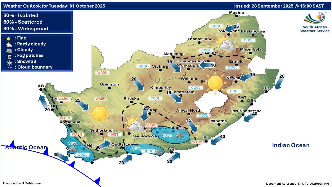
   Maps for Wednesday 1 October
|