
WEDNESDAY WEATHER: LEVEL 6 disruptive rain and LEVEL 5 snow warnings continue – flooding expected
By Staff WriterPublished: 28 July 2026
This forecast is for: Wed 29 July 2026
The maps cover: Wed 29 Jul – Wed 29 Jul
| SHARE TO |
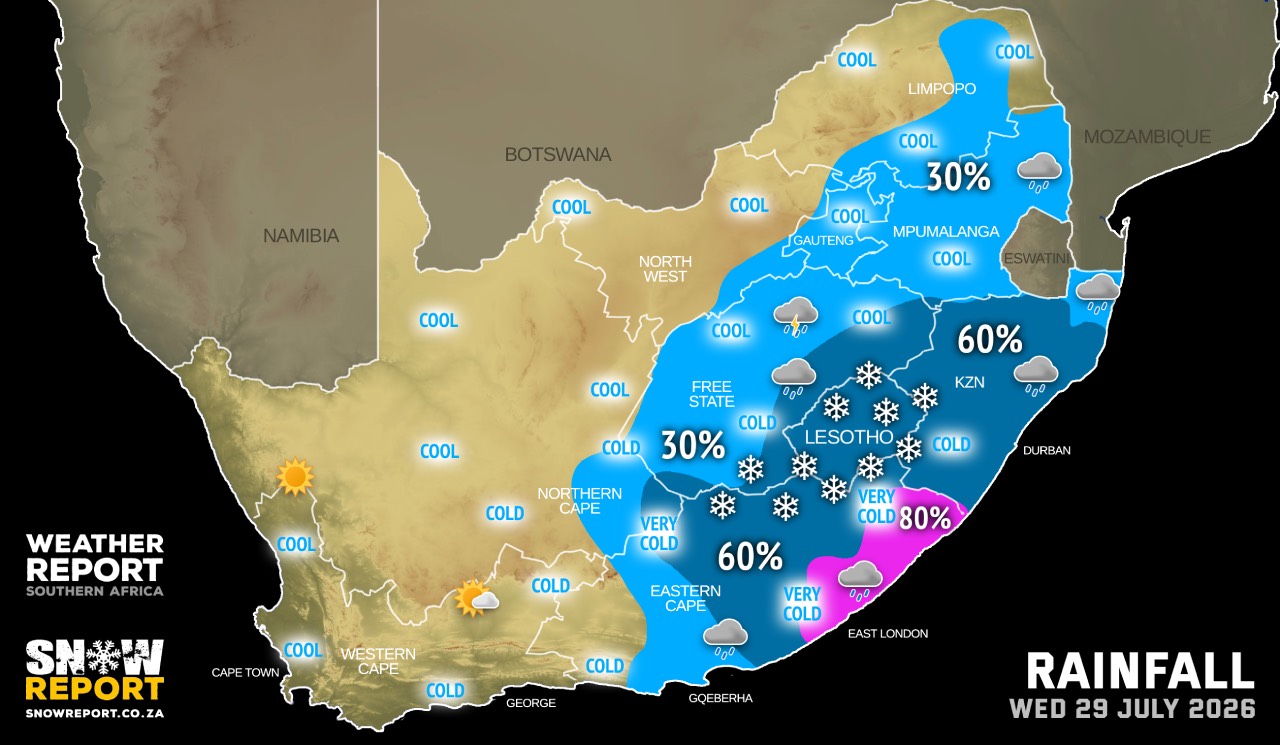
Very cold and wet conditions with light snowfall expected to set in from Tuesday evening in places over Eastern Cape, southern parts of KwaZulu-Natal, southern Free State as well as along the Lesotho borders with the passage of the cut-off low weather system, clearing from the west by Thursday according to the SA Weather Service.
A steep upper trough, becoming a cut-off low will pass over the Eastern Cape causing showers and thundershowers across the province and an accompanying ridging high will result in heavy downpours in places over the province with 30mm to 70mm of rain expected and snowfalls of 10cm to 20cm.
Very cold and wet conditions with light snowfall expected to set in from Wednesday evening in places over Eastern Cape, southern parts of KwaZulu-Natal, southern Free State as well as along the Lesotho borders with the passage of the cut-off-low weather system, clearing from the west by Thursday.
Farmers are advised to take precautionary measures to mitigate negative impact under such adverse weather conditions.
Warnings from the SA Weather Service:
Note that there are two maps indicating the warnings.
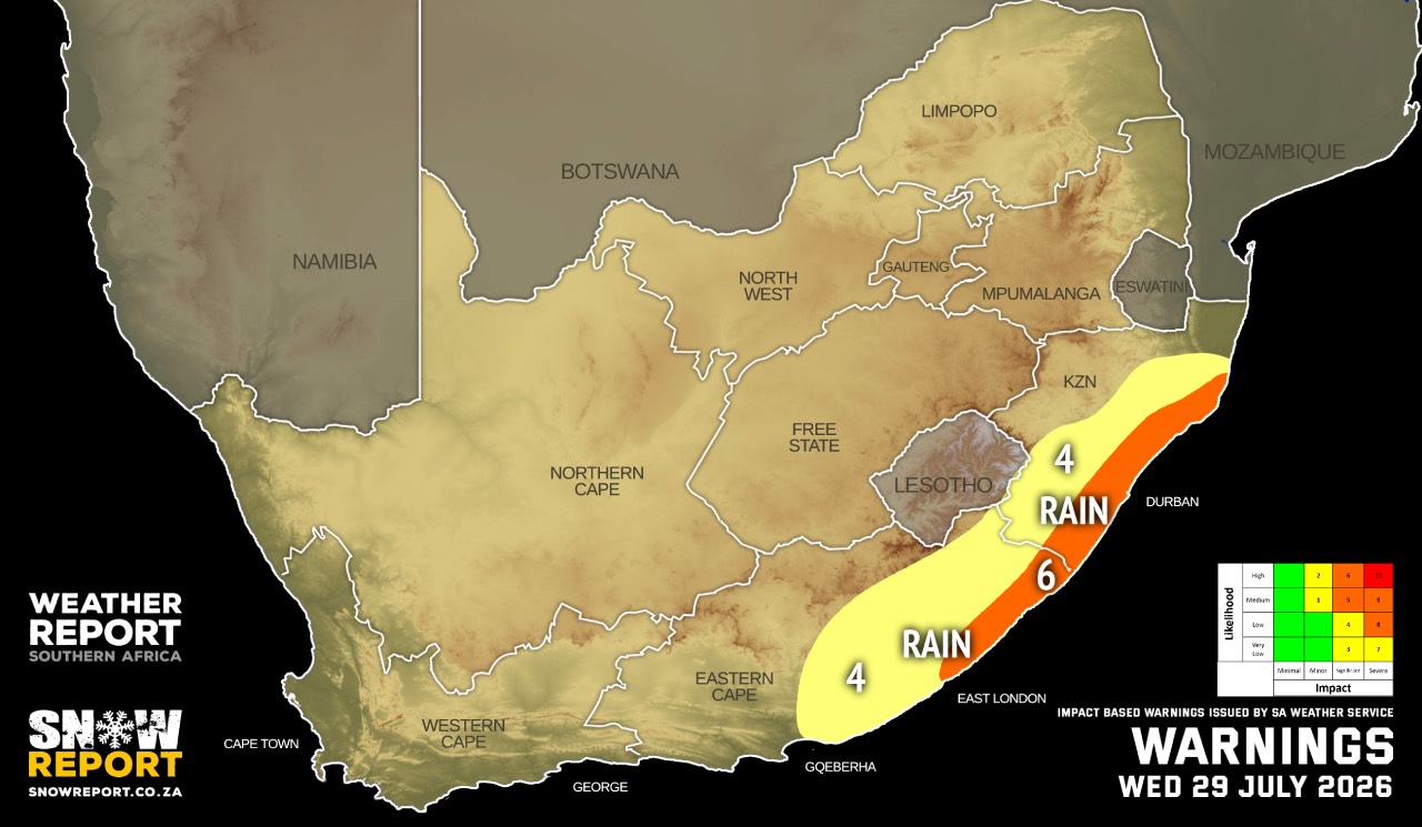
A. level 6 warning for disruptive rainfall resulting in flooding of bridges/roads/settlements and damage to property/infrastructure in places along the coast and adjacentinterior between East London (Eastern Cape) and Cape Vidal (KwaZulu-Natal).
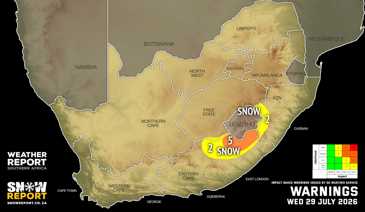
B. level 5 warning for disruptive snowfall resulting in traffic disruptions, disruption to essential services and some communities temporarily cut-off in places overthe extreme north-eastern high-ground of the Eastern Cape.
C. level 2 warning for disruptive rainfall resulting in flooding of bridges/roads/settlements and damage to property/infrastructure over the south-eastern parts of theEastern Cape and the eastern parts of KwaZulu-Natal, except in the extreme north-east. Note the impact warning map earlier today had this as a level 4, but SAWS has it listed as a level 2 elsewhere.
E. level 2 warning for disruptive snowfall resulting in traffic disruptions, disruption to essential services and some communities temporarily cut-off in places over the north-eastern high-ground of the Eastern Cape and Drakensberg area of KwaZulu-Natal.
SEE ALSO: Disruptive snowfall from Tuesday (detailed snow forecast).
Regional forecasts from the SA Weather Service:
GAUTENG
Partly cloudy and cool to cold with isolated showers and rain.
MPUMALANGA
Drizzle along the escarpment, otherwise partly cloudy and cool with isolated showers and rain. It will be cloudy in the morning.
LIMPOPO
Drizzle along the escarpment, otherwise partly cloudy and cool with isolated showers in the south-east. It will be cloudy in the east at first.
NORTH-WEST
Partly cloudy and cool with isolated showers and thundershowers in the extreme south-east.
THE FREE STATE
Partly cloudy and cold to cool with isolated showers and thundershowers but scattered along the Lesotho boarder. Light snowfall is possible along the Lesotho boarder and in the extreme south-west.
THE NORTHERN CAPE
Fine to partly cloudy and cold to cool but very cold over the southern parts with isolated to scattered showers and thundershowers in the south-east. Light snowfall is possible in the extreme south-east. The wind along the coast will be fresh to strong southerly to south-easterly.
THE WESTERN CAPE
Partly cloudy to cloudy in the east, otherwise fine and cool to warm but cold in parts of the Central Karoo. The wind along the coast will be fresh to strong easterly to south-easterly.
THE WESTERN HALF OF THE EASTERN CAPE
Cool in places along the coast, otherwise cloudy and cold with isolated showers and rain, clearing up in the afternoon. Snowfalls are expected in the high-lying areas. The wind along the coast will be moderate to fresh easterly.
THE EASTERN HALF OF THE EASTERN CAPE
Cloudy and cold to very cold with scattered showers and rain, but widespread south of escarpment. Snowfalls are expected over high-lying areas. The wind along the coast will be moderate to fresh south-easterly.
KWAZULU-NATAL
Cloudy and cold to cool with scattered showers and rain, but isolated in the extreme north-east. The wind along the coast will be southerly to south-easterly.
Travellers forecasts from the SA Weather Service:
PRETORIA
Partly cloudy with isolated rain and showers.
Minimum/Maximum: 7/20°C
JOHANNESBURG
Partly cloudy with isolated rain and showers.
Minimum/Maximum: 5/17°C
VEREENIGING
Partly cloudy with isolated rain and showers.
Minimum/Maximum: 3/18°C
MBOMBELA
Partly cloudy with isolated showers.
Minimum/Maximum: 10/20°C
POLOKWANE
Partly cloudy.
Minimum/Maximum: 7/21°C
MAHIKENG
Partly cloudy.
Minimum/Maximum: 5/22°C
VRYBURG
Partly cloudy.
Minimum/Maximum: 4/23°C
BLOEMFONTEIN
Partly cloudy with isolated showers and thundershowers
Minimum/Maximum: 6/18°C
KIMBERLEY
Partly cloudy with isolated showers and thundershowers.
Minimum/Maximum: 7/21°C
UPINGTON
Partly cloudy becoming fine.
Minimum/Maximum: 6/23°C
CAPE TOWN
Fine.
Wind: Light and variable.
Minimum/Maximum: 11/22°C
GEORGE
Partly cloudy.
Wind: Moderate north-easterly, but fresh south-easterly in
the afternoon.
Minimum/Maximum: 8/18°C
GQEBERHA
Cloudy with isolated showers and rain in the morning, becoming partly cloudy.
Wind: Moderate to fresh easterly.
Minimum/Maximum: 13/18°C
KuGOMPO CITY
Cloudy with widespread of showers
Wind: Moderate south-easterly.
Minimum/Maximum: 12/17°C
DURBAN
Cloudy with scattered showers and
Wind: Moderate to fresh southerly
Minimum/Maximum: 15/18°C
RICHARDS BAY
Cloudy with scattered showers and rain.
Wind: Moderate to fresh southerly to south-easterly.
Minimum/Maximum: 16/20°C
PIETERMARITZBURG
Cloudy with scattered showers and rain.
Minimum/Maximum: 9/14°C
This forecast is usually updated a few times per day.
| SHARE TO |
Please be sure to send photos and videos to us via whatsapp and also tell us where and when they were taken.
Follow our channels