
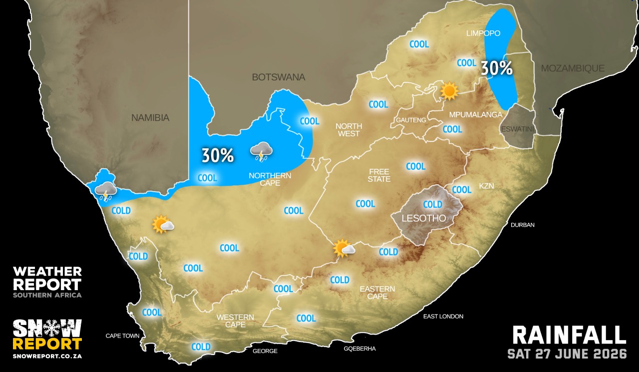
SATURDAY WEATHER: Mainly dry but cold in places in advance of another cold front on Sunday
By Staff WriterPublished: 26 June 2026
This forecast is for: Sat 27 June 2026
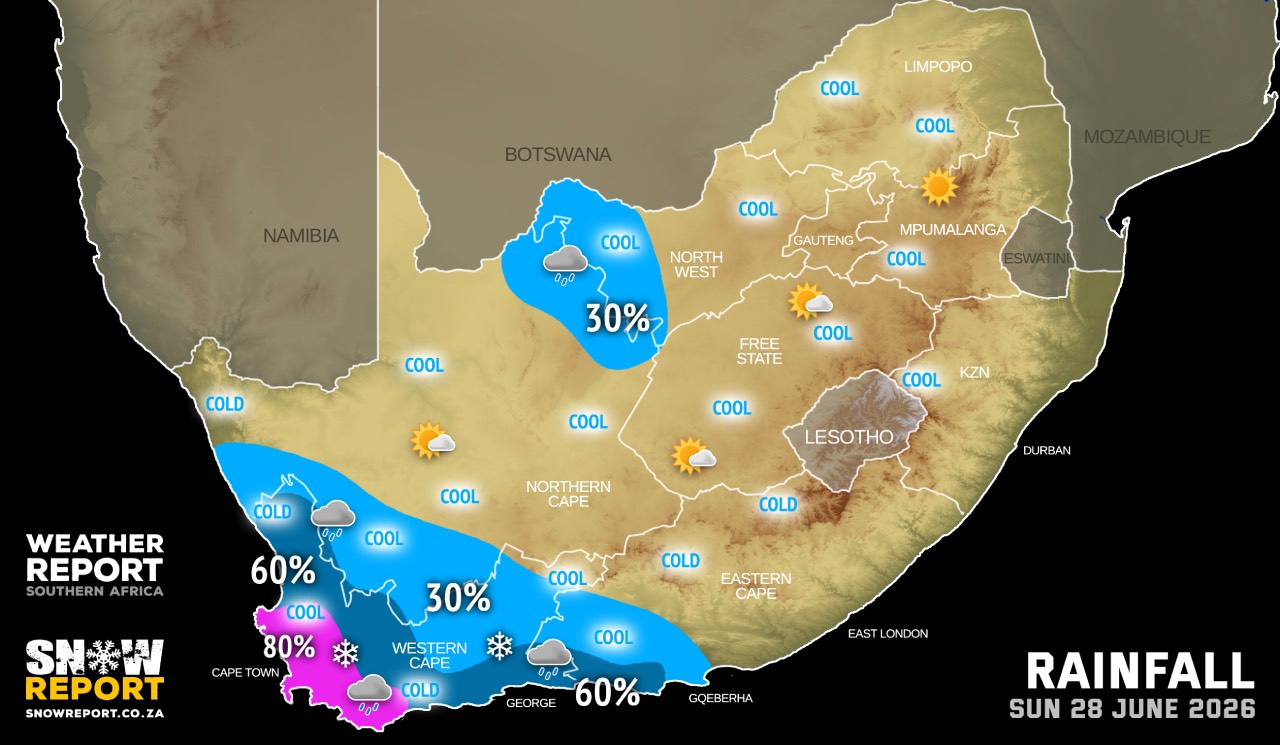
The maps cover: Sat 27 Jun – Sun 28 Jun
| SHARE TO |
Partly cloudy and cool to warm with isolated showers and thundershowers on Saturday, becoming scattered in the south-west on Sunday as another cold front makes landfall.
A well developed cold front associated with a steep upper-air trough is expected to make landfall over the western parts of the Western Cape on Sunday resulting in strong to near gale-force north-westerly winds of 40-55 km/h with gusts of 70-90 km/h over the Hantam and Karoo Hoogland municipalities in the Northern Cape, as well as the western parts of the Western Cape.
Very cold, wet and windy conditions are expected over the southern parts of the Namakwa District Municipality in the Northern Cape as well as over the Cape Winelands District Municipality in the Western Cape on Sunday, spreading over the Central and Little Karoo District Municipality in the Western Cape on Monday.
Strong north-westerly winds can be expected in places over the interior of the Eastern Cape, especially the high lying areas.
Warnings from the SA Weather Service:
A. level 2 warning for reduced visibility due to dense fog leading to difficulty in driving conditions, road traffic accidents as well as short-term travel with longer travel times over the Highveld and in places over the escarpment in Mpumalanga.
Warnings from the SA Weather Service for Sunday:
A. level 4 warning disruptive rainfall leading to localised flooding of susceptible formal/informal settlements or roads, low lying areas and bridges over the City of Cape Town and the Cape Winelands District Municipalities in the Western Cape.
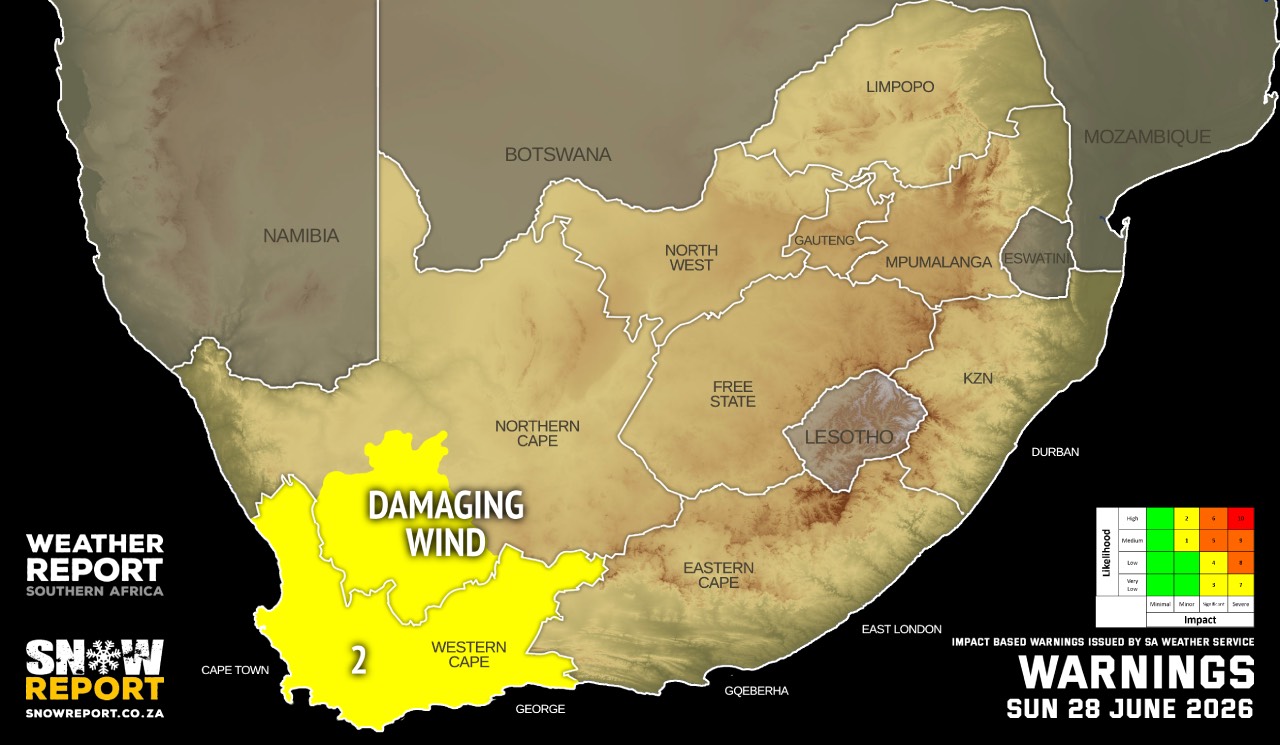
B. level 2 warning for damaging wind and waves leading to difficulty in navigation at sea between Cape Columbine and Cape Agulhas in the Western Cape until Monday.
C. level 2 warning for damaging interior winds resulting in localised problems for high-sided vehicles on prone routes in the Western Cape and over the southern parts of Namakwa District Municipality in the Northern Cape.
SEE ALSO: Snow possible in three South African provinces from Sunday.
Regional forecasts from the SA Weather Service:
GAUTENG
Morning fog patches in the south-east, otherwise partly cloudy and cold to cool.
MPUMALANGA
Fog in vast places with drizzle along the northern escarpment in the morning, otherwise partly cloudy and cold to cool.
LIMPOPO
Cloudy with fog in most places and drizzle along the escarpment in the morning, otherwise partly cloudy and cool.
NORTH-WEST
Partly cloudy and cool with isolated showers and thundershowers in the extreme north-west.
THE FREE STATE
Morning fog patches over the eastern parts, otherwise partly cloudy and cold to cool.
THE NORTHERN CAPE
Morning and evening fog patches along the coastline, otherwise partly cloudy, windy and cold to cool with isolated showers and thundershowers in the northern parts. The wind along the coast will be light and variable, becoming moderate to fresh north-westerly in the evening.
THE WESTERN CAPE
Cloudy over the south-western parts with morning fog, otherwise partly cloudy and cool to cold. The wind along the coast will be light and variable along the south coast, otherwise moderate to fresh westerly to north-westerly, reaching strong along the south-west coast from the afternoon.
THE WESTERN HALF OF THE EASTERN CAPE
Morning fog in places over the southern interior, otherwise partly cloudy and cool to warm, becoming cloudy with fog along the coast in the evening. The wind along the coast will be moderate to fresh north-westerly.
THE EASTERN HALF OF THE EASTERN CAPE
Fine in places in the morning, otherwise partly cloudy and cool, but warm in places south of the escarpment. The wind along the coast will be light and variable in places at first, otherwise moderate to fresh north-westerly, becoming north-easterly during the afternoon.
KWAZULU-NATAL
Morning fog over the interior, otherwise fine and cool to warm but partly cloudy over the north-east. The wind along the coast will be light to moderate northerly to north-easterly.
Travellers forecasts from the SA Weather Service:
PRETORIA
Partly cloudy.
Minimum/Maximum: 08/19°C
JOHANNESBURG
Partly cloudy.
Minimum/Maximum: 06/18°C
VEREENIGING
Partly cloudy.
Minimum/Maximum: 04/17°C
MBOMBELA
Cloudy with morning fog and drizzle, otherwise partly cloudy.
Minimum/Maximum: 09/19°C
POLOKWANE
Cloudy with fog patches in the morning, otherwise partly cloudy.
Minimum/Maximum: 05/19°C
MAHIKENG
Partly cloudy.
Minimum/Maximum: 08/20°C
VRYBURG
Partly cloudy.
Minimum/Maximum: 06/22°C
BLOEMFONTEIN
Partly cloudy.
Minimum/Maximum: 05/19°C
KIMBERLEY
Partly cloudy.
Minimum/Maximum: 08/21°C
UPINGTON
Partly cloudy with isolated showers and thundershowers.
Minimum/Maximum: 12/26°C
CAPE TOWN
Cloudy with morning fog patches.
Wind: Moderate to fresh westerly to north-westerly, reaching strong from the afternoon.
Minimum/Maximum: 14/18°C
GEORGE
Partly cloudy.
Wind: Light and variable at first, otherwise moderate to fresh westerly to south-westerly.
Minimum/Maximum: 13/21°C
GQEBERHA
Fine in the early morning, otherwise partly cloudy.
Wind: Moderate to fresh north-westerly, becoming south-westerly in the afternoon.
Minimum/Maximum: 16/26°C
KuGOMPO CITY
Fine in the early morning, otherwise partly cloudy.
Wind: Light north-westerly, but light and variable during the afternoon.
Minimum/Maximum: 13/27°C
DURBAN
Fine.
Wind: Light to moderate northerly to north-easterly.
Minimum/Maximum: 14/26°C
RICHARDS BAY
Fine.
Wind: Light to moderate northerly to north-easterly.
Minimum/Maximum: 14/27°C
PIETERMARITZBURG
Morning fog, otherise fine.
Minimum/Maximum: 08/25°C
This forecast is usually updated a few times per day.
| SHARE TO |
Please be sure to send photos and videos to us via whatsapp and also tell us where and when they were taken.
Follow our channels