
MONDAY WEATHER: A cold, wet or foggy start to the week with wind and wave warnings
By Staff WriterPublished: 26 April 2026
This forecast is for: Mon 27 April 2026
The maps cover: Mon 27 Apr – Mon 27 Apr
| SHARE TO |
The latest forecast is available by clicking here.
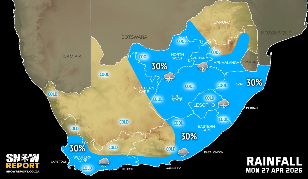
Cold to very cold, wet and windy conditions are expected over the southern parts of Namakwa region of the Northern Cape, Central Karoo, Cape Winelands, western parts of the Overberg, and the City of Cape Town districts of the Western Cape on Monday.
Morning or evening fog can be expected in the eastern part of the country.
SEE ALSO: More snowfall possible this weekend – Lesotho and the Western Cape.
Warnings from the SA Weather Service for Monday:
A. level 2 warning for strong damaging winds leading to localised disruption to small harbours and ports between Cape Point and Port Edward. Also leading to damage to infrastructure, problems for high-sided vehicles and disruptions to travel services over the extreme south-western parts of the Eastern Cape.
B. level 2 warning for damaging waves leading to difficulty navigating at sea for small vessels, and disruptions of beach front activities along the coast of the Eastern Cape.
C. level 1 warning for strong damaging winds leading to localised disruption to small harbours and ports along the coast of KwaZulu-Natal.
D. level 1 warning for damaging waves leading to difficulty navigating at sea for small vessels, and disruptions of beach front activities between Cape Columbine and Plettenberg Bay, and along the coast of KwaZulu-Natal.
Regional forecasts from the SA Weather Service for Monday:
GAUTENG
Morning fog, otherwise partly cloudy and cool to warm with isolated showers and thundershowers.
MPUMALANGA
Morning fog over the western Highveld, otherwise fine and cool to warm, but hot in the Lowveld, becoming partly cloudy with isolated rain and showers over the south-western Highveld, spreading to the escarpment in the evening.
LIMPOPO
Morning fog in the south-west, otherwise fine and warm, but hot in the Lowveld, partly cloudy in the afternoon in the south-west with isolated showers in the extreme south-west.
NORTH WEST
Partly cloudy and cool to warm with isolated showers and thundershowers.
THE FREE STATE
Partly cloudy and cold to cool, with isolated showers and thundershowers.
THE NORTHERN CAPE
Partly cloudy and cold to cool with isolated morning showers and thundershowers in the extreme north-east, otherwise fine. The wind along the coast will be moderate to fresh southeasterly.
THE WESTERN CAPE
Cloudy to partly cloudy and cold with showers and rain over the south-western and southern parts. The wind along the coast will be moderate to fresh southwesterly to westerly but strong along the south coast.
THE WESTERN HALF OF THE EASTERN CAPE
Partly cloudy and cold to cool with isolated showers of rain along the coast. The wind along the coast will be fresh to strong south-westerly.
THE EASTERN HALF OF THE EASTERN CAPE
Partly cloudy and cool with isolated showers and thundershowers. The wind along the coast will be strong south-westerly.
KWAZULU-NATAL
Evening fog over the western and central interior, otherwise partly cloudy and cool to warm with isolated showers and rain. It will be cloudy along the coast. The wind along the coast will be moderate to fresh southerly to south-westerly.
Travellers forecasts from the SA Weather Service for Monday:
PRETORIA
Morning fog, otherwise partly cloudy with isolated showers and thundershowers.
Minimum/Maximum: 12/25°C
JOHANNESBURG
Morning fog, otherwise partly cloudy with isolated showers and thundershowers.
Minimum/Maximum: 10/24°C
VEREENIGING
Morning fog, otherwise partly cloudy with isolated showers and thundershowers.
Minimum/Maximum: 10/24°C
MBOMBELA
Partly cloudy with isolated showers and rain.
Minimum/Maximum: 13/28°C
POLOKWANE
Morning fog, otherwise partly cloudy.
Minimum/Maximum: 11/28°C
MAHIKENG
Partly cloudy with isolated morning showers and rain, becoming fine.
Minimum/Maximum: 13/25°C
VRYBURG
Partly cloudy with isolated morning showers and thundershowers.
Minimum/Maximum: 14/23°C
BLOEMFONTEIN
Partly cloudy with isolated morning showers and rain.
Minimum/Maximum: 12/18°C
KIMBERLEY
Partly cloudy with isolated morning showers and thundershowers.
Minimum/Maximum: 10/18°C
UPINGTON
Partly cloudy becoming fine in the afternoon.
Minimum/Maximum: 12/19°C
CAPE TOWN
Partly cloudy with isolated showers and rain.
Wind: Light and variable in the morning, otherwise moderate south-westerly.
Minimum/Maximum: 12/15°C
GEORGE
Cloudy with isolated showers and rain.
Wind: Fresh to strong westerly to south-westerly.
Minimum/Maximum: 10/15°C
GQEBERHA
Partly cloudy with isolated showers and rain.
Wind: Fresh to strong south-westerly.
Minimum/Maximum: 13/18°C
EAST LONDON
Partly cloudy with isolated showers and thundershowers.
Wind: Strong south-westerly.
Minimum/Maximum: 14/21°C
DURBAN
Cloudy with isolated showers and rain.
Wind: Light north-westerly, becoming moderate to fresh southerly to south-westerly from mid-morning, reaching strong at times.
Minimum/Maximum: 21/25°C
RICHARDS BAY
Cloudy with isolated showers and rain.
Wind: Light to moderate northerly to north-westerly, becoming moderate to fresh southerly to south-westerly from late morning, reaching strong at times.
Minimum/Maximum: 20/29°C
PIETERMARITZBURG
Cloudy with isolated showers and rain and evening fog patches.
Minimum/Maximum: 14/23°C
This forecast is usually updated a few times per day.
| SHARE TO |
Please be sure to send photos and videos to us via whatsapp and also tell us where and when they were taken.
Follow our channels