
           Swipe left or right for more maps, and see below for others
Six warnings for disruptive rainfall, damaging wind and waves, and disruptive snowfall on ThursdayBy Staff WriterPublished: 25 June 2025 [updated 26 June] This forecast is for: Thu 26 June 2025 The maps cover: Thu 26 Jun – Sat 28 Jun
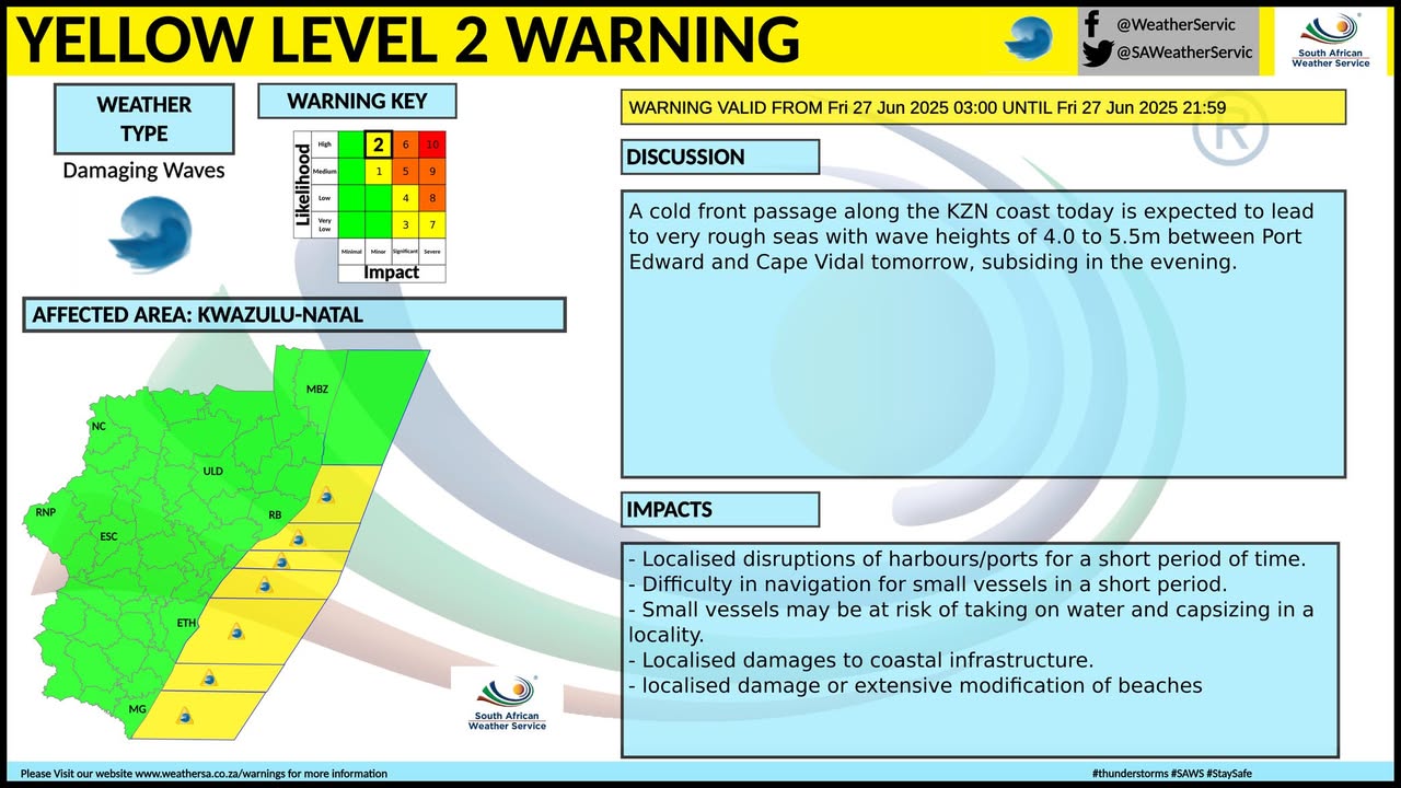
A newer forecast is available by clicking here. You can listen to this daily weather forecast as a 6 minute podcast by pressing the > play button above. According to the SA Weather Service, an intense cold front that made landfall on Wednesday is expected to continue to affect the Western, Northern Cape and Free State provinces until Friday. The cold front will be passing through the Eastern Cape on Thursday and the public and small stock farmers are advised that snow, cold to very cold and windy conditions as well as very rough seas can be expected in places over the Eastern Cape. ALSO READ: More snowfall from Wednesday – four SA provinces, Lesotho and Namibia. Warnings from the SA Weather Service for Thursday: A. level 4 warning for damaging waves resulting in the damage to coastal infrastructure and disruption to beach front activities are expected along the coast between Alexander Bay and Plettenberg Bay. B. level 2 warning for damaging coastal winds resulting in localised disruption of small harbours and/or a port for a short period of time, small vessels at risk of taking on water and capsizing in a locality and difficulty in navigation between Port Edward and Cape Vidal as wells between Cape Agulhas and East London. C. level 2 warning for damaging waves resulting in the damage to coastal infrastructure and disruption to beachfront activities are expected along the coast between Plettenberg Bay and East London. D. level 2 warning for damaging interior winds leading to localised problems for high-sided vehicles on prone routes and some transport services affected by wind is expected over Free State, the south eastern parts of the Northern Cape and north western parts of KwaZulu-Natal as well as along the coast and adjacent interior of the Eastern Cape between Plettenberg Bay and East London. E. level 2 warning for disruptive rainfall leading to localised flooding of susceptible formal and informal settlements or roads, and low-lying areas over Cederberg, City of Cape Town, Cape Winelands, and the western parts of the Overberg District (Western Cape) in the morning. F. level 1 warning for disruptive snowfall resulting in traffic disruption due to icy roads, isolated loss of vulnerable livestock and crops over Senqu and Elundini local municipalities of the Eastern Cape. Extreme high fire danger conditions are expected over the Dr Pixley ka Isaka Seme local municipality in Mpumalanga, as well as Ba-Phalaborwa and Maruleng local municipalities in Limpopo. Regional forecasts from the SA Weather Service for Thursday: 1. GAUTENG Partly cloudy in the extreme south, otherwise fine, windy and cool. The expected UVB sunburn index: High 2. MPUMALANGA Windy in the Highveld, otherwise fine and cool to warm, but partly cloudy in the south-west, spreading to the escarpment by the evening. 3. LIMPOPO Windy in the west, otherwise fine and cool to warm, but partly cloudy in the extreme south-west, spreading to the central part by the evening. 4. NORTH-WEST Partly cloudy, windy and cold to cool with isolated showers and thundershowers in the south. 5. FREE STATE Partly cloudy, windy and cold to very cold with isolated showers and thundershowers. 6. NORTHERN CAPE Cloudy in the western and southern parts otherwise partly cloudy, windy and cold to very cold with isolated showers and thundershowers. The wind along the coast will be moderate to fresh westerly to south-westerly. 7. WESTERN CAPE Cloudy, windy and cold with isolated to scattered showers and rain but widespread in the south-west. Light snow on the high-ground is expected. The wind along the coast will be fresh to strong south-westerly but strong to gale force westerly to north-westerly along the south coast. It will become light southerly along the south-west coast in the evening. The expected UVB sunburn index: Low 8. WESTERN HALF OF THE EASTERN CAPE Cool with scattered showers in places along the coast, otherwise cloudy, windy and cold to very cold with isolated light showers. Light snowfalls can be expected in places over the northern high lying areas. The wind along the coast will be moderate to fresh north-westerly, but strong to gale force westerly from late morning. 9. EASTERN HALF OF THE EASTERN CAPE Cloudy, windy and cold to very cold with snow over the northern interior, otherwise partly cloudy to cloudy and cool to cold with isolated showers and rain. The wind along the coast will be Light to moderate north-westerly, but south-westerly from late morning, becoming fresh to strong from the south. 10. KWAZULU-NATAL Fine until mid-morning, otherwise partly cloudy and cool but warm in the east. There will be isolated showers and rain from late afternoon except in the places in the north. The wind along the coast will be moderate to fresh north-easterly, but light to moderate north-westerly in the south, becoming southerly to south-westerly mid-morning, spreading northwards from the afternoon. The expected UVB sunburn index: Low Travellers forecasts from the SA Weather Service for Thursday: PRETORIA Find and windy. Minimum/Maximum: 7/21°C The expected UVB Sunburn Index: High JOHANNESBURG Find and windy. Minimum/Maximum: 4/20°C VEREENIGING Partly cloudy and windy. Minimum/Maximum: 3/18°C MBOMBELA Fine. Minimum/Maximum: 7/26°C POLOKWANE Fine. Minimum/Maximum: 11/24°C MAHIKENG Partly cloudy and windy. Minimum/Maximum: 10/17°C VRYBURG Partly cloudy and windy. Minimum/Maximum: 9/14°C BLOEMFONTEIN Partly cloudy and windy with isolated showers and thundershowers. Minimum/Maximum: 8/12°C KIMBERLEY Partly cloudy and windy isolated showers and thundershowers. Minimum/Maximum: 9/12°C UPINGTON Partly cloudy and windy. Minimum/Maximum: 7/12°C CAPE TOWN Cloudy with widespread showers and rain clearing from the afternoon. Wind: Moderate to fresh south-westerly but strong at first, becoming light and variable in the evening. Minimum/Maximum: 11/13°C The expected UVB Sunburn Index: Low GEORGE Partly cloudy and windy, becoming cloudy with scattered showers and rain from late morning. Wind: Fresh to strong westerly to north-westerly reaching near gale in the morning, becoming moderate to fresh westerly to south-westerly in the afternoon. Minimum/Maximum: 11/14°C GQEBERHA Cloudy with scattered afternoon showers. Wind: Moderate to fresh north-westerly, but strong to gale force westerly in the afternoon. Minimum/Maximum: 15/19°C EAST LONDON Cloudy in the morning and evening, otherwise partly cloudy. Wind: Moderate to fresh westerly, but strong in the afternoon. Minimum/Maximum: 16/21°C DURBAN Fine, becoming partly cloudy in the afternoon, with evening isolated showers and rain. Wind: Light to moderate, becoming southerly to south-westerly. Minimum/Maximum: 16/30°C The expected UVB Sunburn Index: Low RICHARDS BAY Fine, becoming partly in the afternoon with evening isolated showers and rain. Wind: Light to moderate northerly to north-westerly, becoming moderate to fresh southerly to south-westerly. Minimum/Maximum: 16/30°C PIETERMARITZBURG Fine, becoming partly cloudy late morning with evening isolated showers and rain. Minimum/Maximum: 9/25°C This forecast is usually updated a few times per day.
Please be sure to send photos and videos to us via whatsapp and also tell us where and when they were taken. Follow our channels
Maps for Friday 27 June
   Maps for Saturday 28 June

|