
SUNDAY WEATHER: Cold, wet, windy and rough seas, and more snow possible
By Staff WriterPublished: 25 April 2026 [updated 26 April]
This forecast is for: Sun 26 April 2026
The maps cover: Sun 26 Apr – Sun 26 Apr
| SHARE TO |
The latest forecast is available by clicking here.
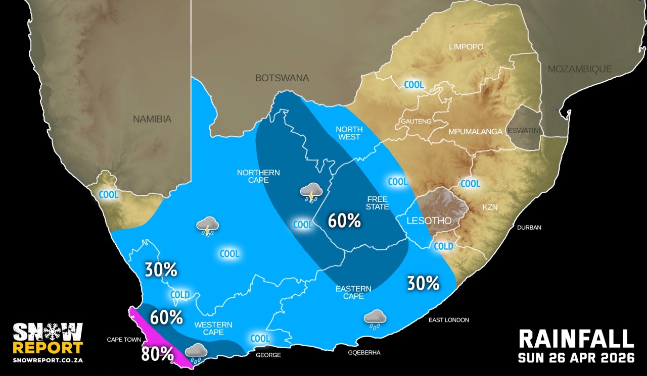
Cold to very cold, wet and windy conditions are expected over the southern parts of Namakwa region of the Northern Cape, Central Karoo, Cape Winelands, western parts of the Overberg, and the City of Cape Town districts of the Western Cape into Monday.
A cold front making landfall on Sunday is expected to bring near gale to gale-force west to north-westerly winds (50-65 km/h), with gusts reaching 60-75 km/h. These conditions are likely to affect the Karoo Hoogland Municipality in the Namakwa District of the Northern Cape, the Central Karoo District and the Breede Valley Municipality in the Western Cape on Sunday, including the coastal areas between Cape Point and Plettenberg Bay from this evening through to Monday morning.
Windy conditions can be expected in places over the interior of the Eastern Cape.
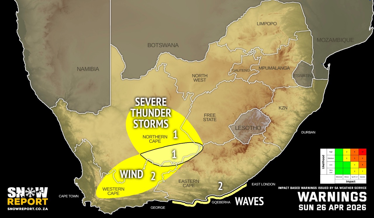
Damaging winds are expected along the coast from very early Monday morning until late afternoon between Storms River and Port Alfred.
Gale force off-shore south-westerly winds are likely between Algoa Bay and East London on Monday morning, subsiding by late afternoon.
Very rough seas with wave heights between 4m and 6m are expected between Cape St Francis and East London until Monday.
Morning or evening fog can be expected in some parts of the country on Sunday.
SEE ALSO: More snowfall possible this weekend – Lesotho and the Western Cape.
Warnings from the SA Weather Service for Sunday:
A. level 2 warning for strong damaging winds leading to damage to infrastructure, settlements, problems for highsided vehicles, and travel services and time affected over the northern parts of the Western Cape, and the south central parts of the Northern Cape.
B. level 1 warning for severe thunderstorms with strong damaging winds and heavy downpours leading to localised flooding and damages to susceptible formal/informal settlements and infrastructure over the central and south-eastern parts of Northern Cape.
C. level 1 warning for strong damaging winds leading to damage to infrastructure, settlements, problems for highsided vehicles, and travel services and time affected over the south-eastern parts of the Northern Cape.
Extremely high fire danger conditions are expected over the Central Karo oof the Western Cape, also in places over Dr Beyers Naude, Blue Crane, Inxuba Yethemba and Enoch Mgijima municipalities of the Eastern Cape, and the southern parts of the Northern Cape.
Regional forecasts from the SA Weather Service for Sunday:
GAUTENG
Morning fog in the south-west, otherwise partly cloudy and cool, but warm in the extreme north.
MPUMALANGA
Cloudy with morning fog, otherwise partly cloudy and cool to warm.
LIMPOPO
Cloudy with morning fog, otherwise partly cloudy and cool to warm.
NORTH WEST
Partly cloudy and cool to warm with isolated to scattered showers and thundershowers in the west.
THE FREE STATE
Partly cloudy and cool with isolated to scattered showers and thundershowers, except in the east.
THE NORTHERN CAPE
Cloudy along the coast, otherwise partly cloudy, windy and cool to warm with isolated to scattered showers and thundershowers, except in the north-west. The wind along the coast will be moderate to fresh northwesterly.
THE WESTERN CAPE
Partly cloudy and cool to warm with isolated showers and rain, but scattered to widespread in the south-west where it will be cloudy. The wind along the coast will be moderate to fresh westerly to north-westerly.
THE WESTERN HALF OF THE EASTERN CAPE
Partly cloudy and warm with isolated showers and thundershowers, but scattered in places in the north. Windy conditions are expected in places over the interior. The wind along the coast will be moderate to fresh southwesterly.
THE EASTERN HALF OF THE EASTERN CAPE
Fine and hot in places in the south-east, otherwise partly cloudy and warm with isolated showers and thundershowers. The wind along the coast will be light and variable, becoming moderate north-easterly in the afternoon and fresh to strong from the evening.
KWAZULU-NATAL
Morning and evening fog patches over the northern interior, otherwise fine and cool to warm but hot along the north coast. The wind along the coast will be moderate to fresh northerly to north-westerly becoming north-easterly from late morning.
Travellers forecasts from the SA Weather Service for Sunday:
PRETORIA
Partly cloudy.
Minimum/Maximum: 13/23°C
JOHANNESBURG
Partly cloudy.
Minimum/Maximum: 12/21°C
VEREENIGING
Morning fog, otherwise partly cloudy.
Minimum/Maximum: 12/23°C
MBOMBELA
Cloudy with morning fog, becoming partly cloudy.
Minimum/Maximum: 16/26°C
POLOKWANE
Cloudy with morning fog, becoming partly cloudy.
Minimum/Maximum: 15/25°C
MAHIKENG
Partly cloudy.
Minimum/Maximum: 11/24°C
VRYBURG
Partly cloudy with scattered afternoon showers and thundershowers.
Minimum/Maximum: 12/25°C
BLOEMFONTEIN
Partly cloudy with scattered afternoon showers and thundershowers.
Minimum/Maximum: 11/22°C
KIMBERLEY
Partly cloudy with scattered afternoon showers and thundershowers.
Minimum/Maximum: 13/23°C
UPINGTON
Partly cloudy and windy with isolated showers and thundershowers.
Minimum/Maximum: 18/28°C
CAPE TOWN
Cloudy with widespread showers and rain.
Wind: Moderate to fresh westerly.
Minimum/Maximum: 14/20°C
GEORGE
Cloudy with isolated showers and rain.
Wind: Moderate to fresh north-westerly.
Minimum/Maximum: 16/21°C
GQEBERHA
Partly cloudy with isolated showers and thundershowers in the evening.
Wind: Moderate to fresh south-westerly.
Minimum/Maximum: 15/24°C
EAST LONDON
Fine, becoming partly cloudy with isolated showers and thundershowers in the afternoon.
Wind: Moderate to fresh north-easterly.
Minimum/Maximum: 16/29°C
DURBAN
Fine.
Wind: Moderate to fresh northerly to north-easterly.
Minimum/Maximum: 18/29°C
RICHARDS BAY
Fine.
Wind: Moderate to fresh northerly to north-easterly.
Minimum/Maximum: 18/32°C
PIETERMARITZBURG
Fine.
Minimum/Maximum: 11/29°C
This forecast is usually updated a few times per day.
| SHARE TO |
Please be sure to send photos and videos to us via whatsapp and also tell us where and when they were taken.
Follow our channels