
         Swipe left or right for more maps, and see below for others
Disruptive rainfall, damaging wind and wave warnings as intense cold front also brings snow from WednesdayBy Staff WriterPublished: 24 June 2025 [updated 25 June] This forecast is for: Wed 25 June 2025 The maps cover: Wed 25 Jun – Fri 27 Jun
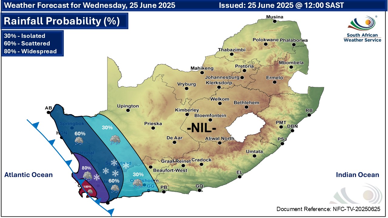
A newer forecast is available by clicking here. According to the SA Weather Service, an intense cold front is expected to make landfall on Wednesday over the south-western parts of South Africa, bringing a significant shift in weather conditions across the region until Friday and resulting in impacts such as: • Heavy rainfall with a risk of localised flooding over the western parts of the Western Cape, especially in low-lying and poorly drained areas on Wednesday into Thursday. • Wet and slippery roads may result in dangerous driving conditions. • Strong and gusty winds over the interior may cause localised damage to structures and uproot trees. • Cold to very cold conditions can be expected, along with possible snowfall over the western mountain ranges of the Western Cape, spreading into the south-western interior of the Northern Cape. • Gale force winds and very rough seas, with wave heights between 5.5 to 7.5 metres, along the coastlines of the Northern Cape and Western Cape, will lead to disruptions to fishing and port operations, an increased risk of vessels capsizing, accidents at sea, and hazardous shoreline conditions. As the system progresses eastwards it will affect the Eastern Cape, a region already vulnerable to weather-related impacts, bringing strong damaging winds on Thursday. Interior winds are expected to pick up and spread over the remainder of eastern provinces on Thursday and Friday bringing low daytime temperatures. An intense cold front will be passing through the Eastern Cape on Thursday. The public and small stock farmers are advised that snow, cold to very cold and windy conditions as well as very rough seas can be expected in places over the Eastern Cape. ALSO READ: More snowfall from Wednesday – four SA provinces, Lesotho and Namibia. Warnings from the SA Weather for Wednesday: A. level 4 warning for damaging waves resulting in the damage to coastal infrastructure and disruption to beach front activities along the coast between Alexander Bay and Cape Agulhas from Wednesday evening spreading to Plettenberg Bay by Thursday. B. level 2 warning for damaging coastal winds leading to difficulty in navigation at sea and localised disruption to small ports and coastal towns between Lambert's Bay and Cape Agulhas on Wednesday, spreading to Plettenberg Bay by Thursday. C. level 2 warning for damaging interior winds leading to localised problems for high-sided vehicles on prone routes and some transport services affected by wind over the western and northern parts of the Western Cape, Northern Cape as well as the western parts of the North West province and Free State. D. level 2 warning for disruptive rainfall leading to localised flooding of susceptible formal and informal settlements or roads, and low-lying areas over Cederberg, City of Cape Town, Cape Winelands, and the western parts of the Overberg district (Western Cape). Extremely high fire danger conditions are expected over the eastern parts of Northern Cape, the western parts of both North West and Free State, Beaufort West municipality of Western Cape as well as most places of the western parts of the Eastern Cape. Warnings from the SA Weather for Thursday: A. level 4 warning for damaging waves as per the map below. B. level 2 warning for damaging coastal winds as per the map below. C. level 2 warning for damaging waves as per the map below. D. level 2 warning for damaging interior winds as per the map below. E. level 2 warning for disruptive rainfall as per the map below. F. level 1 warning for disruptive snowfall resulting in traffic disruptions due to icy roads, and isolated cases of loss of vulnerable livestock and crops over Senqu and Elundini local municipalities. Regional forecasts from SAWS for Wednesday: 1. GAUTENG Fine and cool. The expected UVB sunburn index: High 2. MPUMALANGA Morning fog patches over the Lowveld and northern-western Highveld, otherwise fine and cold to cool but warm over the Lowveld. 3. LIMPOPO Morning fog patches over the Lowveld and adjacent escarpment, otherwise fine and cool to warm. 4. NORTH-WEST PROVINCE Fine, windy and cool. 5. FREE STATE Fine, windy and cool but cold around the Lesotho border. 6. NORTHERN CAPE Cloudy with scattered showers in the extreme west, otherwise partly cloudy with isolated showers and cold to cool, but fine in the north-west where it will be warm. The wind along the coast will be strong to gale force northerly to north-westerly. 7. WESTERN CAPE Fine over the eastern parts in the morning where it will be cool to warm, otherwise cloudy, windy and cold with isolated to scattered showers and rain but but widespread in the west. The wind along the coast will be strong to gale force northerly to north-westerly but moderate to fresh along the south coast. The expected UVB sunburn index: Low 8. WESTERN HALF OF THE EASTERN CAPE Fine, windy and warm, but cool in the south-west corner, becoming partly cloudy. The wind along the coast will be light to moderate north-westerly, becoming south-westerly. 9. EASTERN HALF OF THE EASTERN CAPE Fine, windy and cool to warm. The wind along the coast will be light to moderate northerly, becoming light south-westerly at night. 10. KWAZULU-NATAL Fine and cool but warm in the east. The wind along the coast will be light to moderate north-westerly but fresh in the north, becoming northerly to north-easterly by mid-morning. The expected UVB sunburn index: Very High Travellers forecasts from SAWS for Wednesday: PRETORIA Fine. Minimum/Maximum: 04/20°C The expected UVB Sunburn Index: High JOHANNESBURG Fine. Minimum/Maximum: 04/19°C VEREENIGING Fine. Minimum/Maximum: 01/20°C MBOMBELA Fine. Minimum/Maximum: 08/23°C POLOKWANE Fine. Minimum/Maximum: 06/21°C MAHIKENG Fine and windy. Minimum/Maximum: 6/21°C VRYBURG Fine and windy. Minimum/Maximum: 5/22°C BLOEMFONTEIN Fine and windy. Minimum/Maximum: 3/21°C KIMBERLEY Fine and windy. Minimum/Maximum: 6/23°C UPINGTON Partly cloudy and windy. Minimum/Maximum: 10/26°C CAPE TOWN Cloudy with widespread showers and rain (100%). Wind: Fresh to strong northerly to north-westerly. Minimum/Maximum: 12/14°C The expected UVB Sunburn Index: Low GEORGE Fine, becoming cloudy in the evening with isolated showers and rain. Wind: Light northerly, becoming moderate north-westerly in the evening. Minimum/Maximum: 9/22°C GQEBERHA Fine. Wind: Light to moderate north-westerly, becoming south-westerly. Minimum/Maximum: 13/27°C EAST LONDON Fine. Wind: Light to moderate northerly, becoming light south-westerly at night. Minimum/Maximum: 13/30°C DURBAN Fine. Wind: Light north-westerly until mid-morning and in the evening, otherwise northerly to north-easterly. Minimum/Maximum: 14/25°C The expected UVB Sunburn Index: Very High RICHARDS BAY Fine. Wind: Moderate to fresh northerly. Minimum/Maximum: 15/28°C PIETERMARITZBURG Fine. Minimum/Maximum: 6/26°C This forecast is usually updated a few times per day.
Please be sure to send photos and videos to us via whatsapp and also tell us where and when they were taken. Follow our channels
Maps for Thursday 26 June
   Maps for Friday 27 June

|