
    Swipe left or right for more maps, and see below for others
Level 5 severe thunderstorms with flooding and other warnings continue into ThursdayBy Staff WriterPublished: 23 April 2025 [updated 24 April] This forecast is for: Thu 24 April 2025 The maps cover: Thu 24 Apr – Sat 26 Apr
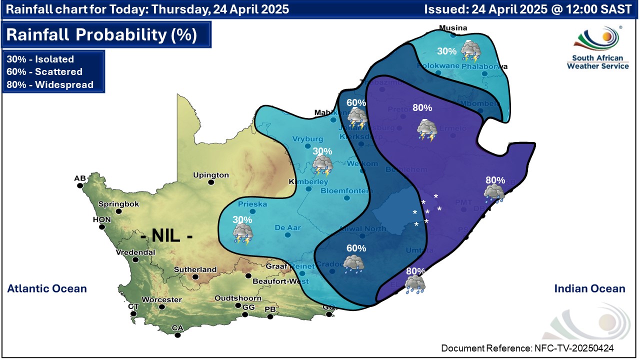
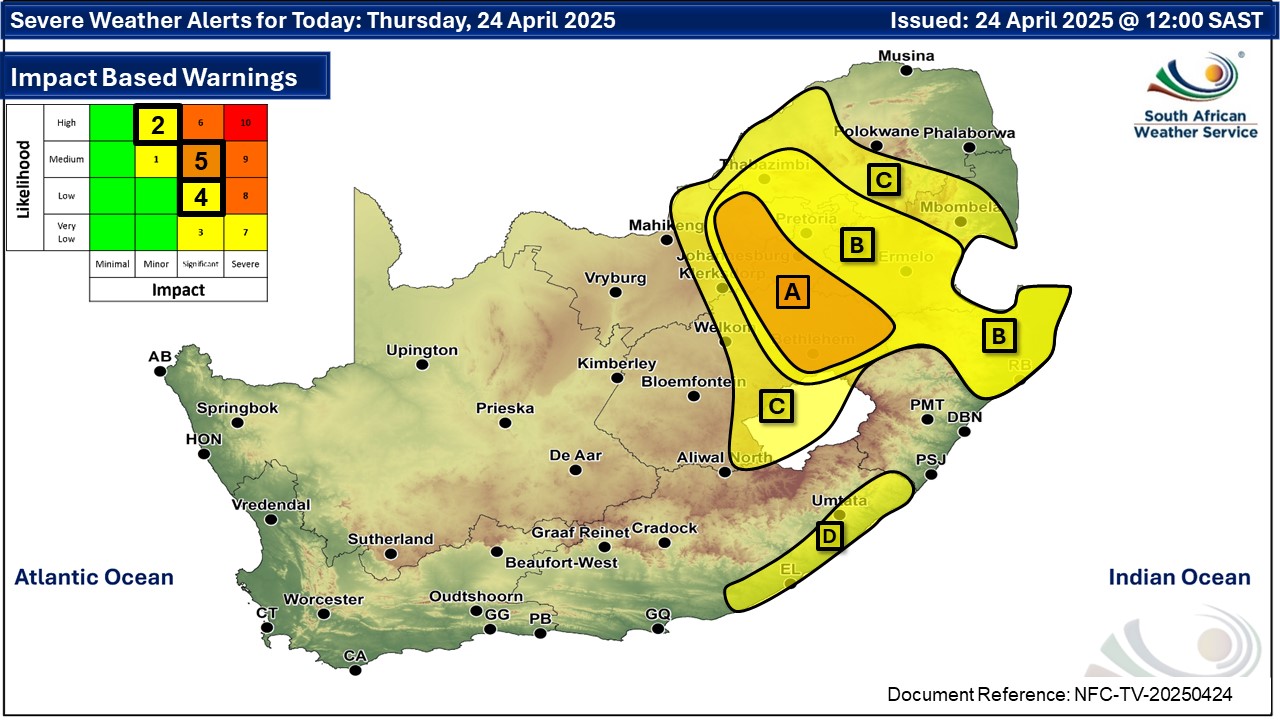
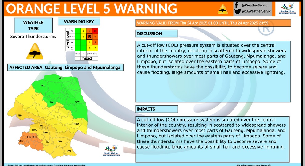
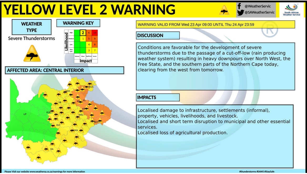
A newer forecast is available by clicking here. A cut-off low pressure system is situated over the central interior of the country, resulting in scattered to widespread showers and thundershowers over most parts of Gauteng, Mpumalanga, and Limpopo, but isolated over the eastern parts of Limpopo. Cold and wet conditions can be expected over the central and western parts of KwaZulu-Natal until Thursday, but very cold over the south-western high grounds. SEE PHOTOS: Snow falls in Lesotho this week. Daytime temperatures are also expected to drop significantly across most parts of the country from Wednesday onwards, with a gradual recovery from Friday onwards. Warnings from the SA Weather Service for Thursday: A. orange level 5 warning for severe thunderstorms resulting in heavy downpours leading to flooding of roads and bridges, damage to infrastructure and agricultural activities over the eastern parts of Free State, extreme east of the North West, southern parts of Gauteng and extreme south-western parts of Mpumalanga. B. yellow level 4 warning severe thunderstorms resulting in heavy downpours leading to localized flooding of roads and bridges, large amounts of small hail and excessive lightning over the extreme south-central parts of Limpopo, northern parts of Gauteng and Mpumalanga highveld as as over the northern and north-eastern parts of KwaZulu-Natal. C. yellow level 2 warning severe thunderstorms leading to localized damage to settlements, localized flooding of susceptible roads, low-lying areas and bridges over the central part of Free State, eastern parts of North West, southern parts of Limpopo and north-eastern parts of Mpumalanga, except in the north-eastern Lowveld. D. yellow level 2 warning for disruptive rain leading to localised flooding of settlements, roads and bridges in places along the coast and adjacent interior of the eastern half of the Eastern Cape. Regional forecasts from SAWS for Thursday: 1. GAUTENG Cloudy and cool with widespread showers and thundershowers. The expected UVB sunburn index: Moderate 2. MPUMALANGA Cloudy and cool to cold with scattered to widespread showers and thundershowers, but isolated in the Lowveld where it will be warm. 3. LIMPOPO Cloudy and cool isolated to scattered showers and thundershowers, but widespread in the south-west. It will be warm in the Lowveld and Limpopo Valley. 4. NORTH-WEST PROVINCE Cloudy and cool with isolated to scattered showers and thundershowers but widespread over the extreme eastern parts. 5. FREE STATE Cloudy and cool with isolated to scattered showers and thundershowers but widespread over the eastern half. It will cold along Lesotho border. 6. NORTHERN CAPE Morning and evening fog in places along coast, otherwise partly cloudy and cool with isolated thundershowers over the eastern parts, but fine over the north-western parts. The wind along the coast will be light and variable, becoming moderate to fresh southerly to south-easterly from the afternoon. 7. WESTERN CAPE Morning fog in places, otherwise partly cloudy and cool. It will be warm over the western interior. The wind along the coast will be light and variable in the morning, otherwise light to moderate southerly to south-easterly but light to moderate south-westerly along the west coast in the afternoon. The expected UVB sunburn index: High 8. WESTERN HALF OF THE EASTERN CAPE Cloudy and cool with isolated showers and rain but scattered showers and thundershowers in the east. The wind along the coast will be moderate to fresh easterly but light westerly west of Cannon Rock in the morning. 9. EASTERN HALF OF THE EASTERN CAPE Cloudy and cool to cold with scattered showers and rain, but widespread along the coast. The wind along the coast will be Light to moderate north-easterly but fresh in places. 10. KWAZULU-NATAL Cloudy and cool to cold with widespread showers and thundershowers. Light snow is possible in the south-western high grounds. The wind along the coast will be light to moderate southerly to south-easterly, but light to moderate northerly to north-easterly south of Richards Bay, reaching fresh to strong in places. The expected UVB sunburn index: Low Travellers forecasts from SAWS for Thursday: PRETORIA Cloudy with widespread showers and thundershowers. Minimum/Maximum: 14/18°C The expected UVB Sunburn Index: Moderate JOHANNESBURG Cloudy with widespread showers and thundershowers. Minimum/Maximum: 12/16°C VEREENIGING Cloudy with widespread showers and thundershowers. Minimum/Maximum: 11/18°C MBOMBELA Cloudy with scattered showers and thundershowers. Minimum/Maximum: 17/18°C POLOKWANE Cloudy with isolated showers and thundershowers. Minimum/Maximum: 15/19°C MAHIKENG Cloudy with isolated showers and thundershowers. Minimum/Maximum: 12/21°C VRYBURG Cloudy with isolated showers and thundershowers. Minimum/Maximum: 11/20°C BLOEMFONTEIN Cloudy with isolated showers and thundershowers. Minimum/Maximum: 11/18°C KIMBERLEY Cloudy with isolated showers and thundershowers. Minimum/Maximum: 12/19°C UPINGTON Fine. Minimum/Maximum: 10/21°C CAPE TOWN Partly cloudy. Wind: Light south-easterly. Minimum/Maximum: 15/24°C The expected UVB Sunburn Index: High GEORGE Partly cloudy with morning fog patches, becoming partly cloudy. Wind: Light and variable in the morning, otherwise light south-easterly. Minimum/Maximum: 11/19°C GQEBERHA Cloudy with isolated showers and rain. Wind: Light easterly. Minimum/Maximum: 16/21°C EAST LONDON Cloudy with widespread showers and rain. Wind: Light to moderate easterly. Minimum/Maximum: 17/20°C DURBAN Cloudy with widespread showers and thundershowers. Wind: Light to moderate easterly to south-easterly. Minimum/Maximum: 18/22°C The expected UVB Sunburn Index: Low RICHARDS BAY Cloudy with widespread showers and thundershowers. Wind: Light to moderate easterly to south-easterly. Minimum/Maximum: 18/21°C PIETERMARITZBURG Cloudy with widespread showers and thundershowers. Minimum/Maximum: 13/17°C This forecast is usually updated a few times per day.
Please be sure to send photos and videos to us via whatsapp and also tell us where and when they were taken. Follow our channels
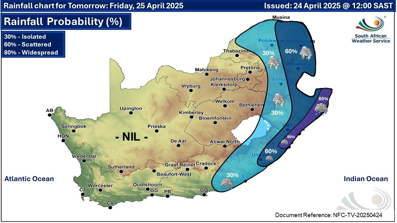
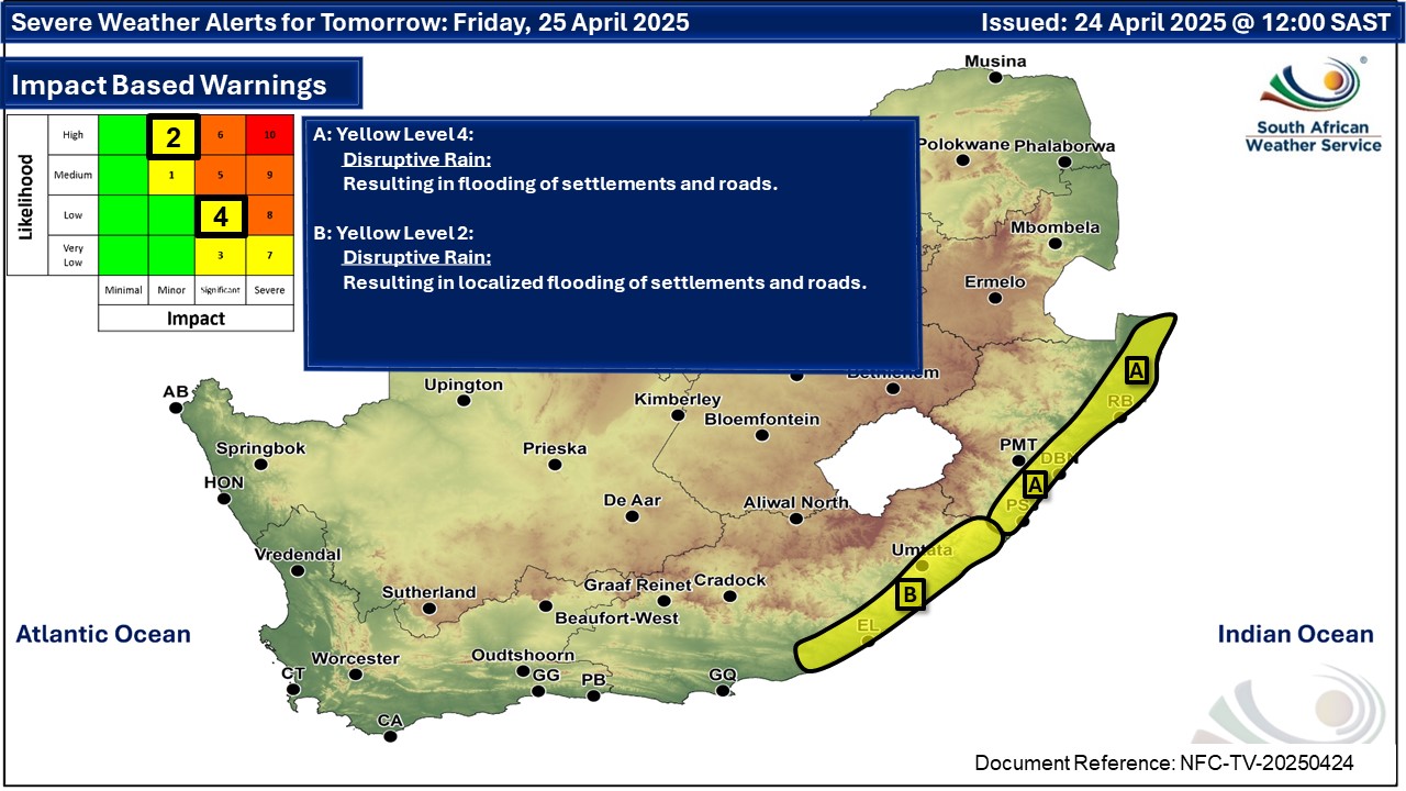
Maps for Friday 25 April
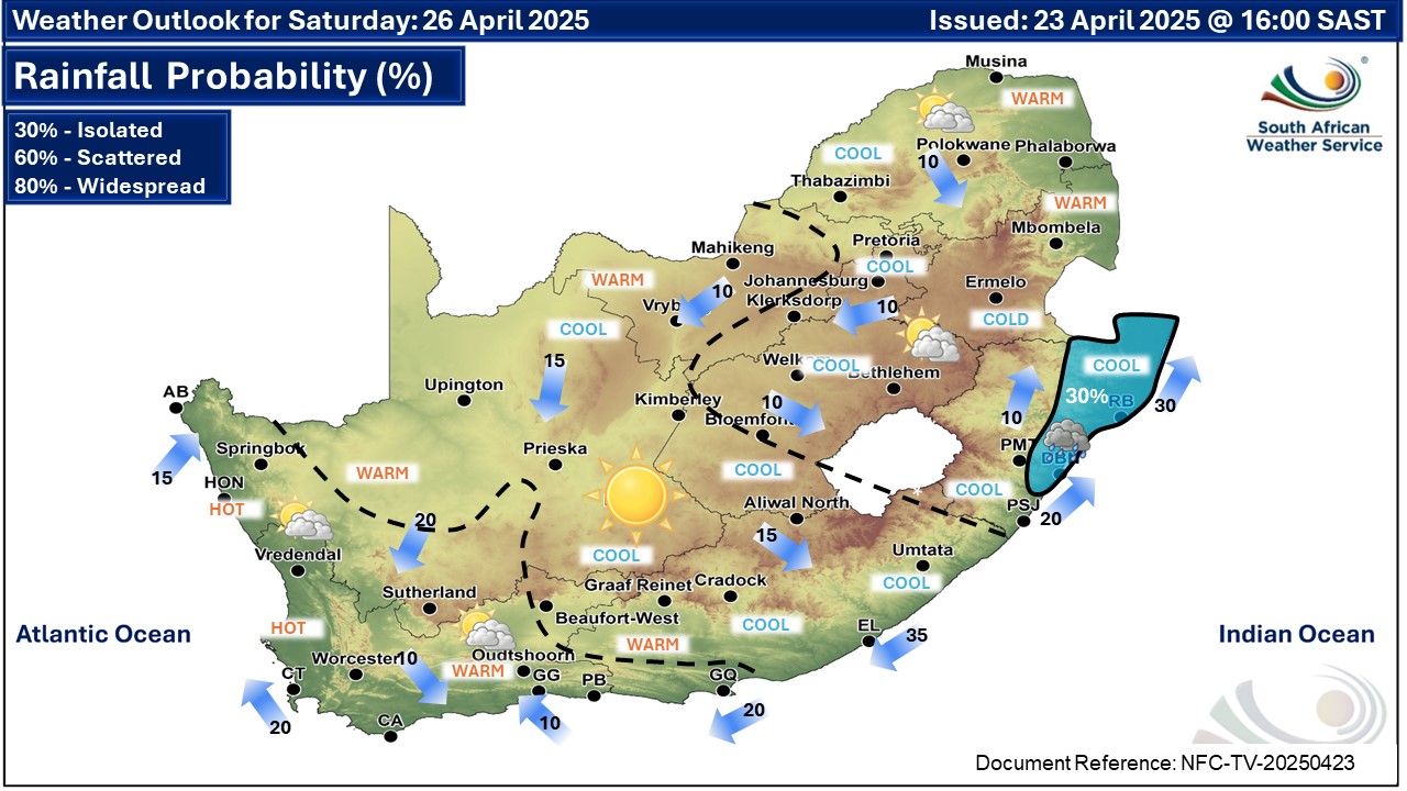
  Maps for Saturday 26 April
|