
THURSDAY WEATHER: Cold, wet, windy conditions with three warnings including disruptive snowfall
By Staff WriterPublished: 1 July 2026 [updated 2 July]
This forecast is for: Thu 02 July 2026
The maps cover: Thu 02 Jul – Thu 02 Jul
| SHARE TO |
The latest forecast is available by clicking here.
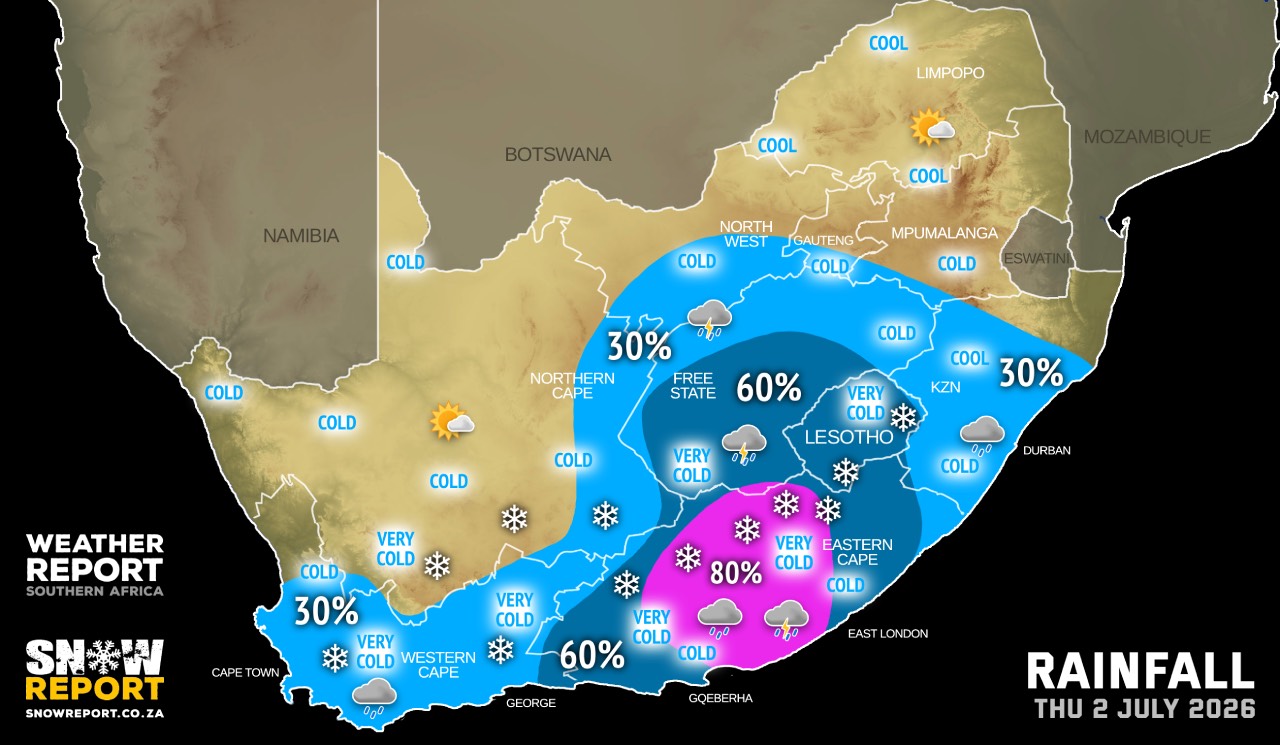
Very cold, wet and windy conditions can be expected on Thursday over the Free State, the southern parts of North West and most parts of the Northern Cape as well as in places over the Eastern Cape interior.
SEE ALSO: Disruptive snow on the radar for Thursday.
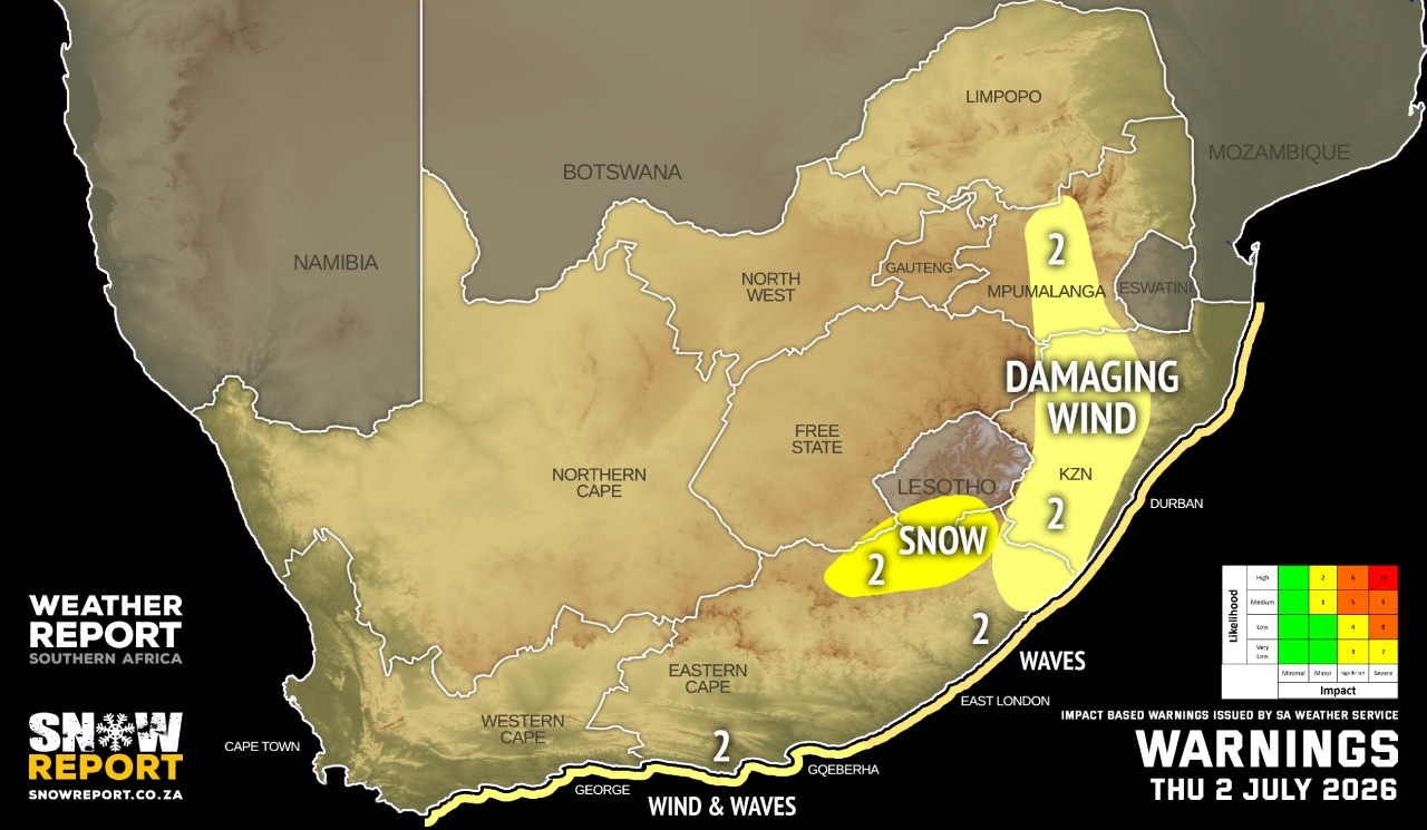
Warnings from the SA Weather Service:
A. level 1 warning for severe thunderstorms with heavy downpours resulting in localised flooding of low-lying areas, roads and bridges as well as hail and damaging winds which will lead to damage to settlements and infrastructure over the central and eastern parts of the Eastern Cape, except in the extreme north-east.
B. level 2 warning for disruptive snow resulting in localised traffic disruption over the north-eastern parts of Eastern Cape (near the Lesotho border).
C. level 2 warning for damaging winds between Cape Point and Plettenberg Bay.
D. level 2 warning for damaging waves between Plettenberg Bay and Port Edward.
Regional forecasts from the SA Weather Service:
GAUTENG
Cold in the south, otherwise partly cloudy and cool with light isolated showers and rain in the extreme south.
MPUMALANGA
Cloudy with a chance of light rain and showers in the extreme south-west, otherwise partly cloudy and cool but cold in the extreme Highveld. It will be fine and warm in the Lowveld.
LIMPOPO
Fine and cool to warm.
NORTH WEST
Cool in the extreme east, otherwise partly cloudy, windy and cold with isolated morning showers and rain over the southern parts.
THE FREE STATE
Cloudy in the west, otherwise partly cloudy, windy and cold to very cold with isolated showers and rain in the morning but scattered in the south. It will become fine in the afternoon.
THE NORTHERN CAPE
Cloudy with morning fog in the west, otherwise partly cloudy, windy and cold to very cold with isolated morning showers and rain in the extreme east. It will becoming fine in the west by the afternoon. The wind along the coast will be light to moderate northerly to north-westerly, becoming south-easterly from the evening.
THE WESTERN CAPE
Cloudy and cold with isolated showers and rain, except in the north-west. Partially clearance is expected from the afternoon in the north and north-eastern parts. The wind along the coast will be moderate to fresh westerly to north-westerly, but strong to gale south-westerly along the south coast in the morning.
THE WESTERN HALF OF THE EASTERN CAPE
Light snow over the northern high ground, otherwise cloudy, windy and very cold with scattered showers and thundershowers, but widespread in the east. It will become fine in the evening, but partly cloudy along the coast. The wind along the coast will be fresh to strong south-westerly, reaching gale force in places from the afternoon.
THE EASTERN HALF OF THE EASTERN CAPE
Very cold with snow over the northern high ground, otherwise cloudy, windy and cold to cool with scattered showers and thundershowers, but widespread in the west. It will become fine in the evening. The wind along the coast will be fresh to strong south-westerly, reaching gale force in places from the afternoon.
KWAZULU-NATAL
Partly cloudy and cool with isolated showers and thundershowers, except in the north-east where it will be warm. The wind along the coast is moderate to fresh north-easterly north of Durban, but moderate to fresh south-westerly in the south and strong at times, spreading northwards.
Travellers forecasts from the SA Weather Service:
PRETORIA
Partly cloudy becoming fine in the afternoon.
Minimum/Maximum: 9/18°C
JOHANNESBURG
Partly cloudy becoming fine in the afternoon.
Minimum/Maximum: 9/15°C
VEREENIGING
Partly cloudy with isolated light showers and rain.
Minimum/Maximum: 12/13°C
MBOMBELA
Partly cloudy.
Minimum/Maximum: 8/25°C
POLOKWANE
Fine.
Minimum/Maximum: 5/24°C
MAHIKENG
Partly cloudy becoming fine in the afternoon.
Minimum/Maximum: 9/15°C
VRYBURG
Partly cloudy in the morning, otherwise fine.
Minimum/Maximum: 4/14°C
BLOEMFONTEIN
Partly cloudy, windy with scattered morning showers and rain.
Minimum/Maximum: 3/10°C
KIMBERLEY
Cloudy with isolated showers and rain in the morning.
Minimum/Maximum: 1/11°C
UPINGTON
Cloudy becoming fine from the afternoon.
Minimum/Maximum: 3/11°C
CAPE TOWN
Cloudy with isolated showers and rain in the morning and evening.
Wind: Light and variable, becoming moderate to fresh north-westerly from mid-morning.
Minimum/Maximum: 9/14°C
GEORGE
Cloudy with isolated light showers and rain.
Wind: Moderate to fresh westerly to north-westerly.
Minimum/Maximum: 9/16°C
GQEBERHA
Cloudy with scattered showers and thundershowers.
Wind: Fresh to strong south-westerly, reaching gale force at times from the afternoon.
Minimum/Maximum: 11/17°C
KuGOMPO CITY
Cloudy with scattered showers and thundershowers.
Wind: Fresh to strong south-westerly, reaching gale force at times from the afternoon.
Minimum/Maximum: 11/18°C
DURBAN
Partly cloudy with isolated showers and thundershowers.
Wind: Moderate to fresh south-westerly, becoming strong in the afternoon.
Minimum/Maximum: 18/22°C
RICHARDS BAY
Partly cloudy with isolated showers and thundershowers.
Wind: Moderate to fresh north-easterly in the morning, otherwise moderate to fresh south-westerly.
Minimum/Maximum: 15/31°C
PIETERMARITZBURG
Partly cloudy with isolated showers and thundershowers.
Minimum/Maximum: 9/23°C
This forecast is usually updated a few times per day.
| SHARE TO |
Please be sure to send photos and videos to us via whatsapp and also tell us where and when they were taken.
Follow our channels