
     Swipe left or right for more maps, and see below for others
Orange level 5 warning for Gauteng and thunderstorm warnings for six provinces on Sunday due to cut-off lowBy Staff WriterPublished: 18 October 2025 [updated 19 October] This forecast is for: Sun 19 October 2025 The maps cover: Sun 19 Oct – Tue 21 Oct
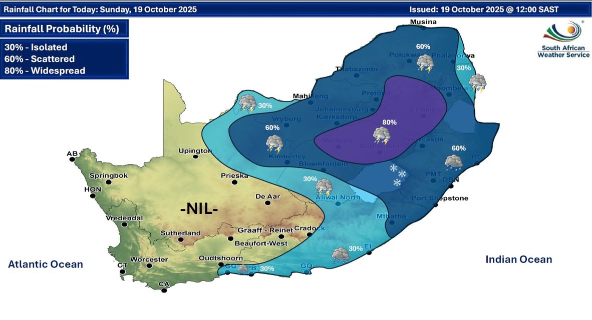
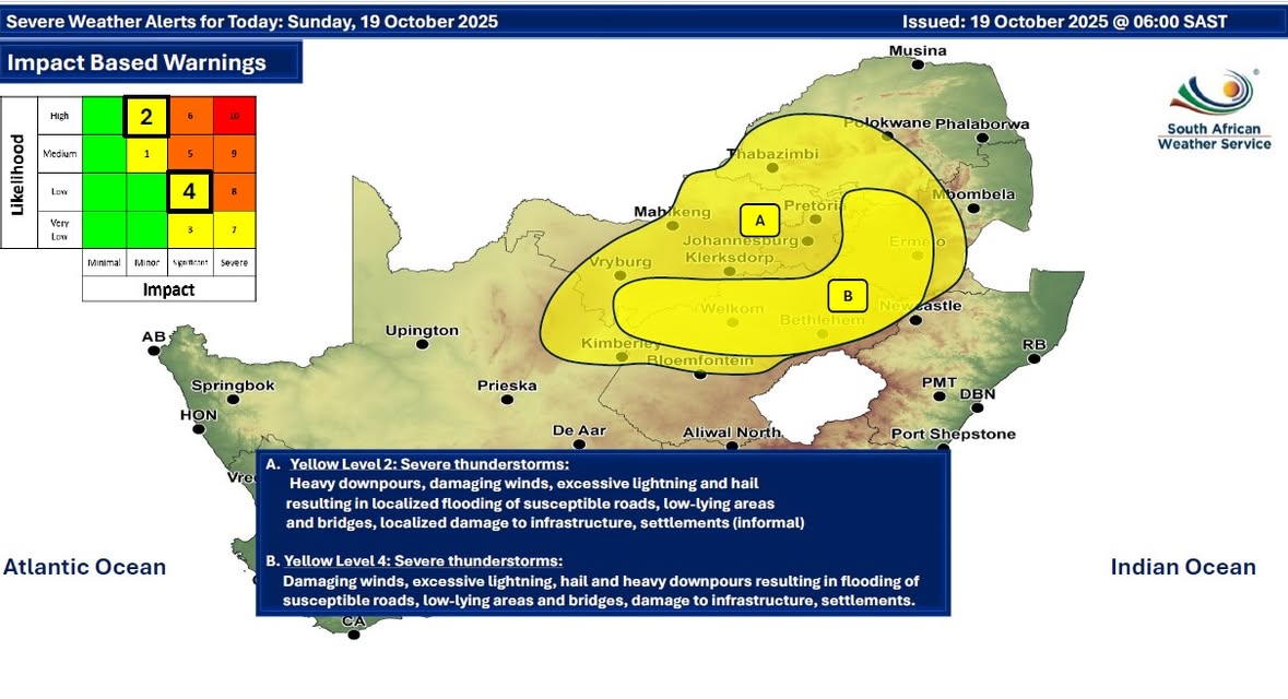
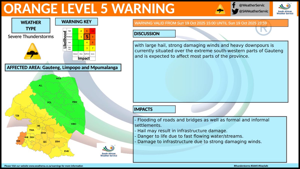
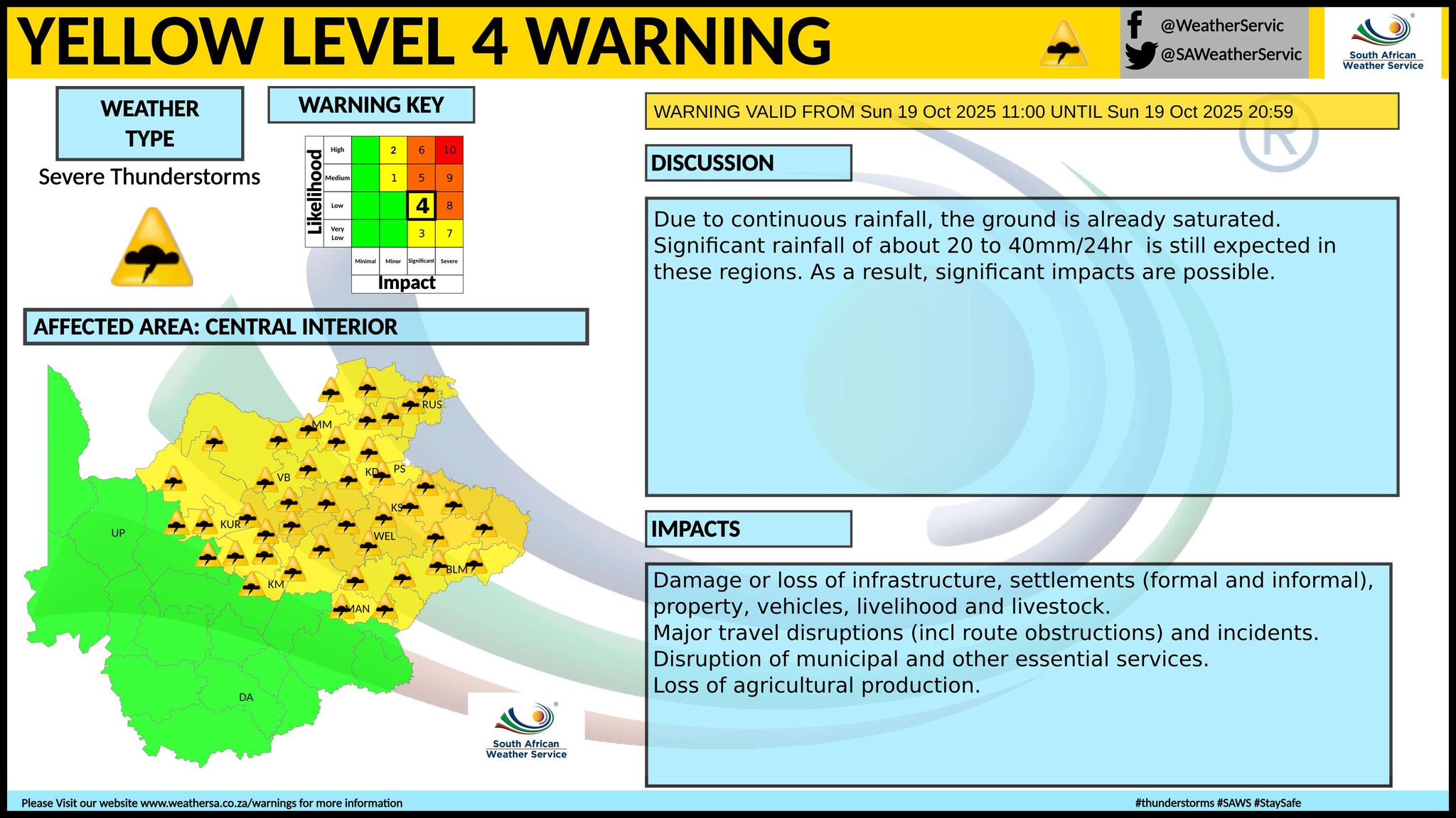
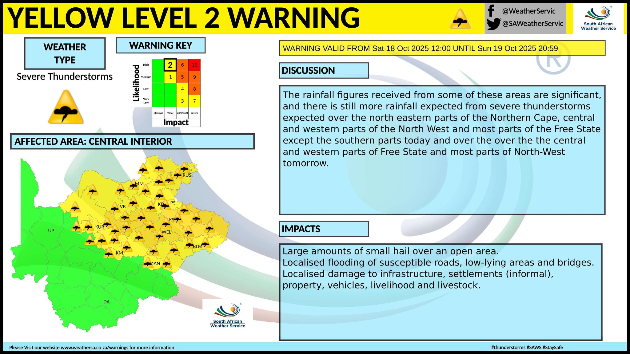
The latest forecast is available by clicking here. A cut-off low (COL) pressure system is situated over the central interior of the country on Sunday, resulting in scattered to widespread showers and thundershowers over most parts of Gauteng, Mpumalanga, and Limpopo, but isolated over the eastern parts of Limpopo. Some of these thunderstorms have the possibility to become severe and cause flooding, large amounts of small hail and excessive lightning, as well as strong damaging winds. Scattered to widespread showers and thundershowers are possible over the central and eastern parts of the country by the afternoon, and snowfall possible in some of the mountains bordering Lesotho. Rainfall of between 20mm and 40mm in possible in places, possibly resulting in significant impacts as the ground is already saturated. Major travel disruptions are possible. From Monday it should be partly cloudy and cool to warm conditions over the central and eastern parts of the country, with isolated to scattered showers and thundershowers possible by the afternoon. It will be cold in places in the eastern half of the Eastern Cape, according to the SA Weather Service. ALSO READ: More snowfall possible for Lesotho and the Drakensberg from Saturday until Tuesday (18-21 October). Warnings from the SA Weather Service for Sunday: level 5 warning for severe thunderstorms with large hail, strong damaging winds and heavy downpours is currently situated over the extreme south-western parts of Gauteng and is expected to affect most parts of the province. Possible impacts include flooding of roads and bridges as well as formal and informal settlements, infrastructure damage due to hail and strong winds. SA Weather's warning includes danger to life due to fast flowing water/streams. A. level 2 warning for severe thunderstorms resulting in localised damage to infrastructure, settlements (informal), property, vehicles, livelihood and livestock, as well as localised flooding of susceptible roads, low-lying areas and bridges are expected over Gauteng, North West, south-western parts Limpopo, the Highveld of Mpumalanga, north eastern parts of the Northern Cape as well as most parts of the Free State, except the extreme south. B. level 4 warning for severe thunderstorms leading to flooding of roads, settlements and low-lying areas, resulting in closure of some bridges and roads as well as loss of agricultural production are expected over the northern and the eastern parts of Free State, the extreme south-western parts of North West as well as the eastern Highveld of Mpumalanga. Regional forecasts from the SA Weather Service for Sunday: GAUTENG Partly cloudy and warm becoming cloudy with widespread afternoon showers and thundershowers but scattered in the west. The expected UVB sunburn index: Low MPUMALANGA Cloudy and cool to warm with isolated to scattered showers and thundershowers, but widespread over the Highveld. LIMPOPO Cloudy and cool to warm with isolated to scattered showers and thundershowers, but widespread over the extreme south-central parts. 4. NORTH WEST Cloudy in the east, otherwise partly cloudy and warm, with scattered showers and thundershowers. THE FREE STATE Cloudy and cool to warm with scattered to widespread showers and thundershowers but isolated over the south-western parts. THE NORTHERN CAPE Fine in the west, otherwise partly cloudy and warm with isolated showers and thundershowers in the north-east but scattered in the extreme north-east. The wind along the coast will be fresh to strong south to south-easterly. THE WESTERN CAPE Hot in places along the West Coast, otherwise fine, windy and warm, but cloudy and cool along the south coast with a chance of light rain east of Riversdale from late morning until early afternoon. The wind along the coast will be fresh to strong south to south-easterly, but moderate along the south coast in the morning where it will become easterly in the afternoon. The expected UVB sunburn index: Very High THE WESTERN HALF OF THE EASTERN CAPE Fine and cool but cloudy along the coast and adjacent interior with isolated light rain and showers. The wind along the coast will be light south-easterly, becoming easterly by evening. THE EASTERN HALF OF THE EASTERN CAPE Cloudy and cool to cold with isolated showers and rain but scattered in the east. The wind along the coast will be light to moderate south-westerly, becoming south-easterly in the afternoon. KWAZULU-NATAL Morning fog patches over the southern interior, otherwise cloudy and cool to cold but very cold in the south-west. Scattered showers and thundershowers are expected. The wind along the coast will be moderate to fresh southerly to south-easterly. The expected UVB sunburn index: High Travellers forecasts from the SA Weather Service for Sunday: PRETORIA Partly cloudy becoming cloudy with scattered afternoon showers and thundershowers. Minimum/Maximum: 13/26°C The expected UVB Sunburn Index: Low JOHANNESBURG Partly cloudy becoming cloudy with scattered afternoon showers and thundershowers. Minimum/Maximum: 12/25°C VEREENIGING Partly cloudy becoming cloudy with widespread afternoon showers and thundershowers. Minimum/Maximum: 15/26°C MBOMBELA Partly cloudy in the morning, otherwise cloudy with isolated showers and thundershowers. Minimum/Maximum: 16/22°C POLOKWANE Cloudy with isolated showers and thundershowers. Minimum/Maximum: 16/25°C MAHIKENG Cloudy with scattered showers and thundershowers. Minimum/Maximum: 14/28°C VRYBURG Cloudy with scattered showers and thundershowers. Minimum/Maximum: 13/27°C BLOEMFONTEIN Cloudy with scattered showers and thundershowers. Minimum/Maximum: 12/25°C KIMBERLEY Partly cloudy with scattered showers and thundershowers. Minimum/Maximum: 13/27°C UPINGTON Partly cloudy becoming fine in the afternoon. Minimum/Maximum: 17/31°C CAPE TOWN Fine and windy. Wind: Fresh to strong south to south-easterly. Minimum/Maximum: 15/24°C The expected UVB Sunburn Index: Very High GEORGE Cloudy with a chance of light rain from mid-morning until early afternoon. Wind: Light north-westerly, becoming moderate south-east to easterly from late morning. Minimum/Maximum: 13/21°C GQEBERHA Cloudy with isolated morning showers, otherwise partly cloudy. Wind: Light south-westerly in the morning, otherwise light south-easterly, becoming easterly by evening. Minimum/Maximum: 15/19°C EAST LONDON Cloudy with isolated showers. Wind: Light to moderate south-westerly, becoming south-east by afternoon. Minimum/Maximum: 15/19°C DURBAN Cloudy with scattered showers and thundershowers. Wind: Moderate to fresh southerly to south-westerly becoming south-easterly from the morning. Minimum/Maximum: 18/20°C The expected UVB Sunburn Index: High RICHARDS BAY Cloudy with scattered showers and thundershowers. Wind: Moderate to fresh southerly to south-easterly. Minimum/Maximum: 17/22°C PIETERMARITZBURG Morning fog patches, otherwise cloudy with scattered showers and thundershowers. Minimum/Maximum: 12/15°C This forecast is usually updated a few times per day.
Please be sure to send photos and videos to us via whatsapp and also tell us where and when they were taken. Follow our channels
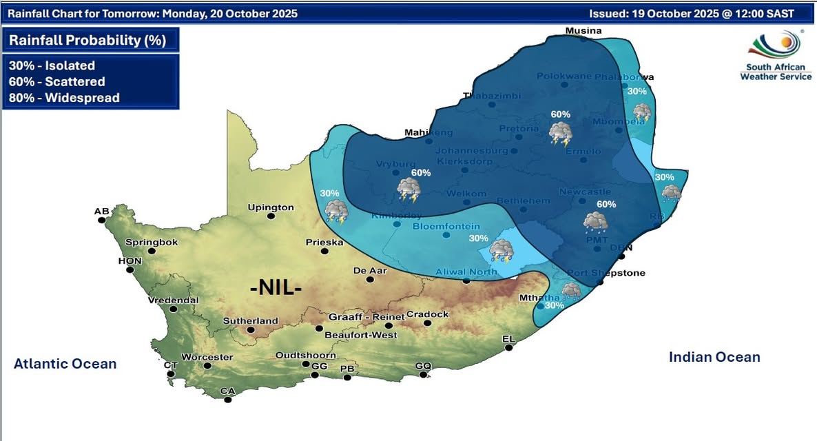
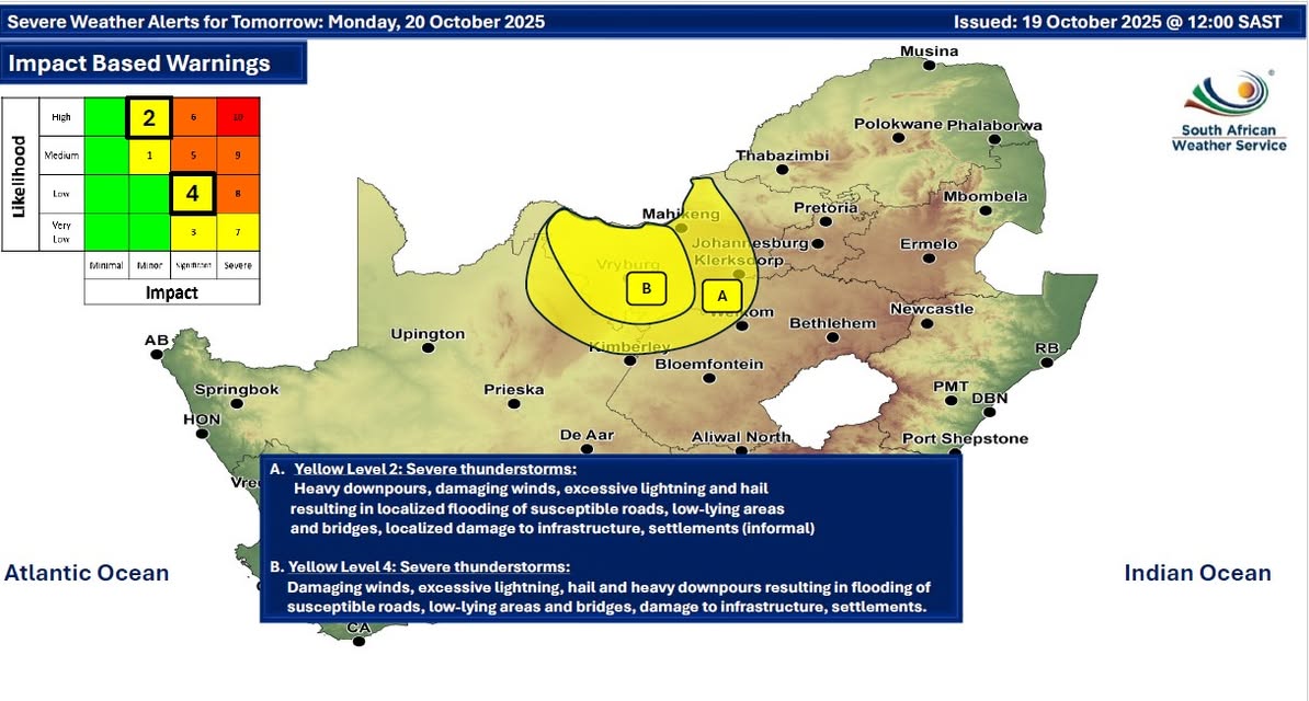
Maps for Monday 20 October
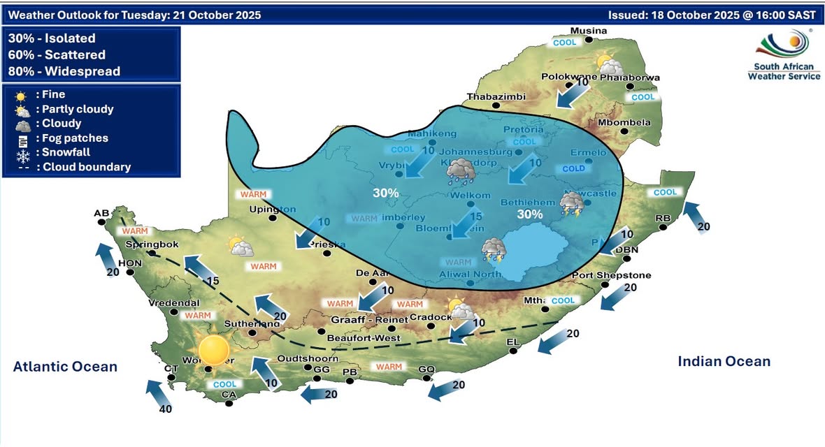
  Maps for Tuesday 21 October
|