
   Swipe left or right for more maps, and see below for others
A wet Saturday ahead with thunderstorm warnings covering four provincesBy Staff WriterPublished: 17 October 2025 [updated 18 October] This forecast is for: Sat 18 October 2025 The maps cover: Sat 18 Oct – Mon 20 Oct
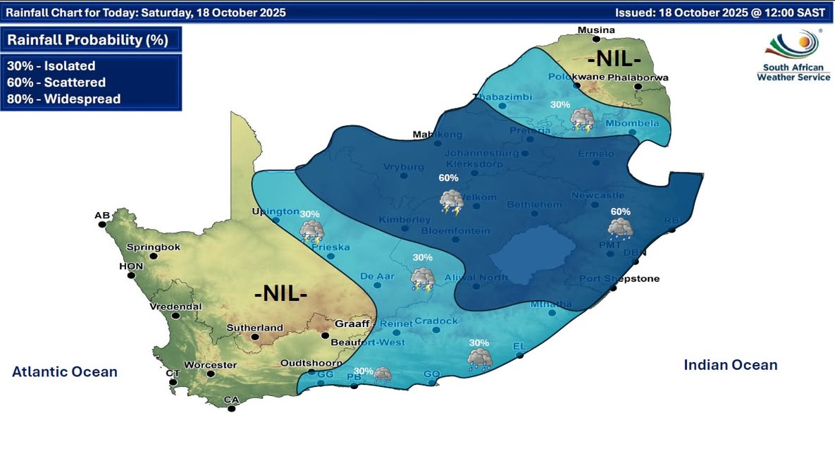
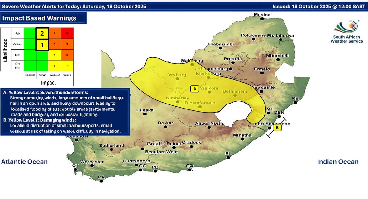
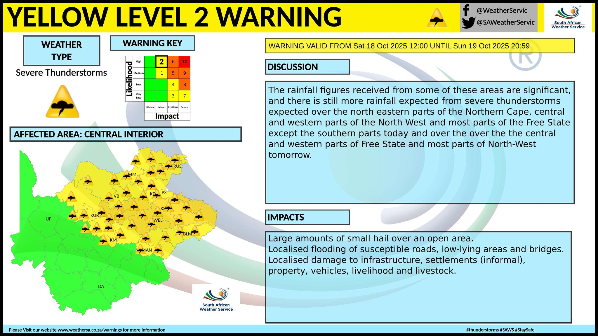
The latest forecast is available by clicking here. Fine over the western interior on Saturday, otherwise partly cloudy and cool to warm with isolated to scattered showers and thundershowers over the central and eastern parts of the country. Rain and showers can also be expected in places along the south coast and adjacent interior. Extremely uncomfortable conditions are expected over the extreme north-eastern parts of KwaZulu-Natal on Saturday. ALSO READ: More snowfall possible for Lesotho and the Drakensberg from Saturday until Tuesday (18-21 October). Warnings from the SA Weather Service for Saturday: A. level 2 warning for severe thunderstorms resulting in strong damaging winds, large amounts of small hail/large hail in an open area, and heavy downpours leading to localised flooding of susceptible areas (settlements, roads and bridges), and excessive lightning is expected over most parts of Free State, western parts of North West and KwaZulu-Natal, and north-eastern parts of the Northern Cape. B. level 1 warning for damaging winds resulting in localised disruption of small harbours/ports for a short period of time, small vessels at risk of taking on water and capsizing in a locality and difficulty in navigation are expected along the KwaZulu-Natal coast between Port Edward and Durban. Regional forecasts from the SA Weather Service for Saturday: GAUTENG Cloudy and cool to warm with isolated to scattered showers and thundershowers. The expected UVB sunburn index: High MPUMALANGA Partly cloudy in the Lowveld, otherwise cloudy and cool to warm with isolated showers and thundershowers but scattered in the south. LIMPOPO Cloudy in the south-west with isolated showers and thundershowers, otherwise partly cloudy and warm. 4. NORTH WEST Cloudy and warm with scattered showers and thundershowers but isolated in the east. THE FREE STATE Partly cloudy and cool to warm with scattered showers and thundershowers but isolated in the extreme south-west. THE NORTHERN CAPE Partly cloudy and warm to hot with isolated showers and thundershowers in the east. It will be fine in the west. The wind along the coast will be fresh to strong south-easterly. THE WESTERN CAPE Fine in the north-east, otherwise partly cloudy and cool to warm. It will be cloudy with isolated showers and rain along the south coast. The wind along the coast will be fresh to strong westerly to south-westerly. The expected UVB sunburn index: Very High THE WESTERN HALF OF THE EASTERN CAPE Partly cloudy and cool to warm, but cloudy and windy with isolated showers and rain in the south. Isolated thundershowers are expected in the north-east. The wind along the coast will be moderate to fresh south-westerly. THE EASTERN HALF OF THE EASTERN CAPE Cloudy, windy and cool to warm with isolated showers and thundershowers but scattered in the north and east. The wind along the coast will be fresh to strong south-westerly. KWAZULU-NATAL Cloudy and cool to warm with scattered showers and thundershowers. The wind along the coast will be moderate to fresh south-westerly, but light north-westerly in the north. The expected UVB sunburn index: Low Travellers forecasts from the SA Weather Service for Saturday: PRETORIA Cloudy with isolated showers and thundershowers. Minimum/Maximum: 14/23°C The expected UVB Sunburn Index: High JOHANNESBURG Cloudy with scattered showers and thundershowers. Minimum/Maximum: 12/20°C VEREENIGING Cloudy with scattered showers and thundershowers. Minimum/Maximum: 14/18°C MBOMBELA Partly cloudy in the morning, otherwise cloudy with isolated showers and thundershowers. Minimum/Maximum: 14/28°C POLOKWANE Partly cloudy with isolated showers and thundershowers. Minimum/Maximum: 13/27°C MAHIKENG Cloudy with scattered showers and thundershowers. Minimum/Maximum: 16/23°C VRYBURG Cloudy with scattered showers and thundershowers. Minimum/Maximum: 14/26°C SUTHERLAND Partly cloudy. Minimum/Maximum: 4/21°C BLOEMFONTEIN Partly cloudy with scattered showers and thundershowers. Minimum/Maximum: 16/25°C KIMBERLEY Partly cloudy with scattered showers and thundershowers. Minimum/Maximum: 16/26°C UPINGTON Partly cloudy with isolated showers and thundershowers. Minimum/Maximum: 19/30°C CAPE TOWN Partly cloudy. Wind: Fresh to strong south-westerly. Minimum/Maximum: 15/21°C The expected UVB Sunburn Index: Very High GEORGE Cloudy with isolated showers and rain. Wind: Moderate to fresh westerly to south-westerly. Minimum/Maximum: 12/20°C GQEBERHA Cloudy with isolated showers and rain. Wind: Fresh to strong south-westerly, moderating in the evening. Minimum/Maximum: 15/21°C EAST LONDON Cloudy with isolated showers and rain from the afternoon. Wind: Fresh to strong south-westerly. Minimum/Maximum: 15/24°C DURBAN Cloudy with scattered showers and thundershowers. Wind: Moderate to fresh south-westerly. Minimum/Maximum: 17/28°C The expected UVB Sunburn Index: Low RICHARDS BAY Cloudy with scattered showers and thundershowers. Wind: Light to moderate north-westerly. Minimum/Maximum: 18/28°C PIETERMARITZBURG Cloudy with scattered showers and thundershowers. Minimum/Maximum: 11/28°C This forecast is usually updated a few times per day.
Please be sure to send photos and videos to us via whatsapp and also tell us where and when they were taken. Follow our channels
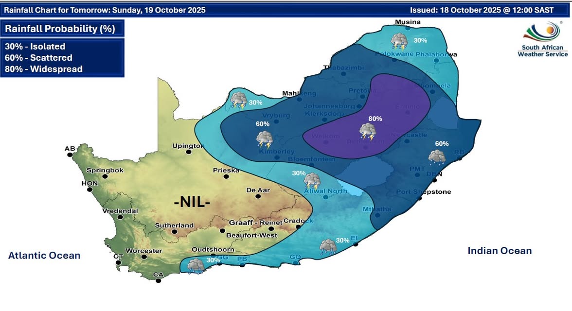
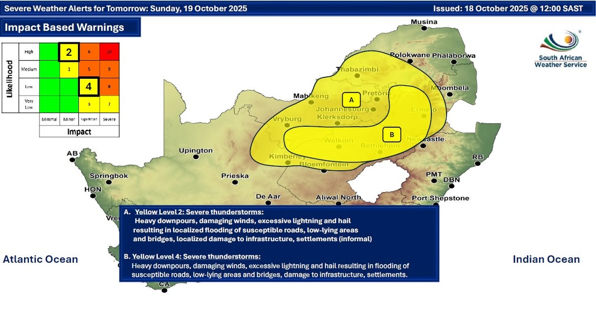
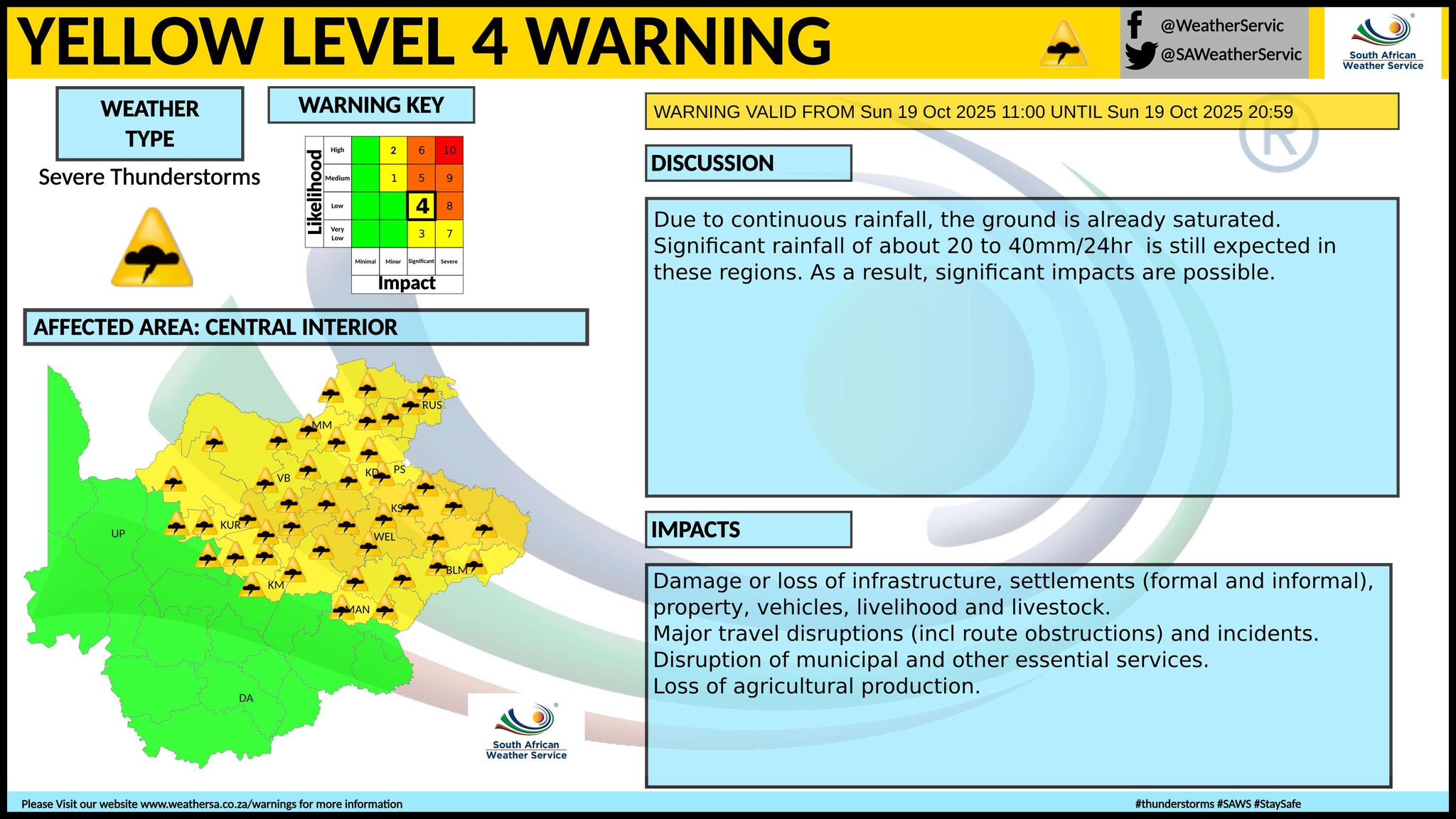
Maps for Sunday 19 October
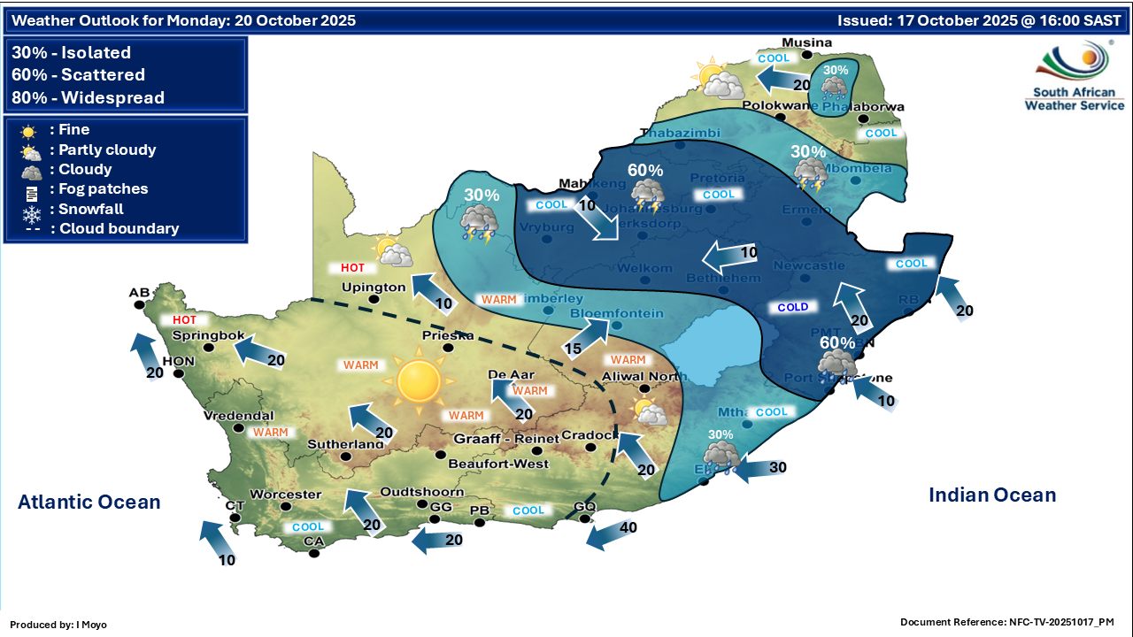
   Maps for Monday 20 October
|