
  Swipe left or right for more maps, and see below for others
A severe thunderstorm warning and damaging winds for Friday before a cold wet weekendBy Staff WriterPublished: 16 October 2025 [updated 17 October] This forecast is for: Fri 17 October 2025 The maps cover: Fri 17 Oct – Sun 19 Oct
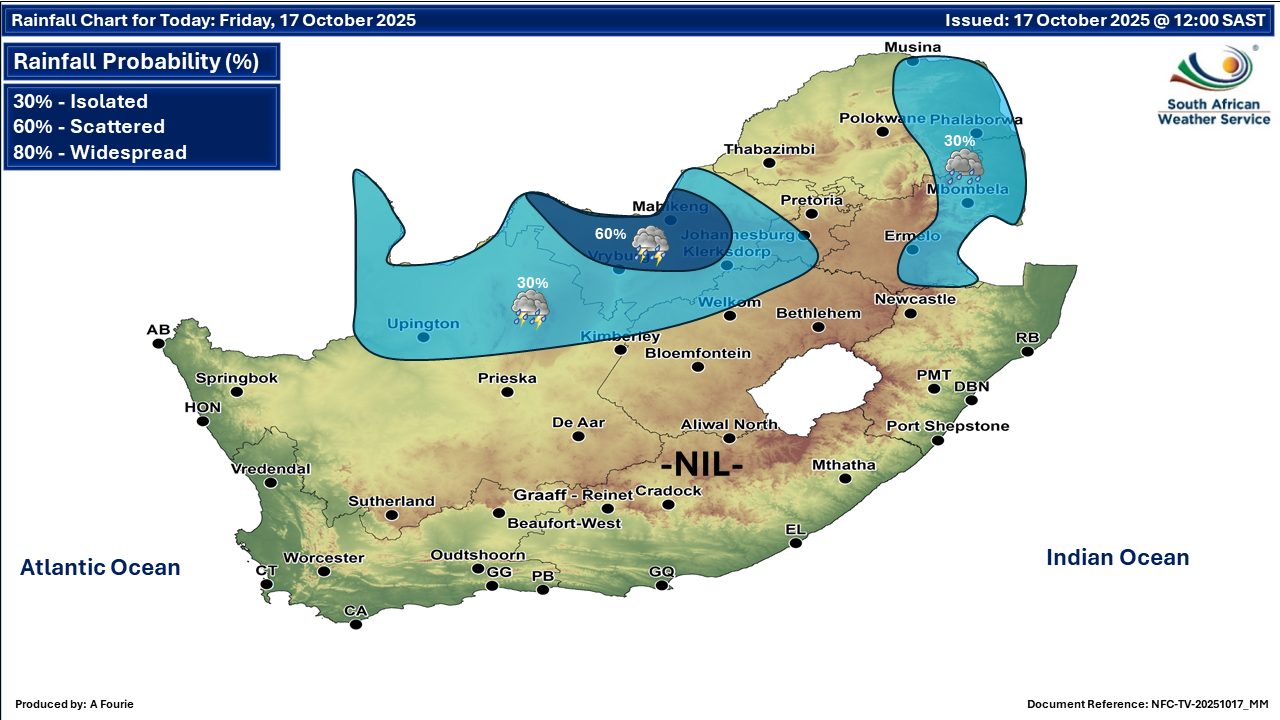
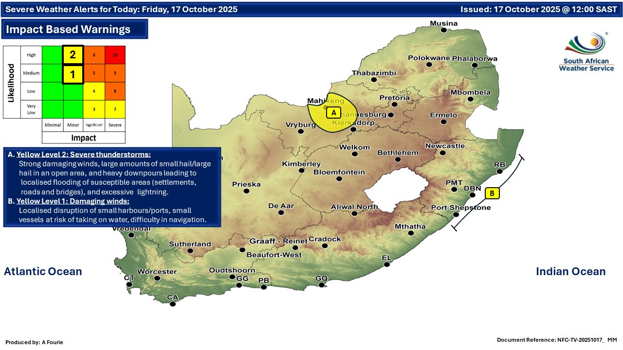
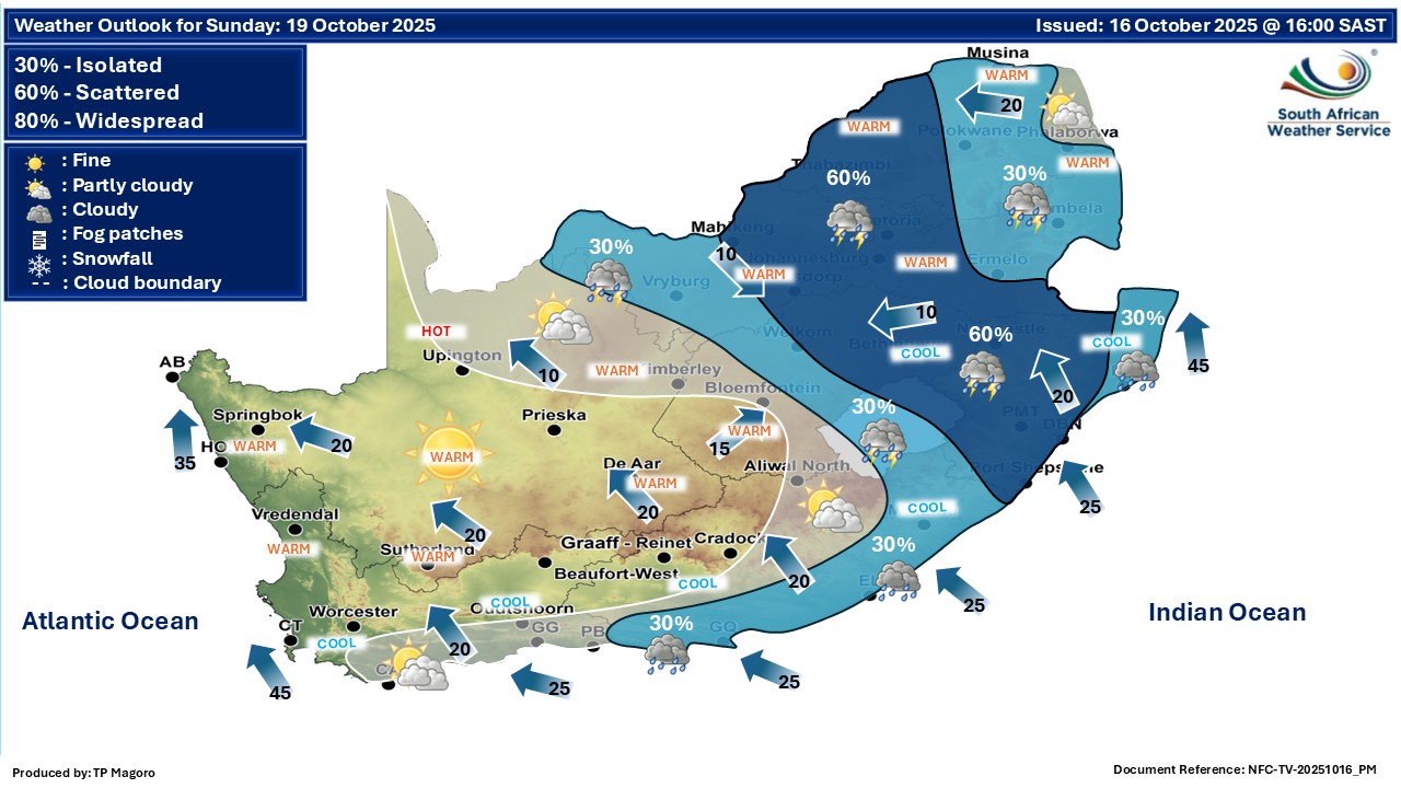
The latest forecast is available by clicking here. Isolated to scattered showers and thundershowers in the central and eastern parts of South Africa on Friday. From Saturday it should be fine over the western interior, otherwise partly cloudy and cool to warm with isolated to scattered showers and thundershowers over the central and eastern parts of the country. Rain and showers can also be expected in places along the south coast and adjacent interior. ALSO READ: More snowfall possible for Lesotho and the Drakensberg from Sunday until Tuesday (19-21 October). Warnings from the SA Weather Service for Friday: A. level 2 warning for severe thunderstorms with heavy downpours resulting in localized flooding of low-lying areas, bridges, large amounts of small hail, damaging winds, and excessive lightning over the central part of the North West. B. level 1 warning for damaging winds off the coast of KwaZulu-Natal, as per the map above. Extremely high fire danger conditions over the Northern Cape, the western and central part of the North West, the western part of the Free State, the north-western part of Eastern Cape and in places in the northern part of the Western Cape. Regional forecasts from the SA Weather Service for Friday: GAUTENG Partly cloudy and warm with isolated thundershowers in the south. The expected UVB sunburn index: High MPUMALANGA Cloudy in the east with light rain and drizzle in places until the afternoon, otherwise partly cloudy and cool with isolated showers and thundershowers in the extreme south-west. It will be cold in places along the escarpment. LIMPOPO Cloudy in the east with light rain and drizzle in places, otherwise partly cloudy and cool to warm. NORTH-WEST Fine in the east at first, otherwise partly cloudy and warm to hot , with isolated showers and thundershowers but scattered over the central parts. THE FREE STATE Morning fog patches in the extreme east, otherwise partly cloudy and warm to hot with isolated showers and thundershowers. THE NORTHERN CAPE Morning fog patches over the north-western interior where it will be cool, otherwise partly cloudy and warm to hot, but fine in the south. Isolated showers and thundershowers are expected over the central and the eastern part. The wind along the coast will be moderate to fresh south to south-easterly, but north-west to westerly from mid-morning until late afternoon. THE WESTERN CAPE Fine and warm to hot, becoming partly cloudy from the evening, but cloudy over the northern parts. It will be cool in places along the south coast. The wind along the coast will be fresh to strong east to south-easterly south of Cape Point and along the south coast, otherwise moderate to fresh south to south-westerly, spreading to the south coast by the evening. It will be light to moderate west to north-westerly north of Cape Columbine from late afternoon until late evening. The expected UVB sunburn index: Very High THE WESTERN HALF OF THE EASTERN CAPE Fog patches in places over interior in the morning, otherwise fine and warm, but cool in places along the coast. The wind along the coast will be fresh to strong north-easterly. THE EASTERN HALF OF THE EASTERN CAPE Cloudy with fog patches in places over interior at first, otherwise partly cloudy and warm. The wind along the coast will be fresh to strong north-easterly. KWAZULU-NATAL Warm in the north-west, otherwise cloudy and cool with isolated showers and rain. It will become partly cloudy in the west from the afternoon. The wind along the coast will be moderate south-easterly in the north, otherwise light to moderate south-westerly, becoming moderate to fresh north-easterly by mid-morning, spreading to Kosi Bay by the afternoon. The expected UVB sunburn index: Low Travellers forecasts from the SA Weather Service for Friday: PRETORIA Partly cloudy. Minimum/Maximum: 14/28°C The expected UVB Sunburn Index: High JOHANNESBURG Fine, becoming partly cloudy. Minimum/Maximum: 12/26°C VEREENIGING Fine, becoming partly cloudy. Minimum/Maximum: 12/28°C MBOMBELA Cloudy with light rain and drizzle. until the afternoon. Minimum/Maximum: 13/16°C POLOKWANE Cloudy with light rain in the early morning, otherwise partly cloudy. Minimum/Maximum: 15/19°C MAHIKENG Partly cloudy with scattered showers and thundershowers. Minimum/Maximum: 17/28°C VRYBURG Partly cloudy with isolated showers and thundershowers. Minimum/Maximum: 14/32°C BLOEMFONTEIN Partly cloudy with isolated showers and thundershowers. Minimum/Maximum: 11/32°C KIMBERLEY Partly cloudy with isolated showers and thundershowers. Minimum/Maximum: 13/33°C UPINGTON Partly cloudy with isolated showers and thundershowers. Minimum/Maximum: 14/34°C CAPE TOWN Fine, becoming partly cloudy from the evening. Wind: Light and variable, becoming moderate to fresh southerly. Minimum/Maximum: 13/28°C The expected UVB Sunburn Index: Very High GEORGE Fine, becoming partly cloudy from the evening. Wind: Light and variable, becoming moderate easterly, but fresh westerly from the evening. Minimum/Maximum: 10/24°C GQEBERHA Fine. Wind: Fresh north-easterly. Minimum/Maximum: 09/22°C EAST LONDON Partly cloudy. Wind: Light north-easterly, becoming fresh to strong. Minimum/Maximum: 11/23°C DURBAN Cloudy with isolated morning showers and rain, becoming partly cloudy in the evening. Wind: Light to moderate southerly to south-westerly, becoming moderate to fresh north-easterly from late morning. Minimum/Maximum: 16/21°C The expected UVB Sunburn Index: Low RICHARDS BAY Cloudy with isolated morning showers and rain. Wind: Light to moderate southerly to south-westerly, becoming moderate north-easterly from the afternoon. Minimum/Maximum: 15/22°C PIETERMARITZBURG Cloudy with isolated showers and rain, becoming partly cloudy from the afternoon. Minimum/Maximum: 09/23°C This forecast is usually updated a few times per day.
Please be sure to send photos and videos to us via whatsapp and also tell us where and when they were taken. Follow our channels
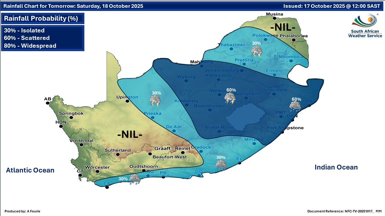
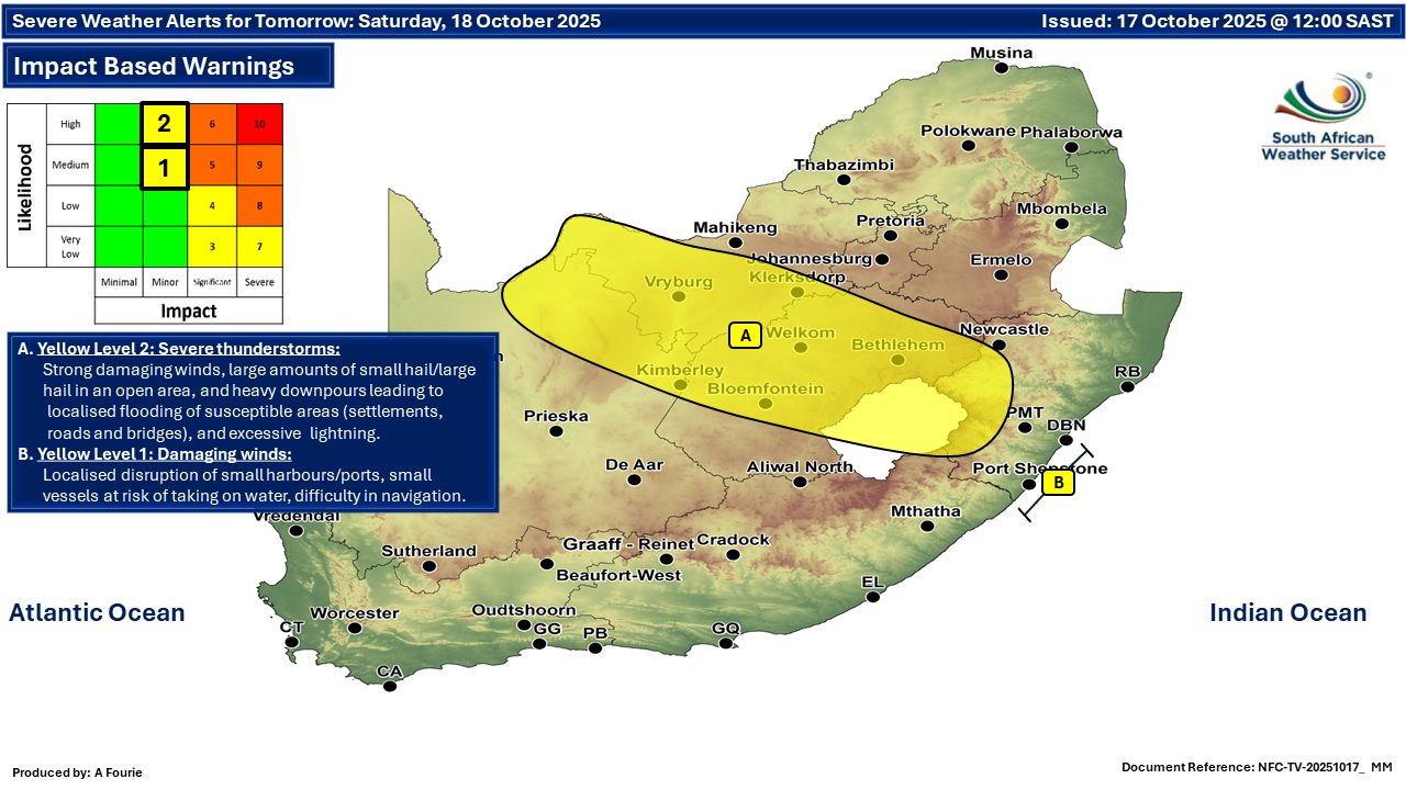
Maps for Saturday 18 October
  Maps for Sunday 19 October
|