
FRIDAY WEATHER: Cold, wet, windy with possible snow in the south-west and a thunderstorm warning for three provinces
By Staff WriterPublished: 16 April 2026 [updated 17 April]
This forecast is for: Fri 17 April 2026
The maps cover: Fri 17 Apr – Fri 17 Apr
| SHARE TO |
The latest forecast is available by clicking here.
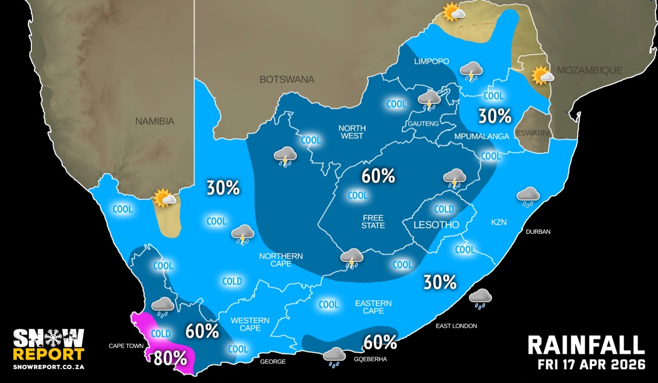
From Friday cold, wet and windy conditions will dominate the western interior, including parts of the Western Cape and Northern Cape, according to the SA Weather Service. Significant rainfall is expected over these regions, accompanied by strong winds as well as a notable drop in daytime temperatures.
SEE ALSO: Snowfall still possible for the Western Cape, Northern Cape and Lesotho from Friday.
Hot and humid weather can be expected along the north coast and adjacent interior of KwaZulu-Natal.
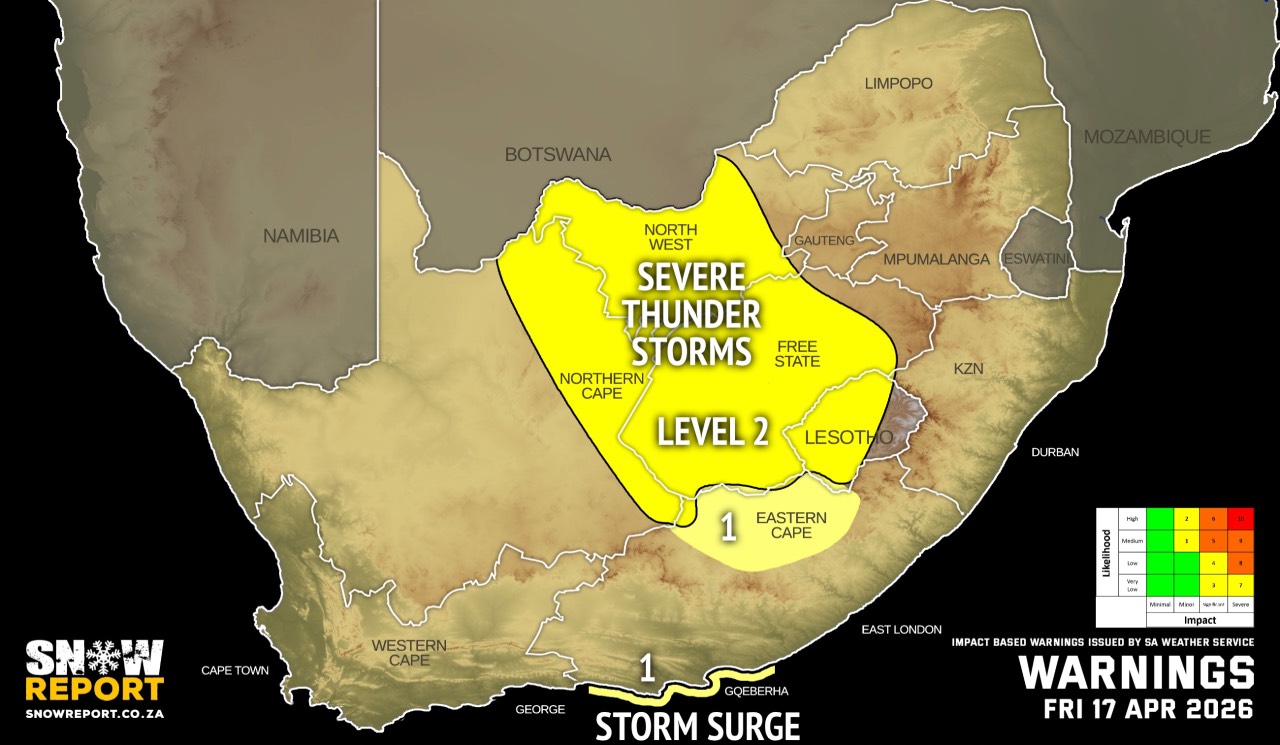
Warnings from the SA Weather Service for Friday:
A. level 2 warning for severe thunderstorms with heavy downpours resulting in localised flooding of low-lying areas, roads and bridges as well as large amounts of hail and damaging winds leading to damage to settlements and infrastructure are expected over the north-eastern parts of Northern Cape and Eastern Cape as well as the central and western parts of Free State and North West.
B. level 1 warning for severe thunderstorms over parts of the Eastern Cape.
C. level 1 warning for storm surge off the Eastern Cape coast, as per the map above.
Extremely high fire danger conditions are expected over Ubuntu, Emthanjeni and Dawid Kruiper local municipalities in the Northern Cape.
Regional forecasts from the SA Weather Service for Friday:
GAUTENG
Cloudy and cool with scattered showers and thundershowers.
MPUMALANGA
Partly cloudy and cool to warm with isolated showers and thundershowers, but scattered over the Highveld where it will be cloudy.
LIMPOPO
Partly cloudy and warm with isolated showers and thundershowers except in the Lowveld and Limpopo Valley, but scattered in the extreme south-west.
NORTH-WEST
Cloudy and cool to warm with scattered showers and thundershowers.
THE FREE STATE
Cloudy and cool to warm with scattered showers and thundershowers, but isolated in the extreme east.
THE NORTHERN CAPE
Cold in the extreme west, otherwise partly cloudy and cool to warm, with isolated to scattered showers and thundershowers, except in the north-western interior. It will be cloudy in the extreme east. The wind along the coast will be moderate to fresh southerly to south-easterly, becoming light and variable from the evening.
THE WESTERN CAPE
Partly cloudy and cool to cold with isolated showers and thundershowers but scattered to widespread over the western parts where it will be cloudy. The wind along the coast will be moderate to fresh north-westerly to westerly but strong along the south-west coast from the afternoon spreading to the south coast from the evening.
THE WESTERN HALF OF THE EASTERN CAPE
Partly cloudy and warm to hot with isolated thundershowers, but scattered along the south coast and adjacent interior. The wind along the coast will be moderate to fresh south-westerly.
THE EASTERN HALF OF THE EASTERN CAPE
Partly cloudy and warm with isolated thundershowers, but scattered in the north. The wind along the coast will be fresh to strong north-easterly, becoming moderate south-westerly in the south from evening.
KWAZULU-NATAL
Morning fog in places over interior, otherwise partly cloudy and warm with isolated showers and thundershowers. It will be hot in places in the north-east. The wind along the coast will be light northerly to north-westerly, becoming fresh to strong north-easterly from mid-morning.
Travellers forecasts from the SA Weather Service for Friday:
PRETORIA
Cloudy with scattered showers and thundershowers.
Minimum/Maximum: 15/25°C
JOHANNESBURG
Cloudy with scattered showers and thundershowers.
Minimum/Maximum: 14/25°C
VEREENIGING
Cloudy with scattered showers and thundershowers.
Minimum/Maximum: 14/24°C
MBOMBELA
Partly cloudy with isolated showers and thundershowers.
Minimum/Maximum: 17/27°C
POLOKWANE
Partly cloudy with isolated showers and thundershowers.
Minimum/Maximum: 15/26°C
MAHIKENG
Cloudy with scattered showers and thundershowers.
Minimum/Maximum: 15/24°C
VRYBURG
Cloudy with scattered showers and thundershowers.
Minimum/Maximum: 15/25°C
BLOEMFONTEIN
Cloudy with scattered showers and thundershowers.
Minimum/Maximum: 13/22°C
KIMBERLEY
Cloudy with scattered showers and thundershowers.
Minimum/Maximum: 14/24°C
UPINGTON
Partly cloudy with isolated showers and thundershowers.
Minimum/Maximum: 15/25°C
CAPE TOWN
Cloudy with widespread showers and rain.
Wind: Light to moderate north-westerly to northerly.
Minimum/Maximum: 13/16°C
GEORGE
Partly cloudy with light rain from the evening.
Wind: Light to moderate westerly to south-westerly.
Minimum/Maximum: 13/21°C
GQEBERHA
Partly cloudy with thundershowers.
Wind: Moderate to fresh south-westerly.
Minimum/Maximum: 17/23°C
EAST LONDON
Partly cloudy with isolated thundershowers.
Wind: Fresh to strong north-easterly.
Minimum/Maximum: 19/28°C
DURBAN
Partly cloudy with isolated showers and thundershowers.
Wind: fresh to strong northerly to north-easterly.
Minimum/Maximum: 22/30°C
RICHARDS BAY
Partly cloudy with isolated showers and thundershowers.
Wind: fresh to strong northerly to north-easterly.
Minimum/Maximum: 20/33°C
PIETERMARITZBURG
Morning fog patches, otherwise partly cloudy with isolated showers and thundershowers.
Minimum/Maximum: 16/28°C
This forecast is usually updated a few times per day.
| SHARE TO |
Please be sure to send photos and videos to us via whatsapp and also tell us where and when they were taken.
Follow our channels