
MONDAY WEATHER: Very cold with disruptive rain in the south-west and very strong winds across South Africa
By Staff WriterPublished: 10 May 2026
This forecast is for: Mon 11 May 2026
The maps cover: Mon 11 May – Mon 11 May
| SHARE TO |
The latest forecast is available by clicking here.
Two cold fronts are expected to affect the Western Cape from this weekend, with the first expected to make landfall on Sunday while a second and more powerful frontal system will impact the province from Monday according to the SA Weather Service.
See our SNOW FORECAST for the disruptive snowfall from Sunday.
Warnings from the SA Weather Service from Monday:
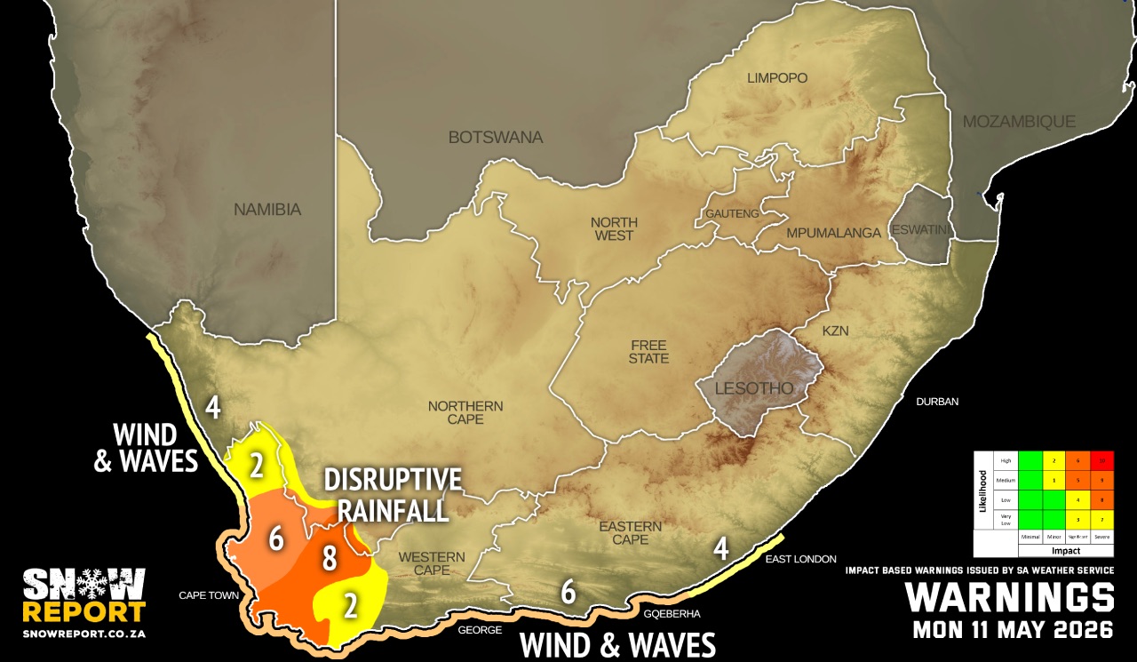
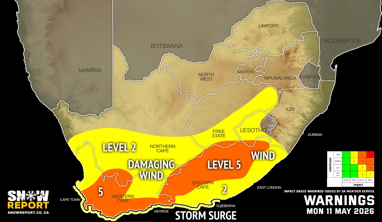
A. level 8 warning for disruptive rainfall leading to flooding of roads, bridges and formal and informal settlements, mudslides and danger to life due to fast flowing rivers over the mountainous regions of the Drakenstein, Stellenbosch, the western parts of the Theewaterskloof, City of Cape Town, Breede Valley and Witzenberg local municipalities of the Western Cape until Tuesday.
B. level 6 warning for disruptive rainfall leading to flooding of roads, low-lying bridges, and formal as well as informal settlements over the southern West Coast and western parts of the Overberg Districts of the Western Cape until Tuesday.
C. level 6 warning for damaging winds and waves leading to danger to navigation at sea and damage to coastal infrastructure along the coast between Lambert's Bay and Cannon Rocks until Tuesday.
D. level 5 warning for damaging interior winds leading to damage of formal and informal settlements, power interruptions and closure of some routes due to falling trees over the central and southern parts of the Western Cape and northern and central part of the Eastern Cape, but expected in the Western Cape until Tuesday.
E. level 4 warning for damaging winds and waves leading to danger to navigation at sea along the coast between Alexander Bay to Lambert's Bay and Cannon Rocks to East London until Tuesday.
F. level 2 warning for disruptive rainfall leading to localised flooding of low-lying bridges, and formal as well as informal settlements over the northern parts of the West Coast, eastern parts of the Cape Winelands and Overberg Districts of the Western Cape until Tuesday.
G. level 2 warning for damaging winds leading to localised damage of informal settlements, falling trees and localised problems for high-sided vehicles on prone routes in places in the Western Cape and Eastern Cape, the Free State as well as the central and southern part of the Northern Cape until Tuesday.
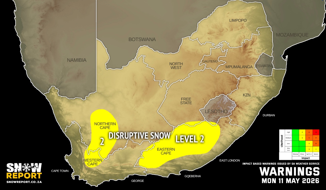
H. level 2 warning for disruptive snowfall leading to loss of vulnerable livestock, disruption of traffic due to icy roads and possible closure of mountain passes over the northern part of the Eastern Cape until Monday.
I. level 2 warning for storm surge leading to localised flooding of low lying coastal areas between Saldanha Bay and Algoa Bay until Tuesday.
Regional forecasts from the SA Weather Service for Monday:
GAUTENG
Fine and cool to cold.
MPUMALANGA
Fine and cool to warm. It will be cold in places in the east as well as in the south.
LIMPOPO
Fine and cool to warm.
NORTH-WEST
Fine, windy and cool to warm.
THE FREE STATE
Partly cloudy to cloudy in the south where isolated showers are expected, otherwise fine, windy and cold.
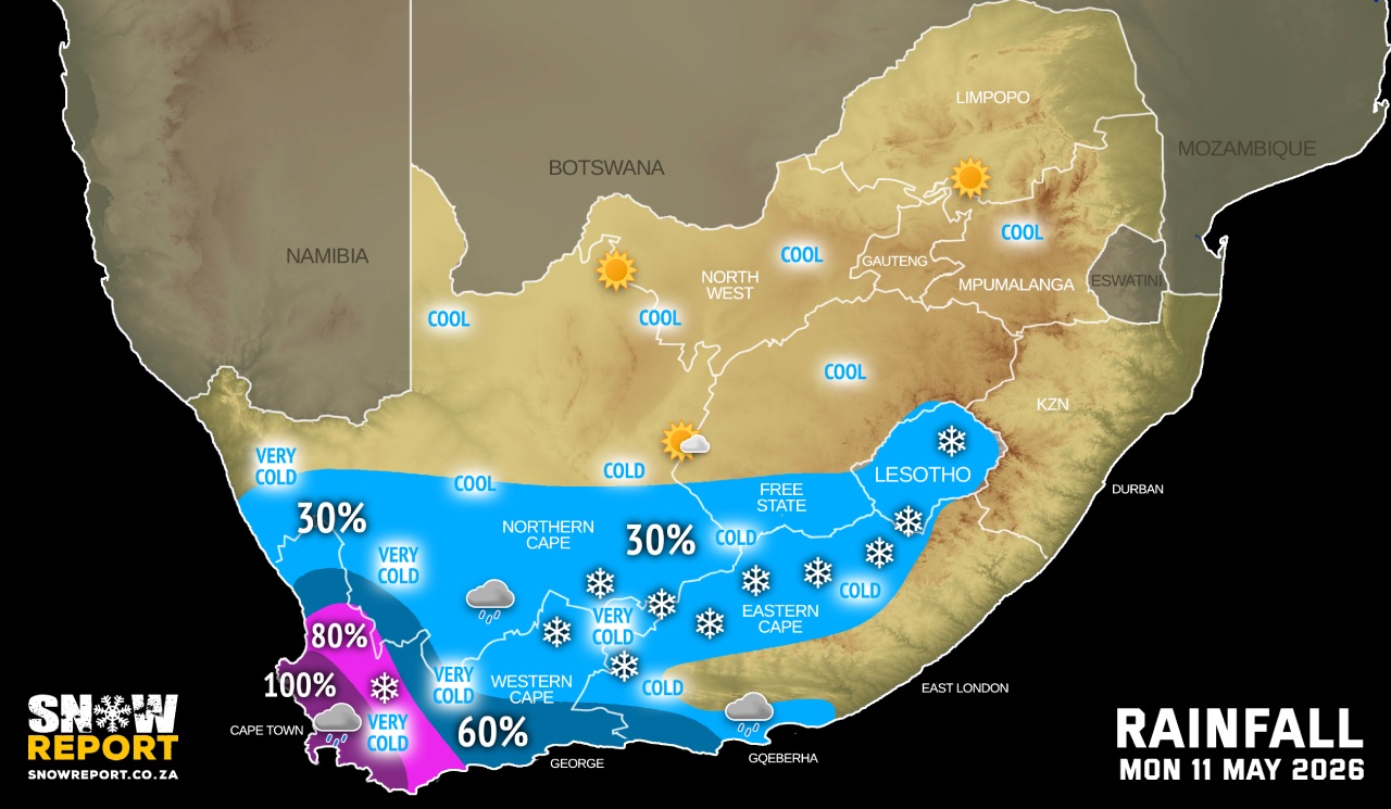
THE NORTHERN CAPE
Fine to partly cloudy in the north, otherwise cloudy, windy and very cold to cold with isolated showers and thundershowers, except the northern part. Snowfall expected in the south. The wind along the coast will be fresh to strong west to north-westerly.
THE WESTERN CAPE
Cloudy, windy and cold to cool, with widespread to scattered rain and showers, but isolated in the north-east. The wind along the coast will be Gale to strong gale westerly to north-westerly.
THE WESTERN HALF OF THE EASTERN CAPE
Snowfall expected in the north, otherwise cloudy, wind and cold with isolated showers and rain along the coast and adjacent interior, but scattered west of Port Elizabeth. The wind along the coast will be strong to gale force north-westerly.
THE EASTERN HALF OF THE EASTERN CAPE
Snowfall expected in the north, otherwise cloudy to partly cloudy and cold, but cool in places along the coast. The wind along the coast will be strong north-westerly.
KWAZULU-NATAL
Fine and cool but warm in the east. The wind along the coast will be moderate to fresh westerly to north-westerly north of Durban, otherwise fresh to strong westerly to south-westerly. It will become moderate to fresh north-easterly south of Richards Bay in the afternoon spreading northwards towards evening but easterly to south-easterly north of Mtunzini at times in the afternoon.
Travellers forecasts from the SA Weather Service for Monday:
PRETORIA
Fine.
Minimum/Maximum: 07/19°C
JOHANNESBURG
Fine.
Minimum/Maximum: 04/15°C
VEREENIGING
Fine.
Minimum/Maximum: 05/15°C
MBOMBELA
Fine.
Minimum/Maximum: 10/27°C
POLOKWANE
Fine.
Minimum/Maximum: 12/24°C
MAHIKENG
Fine.
Minimum/Maximum: 05/17°C
VRYBURG
Fine.
Minimum/Maximum: 02/17°C
BLOEMFONTEIN
Fine to partly cloudy
Minimum/Maximum: 02/13°C
KIMBERLEY
Fine.
Minimum/Maximum: 02/17°C
UPINGTON
Partly cloudy.
Minimum/Maximum: 05/17°C
CAPE TOWN
Cloudy and windy with widespread rain and showers.
Wind: Strong to gale north-westerly.
Minimum/Maximum: 11/17°C
GEORGE
Cloudy with scattered rain showers from the mid-morning.
Wind: Fresh to strong north-westerly.
Minimum/Maximum: 10/18°C
GQEBERHA
Fine and windy, becoming cloudy with isolated showers and rain from late morning.
Wind: Strong to near gale force north-westerly.
Minimum/Maximum: 10/18°C
EAST LONDON
Fine and windy, becoming partly cloudy in the afternoon.
Wind: Strong north-westerly.
Minimum/Maximum: 15/20°C
DURBAN
Fine.
Wind: Moderate to fresh westerly to south-westerly, becoming moderate to fresh north-easterly in the afternoon.
Minimum/Maximum: 18/25°C
RICHARDS BAY
Fine.
Wind: Moderate to fresh westerly to north-westerly in the morning, otherwise light to moderate south-easterly to easterly. It will become moderate to fresh north easterly in the late afternoon.
Minimum/Maximum: 18/25°C
PIETERMARITZBURG
Fine.
Minimum/Maximum: 09/22°C
This forecast is usually updated a few times per day.
| SHARE TO |
Please be sure to send photos and videos to us via whatsapp and also tell us where and when they were taken.
Follow our channels