
![Snow forecast map for 7 May 2026 [updated 9 May]](/img/SR-Map-9-May-2026-F2-cropped.jpg)
Disruptive snowfall from Sunday in the Western Cape, Northern Cape and Eastern CapeBy Staff WriterPublished: 7 May 2026 [updated 9 May] This forecast covers: Sun 10 May – Mon 11 May
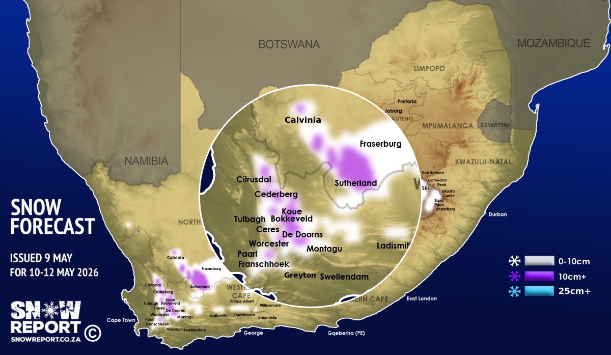
More snowfall is possible from Sunday through to Monday for the Western Cape, Northern Cape, Eastern Cape, the Free State and Lesotho with low-level snow currently indicated for some areas. More than 30cm of snow is also indicated at higher elevations for some of areas marked in purple on the map, including the Hex River mountains between Ceres and De Doorns in the Western Cape. Heavier snow is also indicated for the Northern Cape around Sutherland, as marked in purple on the map. Also see below more map with a zoomed in regional section. Heavier snow is also indicated for the Eastern Cape at higher elevations around Barkly East, Rhodes and Wartrail, as marked in purple on the map. Snow is indicated for the high-ground or mountains around places like Paarl, Stellenbosch, Franschhoek, Worcester, Rawsonville, Wolseley, Tulbagh, Ceres, De Doorns, the Koue Bokkeveld, the Cederberg, Robertson, Montagu, Greyton, Swellendam, Sutherland, Calvinia, Fraserburg, Loxton, Carnavon, Ladismith, the Swartberg range, Uniondale, Middelburg, Richmond, Noupoort, De Aar, Nieu-Bethesda, Molteno, Dordrecht, Barkly East, Khowa (Elliot), Lady Grey and Rhodes. With the freezing level dropping as low as 1500m on Sunday, snow may result in some mountain passes being closed from early on Sunday. Note that Matroosberg Reserve they have announced that they will be CLOSED during this time. The low-level snow in the Koue Bokkeveld and the moutains around Ceres is only expected from the middle of the day or later so be careful of getting stuck in snow late in the day when the weather takes a turn for the worst. If you do venture out for the snow, please respect fences and gates, and don't go onto private property. The SA Weather Service have issued a level 2 warning for disruptive snowfall leading to loss of vulnerable livestock, disruption of traffic due to icy roads and possible closure of mountain passes over parts of the Western Cape, Northern Cape and Eastern Cape. SEE ALSO: Disruptive rainfall / snowfall, damaging winds & waves with flooding possible on Sunday – many warnings issued. Those planning to hike up higher into snow in places like Mont Rochelle Nature Reserve should note that gale-force winds may come into play that dramatically reduce the temperature and significantly increase the danger level. This is one of those times when these activities are best left to those with experience in extreme weather. Alternatively it would be safer to wait until after the weather clears, since the snow may stick around on the peaks into next week (Monday is definitely NOT a good day for this due to the extreme winds that will make conditions dangerous on the moutains). Some of the higher ground in Lesotho is indicated to receive snowfall again. ALSO READ: Be prepared for safe winter travel and snow chasing trips. SEE ALSO: Widespread snow fell in South Africa and Lesotho this week. Click here for photos. The map indicates where we are seeing the possibility of snow, but it may not fall in all of the areas shown on the map. As with any forecast of any kind (temperature, clouds, rain, wind), what eventually happens may or may not be similar to the forecast. Snow indicated may reduce or vanish completely in some areas, or the dates and times may change. Follow our channels
Standard users are welcome to use the standard sharing buttons on this page to share our content. It is NOT acceptable to download or screen grab for reposting. Other media and channels need to send us a request in order to embed or use of our forecasts, maps, as well as images and video from our users that we post (before doing so).
|