
Widespread snow expected across South Africa and Lesotho - and maybe Table Mountain8 June 2020By Staff Writer
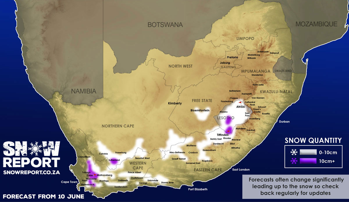
Widespread snow is expected across South Africa and Lesotho from Wednesday 10 June, with the chance of disruptive snowfalls in some areas. Light snow may also fall on Table Mountain in Cape Town on Wednesday night. A significant front that will move into the Western Cape from the early hours of Wednesday morning is expected to bring more than 50mm of rain and this could see snowfalls of up to 25cm on the high-peaks of the Cape ranges. Snow is also expected to fall at lower elevations as the freezing level drops down to 1400m in places. Snow is currently expected across the Western Cape, Eastern Cape, Northern Cape, Lesotho, and possibly the Free State as indicated on the map. Temperatures are expected to drop well below zero in some areas, with higher elevations reaching below -10 degrees Celsius in parts of the country. The snow is expected to begin falling in the early hours of Wednesday morning and will continue through Thursday with the possibility of some snow still falling on Friday morning. In the Western Cape most of the high-peaks around Somerset West, Stellenbosch, Franschhoek, Paarl, Wellington, Tulbagh, Worcester, Ceres, De Doorns, the Koue Bokkeveld and the Cederberg are expected to get snow. As the front moves east the peaks around Robertson, Montagu and Swellendam should get some snow. The Swartberg range north of Ladismith, Oudtshoorn and De Rust should also be in the zone. The mountains around Beaufort West are also expected to get a dusting. Snow is also expected on the high peaks in the south of the country, including on the Outeniqua range outside George and the peaks around Uniondale and Storms River. The southern parts of the Northern Cape around Sutherland, Calvinia, Fraserberg are also expected to get snow. Further inland in the Eastern Cape, snow is expected on the high ground around Graaff-Reinet, Nieu-Bethesda, Hogsback, Queenstown, Dordrecht, Barkly East and Rhodes. There is a small chance that the high ground surrounding Bloemfontein in the Free State may also get some very light snow, as per the map. There is also potential for snow on the Malutis near Clarens, but at this point Clarens itself is not expected to receive any. Snow is also likely across much of Lesotho, with heavier falls in west and south-west of the country. The low-level snow combined with the sub-zero temperatures in places means that some mountain passes could be closed due to disruptive snowfalls at some point. We have a FREE channel on Telegram Messenger, so please download it if you want to be the first to know when snow is forecast or photos are posted. Click to join our Telegram Channel We would like to remind snow lovers that those traveling to see snow should do so safely, while noting travel regulations. Please be sure to send photos and videos to us via whatsapp to 081 251 8029. Please note on snow days we do not have the capacity to answer questions so please watch our facebook page to see what is happening. Don't miss the opportunity to stay relevant during the lockdown by advertising your brand or service with SA's biggest winter-focused media channel, even if you're not trading right now. * Please note SnowReportSA's updated terms & conditions for the use of our forecasts, maps, images and video by other media and channels. Sharing, where permitted by us, must be done using standard sharing buttons. Podcast audio may not be used for broadcast without our permission. See the media guidelines link below for details.
|