
 More weather maps below the forecast
More severe weather warnings for Monday and more snow6 July 2024 [updated 7 July]By Staff Writer
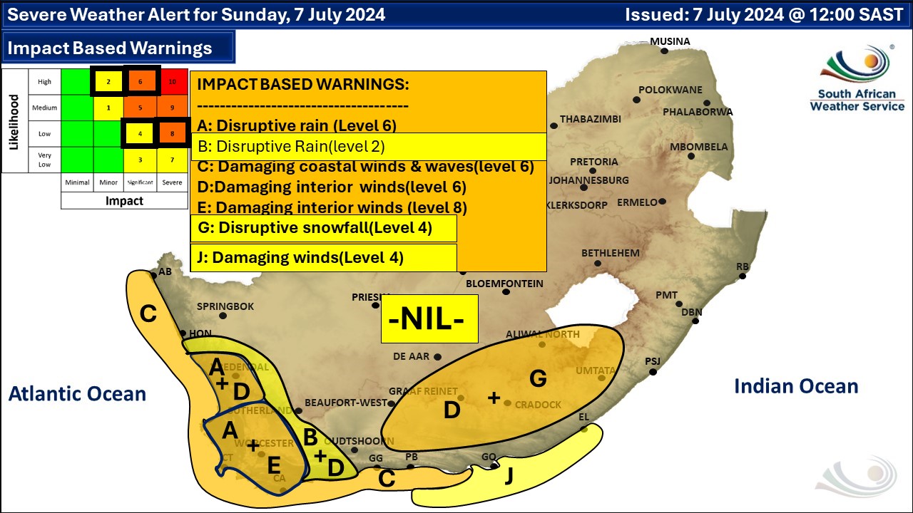
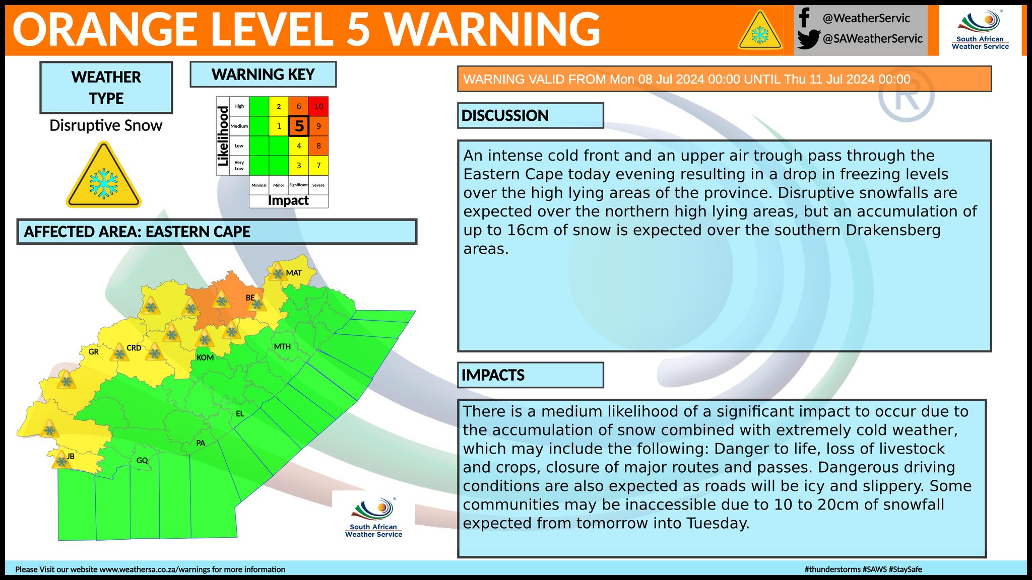
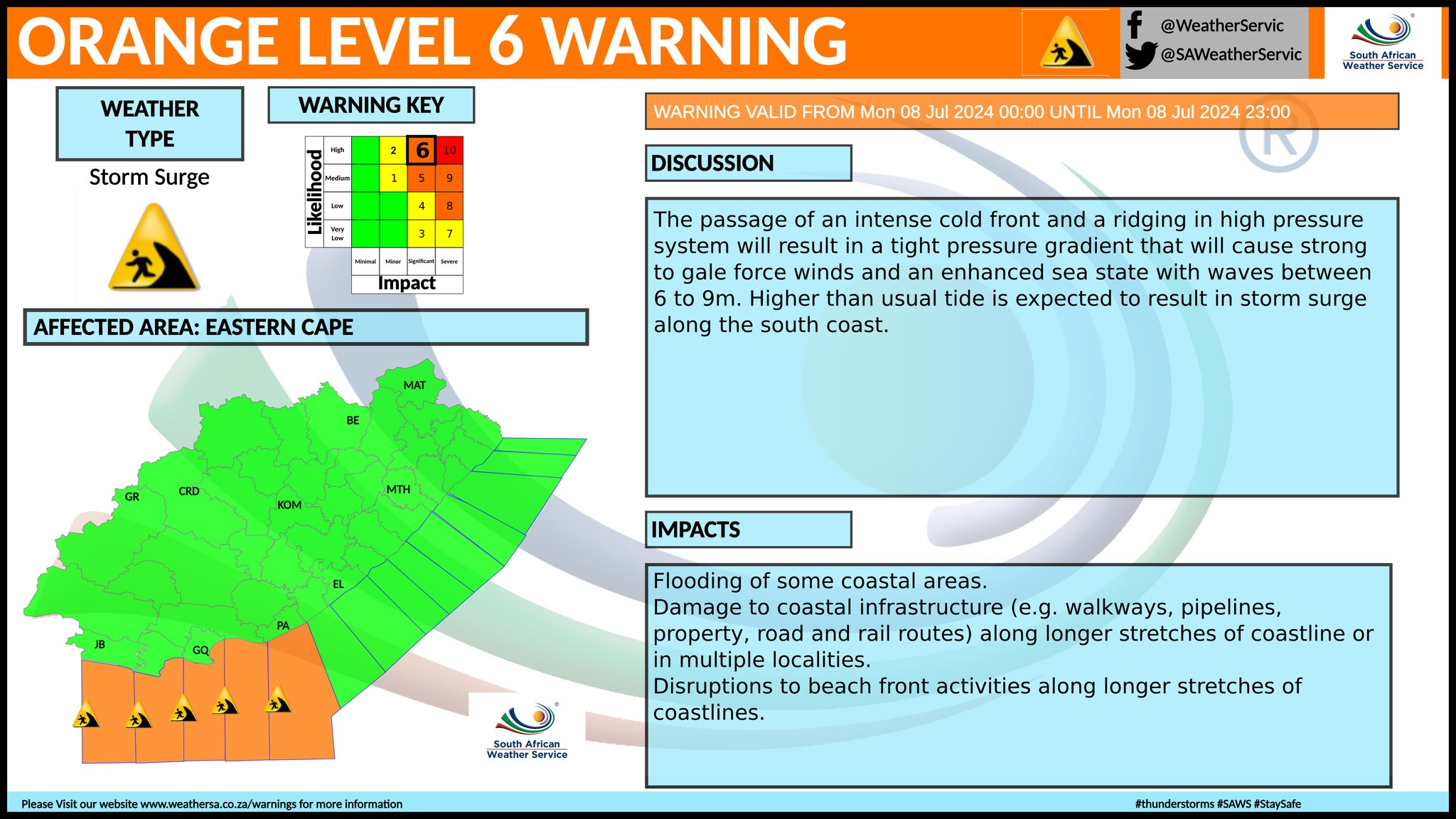
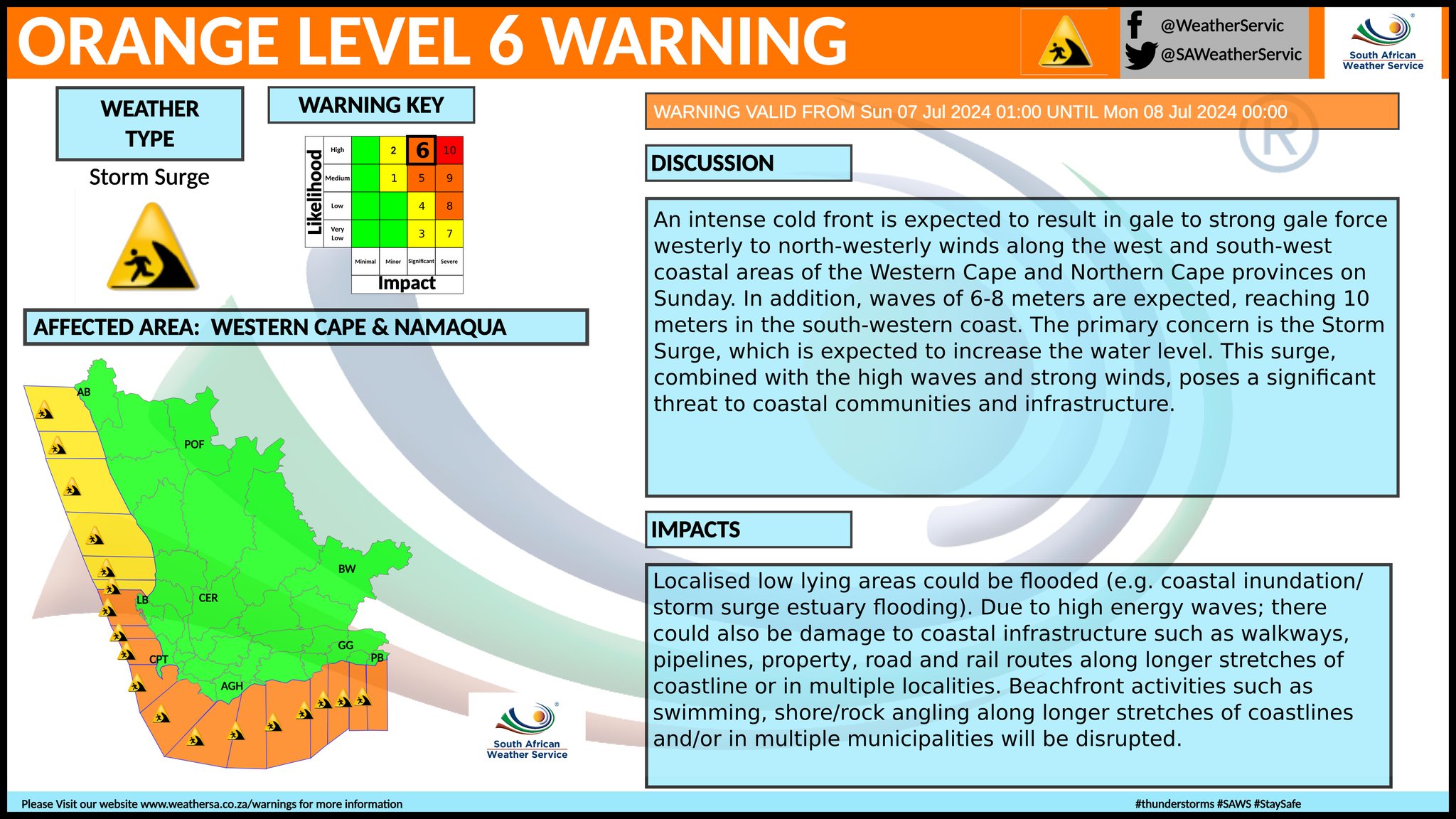
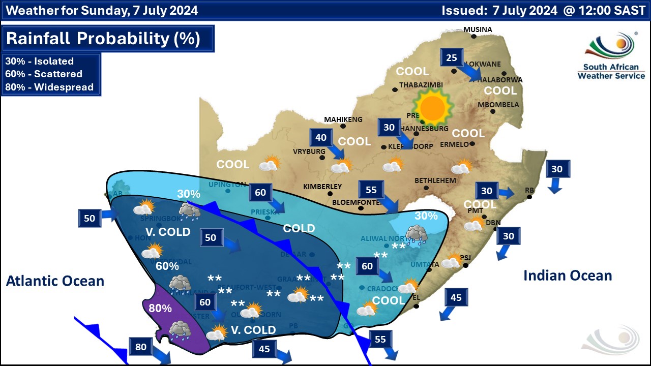
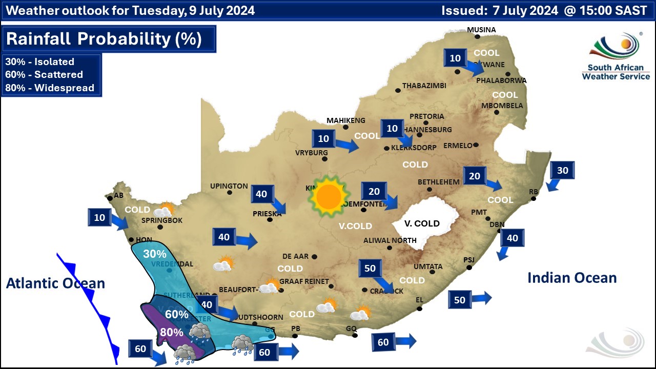
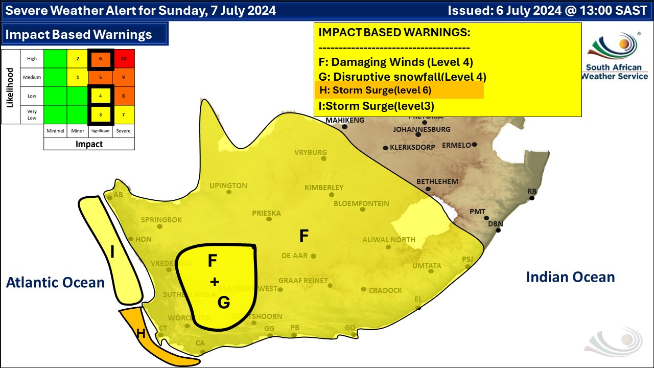
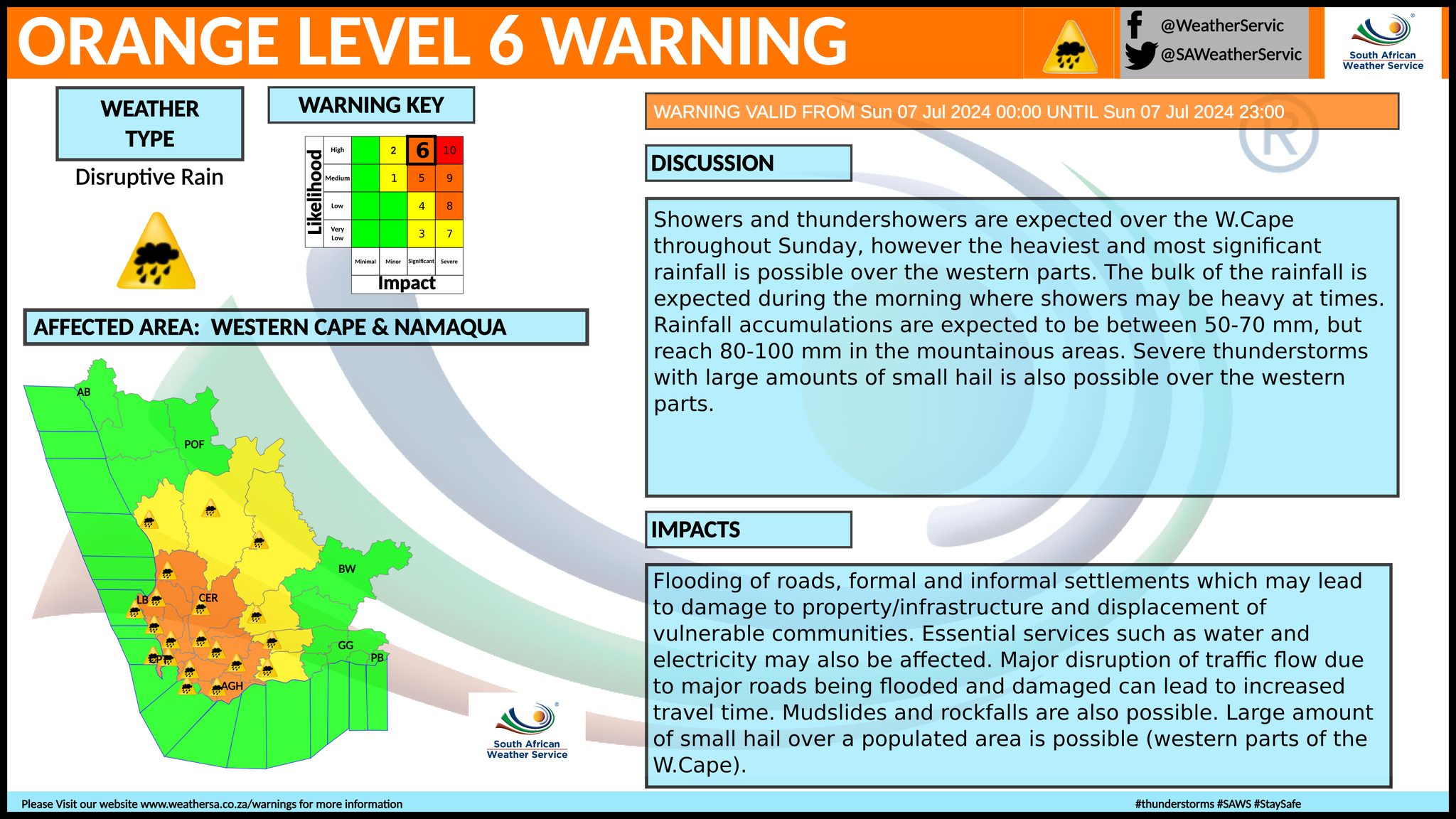
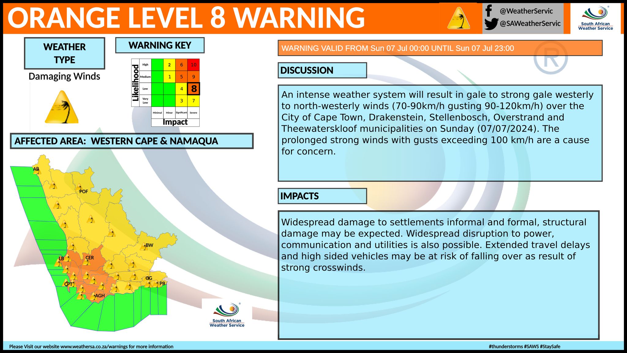
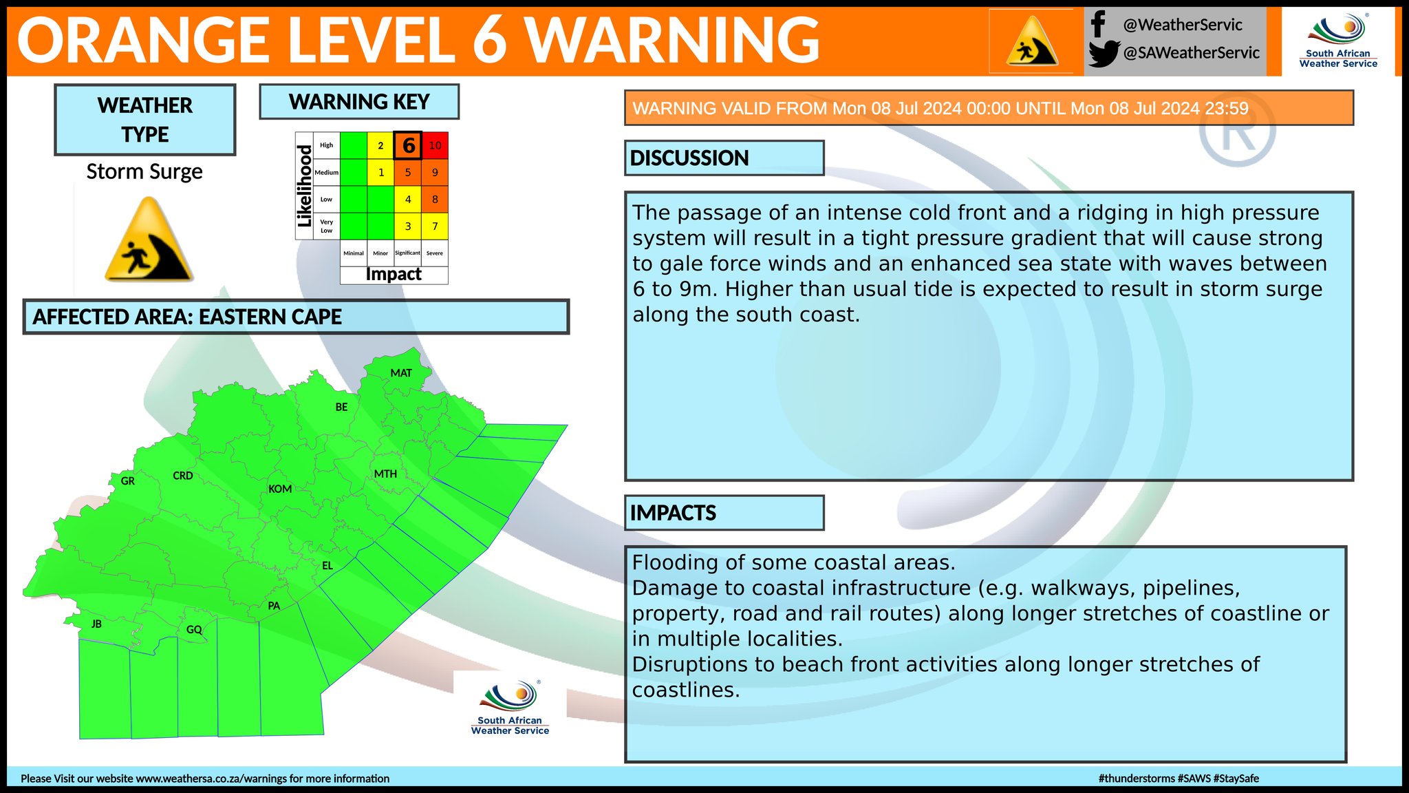
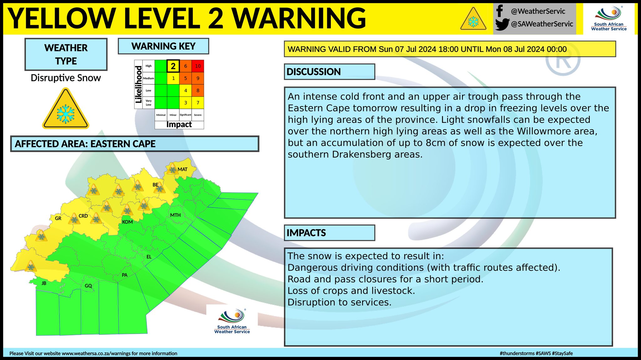
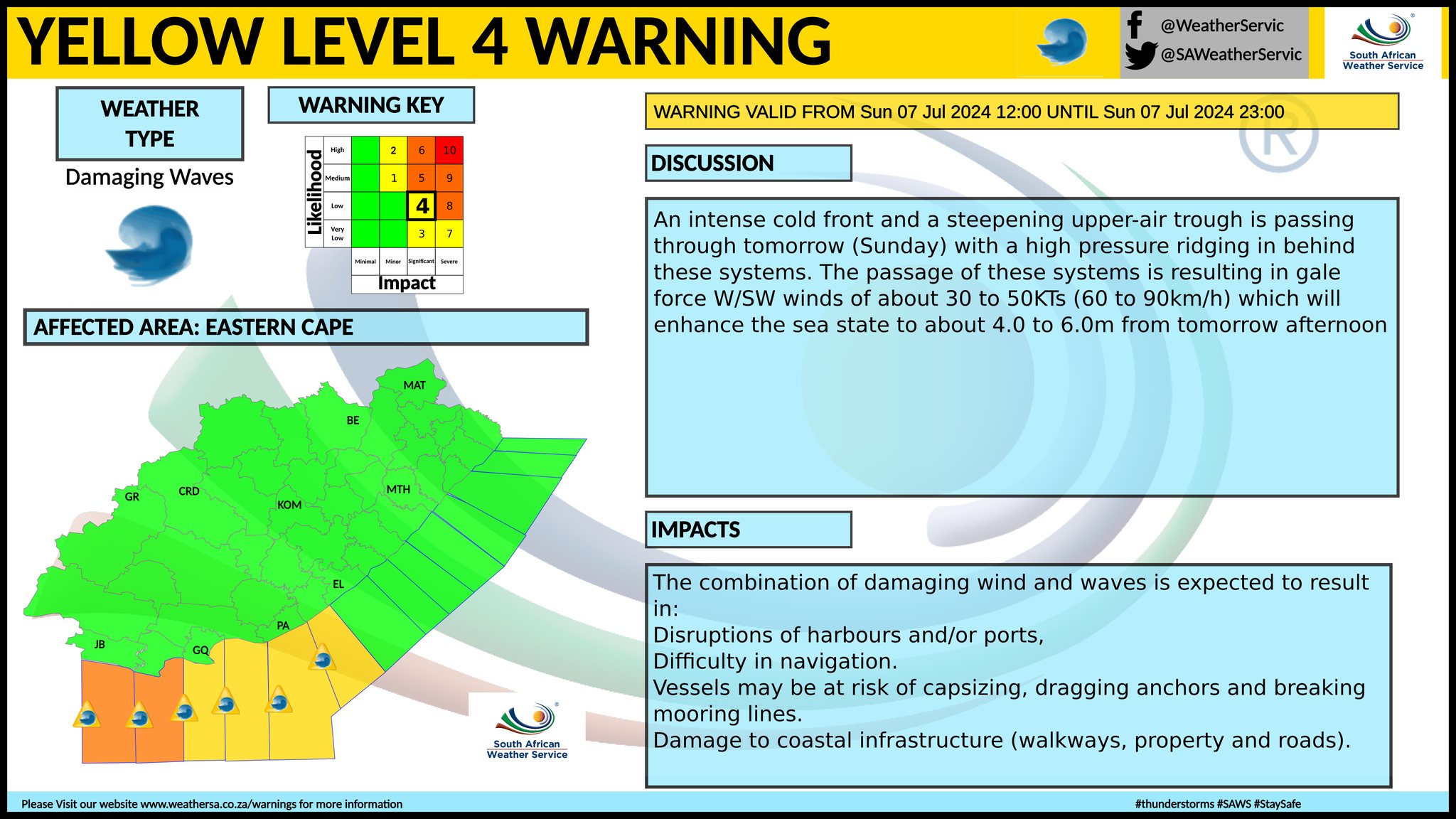
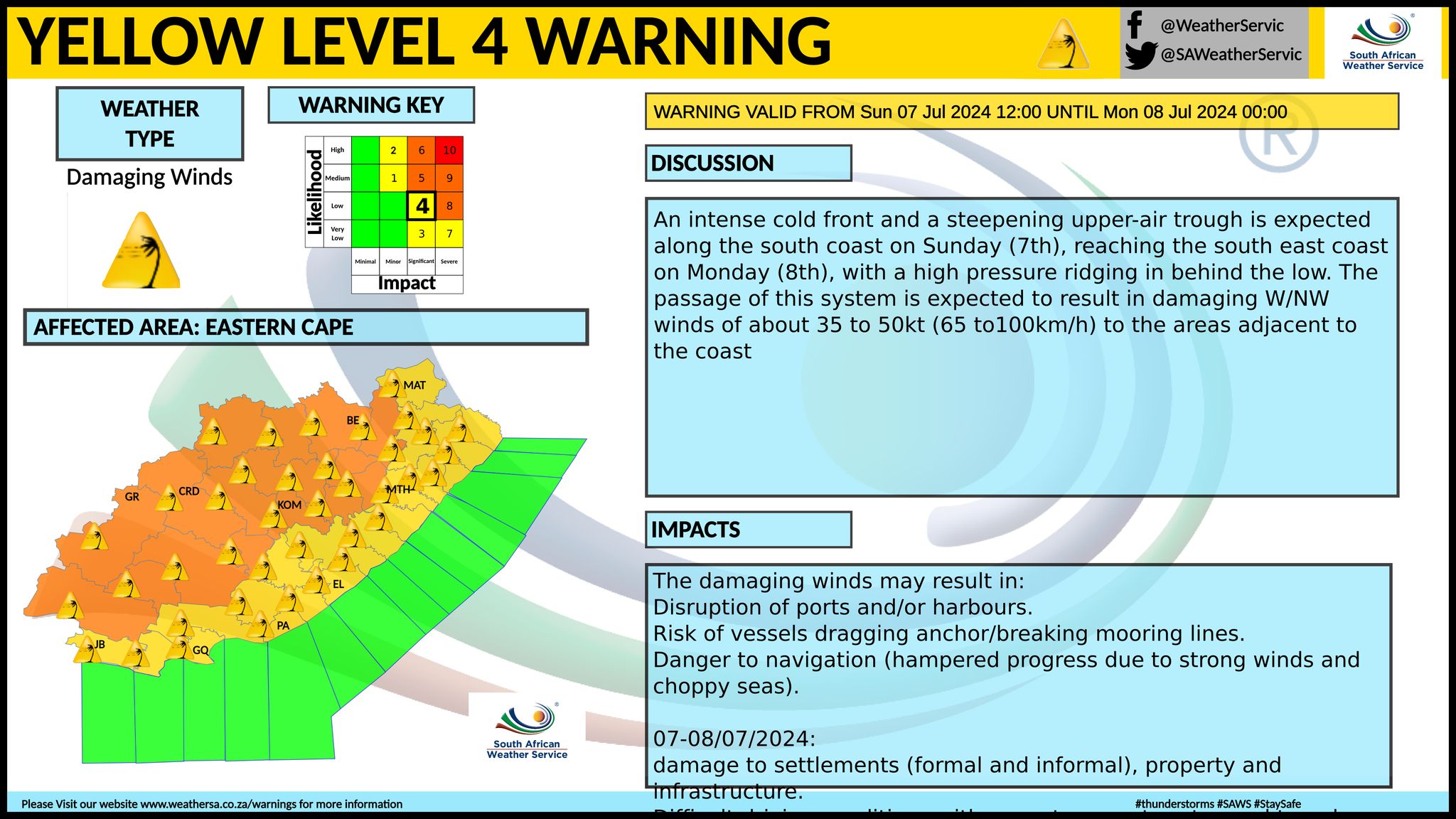
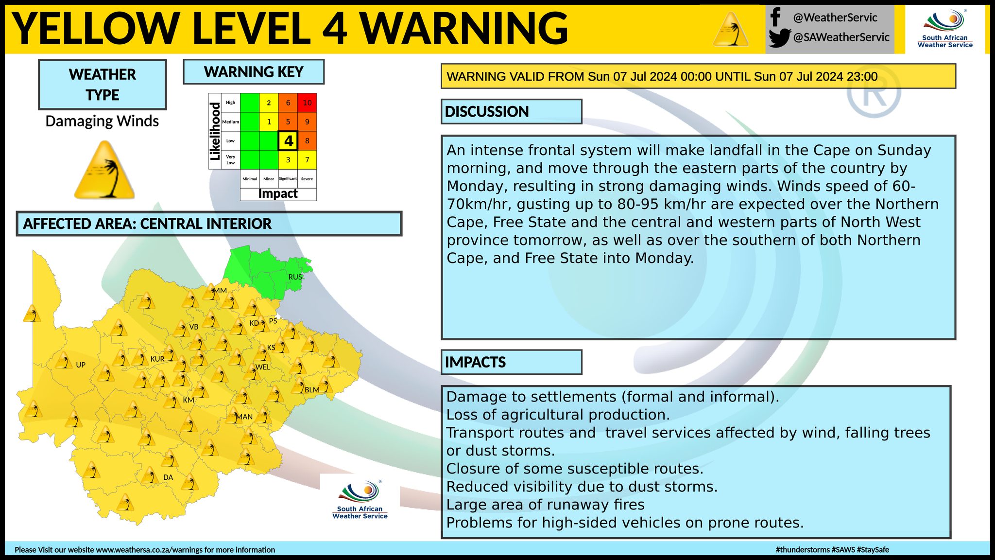
This is no audio podcast version of this forecast today. A newer weather forecast can be found here. The South African Weather Service (SAWS) have advised that very wet, cold, and windy conditions, with light snow can be expected over the Northern Cape, North-West, Free State, Eastern Cape interior and the Western Cape on Monday. The public and small stock farmers are advised that intermittent heavy downpours, snowfalls, very cold conditions, strong coastal and interior winds and very rough seas can be expected. We have also updated a forecast for heavy low-level disruptive snowfall for Sunday and Monday here. Extremely high fire danger conditions are expected in places over northern KwaZulu Natal on Monday. Weather warnings in effect for Monday from SAWS. See the various maps below that these warnings apply to. A. yellow level 2 warning for disruptive snow leading to loss of livestock and traffic disruption due to icy roads is expected over the interior of Eastern Cape, central and north-western parts of the Western Cape, southern parts of the Northern Cape and Free State. B. orange level 6 warning for damaging coastal winds and waves leading to damage of coastal infrastructure along longer stretches of coastline is expected between Alexander Bay and Durban. C. orange level 6 warning for storm surge leading to localised low-lying areas flooded and disruptions to beach front activities is expected along longer stretches of coastlines between Cape Columbine and Cape Agulhas, spreading to Port Alfred on Monday morning. D. yellow level 3 warning for storm surge leading to localised low-lying areas flooded is expected between Cape Columbine and Alexander Bay. E. orange level 6 warning for damaging winds leading to damage to settlements, properties and infrastructure as well as danger to life is expected over central interior of Eastern Cape. F. yellow level 4 warning for damaging winds resulting in damage to property, difficult driving conditions and communication and power interruptions is expected over the coastline and adjacent interior of the Eastern Cape and over the western parts of KwaZulu Natal. ALSO READ: Be prepared for safe winter travel and snow chasing trips. Regional forecasts from SAWS for Monday: GAUTENG Fine, cool and windy. The expected UVB sunburn index: High MPUMALANGA Fine and cold to cool. LIMPOPO Fine and cold to cool. THE NORTH-WEST PROVINCE Partly cloudy in the west, otherwise fine and cold to very cold. THE FREE STATE Cloudy to partly cloudy and very cold, with isolated showers and thundershowers, except in the north. Snowfall and windy conditions is expected over the southern parts and along the Lesotho border. THE NORTHERN CAPE Cloudy and cold to very cold with isolated to scattered showers and thundershowers. Possible snowfalls are likely over the southern high-ground. The wind along the coast will be strong to gale westerly becoming south-westerly in the afternoon. THE WESTERN CAPE Cloudy and cold to very cold with widespread showers and rain over the south-western parts but isolated to scattered in the central and eastern parts. Snowfalls are likely over the western high-ground and eastern mountain peaks. The wind along the coast will be fresh to strong south-westerly to westerly along the western and south-western coast becoming north-westerly from the evening, otherwise strong to gale south-westerly to westerly. The expected UVB sunburn index: Low THE WESTERN HALF OF THE EASTERN CAPE Partly cloudy and cold in places in the south-east, otherwise cloudy, windy and very cold with isolated showers and rain, but scattered showers and thundershowers in places along the coast west of Port Alfred. Snowfall is expected over the high lying areas (including south-western mountains). The wind along the coast will be fresh to strong north-westerly in places in the morning, otherwise strong to gale force westerly. THE EASTERN HALF OF THE EASTERN CAPE Fine and cold south-east of the escarpment, otherwise cloudy, windy and very cold with isolated showers and rain. Snowfall is expected over the high lying areas. The wind along the coast will be fresh to strong westerly, reaching gale force in places. KWAZULU-NATAL Partly cloudy in places in the west, otherwise fine and cool but cold in the west. The wind along the coast will be moderate to fresh westerly to south-westerly, becoming strong to near-gale in the south towards afternoon. The expected UVB sunburn index: High Travellers forecast from SAWS for Monday: PRETORIA Fine and windy. Minimum/Maximum: -1/14°C The expected UVB Sunburn Index: High JOHANNESBURG Fine and windy. Minimum/Maximum: -2/10°C VEREENIGING Fine and windy. Minimum/Maximum: -4/10°C MBOMBELA Fine. Minimum/Maximum: 8/22°C POLOKWANE Fine Minimum/Maximum: 5/18°C MAHIKENG Fine. Minimum/Maximum: -2/11°C VRYBURG Partly cloudy Minimum/Maximum: -5/10°C BLOEMFONTEIN Cloudy and windy, with isolated showers and thundershowers. Minimum/Maximum: -6/7°C KIMBERLEY Cloudy, with isolated showers and thundershowers. Minimum/Maximum: -4/8°C UPINGTON Cloudy, with isolated showers and thundershowers. Minimum/Maximum: -1/10°C CAPE TOWN Mostly cloudy and windy with widespread showers and rain. Wind: Moderate to fresh south-westerly, becoming north-westerly moderate to fresh from the afternoon. Minimum/Maximum: 9/12°C The expected UVB Sunburn Index: Low GEORGE Cloudy with isolated showers and rain from the afternoon Wind: Strong to gale south-westerly to westerly. Minimum/Maximum: 6/11°C GQEBERHA Partly cloudy, but cloudy with scattered showers and rain at times. Ice pellets may be possible. Wind: Fresh to strong westerly, becoming gale force from mid-morning. Minimum/Maximum: 8/13°C EAST LONDON Fine, but partly cloudy in the afternoon. Wind: Fresh to strong westerly, possibly reaching gale force from late afternoon. Minimum/Maximum: 11/16°C DURBAN Fine. Wind: Moderate to fresh westerly to south westerly, becoming strong to near-gale in the afternoon. Minimum/Maximum: 11/21°C The expected UVB Sunburn Index: High RICHARDS BAY Fine. Wind: Moderate to fresh north-westerly, becoming fresh westerly to south-westerly. Minimum/Maximum: 13/23°C PIETERMARITZBURG Fine, becoming partly cloudy at times. Minimum/Maximum: 0/17°C See the South African Weather Service maps below. This forecast changes regularly and updates will be issued periodically. Please be sure to send photos and videos to us via whatsapp and also tell us where and when they were taken. See below for a link to our whatsapp channel but since the link does not work in the instagram app you will need to send us a whatsapp message and we'll send you a link. Follow our channels
Standard users are welcome to use the standard sharing buttons on this page to share our content. It is NOT acceptable to download or screen grab for reposting. Other media and channels need to send us a request in order to embed or use of our forecasts, maps, as well as images and video from our users that we post (before doing so).
Issued on Sunday
           Issued on Saturday
          |