
       Swipe left or right for more maps, and see below for others
Seven weather warnings from Monday – disruptive and dangerous snowfall, rain and thunderstormsBy Staff WriterPublished: 8 June 2025 [updated 9 June] This forecast is for: Mon 09 June 2025 The maps cover: Mon 09 Jun – Wed 11 Jun
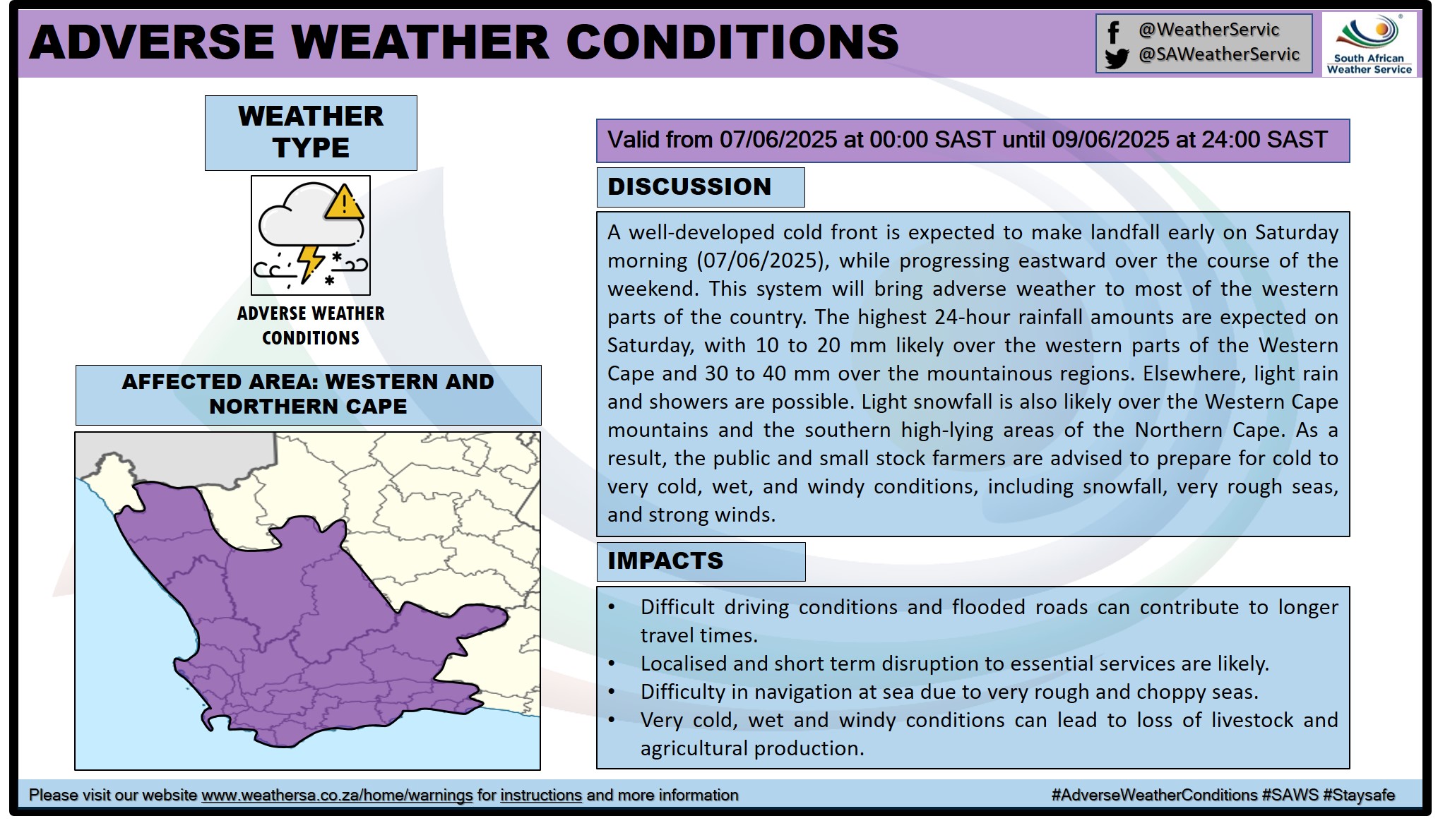
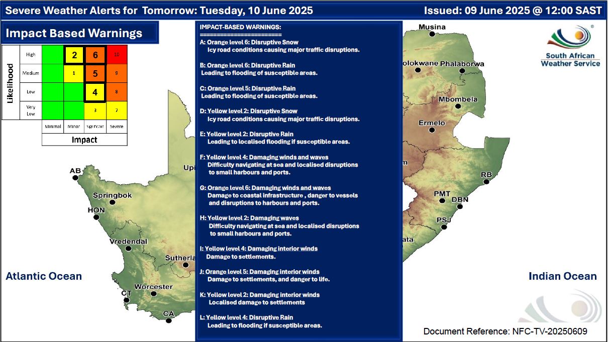
A newer forecast is available by clicking here. A cut-off low is passing over the south-central parts and expected to result in snowfall over the high-lying areas, exiting the country through the south-east on Tuesday, according to the SA Weather Service (SAWS). Snowfall is expected over high-lying areas and mountain peaks leading to icy road conditions over the Beaufort West municipality of the Western Cape and southern High-ground of the Northern Cape Sunday evening, spreading to the southern high-ground of the Free State (reaching the extreme southern and eastern parts), northern high-ground of the Eastern Cape, as well as the south-western and western high-ground of KwaZulu-Natal from Monday until Wednesday. This will be accompanied by very cold, wet and windy conditions over the interior of the Western Cape and Namakwa District of the Northern Cape Sunday, spreading eastwards to affect the southern parts of the Free State, the interior of the Eastern Cape and the western interior of KwaZulu-Natal on Monday through Wednesday. ALSO READ: Widespread snowfall possible for South Africa and Lesotho – low-level and disruptive for some regions. Warnings from the SA Weather for Monday: A. level 6 warning for disruptive snow resulting in danger to life, pass closures and communities cut-off over Joe Gqabi district municipality as well as Enoch Mgijima (Molteno) and Matatiele local municipalities in the Eastern Cape. B. level 6 warning for disruptive rain leading to flooding of settlements / property, roads, danger to life with some communities temporarily cut off is, expected in places over Amatholo and OR Tambo district municipalities as well as Buffalo CIty Metro in the eastern cape. C. level 5 warning for disruptive rain leading to danger to life, flooding and displacements of settlements as well as mudslides over Alfred Nzo district municipality, Nelson Mandel Bay Metro of the Eastern Cape, including the following local municipalities: Makana, Ndlambe, Sundays River, Valley, Kouga and Koukamma. D. level 2 warning for disruptive snow leading to loss of livestock, minor passes closed and traffic disruptions due to snow and icy roads over the Chris Hani district municipality of the Eastern Cape, as well as the following local municipalities: Dr Beyers Naude (Graaff-Reinet), Raymond Mhlaba, Amahlati and Umzimvubu. E. level 2 warning for disruptive rain leading to localised flooding of settlements, and roads in places over Joe Gqabi and Chris Hani district municipalities of the Eastern Cape, as well as the following local municipalities: Blue Crane Route and Dr Beyers Naude. F. level 2 warning for damaging waves leading to difficulty in navigation at sea, are expected between Saldanha Bay and Plettenberg Bay in the morning. G. level 2 warning for severe thunderstorms leading to heavy downpours resulting to localised flooding, large amount of small hail, and damaging winds, are expected over the southern and eastern parts of KwaZulu-Natal. Warnings from the SA Weather for Tuesday: There are 12 weather warnings in effect for Tuesday and they can be found on the maps below. Regional forecasts from SAWS for Monday: 1. GAUTENG Cool in places in the north, otherwise partly cloudy and cold, becoming cloudy with isolated showers and rain. The expected UVB sunburn index: Low 2. MPUMALANGA Partly cloudy and cool to cold becoming cloudy on the highveld towards the afternoon with isolated showers and rain but scattered in the extreme south where thunderstorms are likely. It will be warm in the Lowveld. 3. LIMPOPO Fine becoming partly cloudy and cool to warm but cloudy in the south-west with isolated showers and rain. 4. NORTH-WEST PROVINCE Cloudy, windy and very cold to cold with isolated showers and thundershowers except over the extreme north-east. 5. FREE STATE Cloudy, windy and very cold to cold with isolated to scattered showers and thundershowers but widespread over the extreme south. Snowfall is possible over the extreme western parts and along the Lesotho border. 6. NORTHERN CAPE Partly cloudy in the west where it will be cool in places, othrwise cloudy, windy and cold to very cold with isolated to scattered showers and thundershowers but widespread in the south-eastern parts. Snow fall is possible over the eastern parts. The wind along the coast will be moderate to fresh southerly to south-easterly. 7. WESTERN CAPE Cloudy to partly cloudy and cool to cold, with isolated to scattered showers and rain in places in the south and eastern parts, becoming fine along the west coast in the evening. Light snowfall is possible over the north-eastern parts. The wind along the coast will be moderate to fresh westerly to south-westerly along the south coast in the morning, otherwise moderate to fresh southerly to south-easterly, reaching strong in places in the south and south-west coast at times. The expected UVB sunburn index: Low 8. WESTERN HALF OF THE EASTERN CAPE Cloudy and cold to very cold with widespread showers and thundershowers but scattered between Willowmore and Jobertina. Widespread snowfalls are expected over northern high ground. The wind along the coast will be moderate to fresh southerly, becoming strong east of Algoa Bay in the afternoon. 9. EASTERN HALF OF THE EASTERN CAPE Cloudy and cold to very cold with widespread showers and thundershowers. Widespread snowfalls are expected over northern high ground. The wind along the coast will be Moderate to fresh south-westerly, becoming strong southerly overnight. 10. KWAZULU-NATAL Partly cloudy and warm in the north-east with morning fog in places over the central interior, otherwise cloudy cool but cold in the south-west. Widespread showers and thundershowers are expected but isolated to scattered in the north-east. The wind along the coast will be light to moderate westerly to south-westerly until mid-morning but moderate to fresh in the evening, otherwise moderate to fresh north-easterly but south-westerly in the south. The expected UVB sunburn index: Low Travellers forecasts from SAWS for Monday: PRETORIA Partly cloudy with isolated showers and rain. Minimum/Maximum: 07/15°C The expected UVB Sunburn Index: Moderate JOHANNESBURG Cloudy with isolated showers and rain. Minimum/Maximum: 06/12°C VEREENIGING Cloudy with isolated showers and rain. Minimum/Maximum: 08/13°C MBOMBELA Fine, otherwise partly cloudy with chances of rain in the evening. Minimum/Maximum: 10/19°C POLOKWANE Fine. Minimum/Maximum: 10/19°C MAHIKENG Cloudy and windy with isolated showers and thundershowers. Minimum/Maximum: 07/12°C VRYBURG Cloudy and windy with isolated showers and thundershowers. Minimum/Maximum: 04/9°C BLOEMFONTEIN Cloudy and windy with scattered showers and thundershowers. Minimum/Maximum: 06/9°C KIMBERLEY Cloudy with scattered showers and thundershowers. Minimum/Maximum: 05/9°C UPINGTON Cloudy and windy with isolated showers and thundershowers. Minimum/Maximum: 05/12°C CAPE TOWN Cloudy to partly cloudy. Wind: Moderate southerly to south-easterly. Minimum/Maximum: 09/15°C The expected UVB Sunburn Index: Low GEORGE Mostly cloudy with scattered showers and rain. Wind: Moderate westerly to south-westerly in the morning, otherwise moderate southerly to south-easterly. Minimum/Maximum: 07/15°C GQEBERHA Cloudy with widespread showers. Wind: Moderate to fresh south-westerly, becoming southerly in the afternoon. Minimum/Maximum: 11/16°C EAST LONDON Cloudy with widespread showers and thundershowers. Wind: Moderate to fresh south-westerly, becoming strong southerly overnight. Minimum/Maximum: 12/17°C DURBAN Partly cloudy to cloudy with widespread showers and thundershowers. Wind: Light to moderate westerly to south-westerly. Minimum/Maximum: 18/21°C The expected UVB Sunburn Index: Low RICHARDS BAY Partly cloudy with isolated evening showers and thunder-showers. Wind: Light to moderate westerly to south-westerly. Minimum/Maximum: 17/24°C PIETERMARITZBURG Morning fog patches, otherwise cloudy with widespread showers and thundershowers. Minimum/Maximum: 12/17°C This forecast is usually updated a few times per day.
Please be sure to send photos and videos to us via whatsapp and also tell us where and when they were taken. Follow our channels
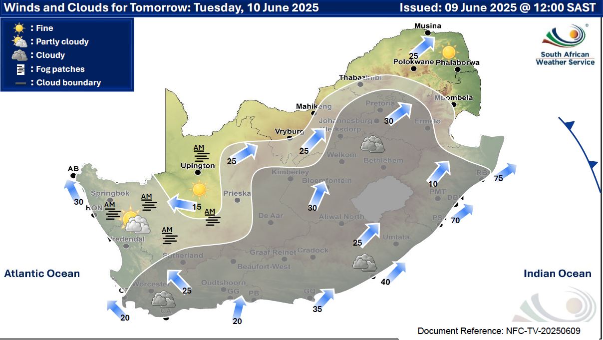
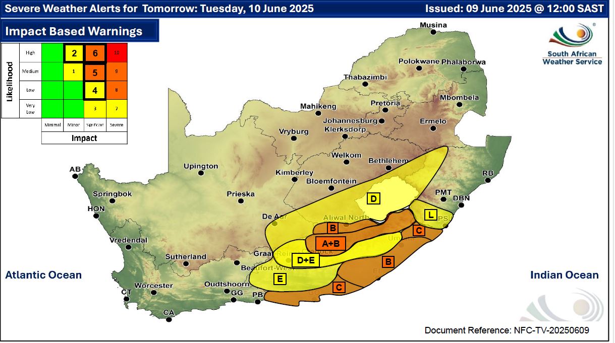
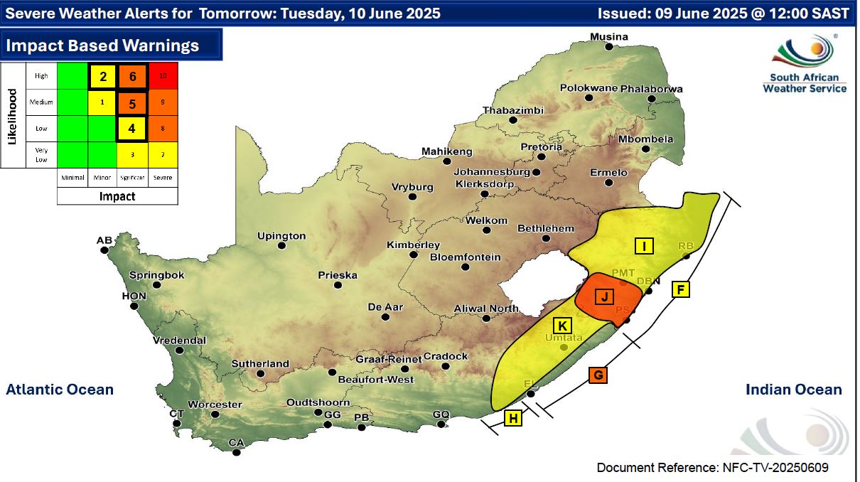
Maps for Tuesday 10 June
     Maps for Wednesday 11 June

|