
        Swipe left or right for more maps
Friday weather – a heat wave and damaging winds in the west, and more thunderstorm warningsBy Staff WriterPublished: 6 November 2025 [updated 7 November] This forecast is for: Fri 07 November 2025 The maps cover: Fri 07 Nov – Sun 09 Nov
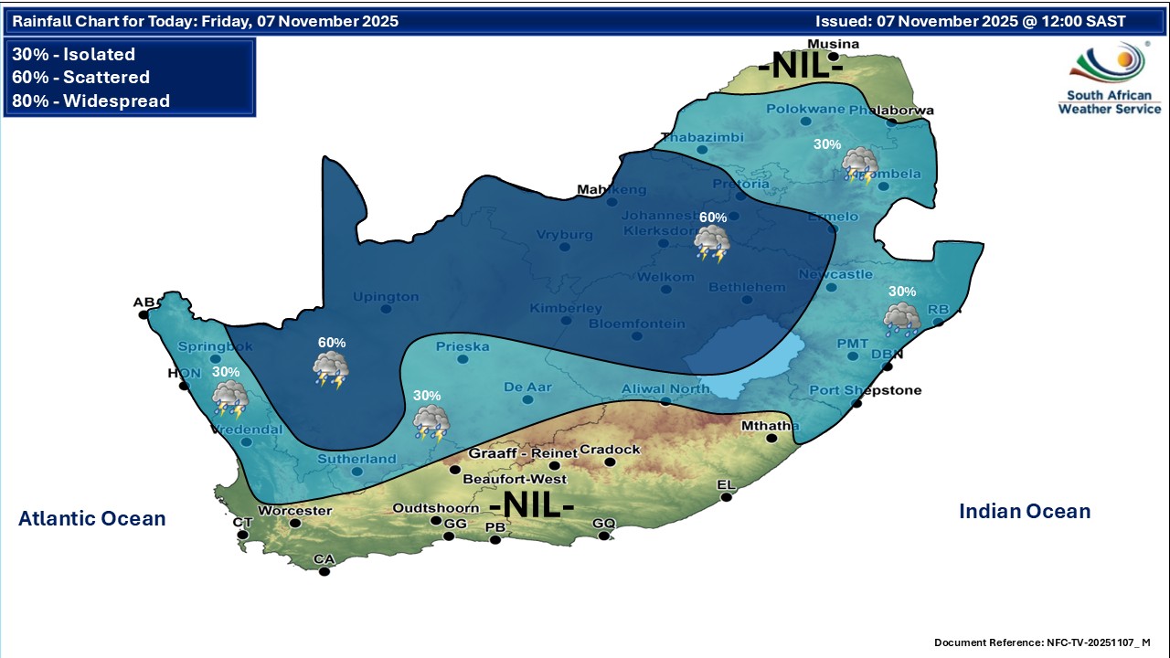
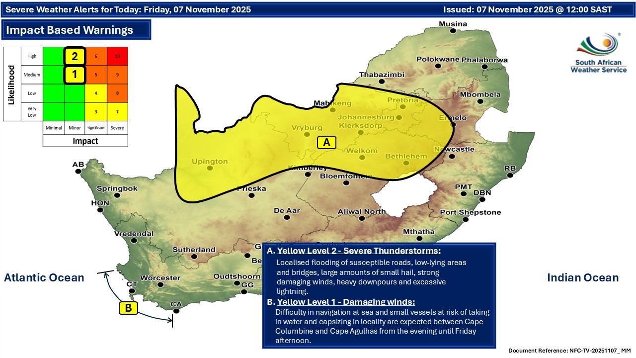
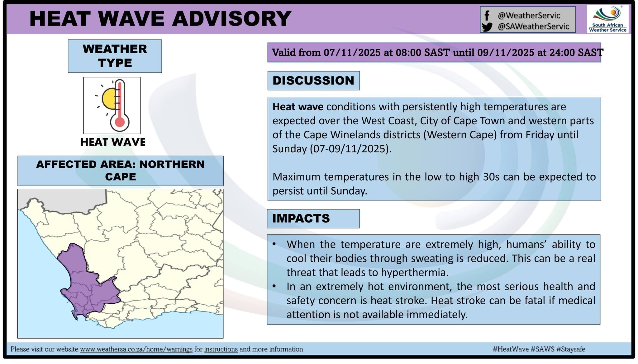
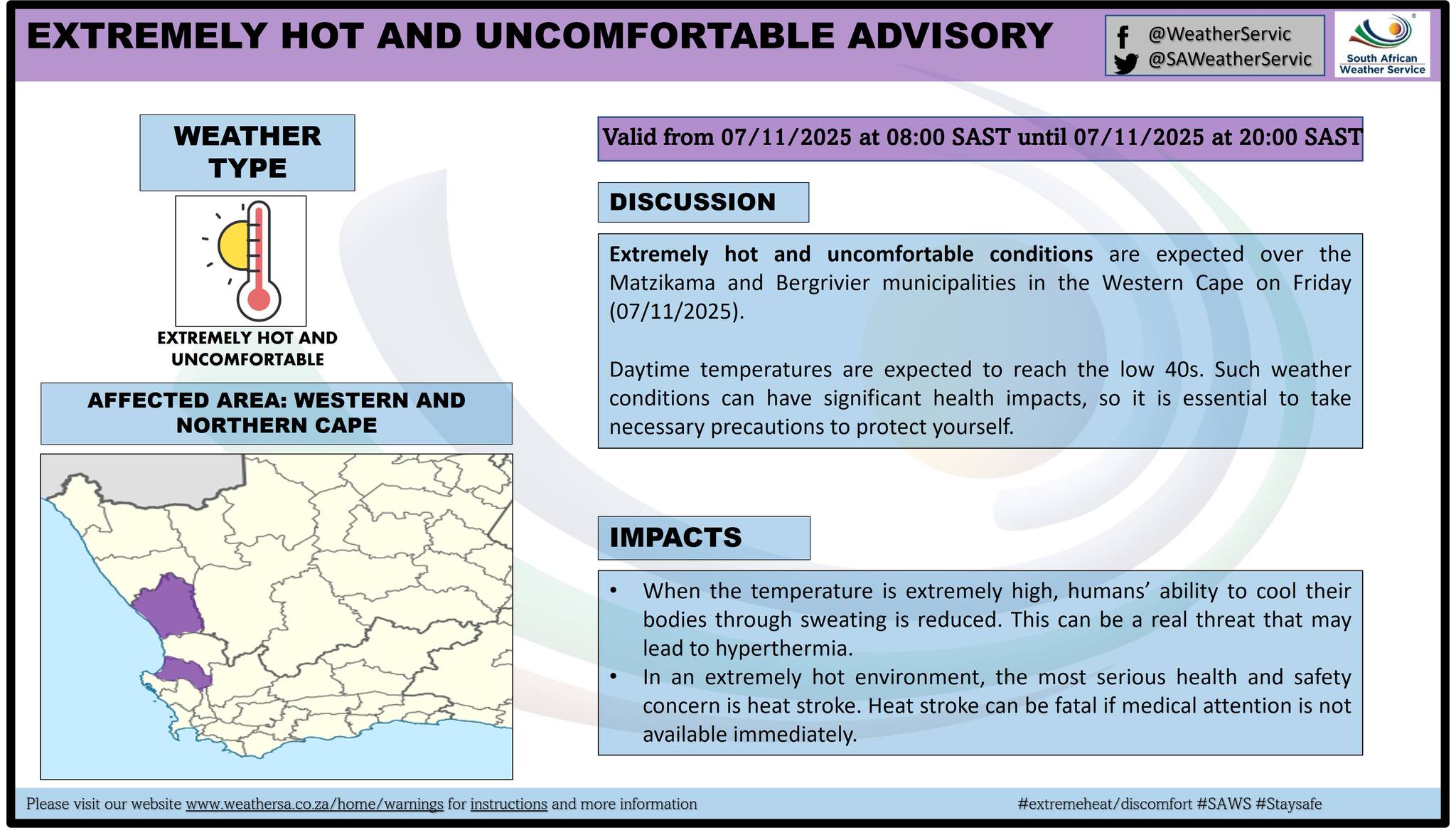
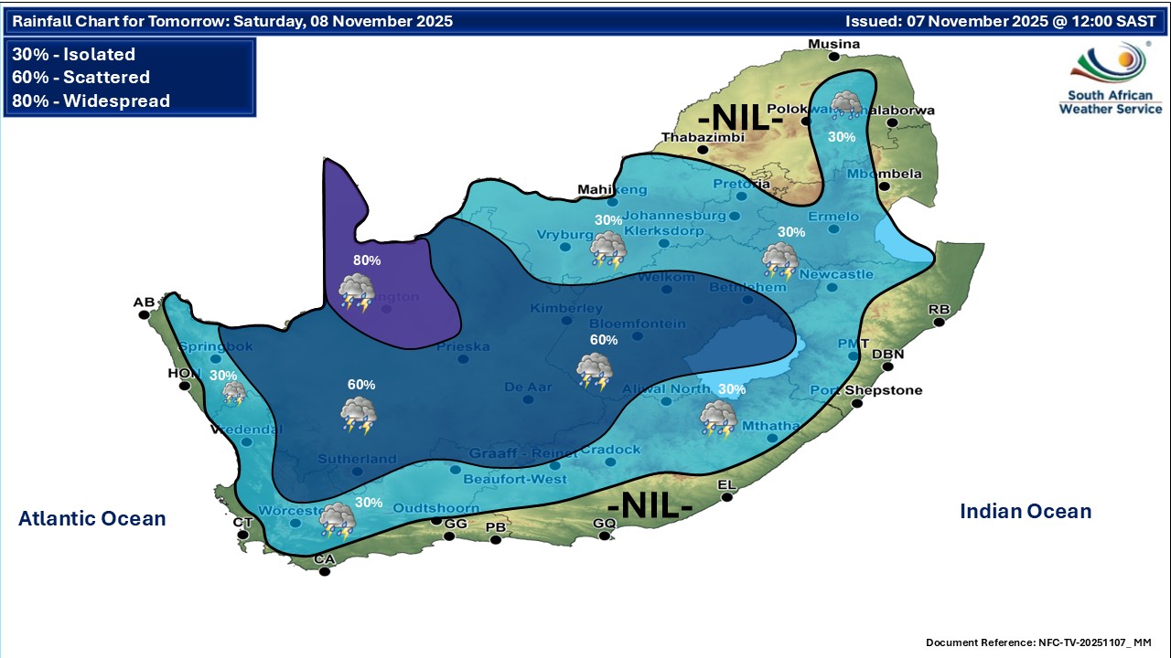
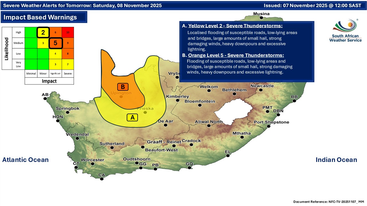
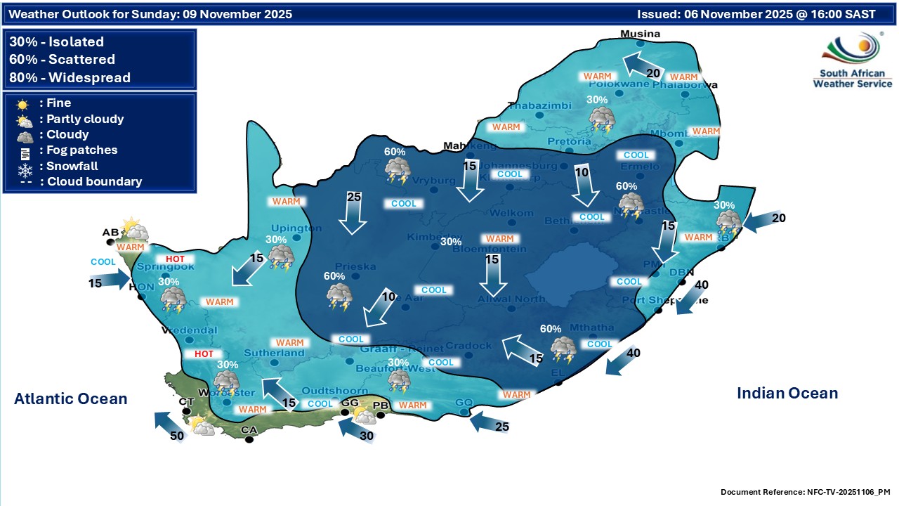
The latest forecast is available by clicking here. Partly cloudy and warm to cool with isolated to scattered showers and thundershowers possible over the central and eastern regions of the country on Friday, as well as morning fog in places. Cloudy and cool conditions are expected over the central and eastern parts of South Africa from Saturday with isolated to scattered showers and thundershowers possible. Otherwise, partly cloudy and warm. Warnings from the SA Weather Service for Friday: A. level 2 warning for severe thunderstorms accompanied by heavy downpours, damaging winds, large amounts of small hail and lightning leading to localized damage to infrastructure, settlements (informal), property, vehicles, livelihood, agricultural production and livestock, localized flooding of susceptible roads, low-lying areas and bridges, minor vehicle accidents, localized injuries due to flying debris over North West, Gauteng, Highveld of Mpumalanga, north-eastern parts of Northern Cape as well as most parts of the Free State, except in the south. B. level 1 warning for damaging winds leading to difficulty in navigation at sea and small vessels at risk of taking in water and capsizing in locality between Cape Columbine and Cape Agulhas. Regional forecasts from the SA Weather Service for Friday: GAUTENG Cloudy and cool with scattered showers and thundershowers. It will be cold in places in the south. The expected UVB sunburn index: High MPUMALANGA Morning fog patches along the escarpment, otherwise cloudy and cool to cold with isolated to scattered showers and thundershowers. LIMPOPO Morning fog patches along the escarpment, otherwise cloudy and cool to warm with isolated showers and thundershowers, but scattered in the extreme south-west. NORTH-WEST Cloudy and warm with scattered showers and thundershowers. THE FREE STATE Morning fog patches in the extreme east, otherwise cloudy and cool to warm with scattered showers and thundershowers, but isolated over the southern parts where it will be partly cloudy. THE NORTHERN CAPE Partly cloudy and warm, with scattered showers and thundershowers, but isolated over the western interior. The wind along the coast will be light to moderate westerly to north-westerly. THE WESTERN CAPE Fine and hot to very hot but extremely hot over parts of the West Coast District. It will be partly cloudy along the south coast. The wind along the coast will be moderate to fresh southerly to south-easterly but strong along the south-west and south coasts. The expected UVB sunburn index: Extreme THE WESTERN HALF OF THE EASTERN CAPE Partly cloudy and cool to warm, but fine over the interior. The wind along the coast will be moderate north-easterly. THE EASTERN HALF OF THE EASTERN CAPE Partly cloudy and cool with isolated showers and thundershowers. Morning drizzle is possible over the Wild coast. The wind along the coast will be moderate north-easterly. KWAZULU-NATAL Morning fog patches in places over the western interior, cloudy and cold to cool with isolated showers and rain. The wind along the coast will be light to moderate southerly to south-westerly until late morning, otherwise light south-easterly, becoming light to moderate easterly to north-easterly in the south from late afternoon, spreading northwards by the evening. The expected UVB sunburn index: Low Travellers forecasts from the SA Weather Service for Friday: PRETORIA Cloudy with scattered showers and thundershowers. Minimum/Maximum: 15/20°C The expected UVB Sunburn Index: High JOHANNESBURG Cloudy with scattered showers and thundershowers. Minimum/Maximum: 13/18°C VEREENIGING Cloudy with scattered showers and thundershowers. Minimum/Maximum: 13/17°C MBOMBELA Morning fog patches, otherwise cloudy with isolated showers and thundershowers. Minimum/Maximum: 15/17°C POLOKWANE Cloudy with isolated showers and thundershowers. Minimum/Maximum: 14/20°C MAHIKENG Cloudy, becoming cloudy with scattered showers and thundershowers. Minimum/Maximum: 15/23°C VRYBURG Cloudy with scattered showers and thundershowers. Minimum/Maximum: 16/26°C BLOEMFONTEIN cloudy with scattered showers and thundershowers. Minimum/Maximum: 15/25°C KIMBERLEY Cloudy with scattered showers and thundershowers. Minimum/Maximum: 17/28°C UPINGTON Partly cloudy with scattered showers and thundershowers. Minimum/Maximum: 20/34°C CAPE TOWN Fine Wind: Moderate to fresh southerly to south-easterly. Minimum/Maximum: 18/34°C The expected UVB Sunburn Index: Extreme GEORGE Partly cloudy. Wind: moderate to fresh easterly to south-easterly. Minimum/Maximum: 13/23°C GQEBERHA Partly cloudy. Wind: Moderate north-easterly. Minimum/Maximum: 16/21°C EAST LONDON Cloudy. Wind: Moderate north-easterly. Minimum/Maximum: 16/20°C DURBAN Cloudy with isolated showers and rain. Wind: Light to moderate north-easterly. Minimum/Maximum: 18/22°C The expected UVB Sunburn Index: Low RICHARDS BAY Cloudy with isolated showers and rain. Wind: Light to moderate south-easterly. Minimum/Maximum: 18/22°C PIETERMARITZBURG Morning fog patches, otherwise cloudy with isolated showers and rain. Minimum/Maximum: 13/17°C This forecast is usually updated a few times per day.
Please be sure to send photos and videos to us via whatsapp and also tell us where and when they were taken. Follow our channels
Maps for Saturday 8 November
  Maps for Sunday 9 November

|