
       Swipe left or right for more maps, and see below for others
Four weather warnings issued as the cold front arrives on SaturdayBy Staff WriterPublished: 6 June 2025 [updated 7 June] This forecast is for: Sat 07 June 2025 The maps cover: Sat 07 Jun – Mon 09 Jun
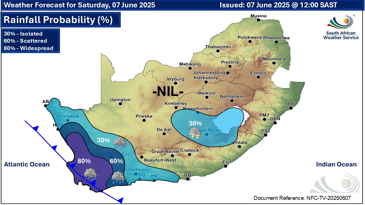
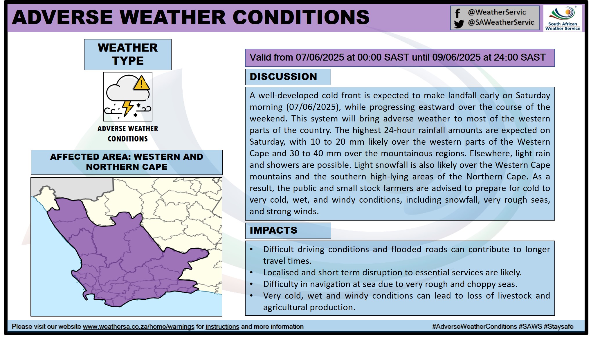
A newer forecast is available by clicking here. Very cold, wet and windy conditions are expected over the interior of the Western Cape and Namakwa district of the Northern Cape from Saturday into Monday, and over the Eastern Cape from Sunday into Wednesday, snowfall can be expected over high-lying areas and mountain peaks leading to icy road conditions especially over the Beaufort West municipality of the Western Cape on Sunday evening, spreading into the Eastern Cape high ground, south-western and western high ground of KwaZulu-Natal as well as extreme eastern and southern parts of Free State on Monday. ALSO READ: Widespread snowfall possible for South Africa and Lesotho – low-level and disruptive for some regions. Warnings from the SAWS from Saturday: A. level 4 warning for disruptive rainfall leading to flooding and difficult driving conditions over the City of Cape Town, Cape Winelands, western parts of Overberg and the southern parts of the West Coast District of the western cape on Saturday into Sunday. B. level 2 warning for damaging waves leading to difficulty in navigation at sea between Saldanha Bay and Cape Agulhas on Saturday spreading to Plettenberg Bay from Sunday into Monday. C. level 1 warning for damaging winds leading to localised disruptions to small harbours and ports for short periods between Saldanha Bay and Cape Agulhas. D. level 1 warning for damaging interior winds resulting in localised power and communication interruptions as well as problems for high-sided vehicles on prone routes in places over Joe Gqabi and Chris Hani district municipalties of the Eastern Cape. Regional forecasts from SAWS for Saturday: 1. GAUTENG Morning frost in places, with fog patches in the south, otherwise fine and cool. The expected UVB sunburn index: Moderate 2. MPUMALANGA Morning fog over the highveld, otherwise fine and cool to warm. 3. LIMPOPO Partly cloudy in the north, otherwise fine and cool to warm. 4. NORTH WEST Fine, windy and cool, but partly cloudy in the west. 5. FREE STATE Partly cloudy, windy and cool, with isolated showers and thundershowers in the south-west. 6. NORTHERN CAPE Partly cloudy, windy and cool to warm, with isolated showers and thundershowers in places in the south-east and west, but scattered in the south-west. The wind along the coast will be moderate to fresh north-westerly. 7. WESTERN CAPE Cloudy, windy and cold with scattered to widespread showers and rain, but cool with isolated showers in the east. It will be partly cloudy in the north-east. The wind along the coast will be moderate to fresh west to north-westerly, but strong to near-gale force along the south-west coast in the morning. The expected UVB sunburn index: Low 8. WESTERN HALF OF THE EASTERN CAPE Partly cloudy, windy and cool, becoming cloudy with isolated showers and rain along the coast to the west of Cape St Francis in the evening. The wind along the coast will be moderate to fresh south-westerly. 9. EASTERN HALF OF THE EASTERN CAPE Partly cloudy, windy and cool with isolated thundershowers north of the escarpment. The wind along the coast will be light northerly to north-westerly becoming moderate to fresh south-westerly early afternoon. 10. KWAZULU-NATAL Partly cloudy and warm but cool in the west. It will be fine in the north. The wind along the coast will be light to moderate northerly to north-easterly but fresh in the north, becoming south-westerly in the south in the evening. The expected UVB sunburn index: Extreme Travellers forecasts from SAWS for Saturday: PRETORIA Fine. Minimum/Maximum: 7/21°C The expected UVB Sunburn Index: Moderate JOHANNESBURG Morning fog patches, otherwise fine. Minimum/Maximum: 6/20°C VEREENIGING Morning fog patches, otherwise fine. Minimum/Maximum: 3/21°C MBOMBELA Fine. Minimum/Maximum: 10/25°C POLOKWANE Fine. Minimum/Maximum: 6/21°C MAHIKENG Fine and windy. Minimum/Maximum: 9/22°C VRYBURG Partly cloudy and windy. Minimum/Maximum: 10/22°C BLOEMFONTEIN Partly cloudy and windy. Minimum/Maximum: 9/22°C KIMBERLEY Partly cloudy and windy. Minimum/Maximum: 12/23°C UPINGTON Partly cloudy and windy. Minimum/Maximum: 12/24°C CAPE TOWN Cloudy with widespread showers and rain. Wind: Moderate to fresh north-westerly. Minimum/Maximum: 11/15°C The expected UVB Sunburn Index: Low GEORGE Cloudy with evening rain. Wind: Moderate to fresh north-westerly. Minimum/Maximum: 11/20°C GQEBERHA Cloudy. Wind: Light north-westerly becoming moderate to fresh south-westerly late morning. Minimum/Maximum: 13/22°C EAST LONDON Partly cloudy. Wind: Light northerly to north-westerly becoming moderate to fresh south-westerly early afternoon. Minimum/Maximum: 15/23°C DURBAN Partly cloudy. Wind: Moderate north-easterly. Minimum/Maximum: 19/28°C The expected UVB Sunburn Index Extreme RICHARDS BAY Partly cloudy. Wind: Light to moderate northerly to north-easterly. Minimum/Maximum: 18/31°C PIETERMARITZBURG Partly cloudy. Minimum/Maximum: 12/27°C This forecast is usually updated a few times per day.
Please be sure to send photos and videos to us via whatsapp and also tell us where and when they were taken. Follow our channels
Maps for Sunday 8 June
   Maps for Monday 9 June

|