
      Swipe left or right for more maps, and see below for others
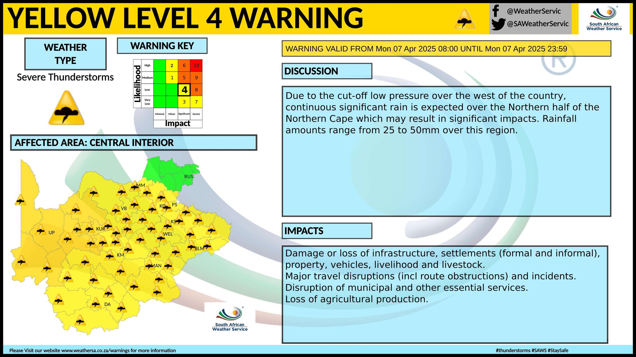
Cut-off low: Level 4 warning for severe thunderstorms and flooding in the Northern Cape on MondayBy Staff WriterPublished: 6 April 2025 [updated 7 April] This forecast is for: Mon 07 April 2025 The maps cover: Mon 07 Apr – Tue 08 Apr
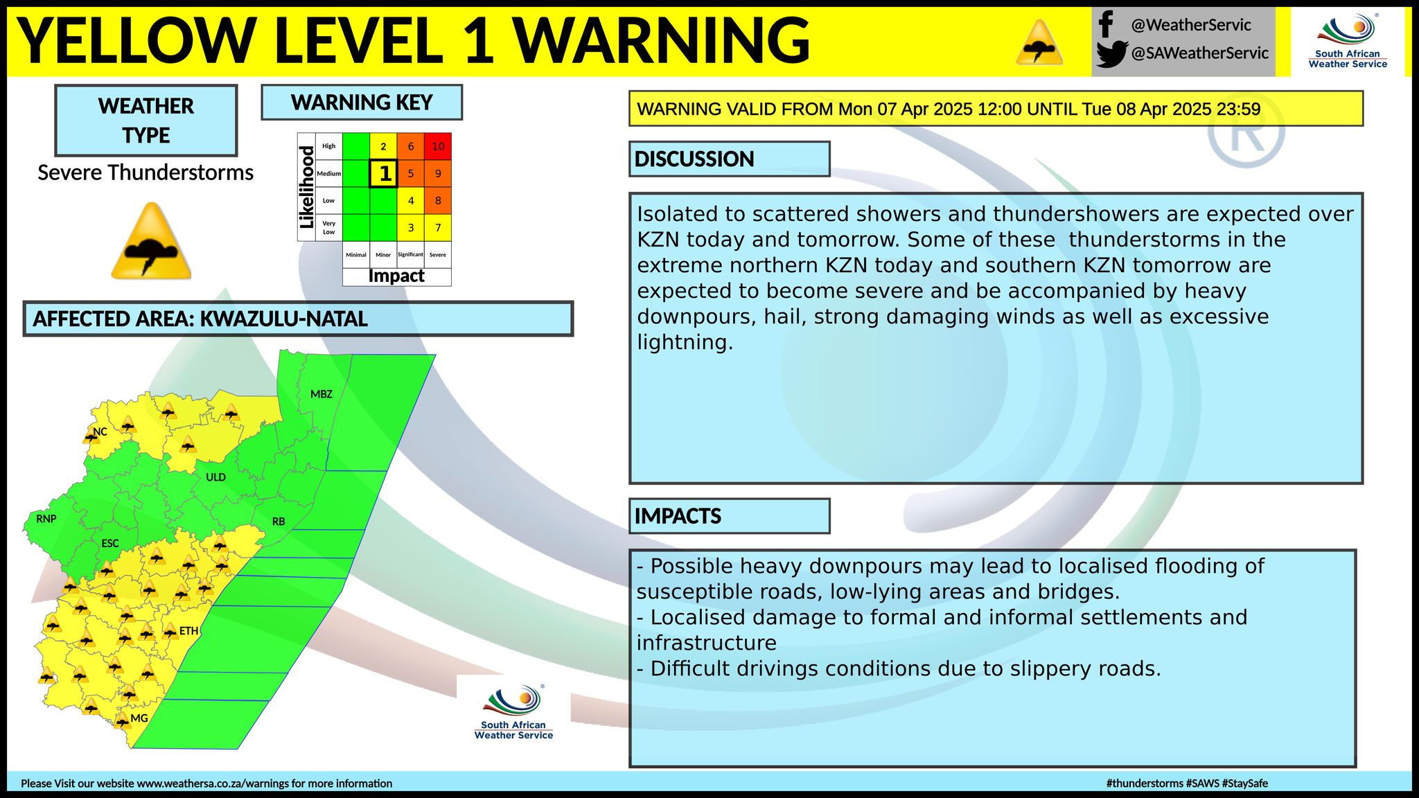
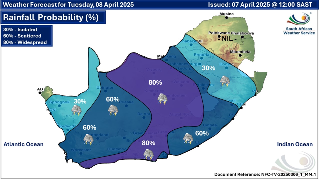
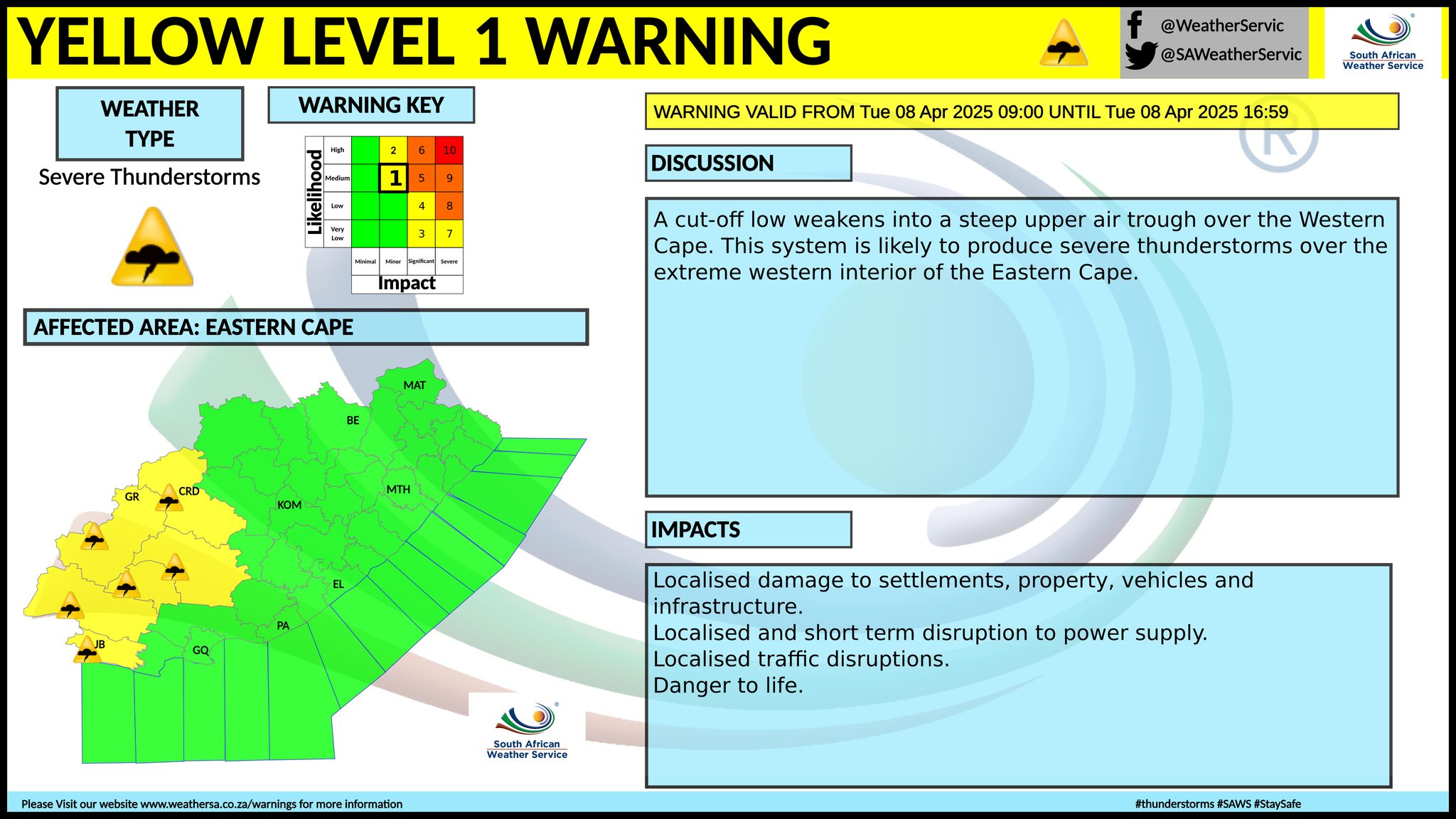
A newer forecast is available by clicking here. Isolated to scattered showers and thundershowers in most parts of the country but widespread over the central interior on Monday, spreading to the southern parts on Tuesday, according to the SA Weather Service. A cut-off low pressure over the west of the country is expected to deliver continuous significant rain (25mm-50mm) over the Northern half of the Northern Cape and this may result in significant impacts, including major travel disruptions. Temperatures are set to drop from Tuesday across much of the country. Warnings from the SA Weather Service for Monday: A. yellow level 4 warning severe thunderstorms with heavy downpours leading to flooding of settlements (formal/informal), road flooding, low-lying areas, bridges, danger to livelihood and livestock as well as damage to properly and infrastructure is expected over the northern and North-Eastern parts of Northern Cape. B. yellow level 2 warning severe thunderstorms resulting in heavy downpours leading to localised flooding of susceptible roads, low-lying areas and bridges as well as damage to property and infrastructure is expected over parts of the Northern Cape, Free State, North West, the Eastern Cape, Mpumalanga and KwaZulu-Natal as per the updated map above. Regional forecasts from SAWS for Monday: 1. GAUTENG Cloudy and cool to warm with isolated showers and thundershowers in the extreme south. The expected UVB sunburn index: Very High 2. MPUMALANGA Morning fog in places on the highveld and escarpment, otherwise cloudy and cool to warm with isolated showers and thundershowers in the southern Highveld and along the escarpment. It will be partly cloudy in the Lowveld. 3. LIMPOPO Morning fog in places in the east, otherwise partly cloudy and warm with a chance of light morning rain along the southern escarpment. 4. NORTH WEST PROVINCE Cloudy and cool to warm with scattered showers and thundershowers but isolated in the north-east. 5. FREE STATE Cloudy and cool with scattered showers and thundershowers, but widespread in the west. 6. NORTHERN CAPE Morning fog along the coast, otherwise cloudy and cool to warm with scattered to widespread showers and thundershowers, but isolated in the extreme west. The wind along the coast will be moderate north-westerly. 7. WESTERN CAPE Morning fog along the west coast, otherwise cloudy and cool to warm with isolated showers and thundershowers, except in the extreme south-west but scattered in the extreme north and north-east. It will be partly cloudy in the south. The wind along the coast will be moderate to fresh easterly. The expected UVB sunburn index: Very High 8. WESTERN HALF OF THE EASTERN CAPE Partly cloudy along the coast and adjacent interior, otherwise cloudy and warm with isolated showers and thundershowers but scattered in the north. The wind along the coast will be moderate to fresh north-easterly. 9. EASTERN HALF OF THE EASTERN CAPE Cloudy and cool to warm with isolated to scattered showers and thundershowers, except along the coast where it will be partly cloudy. The wind along the coast will be moderate to fresh north-easterly. 10. KWAZULU-NATAL Morning fog over the western interior, otherwise cloudy and cool to warm with isolated showers and thundershowers, except in the north-east. The wind along the coast will be moderate to fresh north-easterly. The expected UVB sunburn index: Very High Travellers forecasts from SAWS for Monday: PRETORIA Cloudy at times. Minimum/Maximum: 18/24°C The expected UVB Sunburn Index: Very High JOHANNESBURG Cloudy at times. Minimum/Maximum: 14/21°C VEREENIGING Cloudy with isolated showers and thundershowers. Minimum/Maximum: 16/21°C MBOMBELA Partly cloudy with isolated showers and thundershowers. Minimum/Maximum: 16/24°C POLOKWANE Partly cloudy. Minimum/Maximum: 16/26°C MAHIKENG Cloudy with scattered showers and thundershowers. Minimum/Maximum: 17/24°C VRYBURG Cloudy with scattered showers and thundershowers. Minimum/Maximum: 17/23°C BLOEMFONTEIN Cloudy with widespread showers and thundershowers. Minimum/Maximum: 15/20°C KIMBERLEY Cloudy with widespread showers and thundershowers. Minimum/Maximum: 16/21°C UPINGTON Cloudy with widespread showers and thundershowers. Minimum/Maximum: 18/25°C CAPE TOWN Morning fog, otherwise cloudy at times. Wind: Moderate to fresh easterly. Minimum/Maximum: 19/24°C The expected UVB Sunburn Index: Very High GEORGE Partly cloudy. Wind: Moderate to fresh easterly. Minimum/Maximum: 16/27°C GQEBERHA Partly cloudy. Wind: Fresh north-easterly. Minimum/Maximum: 18/26°C EAST LONDON Partly cloudy. Wind: Fresh north-easterly. Minimum/Maximum: 18/28°C DURBAN Cloudy with isolated showers and thundershowers. Wind: Moderate north-easterly. Minimum/Maximum: 21/27°C The expected UVB Sunburn Index: Very High RICHARDS BAY Cloudy at times. Wind: Fresh north-easterly. Minimum/Maximum: 21/31°C PIETERMARITZBURG Morning fog, otherwise cloudy with isolated showers and thundershowers. Minimum/Maximum: 15/26°C This forecast is usually updated a few times per day.
Please be sure to send photos and videos to us via whatsapp and also tell us where and when they were taken. Follow our channels
Maps for Tuesday 8 April
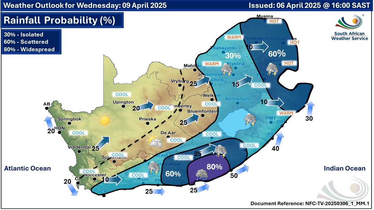
   Maps for Wednesday 9 April
|