
FRIDAY WEATHER: Widespread rain, severe thunderstorms up to LEVEL 5 and damaging coastal wind and waves
By Staff WriterPublished: 5 March 2026 [updated 6 March]
This forecast is for: Fri 06 March 2026
The maps cover: Fri 06 Mar – Fri 06 Mar
| SHARE TO |
The latest forecast is available by clicking here.
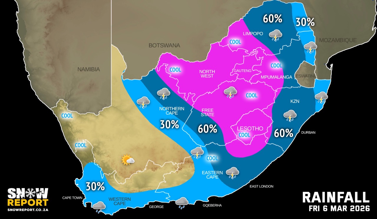
A sustained spell of tropically sourced rainfall is on the cards for a large part of southern Africa, especially over the central and eastern interior in the coming days and extending through the weekend. Thunderstorms are also expected to accompany the rain, with some of these storms expected to become severe, associated with heavy downpours and a distinct risk of localised flooding according to the SA Weather Service.
A cold front is expected to move eastwards along the south coast from Friday evening, with a strong high-pressure system ridging in behind it from the south-west. Consequently, strong to near gale-force south-westerly winds of 50-60 km/h, gusting 62-70 km/h are expected between Cape Point and Plettenberg Bay until Saturday evening. Wave heights are expected to reach 4-4.5m.
Hot to very hot and humid weather can be expected over the eastern parts of KwaZulu-Natal.
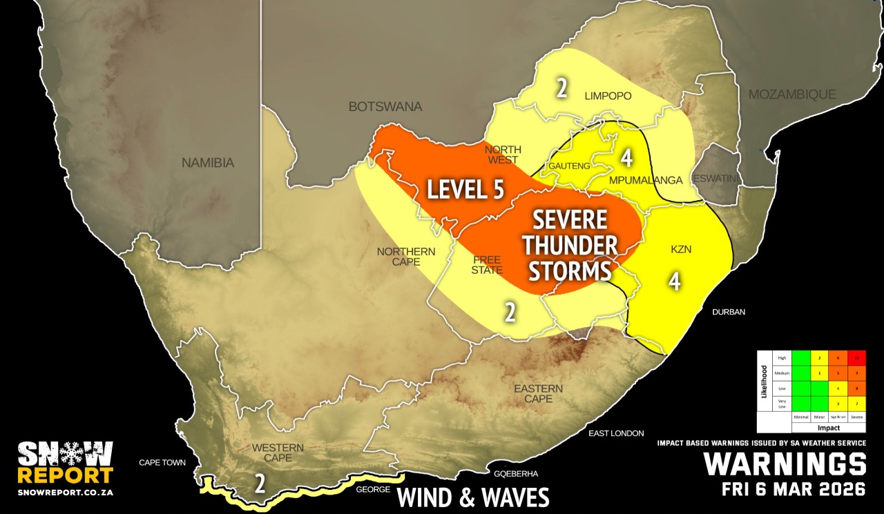
Warnings from the SA Weather Service for Friday:
A. level 5 warning for severe thunderstorms with heavy downpours leading to flooding of roads, settlements and low-lying areas, as well as damaging winds, large amounts of small hail and excessive lighting over the north-eastern parts of Northern Cape, western parts of North West, as well as the central and eastern parts of Free State.
B. level 4 warning for severe thunderstorms with heavy downpours leading to localised flooding of susceptible roads, settlements, low-lying bridges/areas, as well as possible strong damaging winds, hail, and excessive lightning over the central north-east of the Northern Cape, south-western parts of Free Stare, eastern parts of North West, Gauteng, western Highveld of Mpumalanga, as well as parts of KwaZulu-Natal (except for the extreme north-east).
C. level 2 warning for severe thunderstorms with heavy downpours leading to localised flooding of susceptible roads, settlements, low-lying bridges/areas, hail, and excessive lightning over the south-western parts of Limpopo, as well as the eastern Highveld and escarpment areas of Mpumalanga.
C. level 2 warning for damaging winds and waves leading to small vessels taking on water and capsizing in a locality and difficulty in navigation at sea between Cape Point and Plettenberg Bay from the evening, into Saturday.
Regional forecasts from the SA Weather Service for Friday:
GAUTENG
Cloudy and cool with widespread showers and thundershowers.
MPUMALANGA
Cloudy and cool to warm with scattered to widespread showers and thundershowers but isolated in the Lowveld, where it will be hot.
LIMPOPO
Cloudy and warm to hot with scattered to widespread showers and thundershowers but isolated in the Lowveld and Limpopo Valley.
NORTH-WEST
Cloudy and cool, with widespread showers and thundershowers.
THE FREE STATE
Cloudy and cool to warm with scattered to widespread showers and thundershowers.
THE NORTHERN CAPE
Fog along the coast in the morning, where it will be cloudy, otherwise partly cloudy and cool to warm, becoming fine over the central interior by the afternoon. It will be partly cloudy with isolated to scattered showers and thundershowers in the north-east but widespread in the extreme north-east. The wind along the coast will be light to moderate northerly to north-westerly, becoming moderate southerly to south-westerly in the evening.
THE WESTERN CAPE
Cloudy to partly cloudy and cool to warm but hot over Beaufort West municipality with isolated showers and rain over the south and south-western parts from the afternoon, but fine overt the central parts in the morning. The wind along the coast will be moderate to fresh northerly to north-westerly along the west coast, but light and variable along the south coast until the afternoon. It will become fresh to strong south-westerly to westerly along the south-west and southern coast from the evening spreading to west coast by the end of the period.
THE WESTERN HALF OF THE EASTERN CAPE
Partly cloudy and warm with light morning rain in places. The wind along the coast will be light south-westerly, becoming light south-easterly in the afternoon but moderate south-westerly overnight.
THE EASTERN HALF OF THE EASTERN CAPE
Cloudy to partly cloudy and warm with scattered showers and thundershowers, clearing from the west in the afternoon. The wind along the coast will be light and variable, becoming light southerly from late morning.
KWAZULU-NATAL
Morning fog in places, otherwise cloudy and warm to hot with solated to scattered showers and thundershowers, but widespread in the west and south. The wind along the coast will be light to moderate westerly to south-westerly between Port Edward and Durban, where it will become moderate to fresh south-westerly to southerly in the afternoon, otherwise moderate to fresh northerly to north-easterly, becoming strong in the afternoon. It will then become moderate to fresh south-westerly to southerly between Port Edward and Durban in the afternoon.
Travellers forecasts from the SA Weather Service for Friday:
PRETORIA
Cloudy with widespread showers and thundershowers.
Minimum/Maximum: 17/20°C
JOHANNESBURG
Cloudy with widespread showers and thundershowers.
Minimum/Maximum: 15/18°C
VEREENIGING
Cloudy with widespread showers and thundershowers.
Minimum/Maximum: 17/19°C
MBOMBELA
Cloudy with scattered showers and thundershowers.
Minimum/Maximum: 19/27°C
POLOKWANE
Cloudy with scattered showers and thundershowers.
Minimum/Maximum: 18/25°C
MAHIKENG
Cloudy with widespread showers and thundershowers.
Minimum/Maximum: 17/22°C
VRYBURG
Cloudy with widespread showers and thundershowers.
Minimum/Maximum: 17/24°C
BLOEMFONTEIN
Cloudy with scattered showers and thundershowers.
Minimum/Maximum: 17/21°C
KIMBERLEY
Cloudy with scattered showers and thundershowers.
Minimum/Maximum: 18/26°C
UPINGTON
Partly cloudy.
Minimum/Maximum: 20/29°C
CAPE TOWN
Partly cloudy with early morning fog. It will become cloudy with isolated showers and rain from the afternoon.
Wind: Light and variable, but moderate north-westerly from the afternoon. It will become moderate south-westerly from the evening.
Minimum/Maximum: 17/22°C
GEORGE
Partly cloudy with isolated showers and rain.
Wind: Light and variable, becoming moderate westerly from the late evening.
Minimum/Maximum: 16/24°C
GQEBERHA
Cloudy with isolated showers and rain.
Wind: Light south-westerly, becoming light south-easterly in the afternoon.
Minimum/Maximum: 19/23°C
EAST LONDON
Cloudy with scattered showers and rain.
Wind: Light and variable, becoming light southerly from late morning.
Minimum/Maximum: 21/24°C
DURBAN
Cloudy with widespread showers and thundershowers.
Wind: Light to moderate northerly to north-easterly, becoming moderate to fresh southerly to south-westerly from afternoon.
Minimum/Maximum: 24/32°C
RICHARDS BAY
Partly cloudy with isolated afternoon showers and thundershowers.
Wind: Moderate to fresh north-easterly, strengthening in the afternoon.
Minimum/Maximum: 25/35°C
PIETERMARITZBURG
Morning fog, otherwise partly cloudy, becoming cloudy from late
morning with widespread showers and thundershowers.
Minimum/Maximum: 20/30°C
This forecast is usually updated a few times per day.
| SHARE TO |
Please be sure to send photos and videos to us via whatsapp and also tell us where and when they were taken.
Follow our channels