
     Swipe left or right for more maps, and see below for others
More weather warnings issued for a very cold Sunday with disruptive snowfallBy Staff WriterPublished: 5 July 2025 [updated 6 July] This forecast is for: Sun 06 July 2025 The maps cover: Sun 06 Jul – Tue 08 Jul
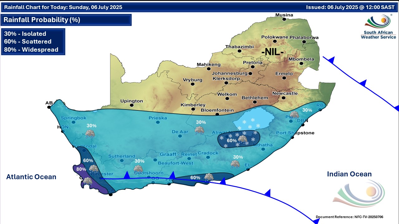
A newer forecast is available by clicking here. You can listen to this daily weather forecast as a 4 minute podcast by pressing the > play button above. Very cold conditions are expected on Sunday morning over the Free State, North West and eastern parts of Northern Cape. From Monday partly cloudy conditions are expected over the north eastern, southern and eastern parts of the country, with isolated rain and showers expected in the southern and eastern regions. Otherwise, fine and cold to very cold, but cool in places the north. ALSO READ: Snowfall continues in four SA provinces and Lesotho on Saturday and Sunday. Warnings from the SA Weather Service for Sunday: A. level 4 warning for disruptive rainfall leading to flooding of roads and danger to life due to fast flowing streams over low-lying bridges over the City of Cape Town, Cape Winelands, West Coast and Overberg Districts of the Western Cape. B. level 2 warning for damaging waves resulting in difficulty in navigation at sea between Cape Agulhas and East London on Saturday until Monday morning. C. level 2 warning for damaging winds resulting in small vessels at risk of taking on water and capsizing in a locality as well as difficulty in navigation between Plettenberg Bay and East London. D. level 2 warning for disruptive snow resulting in some minor streams inaccessible for drinking water in rural areas and isolated loss of vulnerable livestock and crops in places over the northern high-lying areas of the Eastern Cape. Extremely high fire danger conditions are expected over the extreme south-eastern parts of Limpopo. Regional forecasts from the SA Weather Service for Sunday: 1. GAUTENG Fine and cool. The expected UVB sunburn index: High 2. MPUMALANGA Fine and cool to cold, but warm in the Lowveld. 3. LIMPOPO Fine and cool to warm. 4. NORTH WEST PROVINCE Fine, windy and cold to cool, becoming partly cloudy over the extreme south-west in the afternoon. 5. FREE STATE Fine in the north-east, otherwise cloudy to partly cloudy, windy and cold to very cold, with isolated showers and thundershowers, except the north and the north-eastern parts. Light snow can be expected in the extreme south. 6. NORTHERN CAPE Cloudy, windy and cold, with isolated showers and thundershowers except in the extreme north and the north-eastern parts where it will be partly cloudy. Light snow can be expected in the extreme south-east. The wind along the coast will be moderate to fresh northerly to north-westerly. 7. WESTERN CAPE Cloudy with scattered to isolated showers and rain, but widespread over the extreme south-western parts. The wind along the coast will be moderate to fresh westerly to south-westerly, but strong to near gale along the south. The expected UVB sunburn index: Low 8. WESTERN HALF OF THE EASTERN CAPE Cloudy and cold to very cold with isolated showers and rain, but scattered along the coast and adjacent interior. Snowfalls are expected over the high-lying areas. The wind along the coast will be fresh to strong south-westerly. 9. EASTERN HALF OF THE EASTERN CAPE Cloudy and cold to very cold, but cool along the coast with isolated showers and rain with snowfalls over the northern high-lying areas. The wind along the coast will be fresh to strong south-westerly. 10. KWAZULU-NATAL Fine in the extreme north-west, otherwise partly cloudy and cool to warm but cold in the south-west. Isolated showers and rain are expected in the south. The wind along the coast will be light and moderate westerly to north-westerly but fresh in the north, becoming moderate to fresh southerly to south-westerly in the south from late morning, spreading to the north late afternoon. The expected UVB sunburn index: High Travellers forecasts from the SA Weather Service for Sunday: PRETORIA Fine. Minimum/Maximum: 4/19°C The expected UVB Sunburn Index: High JOHANNESBURG Fine. Minimum/Maximum: 2/18°C VEREENIGING Fine. Minimum/Maximum: 2/17°C MBOMBELA Fine. Minimum/Maximum: 6/27°C POLOKWANE Fine. Minimum/Maximum: 6/24°C MAHIKENG Fine and windy. Minimum/Maximum: 2/18°C VRYBURG Fine and windy. Minimum/Maximum: -2/16°C BLOEMFONTEIN Cloudy and windy with isolated showers. Minimum/Maximum: 0/12°C KIMBERLEY Cloudy and windy with isolated showers. Minimum/Maximum: -1/12°C UPINGTON Cloudy and windy with isolated showers. Minimum/Maximum: 3/13°C CAPE TOWN Cloudy with widespread showers and rain. Wind: Light northerly. Minimum/Maximum: 11/13°C The expected UVB Sunburn Index: Low GEORGE Cloudy with isolated showers and rain in the afternoon. Wind: Moderate to fresh westerly to north-westerly. Minimum/Maximum: 9/15°C GQEBERHA Cloudy with scattered showers and rain. Wind: Fresh to strong south-westerly. Minimum/Maximum: 11/16°C EAST LONDON Cloudy with isolated showers and rain. Wind: Fresh to strong south-westerly. Minimum/Maximum: 12/19°C DURBAN Fine, becoming partly cloudy from the afternoon with isolated evening showers and rain. Wind: Light westerly to north-westerly, becoming light to moderate southerly to south-westerly from the afternoon. Minimum/Maximum: 12/22°C The expected UVB Sunburn Index: High RICHARDS BAY Fine, becoming partly cloudy from late afternoon with isolated evening showers and rain. Wind: Light north-westerly, becoming light to moderate southerly to south-westerly from the afternoon. Minimum/Maximum: 11/25°C PIETERMARITZBURG Fine, becoming partly cloudy from the afternoon with isolated evening showers and rain. Minimum/Maximum: 5/21°C This forecast is usually updated a few times per day.
Please be sure to send photos and videos to us via whatsapp and also tell us where and when they were taken. Follow our channels
Maps for Monday 7 July
  Maps for Tuesday 8 July

|