
     Swipe left or right for more maps, and see below for others
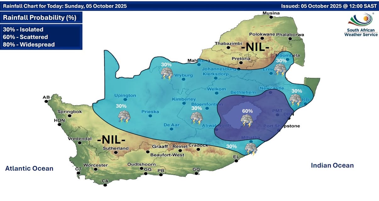
A severe thunderstorm warning for KZN on Sunday and more damaging wind warningsBy Staff WriterPublished: 4 October 2025 [updated 5 October] This forecast is for: Sun 05 October 2025 The maps cover: Sun 05 Oct – Tue 07 Oct
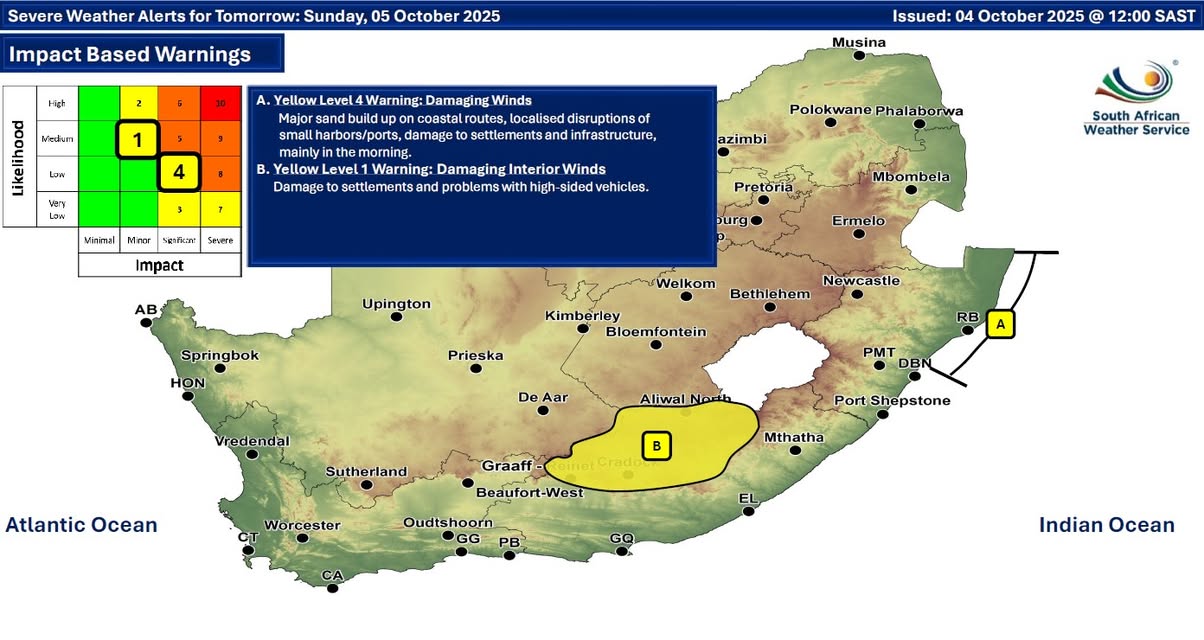
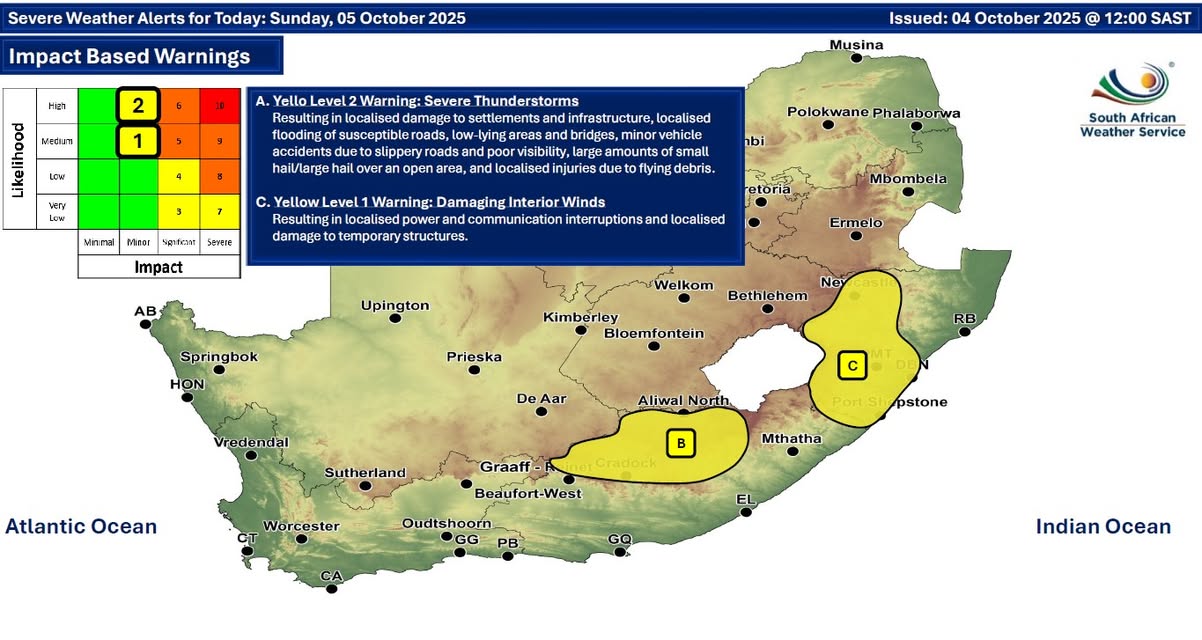
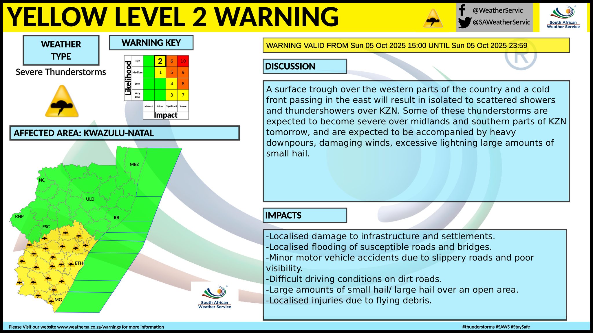
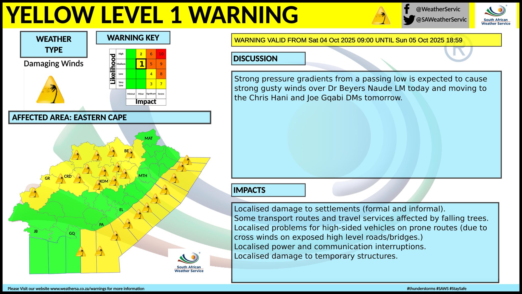
A newer forecast is available by clicking here. A surface trough over the western parts of the country and a cold front passing in the east will result in isolated to scattered showers and thundershowers over KwaZulu-Natal on Sunday. Warnings from the SA Weather Service for Sunday: A. level 4 warning for damaging winds leading to major build-up of sand on coastal routes, localised disruption of small harbours or ports and damage of settlements and infrastructure along the coast and adjacent interior between Mtunzini and Kosi Bay, mainly in the morning. B. level 1 warning for damaging interior winds resulting in localised power and communication interruptions and localised damage to temporary structures are expected in places over Chris Hani and Joe Gqabi District Municipalities. level 2 warning for severe thunderstorms leading to localised damage to settlements and infrastructure, localised flooding of susceptible roads, low-lying areas and bridges, minor vehicle accidents due to slippery roads and poor visibility, large amounts of small hail/large hail over an open area, and localised injuries due to flying debris, are expected over the midlands and southern parts of KwaZulu-Natal from the late afternoon. Extremely high fire danger conditions are expected in places over Northern Cape, Free State, North West, as well as Sarah Baartman and Chris Hani. Regional forecasts from the SA Weather Service for Sunday: GAUTENG Fine and warm but partly cloudy in the south with isolated showers and thundershowers in the afternoon. The expected UVB sunburn index: Very High MPUMALANGA Cloudy in the north with fog patches along the escarpment in the morning, otherwise partly cloudy and cool to warm with isolated showers and thundershowers in the south and along the escarpment. LIMPOPO Cloudy in the morning with fog patches along the escarpment, otherwise fine and warm but hot in the east. NORTH-WEST Partly cloudy, windy and warm to hot, with isolated showers and thundershowers except in the extreme north-east, where it will be fine. THE FREE STATE Cool in the east, otherwise partly cloudy and warm with isolated showers and thundershowers but scattered along the Lesotho border. THE NORTHERN CAPE Cloudy in the west at first where it will be cold in places, otherwise partly cloudy and cool to warm with isolated showers and thundershowers in the north, central and eastern interior, becoming fine in the central and western parts from the afternoon. Wind along the coast will be light and variable, becoming moderate to fresh southerly to south-westerly by the afternoon. THE WESTERN CAPE Cloudy to partly cloudy and cool to cold with isolated showers and rain in the west and south-western parts in the morning, becoming fine over the eastern parts from the afternoon. The wind along the coast will be moderate to fresh westerly to south-westerly, but strong in places along the south coast, becoming strong north-westerly along the south-west coast from the afternoon, reaching gale in the evening. The expected UVB sunburn index: Very High THE WESTERN HALF OF THE EASTERN CAPE Partly cloudy and cool. The wind along the coast will be fresh to strong south-westerly. THE EASTERN HALF OF THE EASTERN CAPE Partly cloudy and cool with isolated afternoon thundershowers over the interior but scattered in the north. The wind along the coast will be Moderate to fresh south-westerly. KWAZULU-NATAL Morning fog patches in places over the northern interior, otherwise partly cloudy to cloudy and cool to warm. Scattered showers and thundershowers are expected over the western and southern parts, otherwise isolated, except in the extreme north-east. The wind along the coast will be light to moderate northerly to north-easterly, reaching fresh to strong in the north, becoming light to moderate southerly to south-westerly in the south from mid-morning spreading northwards in the afternoon. The expected UVB sunburn index: High Travellers forecasts from the SA Weather Service for Sunday: PRETORIA Fine. Minimum/Maximum: 11/28°C The expected UVB Sunburn Index: Very High JOHANNESBURG Partly cloudy with isolated afternoon thundershowers. Minimum/Maximum: 08/26°C VEREENIGING Partly cloudy with isolated afternoon thundershowers. Minimum/Maximum: 10/27°C MBOMBELA Cloudy in the morning, otherwise partly cloudy with isolated showers and thundershowers in the afternoon. Minimum/Maximum: 14/26°C POLOKWANE Cloudy in the morning, otherwise fine. Minimum/Maximum: 13/27°C MAHIKENG Partly cloudy with isolated afternoon showers and thundershowers. Minimum/Maximum: 14/30°C VRYBURG Partly cloudy with isolated afternoon showers and thundershowers. Minimum/Maximum: 16/32°C BLOEMFONTEIN Partly cloudy with isolated afternoon showers and thundershowers. Minimum/Maximum: 14/29°C KIMBERLEY Partly cloudy with isolated afternoon showers and thundershowers. Minimum/Maximum: 16/29 UPINGTON°C Partly cloudy with isolated showers. Minimum/Maximum: 17/26°C CAPE TOWN Cloudy with isolated showers and rain in the morning, becoming partly cloudy. Wind: Moderate to fresh westerly to south-westerly, becoming strong north-westerly from the afternoon. Minimum/Maximum: 13/18°C The expected UVB Sunburn Index: Very High GEORGE Partly cloudy. Wind: Moderate to fresh westerly to south-westerly, reaching strong in the morning. Minimum/Maximum: 12/18°C GQEBERHA Partly cloudy. Wind: Fresh to strong south-westerly, becoming light westerly in the evening. Minimum/Maximum: 14/21°C EAST LONDON Fine, becoming partly cloudy in the afternoon. Wind: Moderate to fresh south-westerly, reaching strong during the morning. Minimum/Maximum: 15/22°C DURBAN Partly cloudy with scattered evening showers and thundershowers. Wind: Light to moderate northerly to north-easterly, becoming light to moderate southerly to south-westerly from mid-morning. Minimum/Maximum: 16/22°C The expected UVB Sunburn Index: High RICHARDS BAY Partly cloudy with isolated evening showers and thundershowers. Wind: Fresh to strong northerly to north-easterly, becoming light to moderate southerly to south-westerly in the afternoon. Minimum/Maximum: 18/28°C PIETERMARITZBURG Partly cloudy with scattered showers and thundershowers from the afternoon. Minimum/Maximum: 13/27°C This forecast is usually updated a few times per day.
Please be sure to send photos and videos to us via whatsapp and also tell us where and when they were taken. Follow our channels
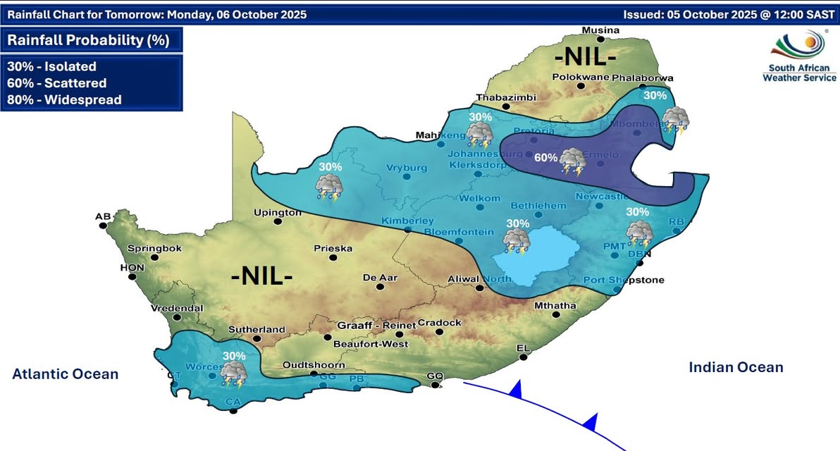
Maps for Monday 6 October
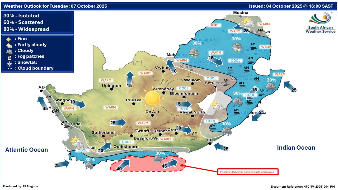
 Maps for Tuesday 7 October
|