
       Swipe left or right for more maps, and see below for others
Warnings for disruptive snowfall and rainfall as well as damaging waves on SaturdayBy Staff WriterPublished: 4 July 2025 [updated 5 July] This forecast is for: Sat 05 July 2025 The maps cover: Sat 05 Jul – Mon 07 Jul
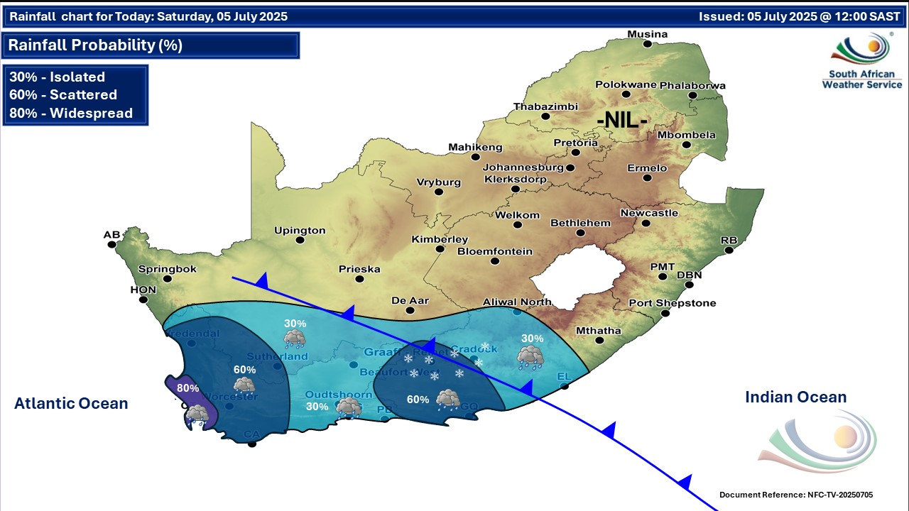
A newer forecast is available by clicking here. You can listen to this daily weather forecast as a 4 minute podcast by pressing the > play button above. The public and small stock farmers are advised that very cold, wet and windy conditions are expected over the Namakwa District in the Northern Cape and the interior of the Western Cape. The very cold conditions are also expected over the interior of Eastern Cape. ALSO READ: Cold fronts and cut-off low bringing more snow including Joburg and seven SA provinces. Warnings from the SA Weather Service for Saturday: A. level 4 warning for disruptive rainfall leading to flooding of roads and danger to life due to fast flowing streams over low-lying bridges over the western parts of the Western Cape. B. level 1 warning for disruptive snow leading to loss of livestock, passes closed and traffic disruptions due to snow and icy roads in places over the north-western parts of the Eastern Cape. C. level 2 warning for damaging waves leading to difficulty in navigation at sea between Cape Agulhas and East London. Regional forecasts from the SA Weather Service for Saturday: 1. GAUTENG Fine and cold with morning fog in the south. It will be cool in the extreme north. The expected UVB sunburn index: High 2. MPUMALANGA Morning fog and frost in the south-western Highveld, otherwise fine and cool to warm, but cold in places in the Highveld. 3. LIMPOPO Fine and cool to warm, but hot in places in the Lowveld. 4. NORTH-WEST PROVINCE Fine and cold. 5. FREE STATE Fine and cold, but partly cloudy in the south. 6. NORTHERN CAPE Fine and cool in the north, otherwise partly cloudy and cold to very cold with isolated showers. The wind along the coast will be moderate to fresh north-westerly. 7. WESTERN CAPE Cloudy and cold with isolated showers and rain, but scattered to widespread in the west. The wind along the coast will be fresh to strong north-westerly to westerly. The expected UVB sunburn index: Low 8. WESTERN HALF OF THE EASTERN CAPE Cloudy and cold to very cold, with scattered showers and rain but isolated in the north-east. Snowfalls expected in places over the northern high-lying areas from morning. The wind along the coast will be moderate to fresh north-Westerly. 9. EASTERN HALF OF THE EASTERN CAPE Partly cloudy and cool to cold, with isolated showers and rain in the west. The wind along the coast will be light to moderate westerly. 10. KWAZULU-NATAL Morning fog in the north-east, otherwise fine and cool to cold. The wind along the coast will be light to moderate northerly to north-westerly. The expected UVB sunburn index: High Travellers forecasts from the SA Weather Service for Saturday: PRETORIA Fine. Minimum/Maximum: 05/16°C The expected UVB Sunburn Index: High JOHANNESBURG Fine. Minimum/Maximum: 03/16°C VEREENIGING Fine with morning fog. Minimum/Maximum: 02/15°C MBOMBELA Fine. Minimum/Maximum: 09/23°C POLOKWANE Fine. Minimum/Maximum: 03/20°C MAHIKENG Fine Minimum/Maximum: 01/18°C VRYBURG Fine Minimum/Maximum: -1/18°C BLOEMFONTEIN Fine Minimum/Maximum: -1/14°C KIMBERLEY Fine Minimum/Maximum: -12/16°C UPINGTON Fine Minimum/Maximum: 0/19°C CAPE TOWN Cloudy with widespread showers and rain. Wind: Moderate to fresh north-westerly. Minimum/Maximum: 11/14°C The expected UVB Sunburn Index: Low GEORGE Cloudy isolated showers in the early morning. Wind: Moderate to fresh westerly to north-westerly. Minimum/Maximum: 10/17°C GQEBERHA Cloudy with scattered showers and rain. Wind: moderate north-westerly. Minimum/Maximum: 13/18°C EAST LONDON Cloudy with isolated showers at night. Wind: Light to moderate westerly. Minimum/Maximum: 14/19°C DURBAN Fine. Wind: light to moderate north-westerly. Minimum/Maximum: 13/21°C The expected UVB Sunburn Index: High RICHARDS BAY Fine. Wind: Light to moderate north-westerly. Minimum/Maximum: 13/24°C PIETERMARITZBURG Fine. Minimum/Maximum: 05/20°C This forecast is usually updated a few times per day.
Please be sure to send photos and videos to us via whatsapp and also tell us where and when they were taken. Follow our channels
Maps for Sunday 6 July
  Maps for Monday 7 July

|