
 More maps below the forecast
Weather – four warnings for Monday including disruptive snow and thunderstorms3 November 2024 [updated 4 November]By Staff Writer
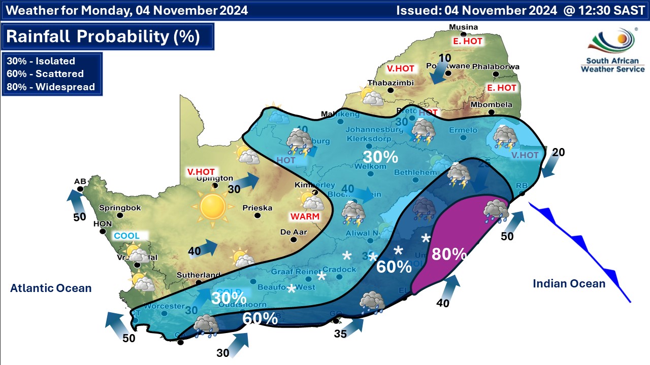
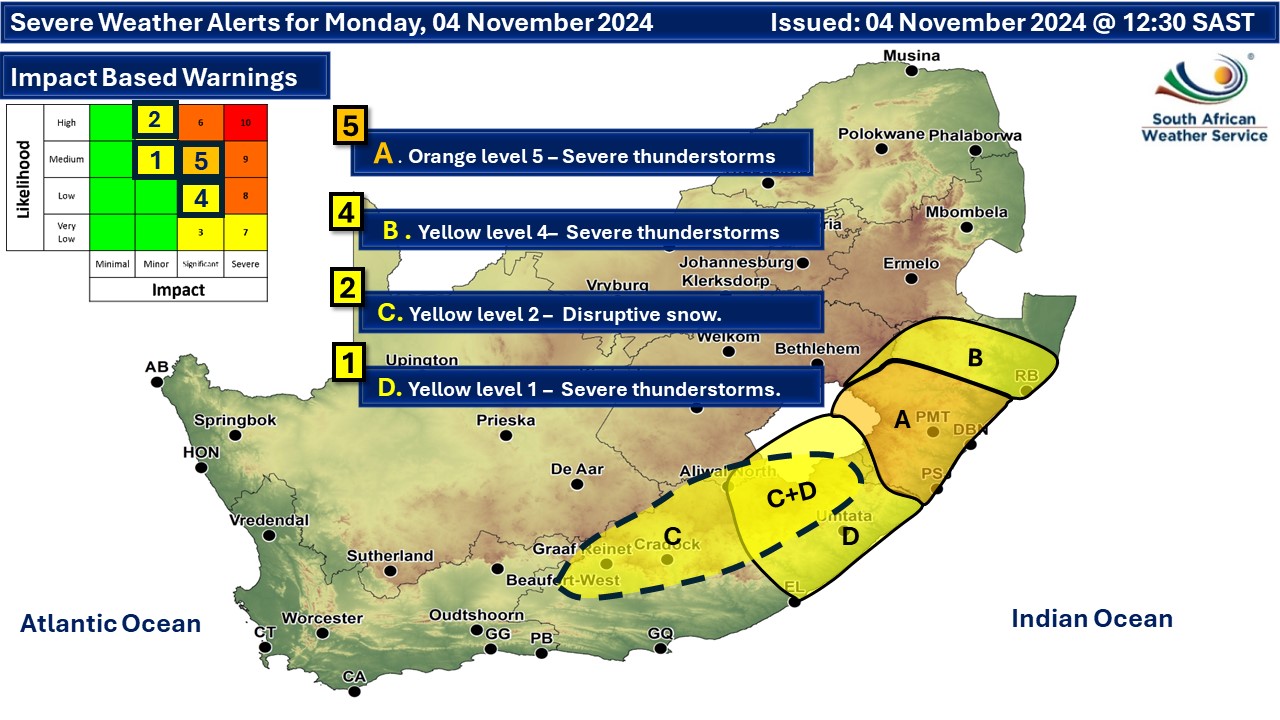
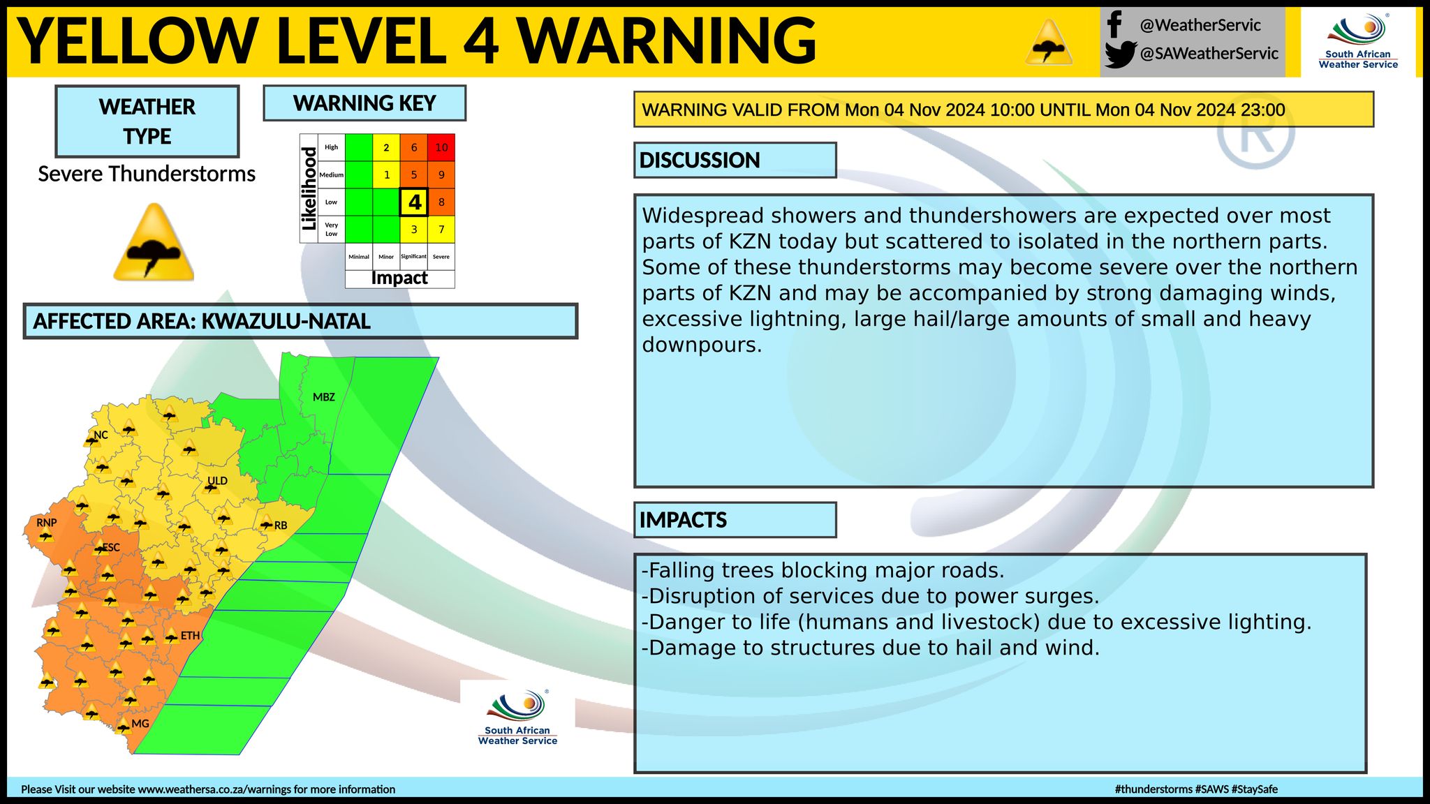
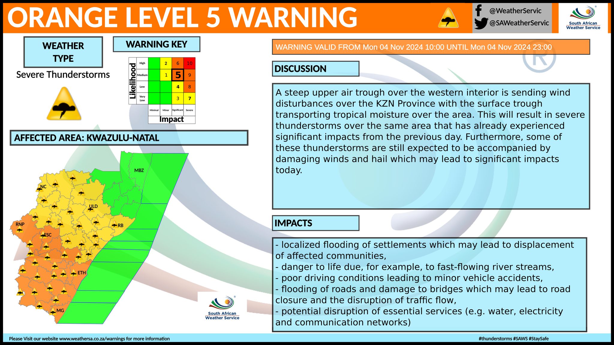
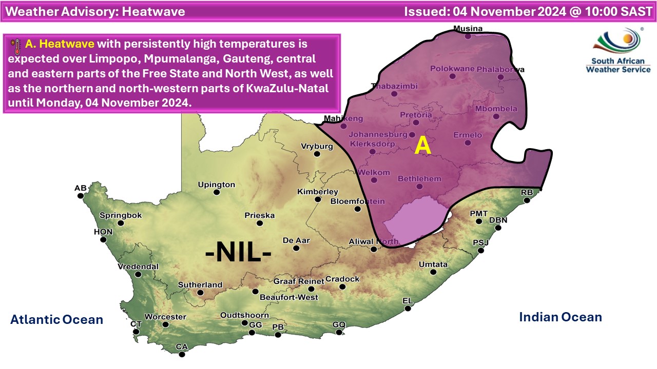
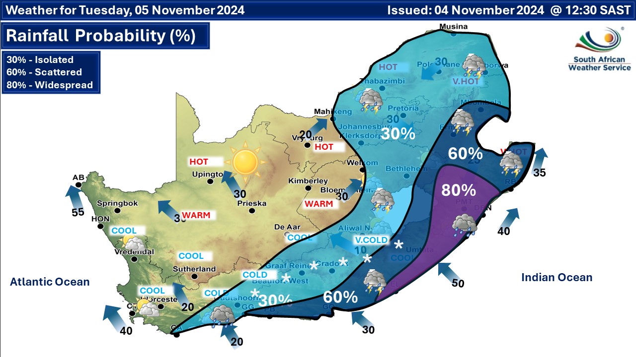
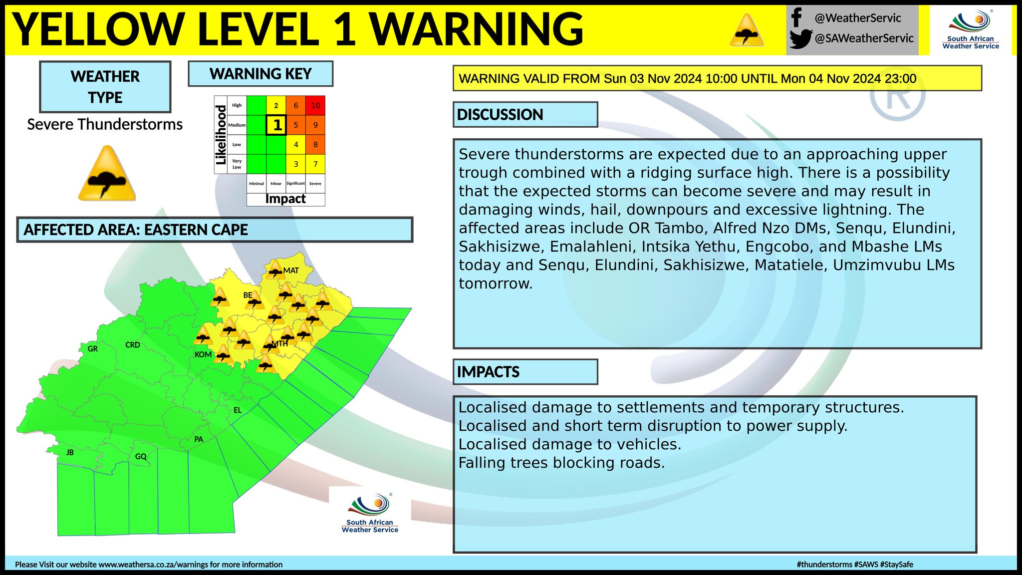
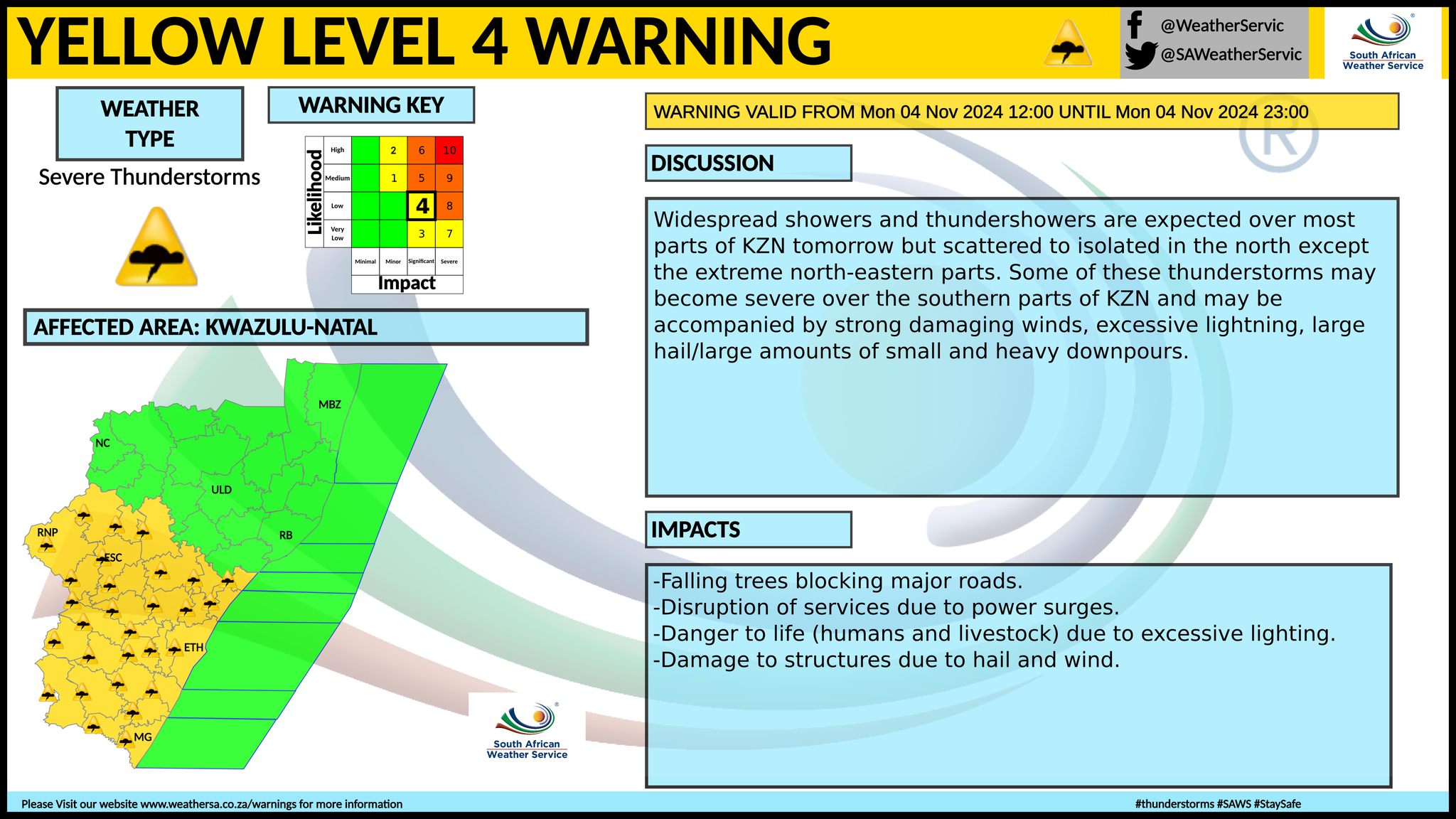
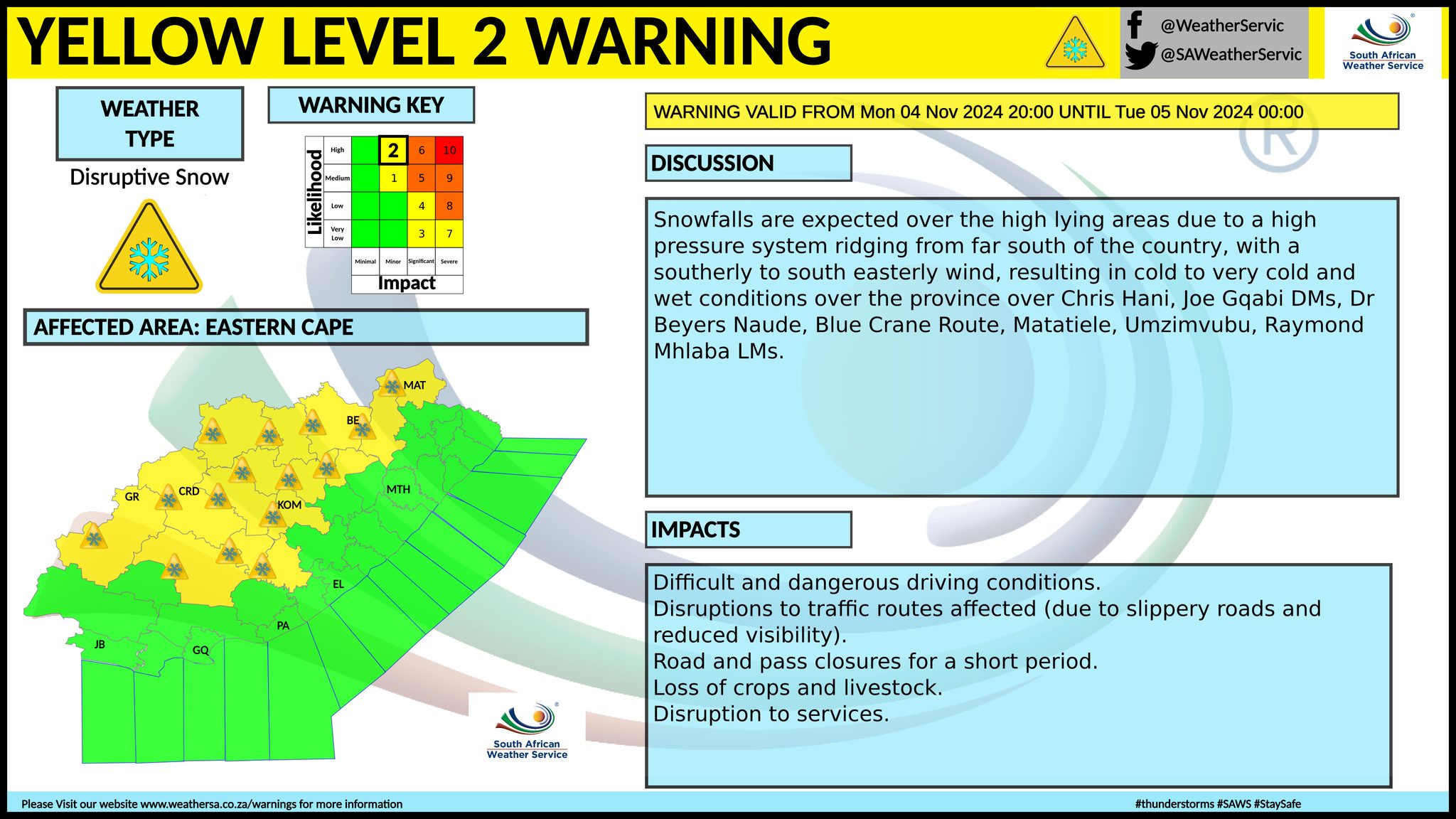
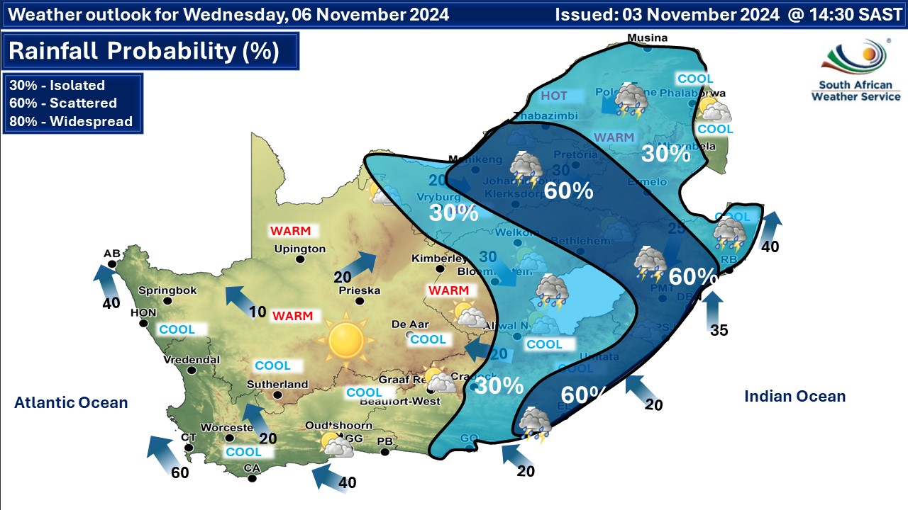
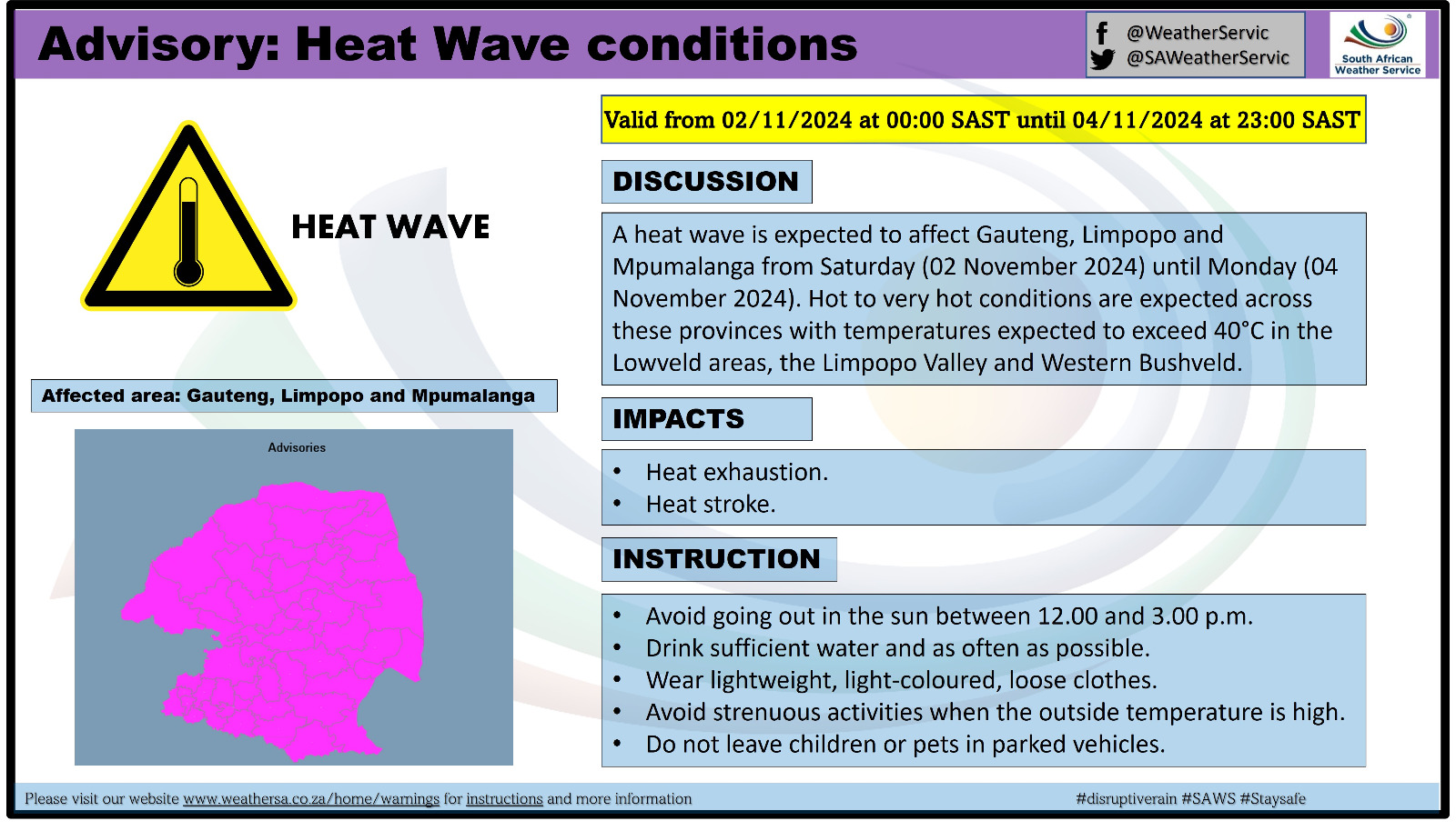
A newer forecast is available by clicking here. Isolated to scattered showers and thundershowers are expected over the central, south and south-eastern parts of South Africa but widespread along the south-east coast. Snow is expected along the Eastern Cape escarpment, according to the SA Weather Service. Isolated to scattered showers and thundershowers are expected over the central, eastern and south parts but widespread along the south-east coast on Tuesday and Wednesday. Snow is expected along the Eastern Cape escarpment only on Tuesday. A heat wave with persistently high temperatures is expected over the central and eastern parts of both North West and the Free State, northern parts of KwaZulu-Natal, Gauteng, Mpumalanga and Limpopo. We have also put out a separate snow forecast for Monday and Tuesday and will update it again shortly. ALSO READ: Snowvember! Late-season disruptive snowfall warning for Monday and Tuesday. Warnings from the SA Weather Service (SAWS) for Monday: A. orange level 5 warning for severe thunderstorms over the south-western parts of KwaZulu-Natal. B. yellow level 4 warning for severe thunderstorms over the northern parts of KwaZulu-Natal, as per the map below. C. yellow level 2 warning for disruptive snow leading to localised traffic disruptions and localised loss of livestock is expected over the northern and central high lying areas of the Eastern Cape on Monday evening into Tuesday. D. yellow level 1 warning for severe thunderstorms parts of the Eastern Cape, as per the map below. Extremely high fire danger conditions are expected over central and eastern parts of the Northern Cape, eastern parts of North West, the Free State, Gauteng, and in places of the Western Bushveld of Limpopo. Warnings from the SA Weather Service (SAWS) for Monday into Tuesday: A. yellow level 2 warning for disruptive snow as per the map below. B. yellow level 4 warning for disruptive rain leading to flooding of settlements, roads, damage to property is expected over the eastern parts of the Eastern Cape on Tuesday. C. yellow level 1 warning for disruptive rain leading to flooding of settlements, roads, damage to property is expected in places along the along the coast and adjacent interior on Tuesday over the Eastern Cape. D. yellow level 2 warning for severe thunderstorms as per the map below. E. yellow level 2 warning for damaging winds as per the map below. Regional forecasts from SAWS for Monday: 1. GAUTENG Fine in the morning, otherwise partly cloudy and hot to very hot but extremely hot. The expected UVB sunburn index: Extreme 2. MPUMALANGA Fine and warm to hot, but extremely hot in places in the lowveld, becoming partly cloudy with isolated showers and thundershowers in the south. 3. LIMPOPO Fine very hot, but extremely hot in places. 4. NORTH WEST Partly cloudy, windy and hot to very hot, with isolated showers and thundershowers in the west. 5. FREE STATE Partly cloudy, windy and warm to hot, with isolated showers and thundershowers, except the extreme west. 6. NORTHERN CAPE Partly cloudy, windy and warm to hot, with isolated showers and thundershowers in the extreme north-east and extreme south-east. It will be cool along the coast with moderate to fresh southerly to south-easterly wind. 7. WESTERN CAPE Cloudy and cool to cold with isolated showers and rain over the central and eastern parts but scattered along the south coast becoming partly cloudy in the west from the afternoon. Light snowfalls is possible over the Nuweveld mountains from evening. The wind along the coast will be fresh to strong south-westerly along the south coast, otherwise southerly to south-easterly. The expected UVB sunburn index: Very High 8. WESTERN HALF OF THE EASTERN CAPE Cloudy and cool with scattered showers and rain, but with isolated thundershowers in the north. Snowfall can be expected over the northern parts in the evening. The wind along the coast will be fresh to strong south-westerly. 9. EASTERN HALF OF THE EASTERN CAPE Cloudy and cold to cool with scattered to widespread showers and thundershowers, but isolated in the north. Snowfall can be expected over the northern parts in the evening. The wind along the coast will be moderate to fresh south-westerly. 10. KWAZULU-NATAL Morning fog patches over the extreme southern parts, otherwise partly cloudy and warm to hot but very hot in places in the north. Isolated showers and thundershowers are expected except in the extreme north-east, but scattered in the south. The wind along the coast will be light to moderate northerly to north-westerly in the morning, otherwise moderate to fresh north-easterly but south-westerly in the south spreading northwards from afternoon reaching strong in places. The expected UVB sunburn index: Low Travellers forecasts from SAWS for Monday: PRETORIA Fine in the morning, otherwise partly cloudy. Minimum/Maximum: 20/36°C The expected UVB Sunburn Index: Extreme JOHANNESBURG Fine in the morning, otherwise partly cloudy. Minimum/Maximum: 16/34°C VEREENIGING Fine in the morning, otherwise partly cloudy. Minimum/Maximum: 19/36°C MBOMBELA Fine, becoming partly cloudy. Minimum/Maximum: 19/34°C POLOKWANE Fine. Minimum/Maximum: 17/35°C MAHIKENG Partly cloudy, and windy Minimum/Maximum: 21/36°C VRYBURG Partly cloudy, and windy, with isolated showers and thundershowers. Minimum/Maximum: 18/36°C BLOEMFONTEIN Partly cloudy, and windy, with isolated showers and thundershowers. Minimum/Maximum: 18/33°C KIMBERLEY Partly cloudy, and windy, with isolated showers and thundershowers. Minimum/Maximum: 17/33°C UPINGTON Fine and windy. Minimum/Maximum: 14/27°C CAPE TOWN Cloudy with morning showers becoming partly cloudy in the afternoon. Wind: Moderate to fresh south-westerly to southerly, becoming south-easterly in the afternoon. Minimum/Maximum: 12/16°C The expected UVB Sunburn Index: Very High GEORGE Cloudy with scattered showers and rain. Wind: Moderate to fresh south-westerly to southerly. Minimum/Maximum: 11/17°C GQEBERHA Cloudy with scattered showers and rain. Wind: Fresh to strong south-westerly. Minimum/Maximum: 13/19°C EAST LONDON Partly cloudy to cloudy with widespread thunderstorms. Wind: Moderate to fresh south-westerly. Minimum/Maximum: 14/18°C DURBAN Cloudy with widespread showers and thundershowers. Wind: Moderate northerly to north-westerly in the morning, otherwise moderate to fresh south-westerly reaching strong at times. Minimum/Maximum: 18/23°C The expected UVB Sunburn Index: Low RICHARDS BAY Partly cloudy becoming cloudy in the afternoon with scattered showers and thundershowers. Wind: Moderate northerly to north-westerly in the morning, otherwise moderate to fresh north-easterly becoming south-westerly by the afternoon reaching strong at times. Minimum/Maximum: 20/27°C PIETERMARITZBURG Cloudy with widespread showers and thundershowers. Minimum/Maximum: 14/23°C This forecast may change and updates issued more than once a day. Please be sure to send photos and videos to us via whatsapp and also tell us where and when they were taken. See below for a link to our whatsapp channel but since the link does not work in the instagram app you will need to send us a whatsapp message and we'll send you a link. Follow our channels
Standard users are welcome to use the standard sharing buttons on this page to share our content. It is NOT acceptable to download or screen grab for reposting. Other media and channels need to send us a request in order to embed or use of our forecasts, maps, as well as images and video from our users that we post (before doing so).
Issued on Monday
       Issued on Sunday
    Issued on Friday
 |