


SUNDAY WEATHER: Widespread rainfall and a LEVEL 5 thunderstorm warning for five provinces
By Staff WriterPublished: 3 January 2026 [updated 4 January]
This forecast is for: Sun 04 January 2026
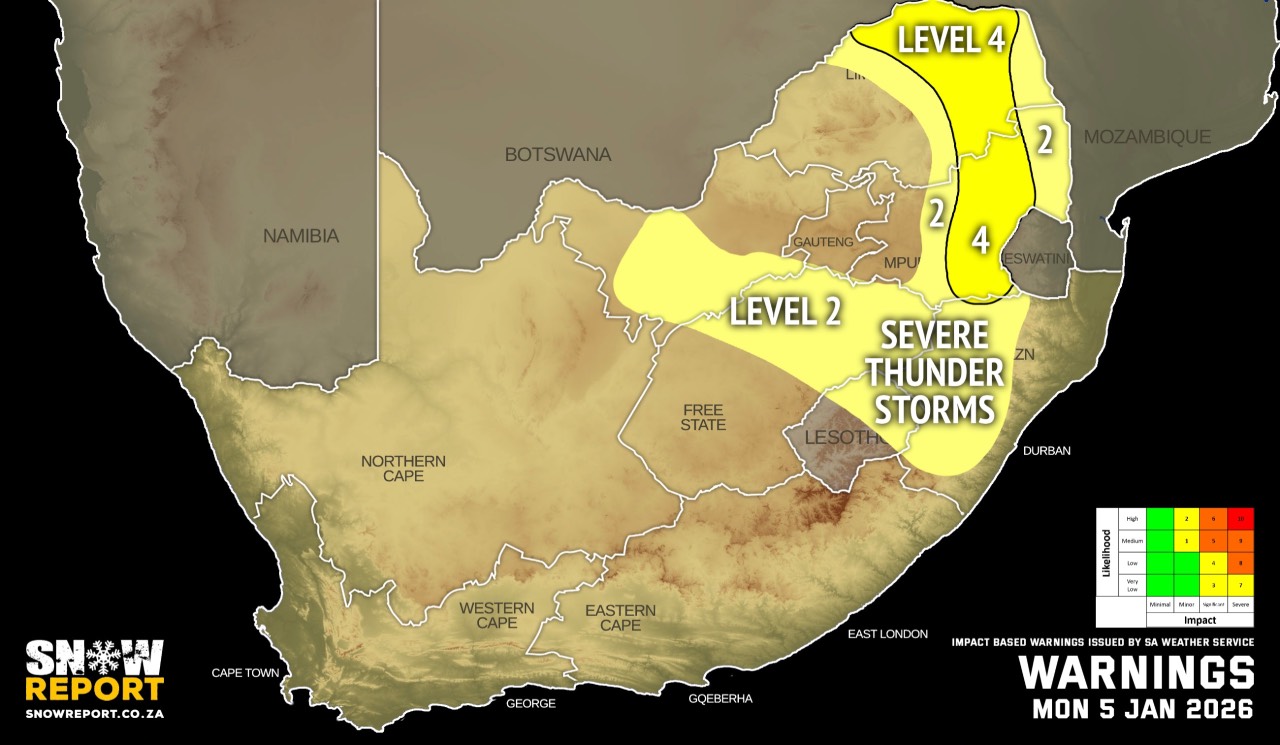
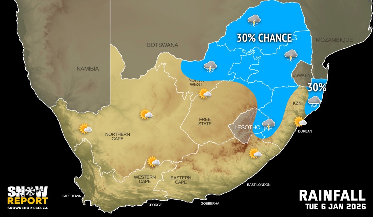
The maps cover: Sun 04 Jan – Tue 06 Jan
| SHARE TO |
The latest forecast is available by clicking here.
From Sunday it should be partly cloudy and cool over the central and eastern parts of the country with isolated to scattered showers and thundershowers possible, but widespread in places.
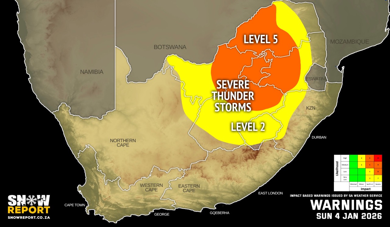
Warnings from the SA Weather Service for Sunday:
A. level 5 warning for severe thunderstorms leading to flooding of susceptible roads, settlements, low-lying bridges/areas and damage to infrastructure due to heavy downpours and strong damaging winds over the eastern parts of the Free State, eastern parts of the North West, Gauteng, western parts of Limpopo as well as the Highveld of Mpumalanga.
B. level 2 warning for severe thunderstorms leading to localized flooding of susceptible roads, settlements, low-lying bridges/areas and localized damage to infrastructure due to heavy downpours and strong damaging winds over the extreme north-eastern parts of the Northern Cape, western parts of both the Free State and North West, the western parts of KwaZulu-Natal as well as along the escarpment of both Mpumalanga and Limpopo.
Extremely high fire danger conditions are expected over the Dawid Kruiper and Kai Garib municipalities of the Northern Cape as well as the West Coast district of the Western Cape.
Regional forecasts from the SA Weather Service for Sunday:
GAUTENG
Cloudy and warm with widespread showers and thundershowers.
MPUMALANGA
Cloudy and cool to warm with scattered to widespread showers and thundershowers, but isolated in the Lowveld.
LIMPOPO
Morning fog patches along the escarpment, otherwise cloudy and warm to hot with isolated to scattered showers and thundershowers, but widespread in the south-west.
NORTH WEST
Fog patches in the east at first, otherwise cloudy, windy and warm to hot, with widespread showers and thundershowers, but scattered in the extreme west.
THE FREE STATE
Fog patches in the east at first, otherwise cloudy, windy and cool to warm, with widespread showers and thundershowers, but isolated to scattered in the west.
THE NORTHERN CAPE
Morning fog along the coast, otherwise partly cloudy, windy and warm to hot, with isolated showers and thundershowers, but scattered in the extreme east where it will be cloudy. It will be very hot in the extreme north. The wind along the coast will be moderate to fresh southerly to south-easterly.
THE WESTERN CAPE
Fine in the west, otherwise partly cloudy and warm to hot but cloudy and cool along the south coast with isolated morning showers and rain. It will be very hot in places in the west. The wind along the coast will be moderate to fresh southerly to south-easterly but strong along the south-west and west coast.
THE WESTERN HALF OF THE EASTERN CAPE
Cloudy with morning showers along the coast and adjacent interior, otherwise partly cloudy and warm with isolated thundershowers in places over the interior by late afternoon. The wind along the coast will be light south-westerly, becoming south-easterly in the afternoon.
THE EASTERN HALF OF THE EASTERN CAPE
Cloudy with morning fog south of the escarpment, otherwise partly cloudy and warm but cool in the east with isolated showers and thundershowers but scattered in the north-east. The wind along the coast will be light and variable.
KWAZULU-NATAL
Morning fog patches in places over the interior, otherwise partly cloudy and cool to warm with isolated showers and thundershowers but scattered in the west. The wind along the coast will be moderate southerly to south-westerly in the morning, otherwise moderate easterly to south-easterly becoming light north-easterly in the south in the evening.
Travellers forecasts from the SA Weather Service for Sunday:
PRETORIA
Cloudy with widespread showers and thundershowers.
Minimum/Maximum: 14/26°C
JOHANNESBURG
Cloudy with widespread showers and thundershowers.
Minimum/Maximum: 15/26°C
VEREENIGING
Cloudy with widespread showers and thundershowers.
Minimum/Maximum: 13/27°C
MBOMBELA
Cloudy with scattered showers and thundershowers.
Minimum/Maximum: 17/23°C
POLOKWANE
Cloudy with scattered showers and thundershowers.
Minimum/Maximum: 17/23°C
MAHIKENG
Cloudy and windy, with widespread showers and thundershowers.
Minimum/Maximum: 18/28°C
VRYBURG
Cloudy and windy, with scattered showers and thundershowers.
Minimum/Maximum: 19/30°C
BLOEMFONTEIN
Cloudy and windy, with scattered showers and thundershowers.
Minimum/Maximum: 16/26°C
KIMBERLEY
Cloudy and windy, with scattered showers and thundershowers.
Minimum/Maximum: 19/30°C
UPINGTON
Partly cloudy and windy, with isolated showers and thundershowers.
Minimum/Maximum: 21/38°C
CAPE TOWN
Fine.
Wind: Moderate to fresh southerly to south-easterly becoming strong in the afternoon.
Minimum/Maximum: 21/29°C
GEORGE
Cloudy with isolated morning showers and rain.
Wind: Moderate south-easterly.
Minimum/Maximum: 17/23°C
GQEBERHA
Cloudy with isolated morning showers, otherwise partly cloudy.
Wind: Light south-westerly, becoming south-easterly in the afternoon.
Minimum/Maximum: 18/25°C
EAST LONDON
Cloudy with isolated morning showers.
Wind: Light and variable.
Minimum/Maximum: 18/25°C
DURBAN
Partly cloudy with isolated showers and thundershowers.
Wind: Moderate southerly to south-westerly in the morning, otherwise moderate easterly to south-easterly becoming light north-easterly in the evening.
Minimum/Maximum: 19/25°C
RICHARDS BAY
Partly cloudy with isolated showers and thundershowers.
Wind: Moderate southerly to south-westerly, becoming moderate easterly to south-easterly in the afternoon.
Minimum/Maximum: 19/27°C
PIETERMARITZBURG
Morning fog, otherwise partly cloudy with isolated showers and thundershowers.
Minimum/Maximum: 12/23°C
This forecast is usually updated a few times per day.
| SHARE TO |
Please be sure to send photos and videos to us via whatsapp and also tell us where and when they were taken.
Follow our channels