
          Swipe left or right for more maps
Severe thunderstorm warnings with heavy rain and hail in the central part of SA on FridayBy Staff WriterPublished: 30 October 2025 [updated 31 October] This forecast is for: Fri 31 October 2025 The maps cover: Fri 31 Oct – Sun 02 Nov
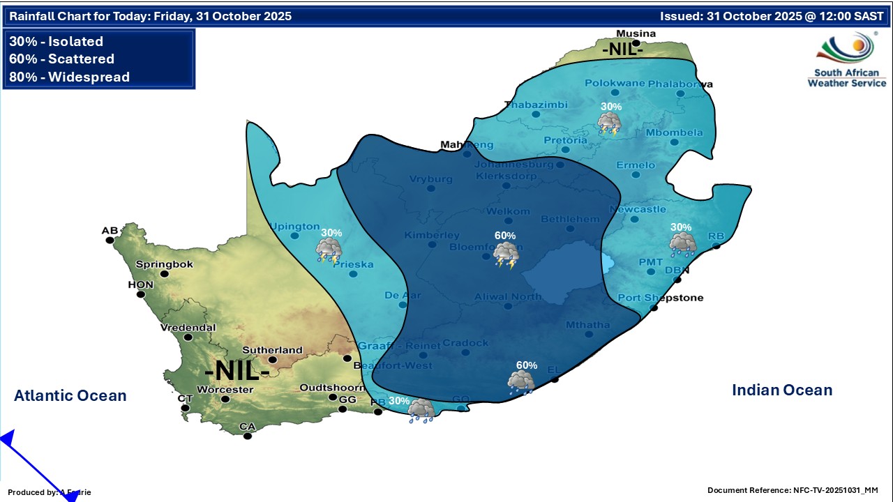
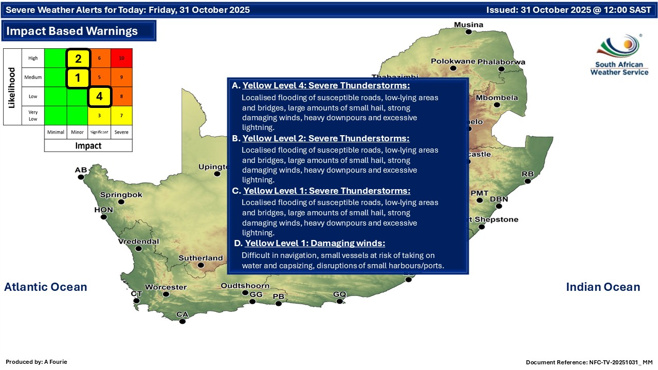
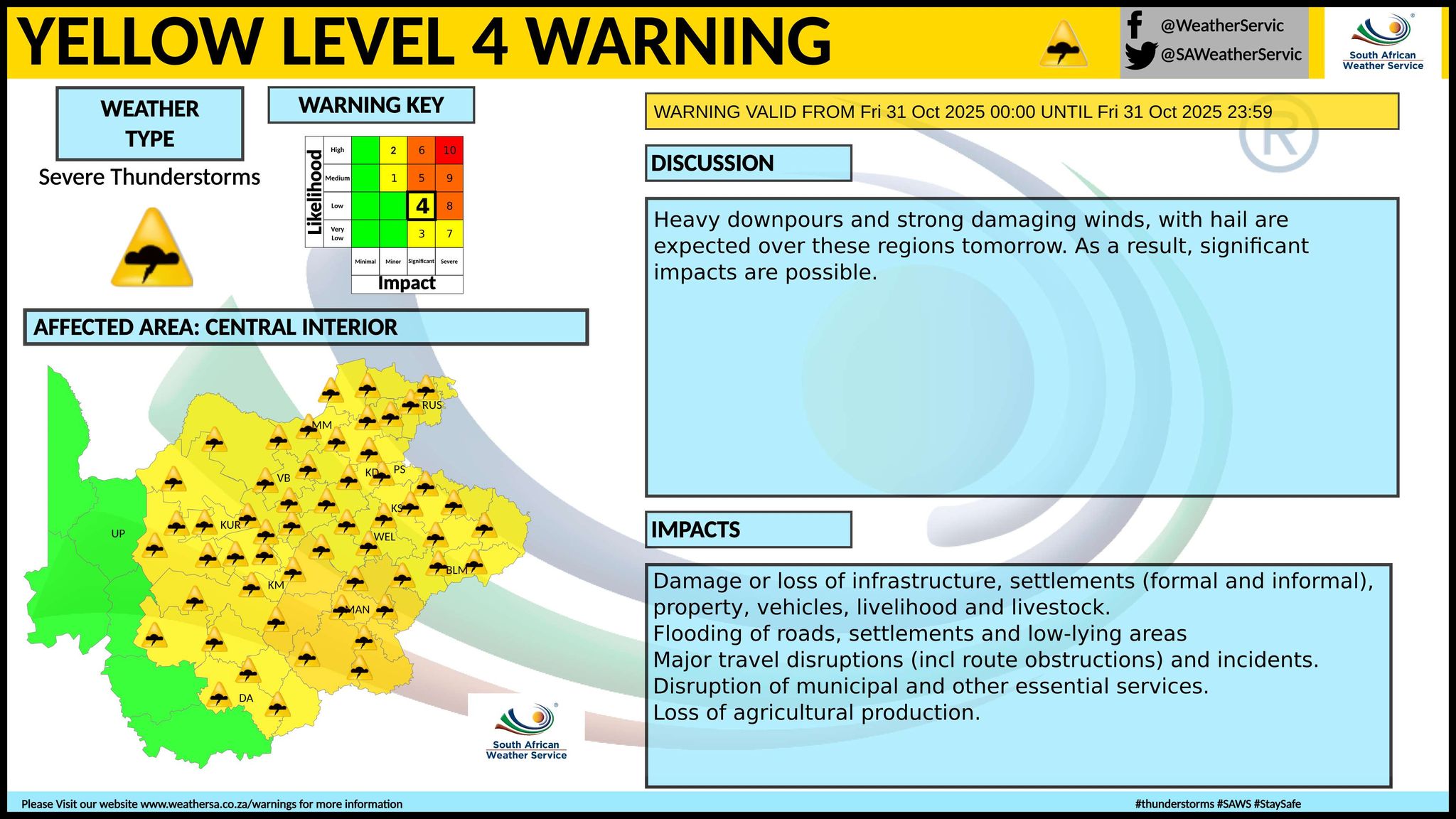
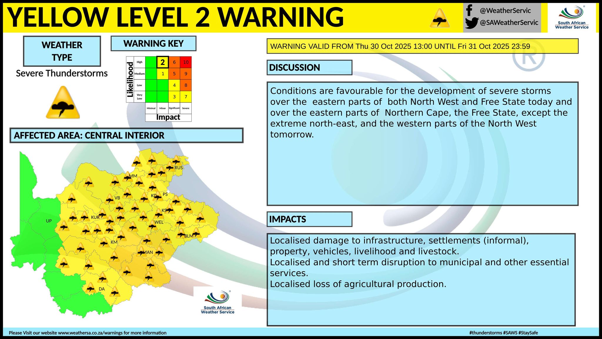
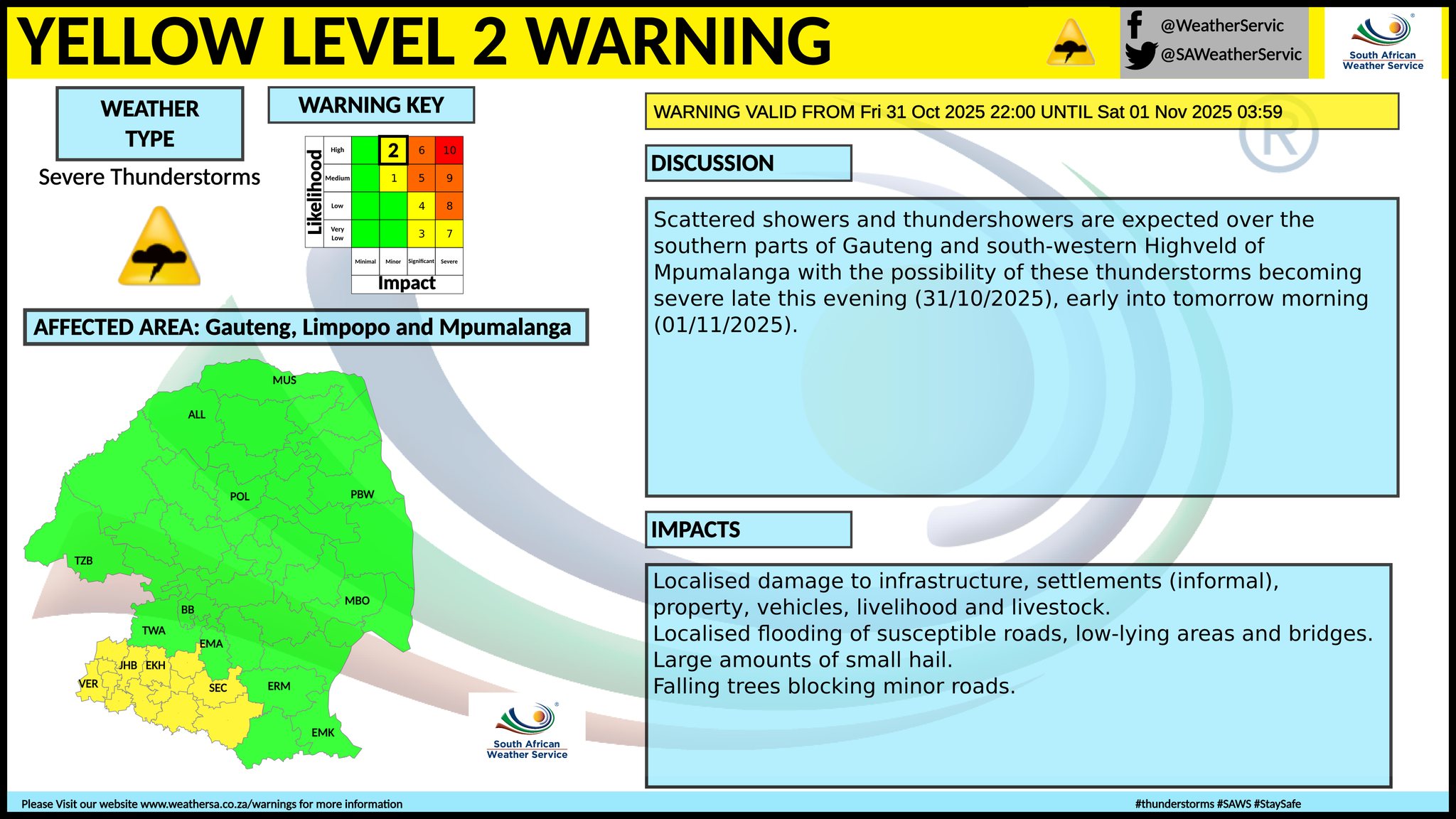
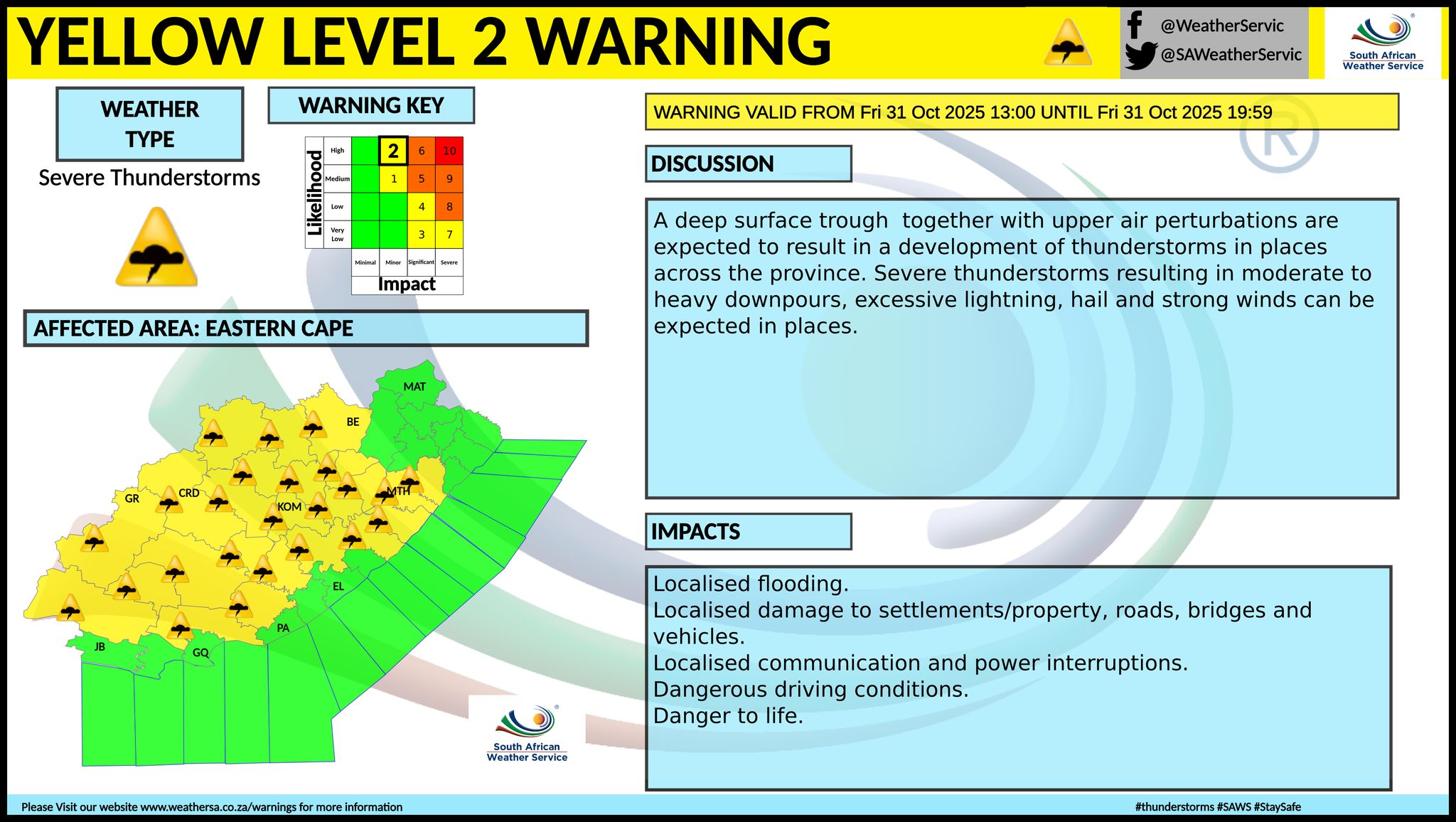
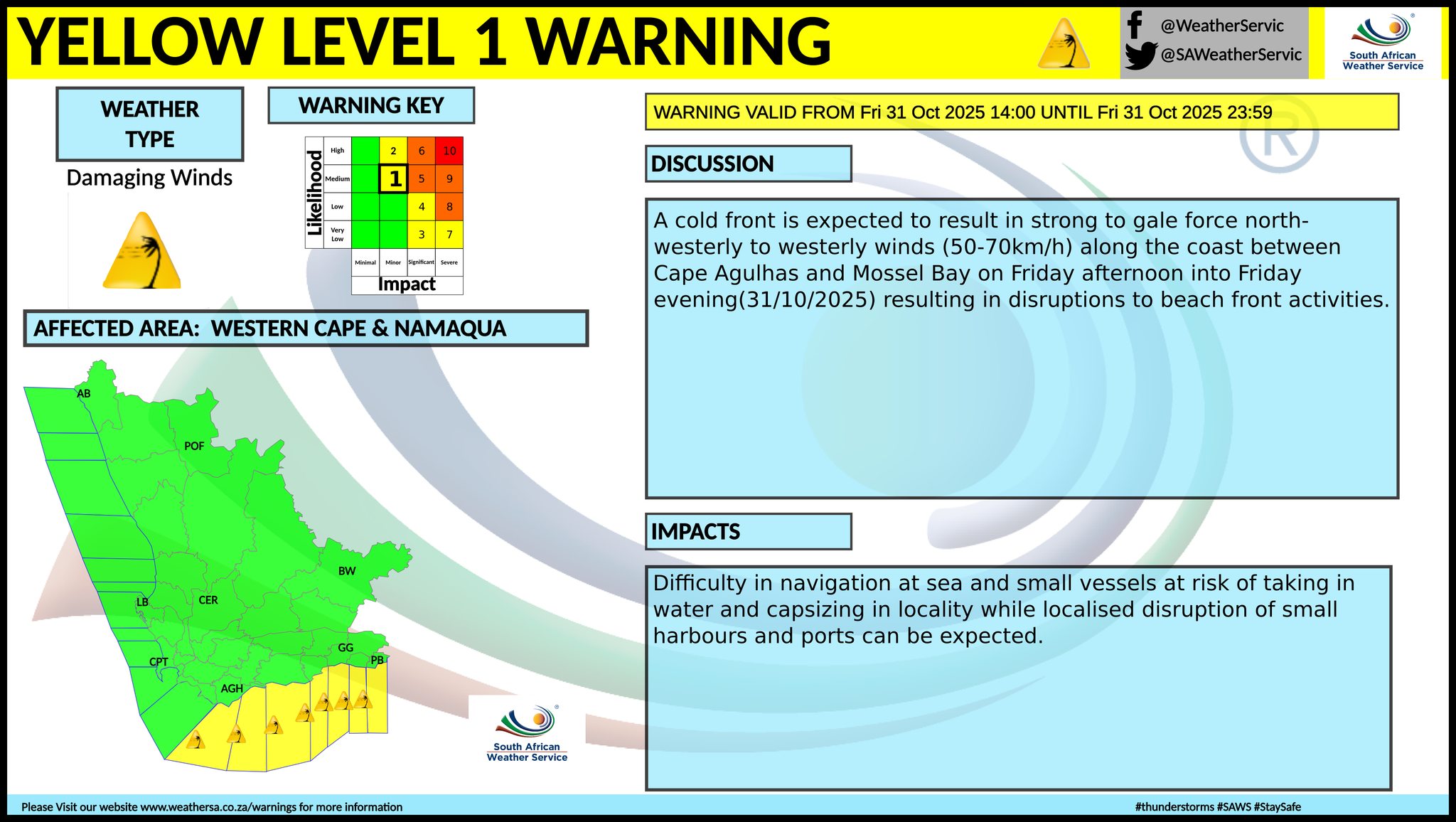
The latest forecast is available by clicking here. From Saturday it should be fine over the western interior, otherwise partly cloudy and warm to hot with isolated to scattered showers and thundershowers in the east and north-east parts, but light and showers along the south and south-west coast where it will be cool. Fog can be expected in parts of the Western Cape and KwaZulu-Natal. Warnings from the SA Weather Service for Friday: A. level 4 warning for severe thunderstorms leading to flooding of susceptible roads, low-lying areas and bridges, large amounts of small hail, strong damaging winds, heavy downpours and excessive lightning for the central and western parts of the Free State. B. level 2 warning for severe thunderstorms leading to localised flooding of susceptible roads, low-lying areas and bridges, large amounts of small hail, strong damaging winds, heavy downpours and excessive lightning issued for North West, the central and southern parts of Gauteng, the eastern parts of Northern Cape and the Free State as well as the Eastern Cape excluding the extreme eastern parts. C. level 1 warning for severe thunderstorms leading to localised flooding of susceptible roads, low-lying areas and bridges, large amounts of small hail, strong damaging winds, heavy downpours and excessive lightning for the southern parts of KwaZulu-Natal. level 1 warning for damaging winds. A cold front is expected to result in strong to gale force north-westerly to westerly winds (50-70km/h) along the coast between Cape Agulhas and Mossel Bay on Friday afternoon into Friday evening resulting in disruptions to beach front activities. Extremely high fire danger conditions are expected over the central and western parts of Eastern Cape and the central and eastern parts of Northern Cape and Western Cape. Regional forecasts from the SA Weather Service for Friday: GAUTENG Partly cloudy and cool to warm with isolated showers and thundershowers but scattered in the south. The expected UVB sunburn index: Low MPUMALANGA Cloudy and cool to warm with isolated showers and thundershowers, but scattered in the south-west. LIMPOPO Cloudy and warm to hot with isolated showers and thundershowers, except in the north-west. NORTH-WEST Cloudy, windy and warm with scattered showers and thundershowers, but isolated in the east. THE FREE STATE Cloudy, windy and cool to warm, with scattered showers and thundershowers. THE NORTHERN CAPE Fine in places in the west, otherwise partly cloudy, windy and warm to hot with isolated showers and thundershowers but scattered in the extreme east. The wind along the coast will be moderate south-westerly. THE WESTERN CAPE Fog patches along the coast in the morning and evening, otherwise partly cloudy and cool to warm, but hot over the eastern interior. The wind along the coast will be moderate to fresh westerly to south-westerly, but strong at times along the south coast. The expected UVB sunburn index: Very High THE WESTERN HALF OF THE EASTERN CAPE Partly cloudy and hot to very hot with scattered showers and thundershowers but isolated along the coast where it will be warm. The wind along the coast will be Light to moderate northerly at first, otherwise fresh to strong south-westerly. THE EASTERN HALF OF THE EASTERN CAPE Very hot in places, otherwise partly cloudy and warm to hot with scattered showers and thundershowers. The wind along the coast will be light to moderate north-easterly, becoming moderate to fresh south-westerly from the south in the evening KWAZULU-NATAL Morning fog patches over the interior, otherwise partly cloudy and cool to warm with isolated showers and thundershowers but scattered int the extreme south. The wind along the coast will be moderate to fresh easterly to south-easterly, becoming north-easterly in the south from the afternoon. The expected UVB sunburn index: Very High Travellers forecasts from the SA Weather Service for Friday: PRETORIA Partly cloudy with isolated showers and thundershowers. Minimum/Maximum: 15/24°C The expected UVB Sunburn Index: Low JOHANNESBURG Partly cloudy with scattered showers and thundershowers. Minimum/Maximum: 13/22°C VEREENIGING Partly cloudy with scattered showers and thundershowers. Minimum/Maximum: 15/24°C MBOMBELA Cloudy with isolated showers and thundershowers. Minimum/Maximum: 18/20°C POLOKWANE Cloudy with isolated showers and thundershowers. Minimum/Maximum: 18/25°C MAHIKENG Cloudy and windy, with scattered showers and thundershowers. Minimum/Maximum: 16/26°C VRYBURG Cloudy and windy, with scattered showers and thundershowers. Minimum/Maximum: 16/29°C BLOEMFONTEIN Cloudy and windy, with scattered showers and thundershowers. Minimum/Maximum: 15/23°C KIMBERLEY Cloudy and windy, with scattered showers and thundershowers. Minimum/Maximum: 17/27°C UPINGTON Partly cloudy and windy, with isolated showers and thundershowers. Minimum/Maximum: 21/34°C CAPE TOWN Fog patches in the morning and evening, otherwise partly cloudy. Wind: Moderate to fresh westerly to north-westerly. Minimum/Maximum: 16/22°C The expected UVB Sunburn Index: Very High GEORGE Partly cloudy. Wind: Moderate to fresh south-westerly. Minimum/Maximum: 15/23°C GQEBERHA Partly cloudy with light showers and rain in the afternoon. Wind: Light to moderate north-westerly, becoming fresh to strong south-westerly late morning. Minimum/Maximum: 14/32°C EAST LONDON Partly cloudy with scattered showers and thundershowers In the afternoon. Wind: Moderate north-easterly, becoming fresh south-westerly in the afternoon. Minimum/Maximum: 16/33°C DURBAN Partly cloudy with isolated showers and thundershowers. Wind: Moderate to fresh north-easterly. Minimum/Maximum: 19/27°C The expected UVB Sunburn Index: Very High RICHARDS BAY Partly cloudy with isolated showers and thundershowers. Wind: Moderate to fresh northerly to north-easterly. Minimum/Maximum: 18/29°C PIETERMARITZBURG Partly cloudy with isolated showers and thundershowers. Minimum/Maximum: 15/29°C This forecast is usually updated a few times per day.
Please be sure to send photos and videos to us via whatsapp and also tell us where and when they were taken. Follow our channels
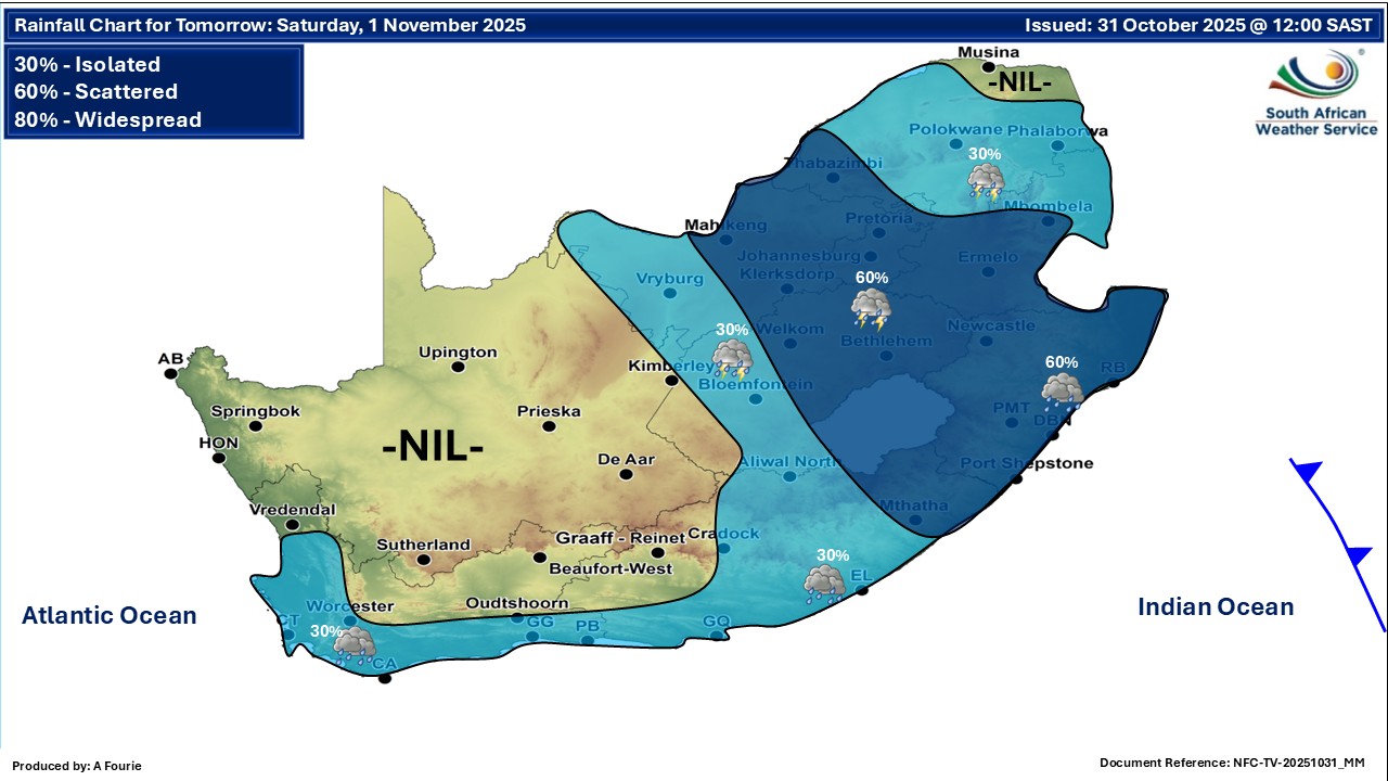
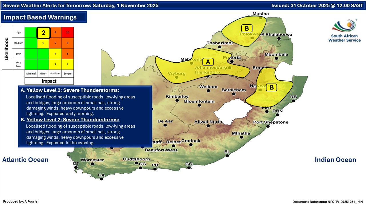
Maps for Saturday 1 November
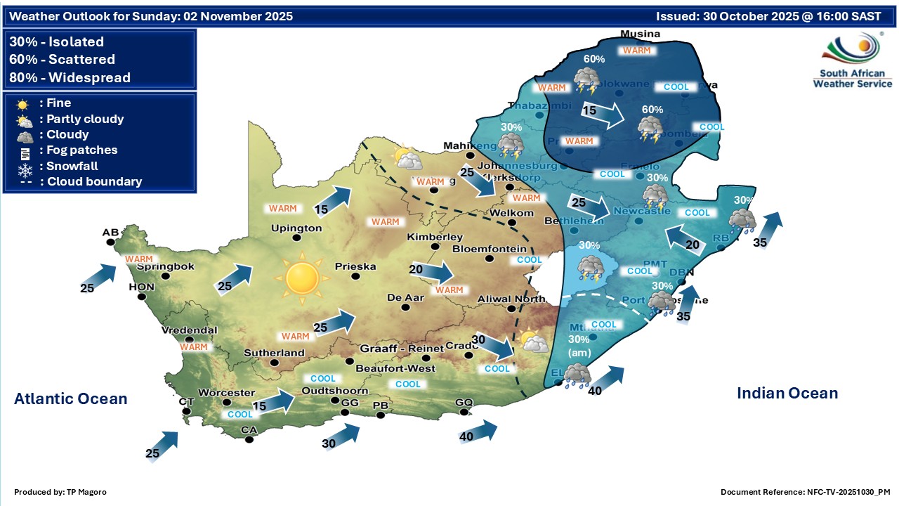
  Maps for Sunday 2 November

|