
   Swipe left or right for more maps, and see below for others
Thunderstorm warnings across four provinces on MondayBy Staff WriterPublished: 30 March 2025 [updated 31 March] This forecast is for: Mon 31 March 2025 The maps cover: Mon 31 Mar – Wed 02 Apr
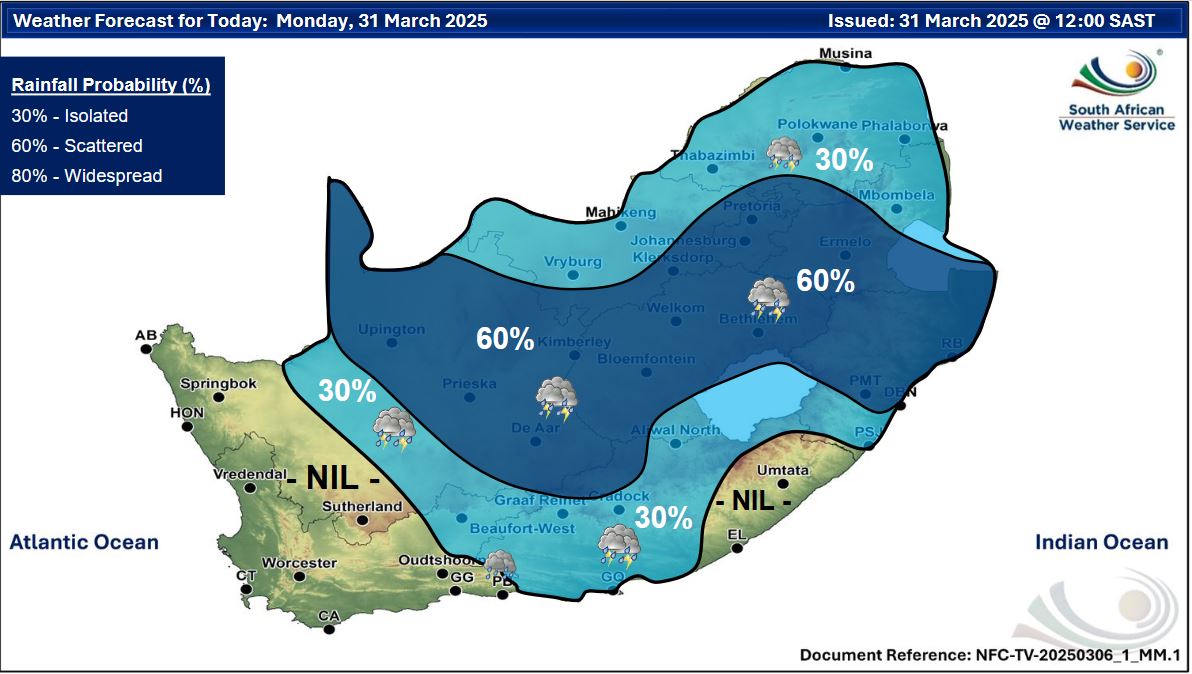
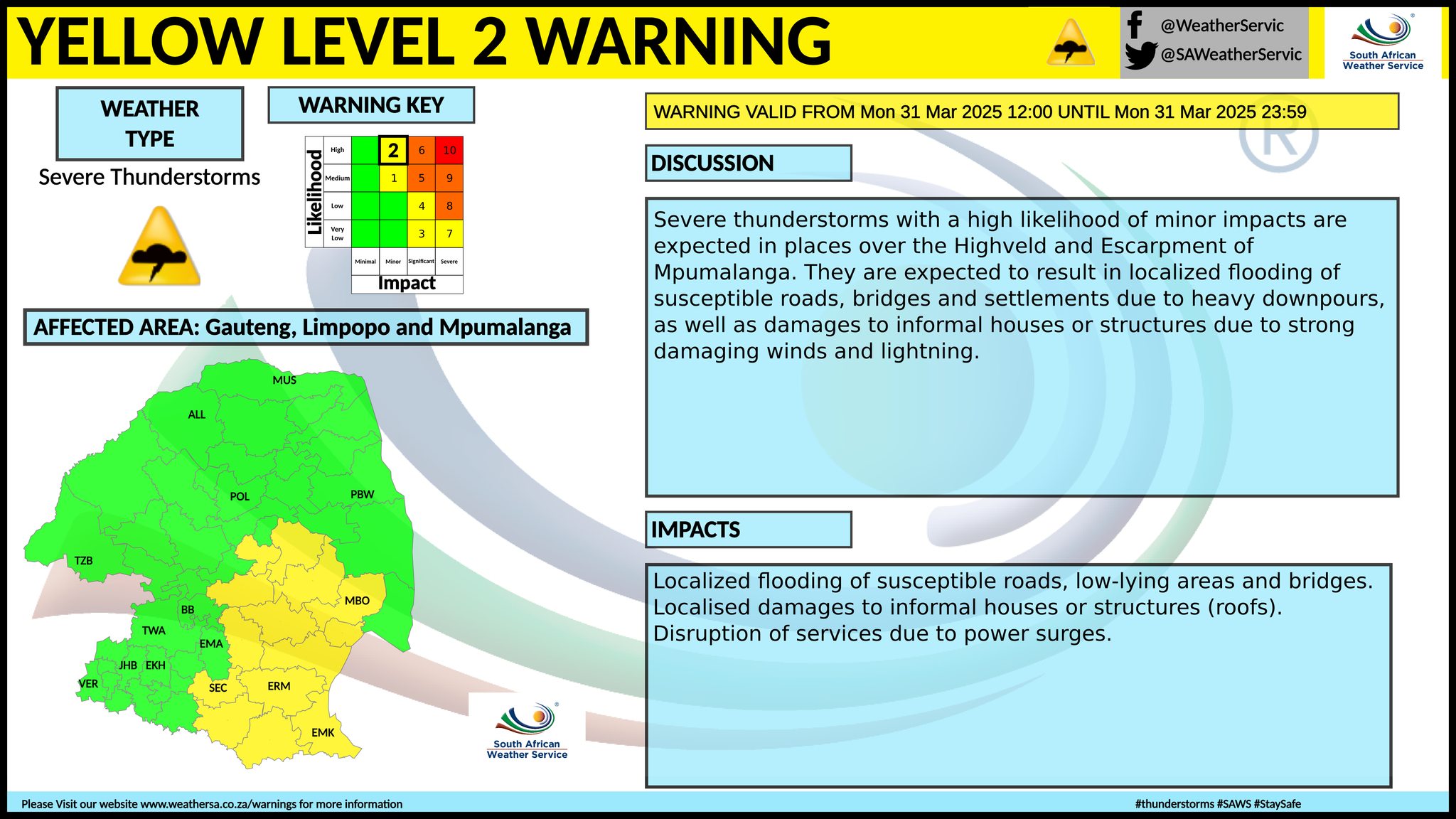
A newer forecast is available by clicking here. Isolated to scattered shows over quite a lot of the country, but not in the west according to the SA Weather Service. Warnings from the SA Weather Service for Monday: A. yellow level 2 warning severe thunderstorms resulting in damaging winds, excessive lightning, hail and heavy downpours leading to localised flooding are expected over the extreme north-eastern parts of KwaZulu-Natal in the morning. The map has now been updated to include the Highveld and escarpment of Mpumalanga, as well as parts of the Northern Cape and Free State. Extremely high fire danger conditions are expected in places in the central parts of Northern Cape. Regional forecasts from SAWS for Monday: 1. GAUTENG Partly cloudy and cool, becoming cloudy with scattered showers and thundershowers. The expected UVB sunburn index: High 2. MPUMALANGA Cloudy in the east with morning fog along the escarpment, otherwise partly cloudy and cool to warm with isolated to scattered showers and thundershowers. 3. LIMPOPO Cloudy in the east with morning fog along the escarpment, otherwise partly cloudy and warm to hot with isolated showers and thundershowers, except over the Lowveld. 4. NORTH WEST Partly cloudy and warm, with isolated showers and thundershowers but scattered over the eastern and the southern parts. 5. FREE STATE Cloudy with morning fog patches over the east at first, otherwise partly cloudy and warm, with scattered showers and thundershowers. 6. NORTHERN CAPE Fog in places in the extreme west where it will be cloudy, otherwise partly cloudy, windy and warm to hot, but cool along the coast and adjacent interior, with isolated to scattered showers and thundershowers in the central and eastern parts from the afternoon. The wind along the coast will be strong southerly to south-easterly. 7. WESTERN CAPE Misty in places over the eastern interior in the morning, otherwise partly cloudy and cool to warm, but cloudy along the coast with light rain along the south and south-west coast. Isolated showers and thundershowers can be expected over the east and northeastern interior from late afternoon. It will be windy in places over the west and southwestern coastal areas mainly in the afternoon. The wind along the coast will be strong southerly to south-easterly but moderate to fresh easterly to south-easterly in the south. The expected UVB sunburn index: High 8. WESTERN HALF OF THE EASTERN CAPE Cloudy with isolated showers and rain along the coast and adjacent interior in the morning, otherwise partly cloudy and warm with isolated thundershowers in the afternoon. The wind along the coast will be moderate easterly, but south-easterly in places. 9. EASTERN HALF OF THE EASTERN CAPE Cloudy with isolated showers and rain south-westerly in the morning, otherwise fine and warm, becoming partly cloudy with isolated thundershowers over northern interior. The wind along the coast will be moderate north-easterly. 10. KWAZULU-NATAL Cloudy with scattered showers and thundershowers but isolated in the south. The wind along the coast will be moderate southerly to south-easterly, becoming northeasterly in the afternoon. The expected UVB sunburn index: High Travellers forecasts from SAWS for Monday: PRETORIA Partly cloudy, becoming cloudy with scattered showers and thundershowers. Minimum/Maximum: 19/26°C The expected UVB Sunburn Index: High JOHANNESBURG Partly cloudy, becoming cloudy with scattered showers and thundershowers. Minimum/Maximum: 16/24°C VEREENIGING Partly cloudy, becoming cloudy with scattered showers and thundershowers. Minimum/Maximum: 16/24°C MBOMBELA Partly cloudy with isolated showers and thundershowers. Minimum/Maximum: 18/27°C POLOKWANE Partly cloudy with isolated showers and thundershowers. Minimum/Maximum: 16/27°C MAHIKENG Partly cloudy with isolated showers and thundershowers. Minimum/Maximum: 18/28°C VRYBURG Partly cloudy with isolated showers and thundershowers. Minimum/Maximum: 18/29°C BLOEMFONTEIN Partly cloudy with scattered showers and thundershowers. Minimum/Maximum: 16/28°C KIMBERLEY Partly cloudy, windy with scattered showers and thundershowers. Minimum/Maximum: 17/29°C UPINGTON Partly cloudy, windy with scattered showers and thundershowers. Minimum/Maximum: 18/33°C CAPE TOWN Cloudy becoming partly cloudy. Wind: Fresh southerly becoming strong in the afternoon. Minimum/Maximum: 17/25°C The expected UVB Sunburn Index: High GEORGE Cloudy to partly cloudy with morning light rain. Wind: Light easterly at first, otherwise moderate easterly to south-easterly. Minimum/Maximum: 15/23°C GQEBERHA Cloudy with isolated showers and rain in the morning, otherwise partly cloudy. Wind: Light to moderate south-easterly. Minimum/Maximum: 17/23°C EAST LONDON Cloudy with light showers at first, otherwise partly cloudy. Wind: Light and variable in the morning, otherwise moderate to fresh north-easterly. Minimum/Maximum: 18/24°C DURBAN Cloudy with scattered showers and thundershowers. Wind: Light to moderate southerly to south-easterly, becoming easterly to northeasterly. Minimum/Maximum: 23/27°C The expected UVB Sunburn Index: High RICHARDS BAY Cloudy with scattered showers and thundershowers. Wind: Moderate to fresh north-easterly becoming southerly to south-westerly by the evening. Minimum/Maximum: 21/30°C PIETERMARITZBURG Morning fog patches, otherwise cloudy with scattered showers and thundershowers. Minimum/Maximum: 16/27°C This forecast is usually updated a few times per day.
Please be sure to send photos and videos to us via whatsapp and also tell us where and when they were taken. Follow our channels
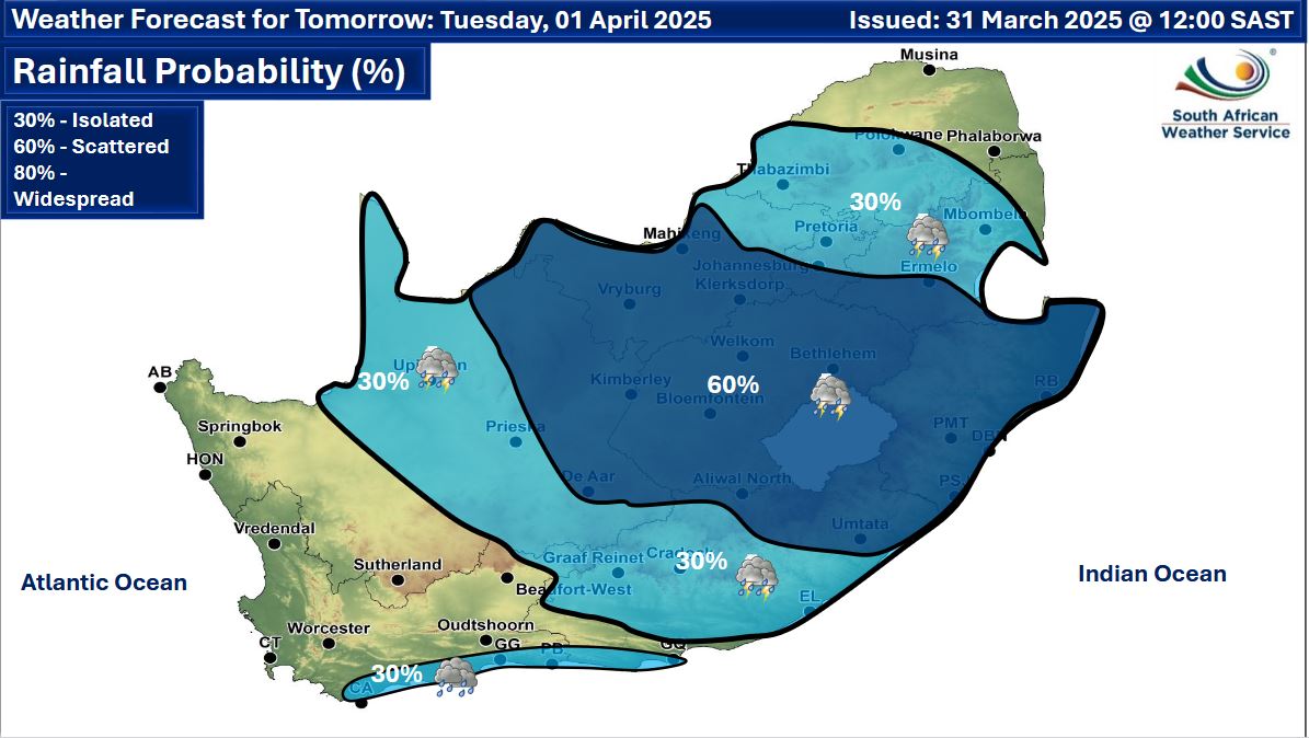
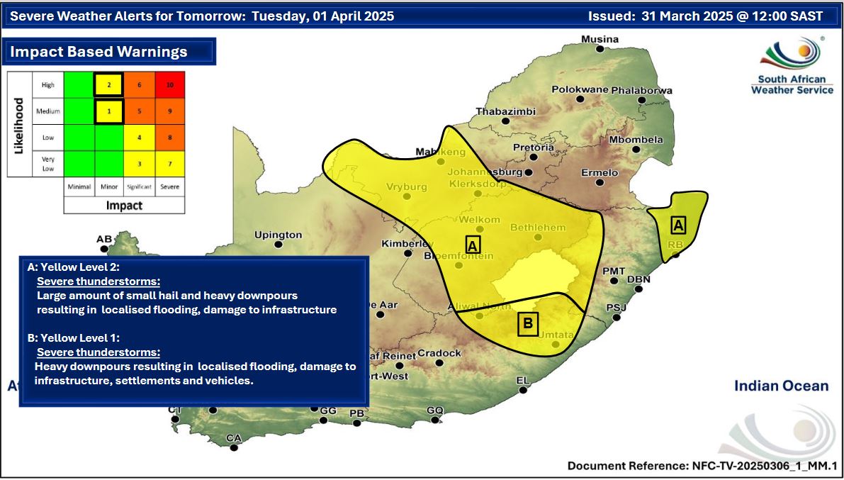
Maps for Tuesday 1 April
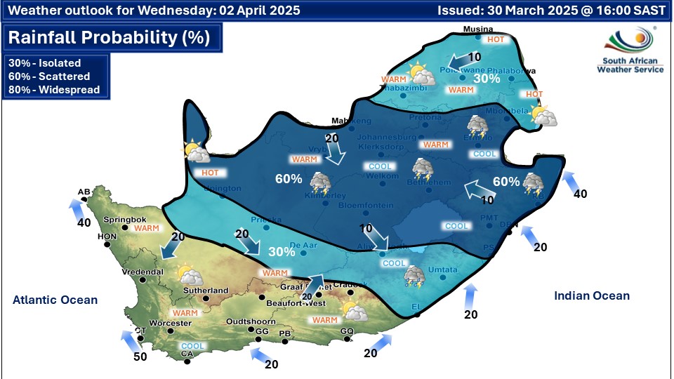
  Maps for Wednesday 2 April
|