
   Swipe left or right for more maps, and see below for others
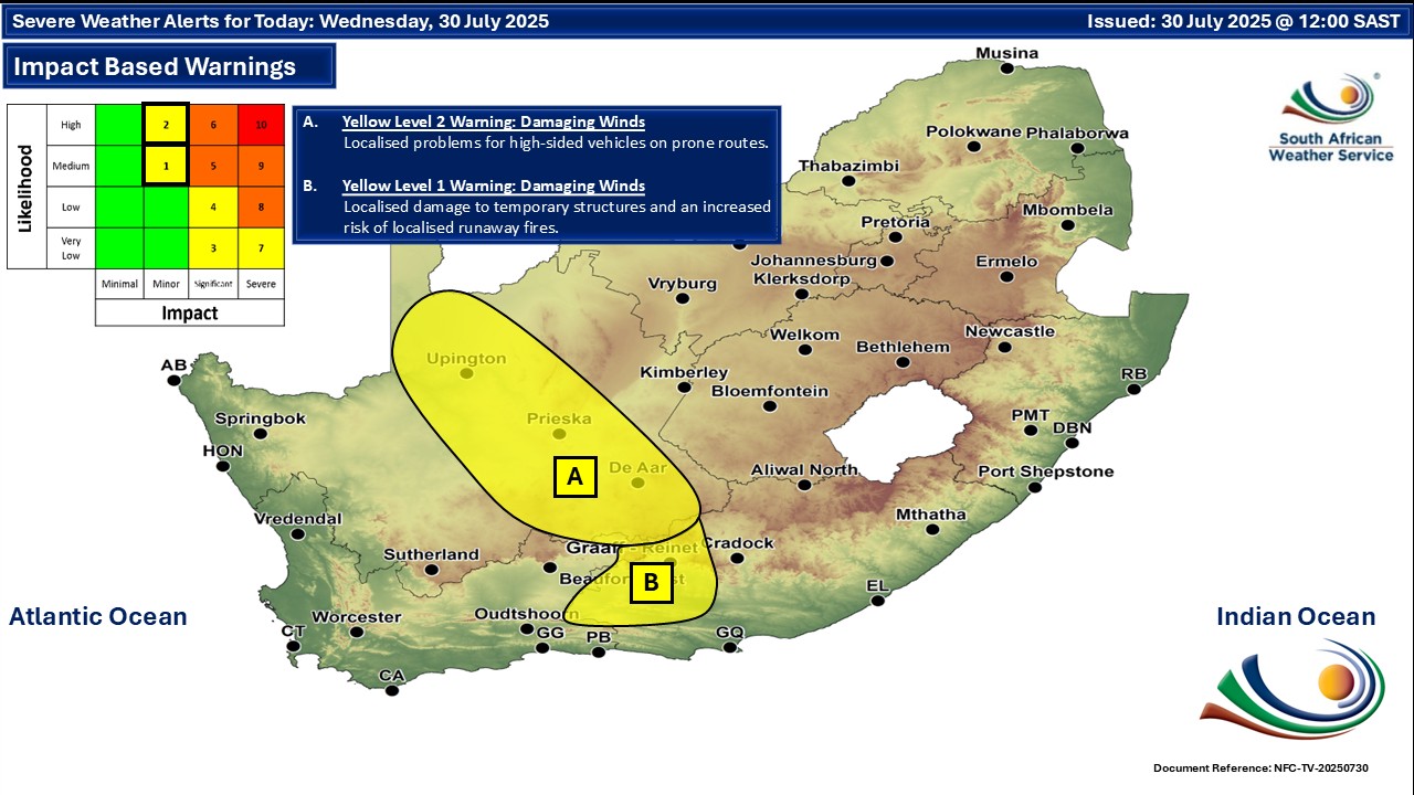
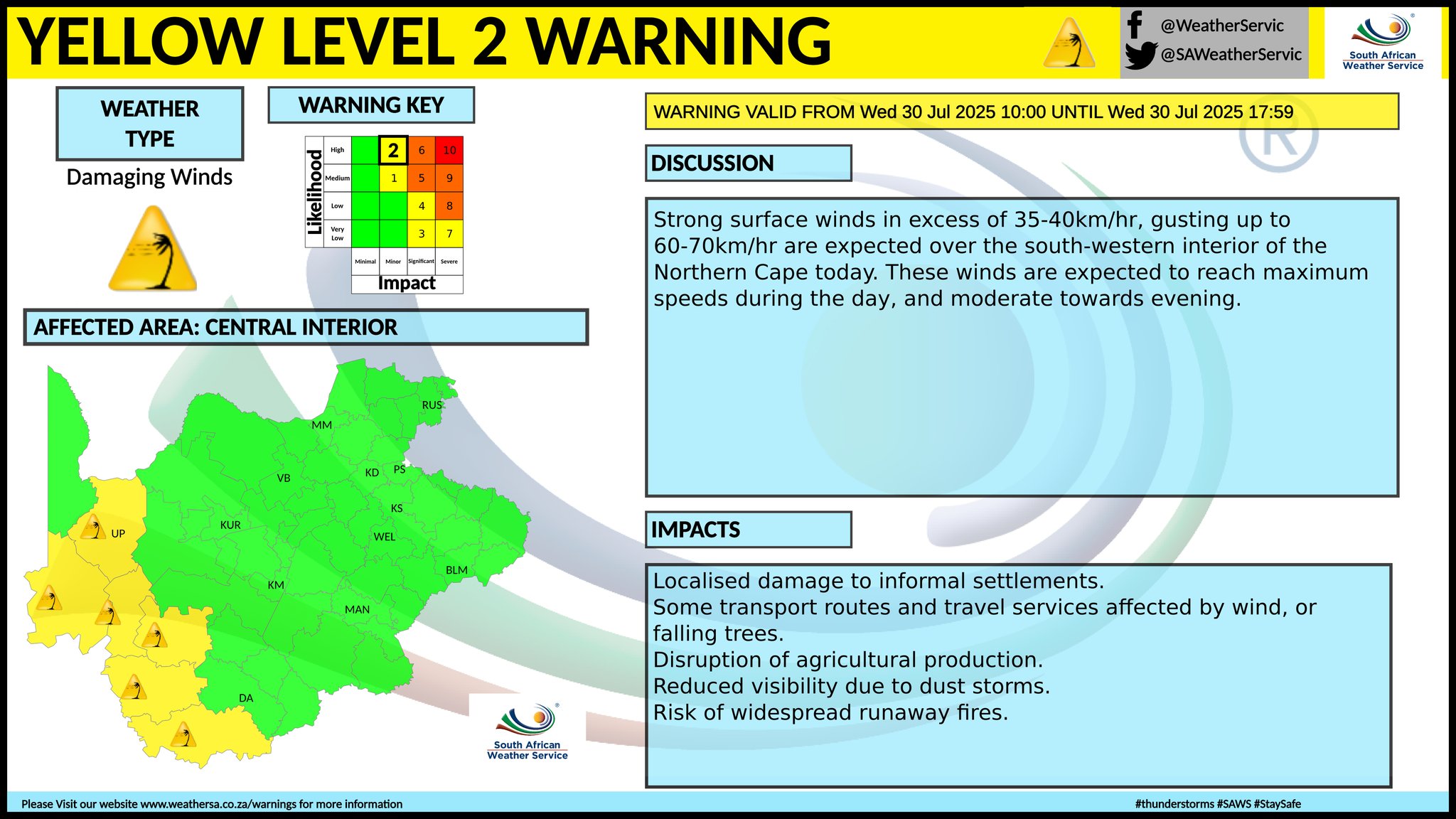
Four warnings issued for Wednesday as another cold front arrivesBy Staff WriterPublished: 29 July 2025 [updated 30 July] This forecast is for: Wed 30 July 2025 The maps cover: Wed 30 Jul – Fri 01 Aug
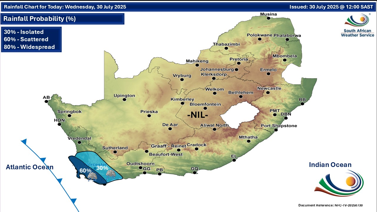
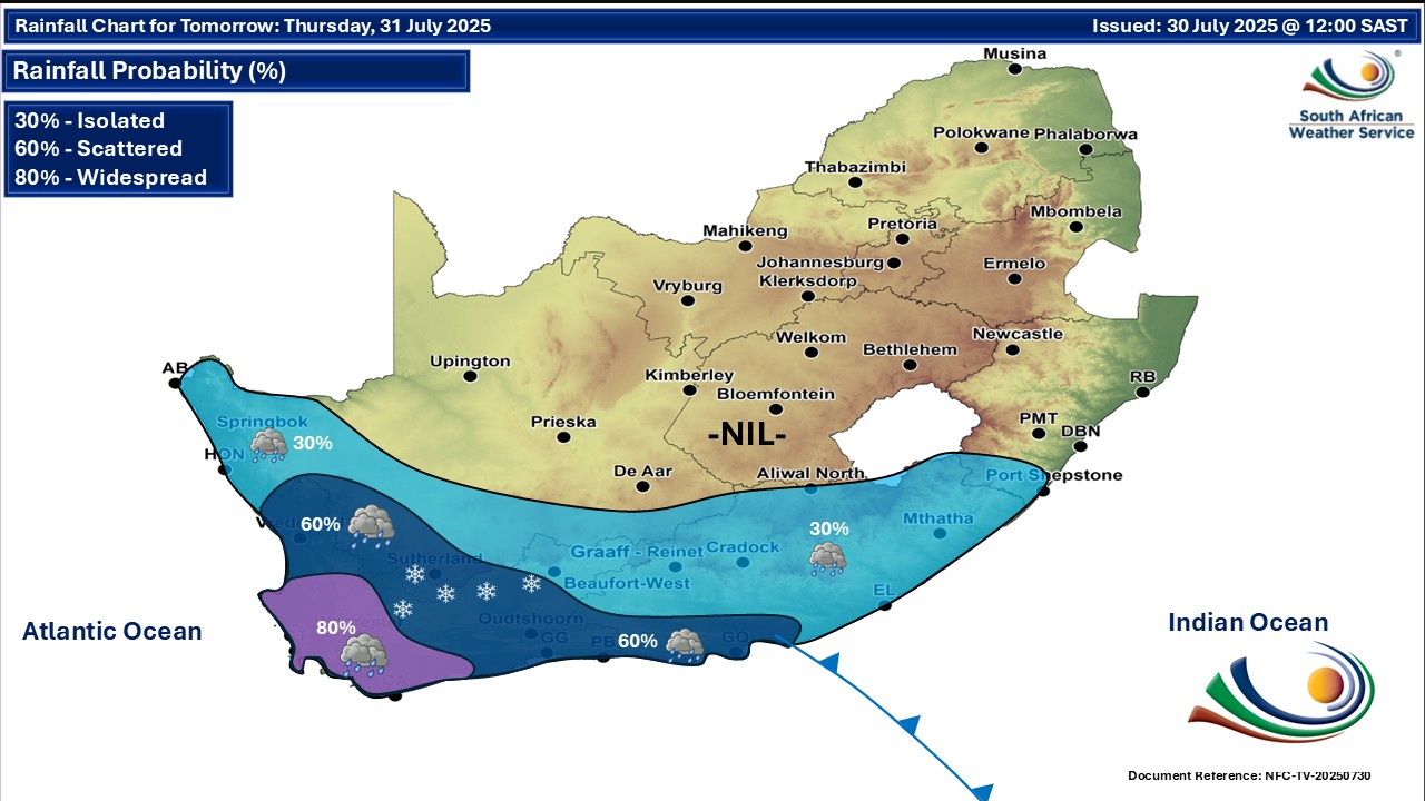
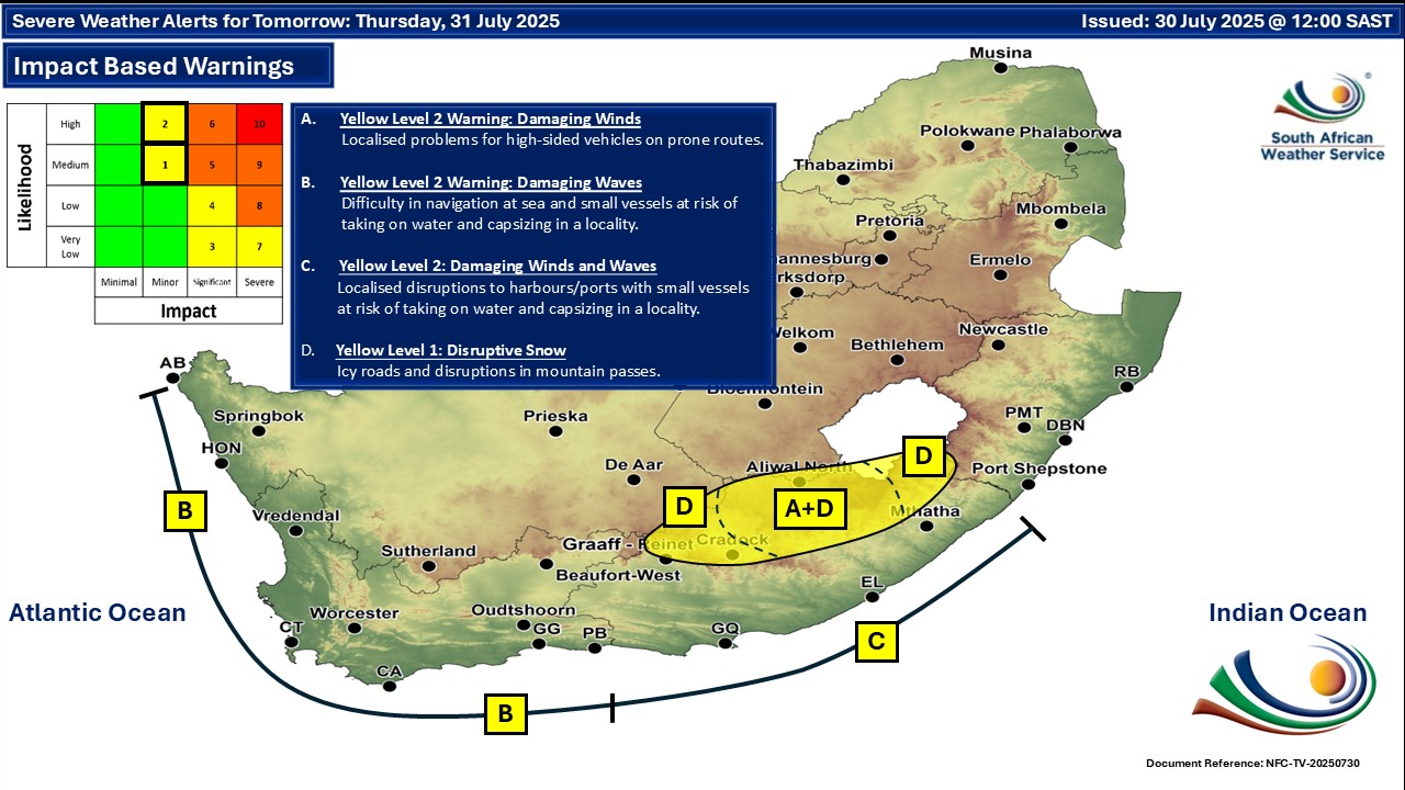
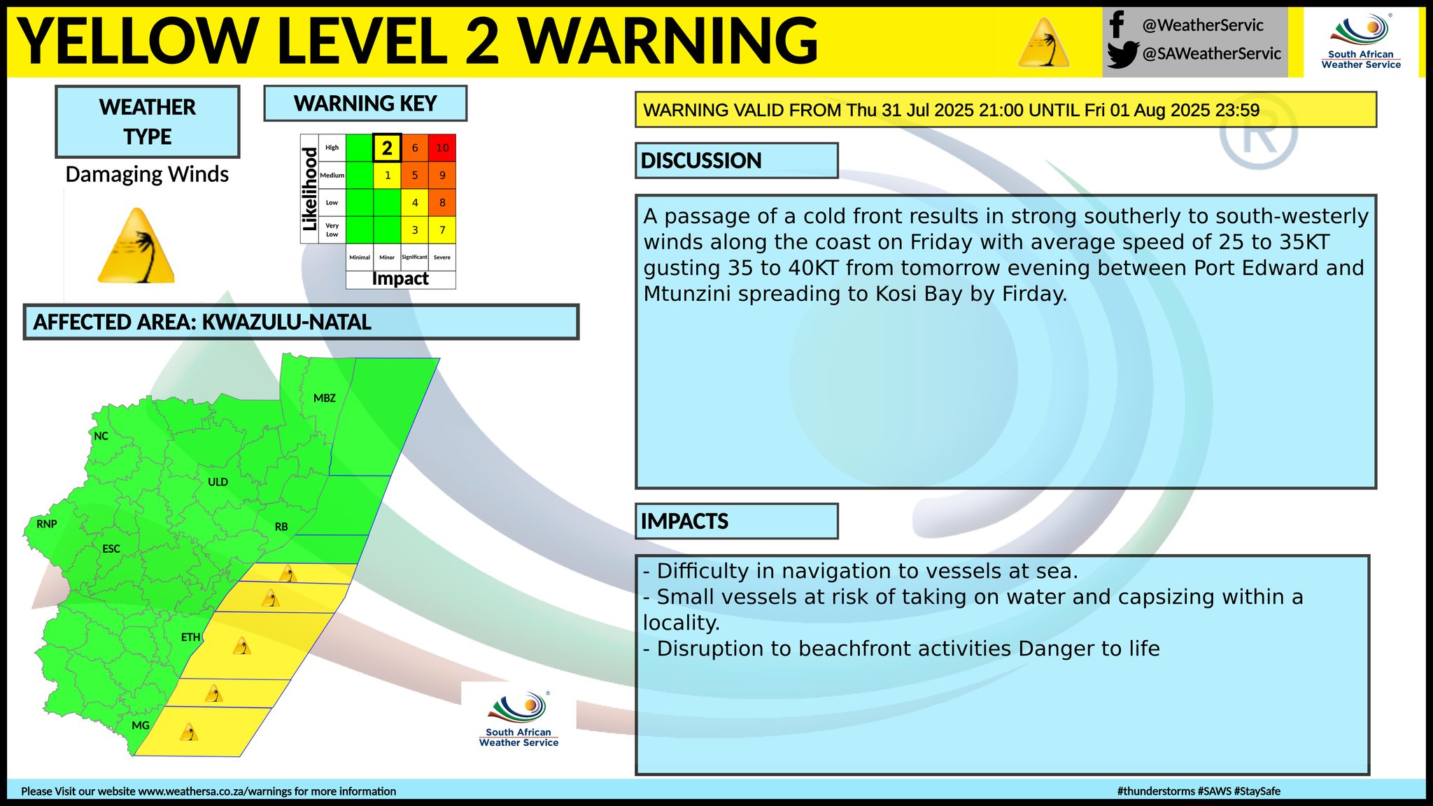
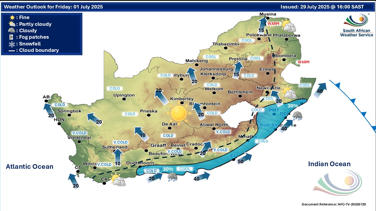
A newer forecast is available by clicking here. You can listen to this daily weather forecast as a 4 minute podcast by pressing the > play button above. Very cold, wet and windy conditions are expected over the southern parts of the Namakwa district (Northern Cape), as well as over the Cape Winelands, Central Karoo and Little Karoo Municipalities of the Western Cape on Thursday. SEE ALSO: Snowfall possible in three SA provinces and Lesotho – disruptive snowfall warning issued. Warnings from the SA Weather Service for Wednesday: A. level 2 warning for damaging winds resulting in localised problems for high-sided vehicles on prone routes over the south-western parts of the Northern Cape. B. level 1 warning for damaging winds resulting in localised damage to temporary structures and an increased risk of localised runaway fires in places over Dr Beyers Naude local municipality of the Eastern Cape. C. level 1 warning for damaging winds resulting in localised damage to temporary structures and localised power and communication interruptions in places over Chris Hani and Joe Gqabi district municipalities of the Eastern Cape. Some warnings from the SA Weather Service for Thursday: level 1 warning for disruptive snow in parts of the Eastern Cape, as per the map below. level 2 warning for damaging waves between Saldanha Bay and Cape Agulhas on Thursday morning, spreading to Plettenberg Bay and Alexander Bay in the afternoon, subsiding from Friday morning. level 2 warning for damaging winds with gusts of 74-84 km/h in parts of the Eastern Cape, as per the map below. level 2 warning for damaging winds with gusts of 35-40 knots along the coast of the KwaZulu-Natal, as per the map below. level 2 warning for damaging waves along the coast of the Eastern Cape, as per the map below. Regional forecasts from the SA Weather Service for Wednesday: 1. GAUTENG Fine and cool in the north. The expected UVB sunburn index: High 2. MPUMALANGA Fine and cool to cold but warm in Lowveld. 3. LIMPOPO Fine and cool. 4. NORTH-WEST PROVINCE Fine and cool. 5. FREE STATE Fine and cold to cool. 6. NORTHERN CAPE Cloudy with morning fog along the coast and adjacent interior, otherwise partly cloudy, windy and cool to warm. It will be fine in places over the interior. The wind along the coast will be moderate north-westerly. 7. WESTERN CAPE Cloudy with morning drizzle and fog in places along the west, otherwise partly cloudy and cold to cool but warm in the east. Rain is expected over the south-western parts from late afternoon. The wind along the coast will be moderate to fresh north-westerly but strong in the south-west. The expected UVB sunburn index: Low 8. WESTERN HALF OF THE EASTERN CAPE Partly cloudy in places, otherwise fine and warm, but windy over the interior. It will become cloudy along the coast from late morning. The wind along the coast will be moderate to fresh north-westerly, becoming south-westerly from the west from mid-morning. 9. EASTERN HALF OF THE EASTERN CAPE Fine, windy and cool in places in the west, but warm along the coast and adjacent interior. The wind along the coast will be moderate to fresh north-westerly, becoming north-easterly in the afternoon. 10. KWAZULU-NATAL Fine and cool to warm. The wind along the coast will be moderate to fresh northerly to north-easterly. The expected UVB sunburn index: Very High Travellers forecasts from the SA Weather Service for Wednesday: PRETORIA Fine. Minimum/Maximum: 3/20°C The expected UVB Sunburn Index: High JOHANNESBURG Fine. Minimum/Maximum: 2/19°C VEREENIGING Fine. Minimum/Maximum: 0/18°C MBOMBELA Fine. Minimum/Maximum: 4/21°C POLOKWANE Fine. Minimum/Maximum: 3/19°C MAHIKENG Fine. Minimum/Maximum: 2/19°C VRYBURG Fine. Minimum/Maximum: 0/21°C BLOEMFONTEIN Fine. Minimum/Maximum: 1/18°C KIMBERLEY Fine. Minimum/Maximum: 5/22°C UPINGTON Partly cloudy and windy. Minimum/Maximum: 13/25°C CAPE TOWN Mostly cloudy with morning drizzle and rain from the afternoon. Wind: Fresh to strong north-westerly. Minimum/Maximum: 13/16°C The expected UVB Sunburn Index: Low GEORGE Partly cloudy. Wind: Fresh north-westerly. Minimum/Maximum: 13/25°C GQEBERHA Fine, becoming partly cloudy in the afternoon. Wind: Moderate to fresh north-westerly, becoming south-westerly in the afternoon. Minimum/Maximum: 11/28°C EAST LONDON Fine, becoming partly cloudy in the afternoon. Wind: Moderate to fresh north-westerly, becoming north-easterly in the afternoon. Minimum/Maximum: 16/30°C DURBAN Fine. Wind: Light northerly to north-westerly until midday and in the evening, otherwise moderate to fresh northerly to north-easterly. Minimum/Maximum: 11/22°C The expected UVB Sunburn Index: Very High RICHARDS BAY Fine. Wind: Moderate to fresh northerly to north-easterly. Minimum/Maximum: 13/24°C PIETERMARITZBURG Fine. Minimum/Maximum: 5/25°C This forecast is usually updated a few times per day.
Please be sure to send photos and videos to us via whatsapp and also tell us where and when they were taken. Follow our channels
Maps for Thursday 31 July
       Maps for Friday 1 August
 Note date on map above is incorrect - should be 1 Aug
|