
THURSDAY WEATHER: A LEVEL 6 thunderstorm warning for the interior – flooding possible
By Staff WriterPublished: 29 April 2026
This forecast is for: Thu 30 April 2026
The maps cover: Thu 30 Apr – Thu 30 Apr
| SHARE TO |
The latest forecast is available by clicking here.
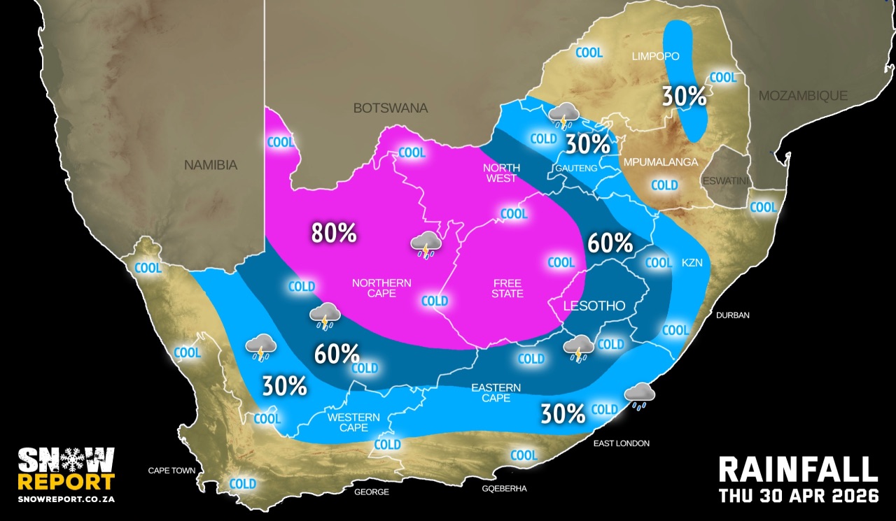
A cut-off low is currently situated to the west of the country and is expected to make landfall over the western interior of South Africa on Thursday morning, resulting in widespread rainfall up to 90mm in places.
The cut-off low will gradually move eastwards and is expected to exit the country by Friday.
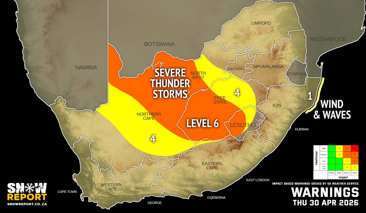
Warnings from the SA Weather Service for Thursday:
A. level 6 warning for severe thunderstorms resulting in damage or loss of infrastructures, settlements, property, vehicles, livelihoods and livestock, injuries and danger to life, and major travel disruptions the western parts of both Free State and North West, and the north-eastern parts of the Northern Cape.
B. level 4 warning for severe thunderstorms resulting in damages to infrastructure, settlements, property, vehicles, livelihoods, and livestock, injuries and danger to life, as well as major travel disruptions, are the central parts of North-West, central and eastern Free State, and central interior of the Northern Cape.
C. level 1 warning for damaging wind and waves leading to difficulty in navigation, localised disruption on small harbours and ports for a short period of time, small vessels at risk of taking on water and capsizing in a locality, localised damage to coastal infrastructure and localised disruptions to beachfront activities are expected between Richards Bay and Kosi Bay.
SEE ALSO: Snowfall possible for Lesotho, the Drakensberg and the Eastern Cape on the long weekend.
Regional forecasts from the SA Weather Service for Thursday:
GAUTENG
Fog in places in the morning, otherwise cloudy and cool with isolated showers and thundershowers in the afternoon.
MPUMALANGA
Fog in places in the morning, otherwise cloudy and cool to warm.
LIMPOPO
Fog in places in the morning, with drizzle along the escarpment, otherwise cloudy and cool to warm.
NORTH-WEST
Cloudy, windy and cool with scattered to widespread showers and thundershowers, but isolated in the extreme east.
THE FREE STATE
Cloudy, windy and cold to cool with scattered to widespread showers and thundershowers, but isolated in the extreme east.
THE NORTHERN CAPE
Partly cloudy and cool but cloudy, windy and cold over the central and eastern parts where it will be windy in places. Isolated showers and and thundershowers are expected over the western interior, but scattered to widespread over the central and eastern parts. The wind along the coast will be moderate southerly to south-westerly.
THE WESTERN CAPE
Fine over the central and western parts, otherwise partly cloudy and cool to warm but cloudy over the north-eastern parts with isolated afternoon showers and thundershowers. The wind along the coast will be moderate to fresh south-westerly over the west coast but light over the south coast becoming moderate in the evening.
THE WESTERN HALF OF THE EASTERN CAPE
Partly cloudy and cool with isolated showers and thundershowers over the central and northern parts. The wind along the coast will be light northerly becoming light south-westerly in the evening.
THE EASTERN HALF OF THE EASTERN CAPE
Partly cloudy and cool with isolated showers and thundershowers but scattered in the north and widespread in the extreme north. The wind along the coast will be light northerly to easterly.
KWAZULU-NATAL
Morning fog over the extreme north-west, otherwise partly cloudy and cool to warm but cold in the south-west. Scattered showers and thundershowers are expected in the south-west, otherwise isolated, except in the eastern central and north-eastern parts. The wind along the coast will be light to moderate north-westerly until mid-morning, otherwise light to moderate northerly to north-easterly, becoming light to moderate southerly to south-westerly in the south by the evening.
Travellers forecasts from the SA Weather Service for Thursday:
PRETORIA
Morning fog in places, otherwise cloudy with isolated afternoon showers and thundershowers.
Minimum/Maximum: 09/21°C
JOHANNESBURG
Morning fog in places, otherwise cloudy with isolated afternoon showers and thundershowers.
Minimum/Maximum: 08/18°C
VEREENIGING
Morning fog in places, otherwise cloudy with isolated afternoon showers and thundershowers.
Minimum/Maximum: 06/20°C
MBOMBELA
Cloudy with morning fog.
Minimum/Maximum: 14/23°C
POLOKWANE
Cloudy.
Minimum/Maximum: 14/17°C
MAHIKENG
Cloudy and windy with scattered showers and thundershowers.
Minimum/Maximum: 14/21°C
VRYBURG
Cloudy and windy, with widespread showers and thundershowers.
Minimum/Maximum: 14/20°C
BLOEMFONTEIN
Cloudy and windy, with widespread showers and thundershowers.
Minimum/Maximum: 10/14°C
KIMBERLEY
Cloudy and windy with widespread showers and thundershowers.
Minimum/Maximum: 11/14°C
UPINGTON
Cloudy and windy with widespread showers and thundershowers.
Minimum/Maximum: 14/16°C
CAPE TOWN
Fine.
Wind
Moderate to fresh south-westerly.
Minimum/Maximum: 14/20°C
GEORGE
Fine, becoming partly cloudy in the afternoon.
Wind: Light and variable, becoming moderate south-westerly in the evening.
Minimum/Maximum: 08/19°C
GQEBERHA
Partly cloudy.
Wind: Light northerly becoming light southwesterly in the evening.
Minimum/Maximum: 13/20°C
EAST LONDON
Fine, becoming partly cloudy with isolated showers and thundershowers.
Wind: Light northerly to easterly.
Minimum/Maximum: 14/21°C
DURBAN
Partly cloudy.
Wind: Light northerly to north-westerly until mid-morning, otherwise light north-easterly, becoming light to moderate south-westerly in the evening.
Minimum/Maximum: 16/24°C
RICHARDS BAY
Partly cloudy, becoming fine in the evening.
Wind: Light northerly to north-westerly until mid-morning, otherwise light to moderate north-easterly, reaching fresh in the afternoon.
Minimum/Maximum: 15/27°C
PIETERMARITZBURG
Partly cloudy with isolated showers and thundershowers.
Minimum/Maximum: 08/22°C
This forecast is usually updated a few times per day.
| SHARE TO |
Please be sure to send photos and videos to us via whatsapp and also tell us where and when they were taken.
Follow our channels