
     Swipe left or right for more maps, and see below for others
Cold fronts bringing cold, wet and windy weather with multiple warnings including for snow from ThursdayBy Staff WriterPublished: 2 July 2025 [updated 3 July] This forecast is for: Thu 03 July 2025 The maps cover: Thu 03 Jul – Sat 05 Jul
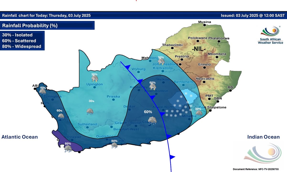
A newer forecast is available by clicking here. You can listen to this daily weather forecast as a 3 minute podcast by pressing the > play button above. A series of cold fronts are expected to bring scattered to widespread showers and rain over the western parts of the Western Cape from Thursday until Sunday. The most significant cold front will reach the south-western Cape by Friday afternoon, where quick and heavy downpours are possible, with another cold front expected on Sunday. Rainfall accumulations of 30-60mm are likely over the south-western parts over the four days, reaching 70-90mm over the mountainous region with most of the rainfall expected from Friday into Saturday, according to the SA Weather Service. Continuous rainfall together with saturated soils will lead to significant impacts. ALSO READ: More snowfall possible due to cold fronts and cut-off low, incuding Johannesburg and eight SA provinces. Warnings from the SA Weather Service for Thursday: A. level 4 warning for disruptive rainfall leading to flooding of roads and danger to life due to fast flowing streams over low-lying bridges over the western parts of the Western Cape. B. level 1 warning for damaging wind leading to localised damage to settlements (formal and informal) as well as risk of localised runaway fires over the extreme south-western parts of the Northwest, extreme south-eastern part of the Northern Cape and the western parts of the Free State. C. level 1 warning for severe thunderstorms with large amounts of small hail, damaging winds and excessive lightning leading to localised damage to settlements, falling trees, flying debris in places over the northern parts of the Eastern Cape. D. level 1 warning for disruptive snowfall in the regions of Jamestown, Barkly East, Maclear and Matatiele in the Eastern Cape from the late afternoon on Thursday until late on Friday. Extremely high for danger conditions are expected over the Tokologo local municipality in the Free State. Regional forecasts from the SA Weather Service for Thursday: 1. GAUTENG Cloudy and cool to cold with isolated showers and thundershowers in the south-west. The expected UVB sunburn index: High 2. MPUMALANGA Warm in the Lowveld, otherwise partly cloudy and cool. It will be cloudy in the south-west. 3. LIMPOPO Partly cloudy and cool, but warm in the Lowveld and the Limpopo Valley. 4. NORTH-WEST PROVINCE Party cloudy, windy and warm with isolated showers and thundershowers except over the extreme north-east. It will be cloudy in the south-east. 5. FREE STATE Partly cloudy in the north-west, otherwise cloudy, windy and cool to cold with isolated to scattered showers and thundershowers, except in the extreme east. 6. NORTHERN CAPE Cloudy in the west with morning fog in the extreme west, otherwise partly cloudy, windy and cool to cold with isolated to scattered showers and thundershowers. It will be very cold in places in the south. The wind along the coast will be light to moderate in the north-west. 7. WESTERN CAPE Morning fog over the central parts, otherwise cloudy and cool to cold with isolated to scattered showers and rain but wide-spread in the south-west. The wind along the coast will be fresh to strong westerly to north-westerly, but fresh south-westerly along the west coast. The expected UVB sunburn index: Low 8. WESTERN HALF OF THE EASTERN CAPE Cloudy and cool with scattered showers and thundershowers. The wind along the coast will be light northerly, becoming fresh to strong south-westerly in the afternoon. 9. EASTERN HALF OF THE EASTERN CAPE Cloudy and cool, but cold in places in the north. Scattered showers and thundershowers are expected, but isolated in the east. The wind along the coast will be moderate to fresh north-easterly, becoming moderate south-westerly by late afternoon. 10. KWAZULU-NATAL Partly cloudy and cool with isolated showers and rain over the south-western parts. It will be fine and warm in the east. The wind along the coast will be moderate to fresh northerly to north-easterly. The expected UVB sunburn index: Very High Travellers forecasts from the SA Weather Service for Thursday: PRETORIA Cloudy. Minimum/Maximum: 06/20°C The expected UVB Sunburn Index: High JOHANNESBURG Cloudy. Minimum/Maximum: 06/19°C VEREENIGING Cloudy with isolated showers and thundershowers. Minimum/Maximum: 01/18°C MBOMBELA Fine. Minimum/Maximum: 07/23°C POLOKWANE Partly cloudy. Minimum/Maximum: 07/20°C MAHIKENG Partly cloudy and windy with isolated showers and thundershowers. Minimum/Maximum: 09/22°C VRYBURG Partly cloudy and windy with isolated showers and thundershowers. Minimum/Maximum: 09/21°C BLOEMFONTEIN Cloudy and windy with scattered showers and thundershowers. Minimum/Maximum: 06/19°C KIMBERLEY Partly cloudy and windy with scattered showers and thundershowers. Minimum/Maximum: 10/20°C UPINGTON Partly cloudy and windy, with isolated showers and thundershowers. Minimum/Maximum: 09/16°C CAPE TOWN Cloudy with widespread showers and rain. Wind: moderate to fresh southerly to south-westerly. Minimum/Maximum: 12/14°C The expected UVB Sunburn Index: Low GEORGE Cloudy with isolated showers and rain. Wind: Moderate to fresh westerly to north-westerly. Minimum/Maximum: 12/18°C GQEBERHA Cloudy with scattered showers and thundershowers. Wind: fresh to strong south-westerly. Minimum/Maximum: 15/21°C EAST LONDON Cloudy with scattered showers and thundershowers. Wind: Moderate to fresh north-easterly. Minimum/Maximum: 15/24°C DURBAN Fine. Wind: moderate northerly to north-easterly. Minimum/Maximum: 12/25°C The expected UVB Sunburn Index: Very High RICHARDS BAY Fine. Wind: Moderate to fresh northerly to north-easterly. Minimum/Maximum: 15/28°C PIETERMARITZBURG Fine. Minimum/Maximum: 03/24°C This forecast is usually updated a few times per day.
Please be sure to send photos and videos to us via whatsapp and also tell us where and when they were taken. Follow our channels
Maps for Friday 4 July
   Maps for Saturday 5 July
 
|