
  Maps partly based on data from the SA Weather Service
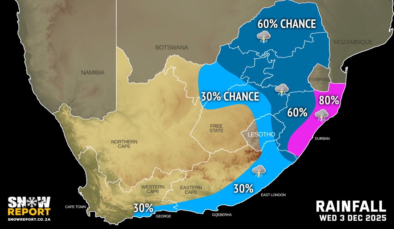
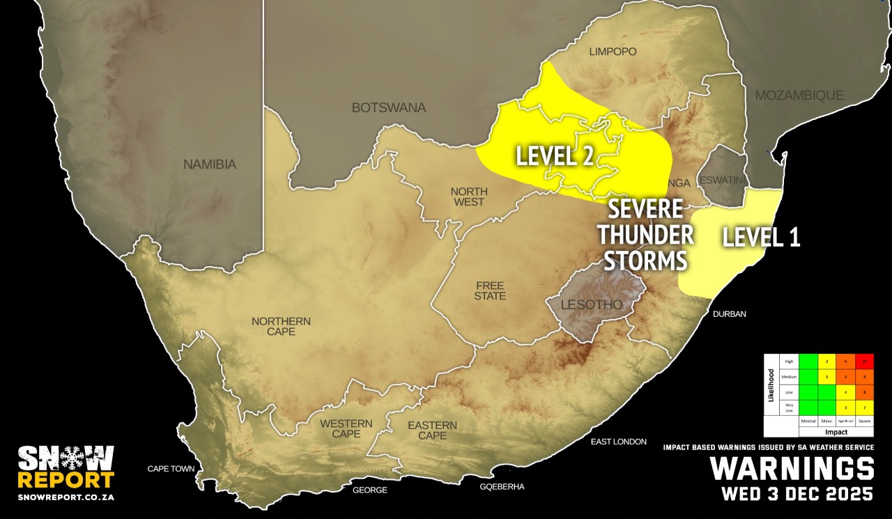
WEDNESDAY WEATHER: Rain or thunderstorms in the east and the south coastBy Staff WriterPublished: 2 December 2025 This forecast is for: Wed 03 December 2025 The maps cover: Wed 03 Dec – Wed 03 Dec
The latest forecast is available by clicking here. It will be cooler in some parts of the country on Wednesday. Partly cloudy and cool conditions are expected over the central and eastern parts of South Africa on Wednesday with isolated to scattered showers and thundershowers. Hot to very hot and uncomfortable conditions are expected over the Kamiesberg local municipality in the Northern Cape, as well as over the west coast district in the Western Cape until Thursday, but only on Thursday over the Cape Winelands, Little Karoo, as well as western parts of central Karoo district. Warnings from the SA Weather Service for Wednesday: A. level 2 warning severe thunderstorms leading to localised damages to infrastructure, property, vehicles, and injuries (livelihood and livestock) due to hail, damaging winds, heavy downpours and excessive lightning, over the eastern North West, Gauteng, western Mpumalanga and south-western regions of Limpopo. B: level 1 warning severe thunderstorms leading to localised damages to infrastructure, property, vehicles, and injuries (livelihood and livestock) due to hail, damaging winds, heavy downpours and excessive lightning, over the north-eastern regions of KwaZulu-Natal. Extremely high fire danger conditions are expected over the north central parts of the Northern Cape. Regional forecasts from the SA Weather Service for Wednesday: GAUTENG Partly cloudy and cool to warm with scattered showers and thundershowers from the afternoon. MPUMALANGA Partly cloudy and cool to warm with scattered showers and thundershowers. LIMPOPO Partly cloudy and warm to hot with scattered showers and thundershowers. NORTH WEST Partly cloudy and hot with scattered afternoon showers and thundershowers from early afternoon. THE FREE STATE Morning fog patches in the east where it will be cloudy, otherwise partly cloudy and cool to warm, with isolated showers and thundershowers in the north. THE NORTHERN CAPE Partly cloudy in the extreme east, otherwise fine and warm to hot but very hot in the north central. The wind along the coast will be fresh to strong southerly to south-easterly. THE WESTERN CAPE Partly cloudy with isolated showers and rain over the extreme south-eastern parts in the morning, otherwise fine and hot to very hot but cool to warm in places over the southern parts. The wind along the coast will be fresh to strong southerly to south-easterly, becoming fresh easterly to north-easterly along the south-coast in the evening. THE WESTERN HALF OF THE EASTERN CAPE Cloudy in the morning, otherwise fine and cool. The wind along the coast will be light to moderate southerly to south-westerly. THE EASTERN HALF OF THE EASTERN CAPE Partly cloudy and cool with a 30% chance of light rain south of the escarpment, but cloudy along the wild coast. The wind along the coast will be moderate southerly to south-westerly. KWAZULU-NATAL Partly cloudy in the extreme west, otherwise cloudy and cool to cold with scattered showers and thundershowers but widespread in the east. The wind along the coast will be light to moderate southerly to south-easterly. Travellers forecasts from the SA Weather Service for Wednesday: PRETORIA Partly cloudy with scattered showers and thundershowers from the afternoon. Minimum/Maximum: 15/27°C JOHANNESBURG Partly cloudy with scattered showers and thundershowers from the afternoon. Minimum/Maximum: 13/24°C VEREENIGING Partly cloudy with scattered showers and thundershowers from the afternoon. Minimum/Maximum: 13/25°C MBOMBELA Partly cloudy with scattered showers and thundershowers. Minimum/Maximum: 12/25°C POLOKWANE Partly cloudy with scattered showers and thundershowers. Minimum/Maximum: 14/26°C MAHIKENG Partly cloudy, with isolated showers and thundershowers from early afternoon. Minimum/Maximum: 16/32°C VRYBURG Partly cloudy. Minimum/Maximum: 15/32°C BLOEMFONTEIN Partly cloudy. Minimum/Maximum: 13/27°C KIMBERLEY Partly cloudy. Minimum/Maximum: 16/32°C UPINGTON Fine. Minimum/Maximum: 17/29°C CAPE TOWN Fine. Wind: Moderate to fresh southerly to south-easterly. Minimum/Maximum: 17/29°C GEORGE Cloudy with isolated showers and rain in the morning, otherwise fine. Wind: Light to moderate south-easterly, becoming light to moderate easterly to north-easterly in the evening. Minimum/Maximum: 16/22°C GQEBERHA Cloudy in the morning with a 30% chance of light rain, otherwise partly cloudy. Wind: Light to moderate southerly to south-westerly. Minimum/Maximum: 16/20°C EAST LONDON Partly cloudy with a 30% chance of morning light rain. Wind: Moderate southerly to south-westerly. Minimum/Maximum: 17/19°C DURBAN Cloudy with widespread showers and thundershowers. Wind: Moderate southerly to south-easterly. Minimum/Maximum: 19/21°C RICHARDS BAY Cloudy with widespread showers and thundershowers. Wind: Moderate southerly to south-easterly. Minimum/Maximum: 19/23°C PIETERMARITZBURG Cloudy with widespread showers and thundershowers. Minimum/Maximum 15/18°C This forecast is usually updated a few times per day.
Please be sure to send photos and videos to us via whatsapp and also tell us where and when they were taken. Follow our channels
|