
   Maps partly based on data from the SA Weather Service
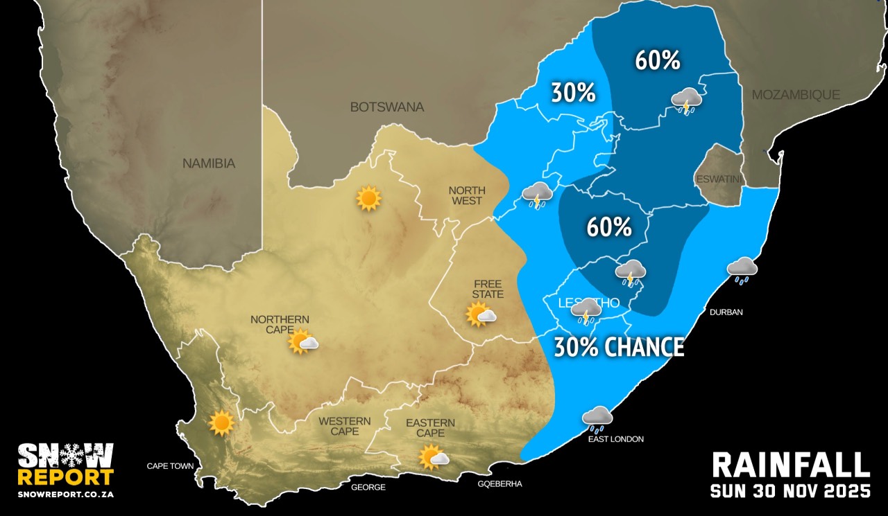
SATURDAY WEATHER: Fog in every province and severe thunderstorms warnings for five provincesBy Staff WriterPublished: 28 November 2025 [updated 29 November] This forecast is for: Sat 29 November 2025 The maps cover: Sat 29 Nov – Sun 30 Nov
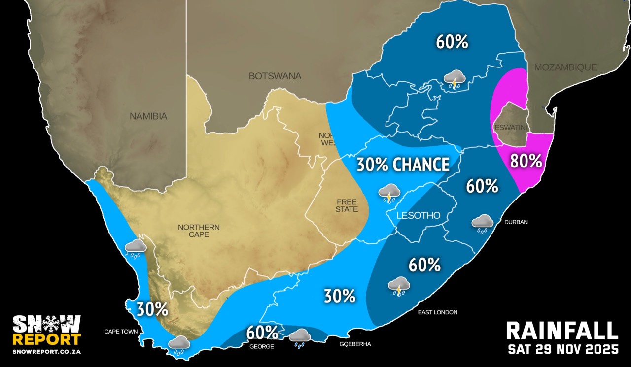
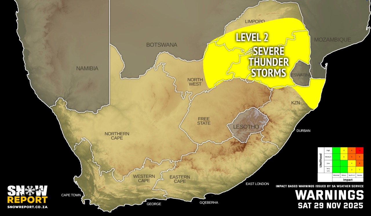
The latest forecast is available by clicking here. Warnings from the SA Weather Service for Saturday: A. level 2 warning severe thunderstorms with heavy downpours resulting in localised flooding of susceptible roads and low-level bridges, strong winds and possible large amount of hail in places are expected over Gauteng, Mpumalanga and north-eastern part of KwaZulu-Natal, including southern half of Limpopo and eastern half of North West. Regional forecasts from the SA Weather Service for Saturday: GAUTENG Cloudy in the morning with fog patches, otherwise partly cloudy and cool to warm with scattered showers and thundershowers. MPUMALANGA Morning fog patches over the Highveld, otherwise partly cloudy and cool to warm with scattered showers and thundershowers, but widespread over the Escarpment and Lowveld. LIMPOPO Morning fog patches over the western part, otherwise cloudy and cool to warm with scattered showers and thundershowers, but widespread over the Escarpment and Lowveld. NORTH-WEST Morning fog patches over the east, otherwise partly, windy and cool to warm, with isolated showers and thundershowers except over the western parts where it will be fine. THE FREE STATE Morning fog patches over north-east, otherwise partly and cool to warm, with isolated showers and thundershowers except over the western parts. THE NORTHERN CAPE Morning fog patches over the western part, otherwise fine and warm to hot, becoming partly cloudy in the afternoon. It will become cloudy with light rain along the coast and adjacent interior in the evening. The wind along the coast will be moderate to fresh southerly. THE WESTERN CAPE Morning fog patches over the north-western part where it will be hot, otherwise cloudy and cool to warm, becoming partly cloudy in the afternoon except in the south-west. Light rain is expected over the southern and western parts, clearing from the west by the afternoon. The wind along the coast will be fresh to strong southerly to south-westerly. THE WESTERN HALF OF THE EASTERN CAPE Cool in places along the coast, otherwise cloudy and warm with isolated showers and thundershowers. The wind along the coast will be fresh to strong south-westerly, becoming light to moderate west of Cape St Francis from the afternoon. THE EASTERN HALF OF THE EASTERN CAPE Morning fog patches over the north-east, otherwise cloudy and cool to warm with scattered showers and thundershowers. The wind along the coast will be moderate to fresh north-easterly north of Mazeppa Bay early morning, otherwise fresh to strong south-westerly, becoming light to moderate in the evening. KWAZULU-NATAL Cloudy at times, otherwise partly cloudy and cool to warm with isolated to scattered showers and thundershowers but widespread in the extreme north-east.Morning fog is expected over the central interior. The wind along the coast will be moderate to fresh north-easterly becoming south-westerly from the south towards mid morning, spreading northwards in the afternoon. Travellers forecasts from the SA Weather Service for Saturday: PRETORIA Cloudy in the morning with fog patches, otherwise partly cloudy with scattered showers and thundershowers. Minimum/Maximum: 14/25°C JOHANNESBURG Cloudy in the morning with fog patches, otherwise partly cloudy with scattered showers and thundershowers. Minimum/Maximum: 12/23°C VEREENIGING Cloudy in the morning, otherwise partly cloudy with scattered showers and thundershowers. Minimum/Maximum: 12/25°C MBOMBELA Cloudy in the morning, otherwise partly cloudy with scattered showers and thundershowers. Minimum/Maximum: 18/23°C POLOKWANE Cloudy in the morning, otherwise partly cloudy with scattered showers and thundershowers. Minimum/Maximum: 15/25°C MAHIKENG Partly cloudy and windy with isolated showers and thundershowers. Minimum/Maximum: 18/30°C VRYBURG Partly cloudy and windy. Minimum/Maximum: 16/31°C BLOEMFONTEIN Partly cloudy with isolated showers and thundershowers. Minimum/Maximum: 15/28°C KIMBERLEY Partly cloudy and windy. Minimum/Maximum: 17/28°C UPINGTON Partly cloudy and windy. Minimum/Maximum: 16/29°C CAPE TOWN Cloudy with light morning rain, becoming partly cloudy from the afternoon. Wind: Light to moderate southerly. Minimum/Maximum: 18/24°C GEORGE Cloudy with light rain at times. Wind: Light to moderate south-westerly. Minimum/Maximum: 18/22°C GQEBERHA Cloudy with isolated showers and rain becoming partly cloudy in the afternoon. Wind: Fresh to strong south-westerly. Minimum/Maximum: 18/25°C EAST LONDON Cloudy with scattered showers and thundershowers, but partly cloudy during the afternoon. Wind: Fresh to strong south-westerly, becoming moderate from the evening. Minimum/Maximum: 19/26°C DURBAN Partly cloudy with scattered showers and thundershowers. Wind: Moderate north-easterly at first, otherwise moderate to fresh south-westerly. Minimum/Maximum: 22/27°C RICHARDS BAY Cloudy at times, otherwise partly cloudy with scattered showers and thundershowers. Wind: Moderate to fresh north-easterly, becoming to strong north-easterly in the afternoon. Minimum/Maximum: 21/34°C PIETERMARITZBURG Morning fog, otherwise partly cloudy with scattered showers and thundershowers. Minimum/Maximum: 15/29°C This forecast is usually updated a few times per day.
Please be sure to send photos and videos to us via whatsapp and also tell us where and when they were taken. Follow our channels
|