
    Swipe left or right for more maps, and see below for others
Rain, strong wind and big waves in the south-west on ThursdayBy Staff WriterPublished: 28 May 2025 [updated 29 May] This forecast is for: Thu 29 May 2025 The maps cover: Thu 29 May – Sun 01 Jun
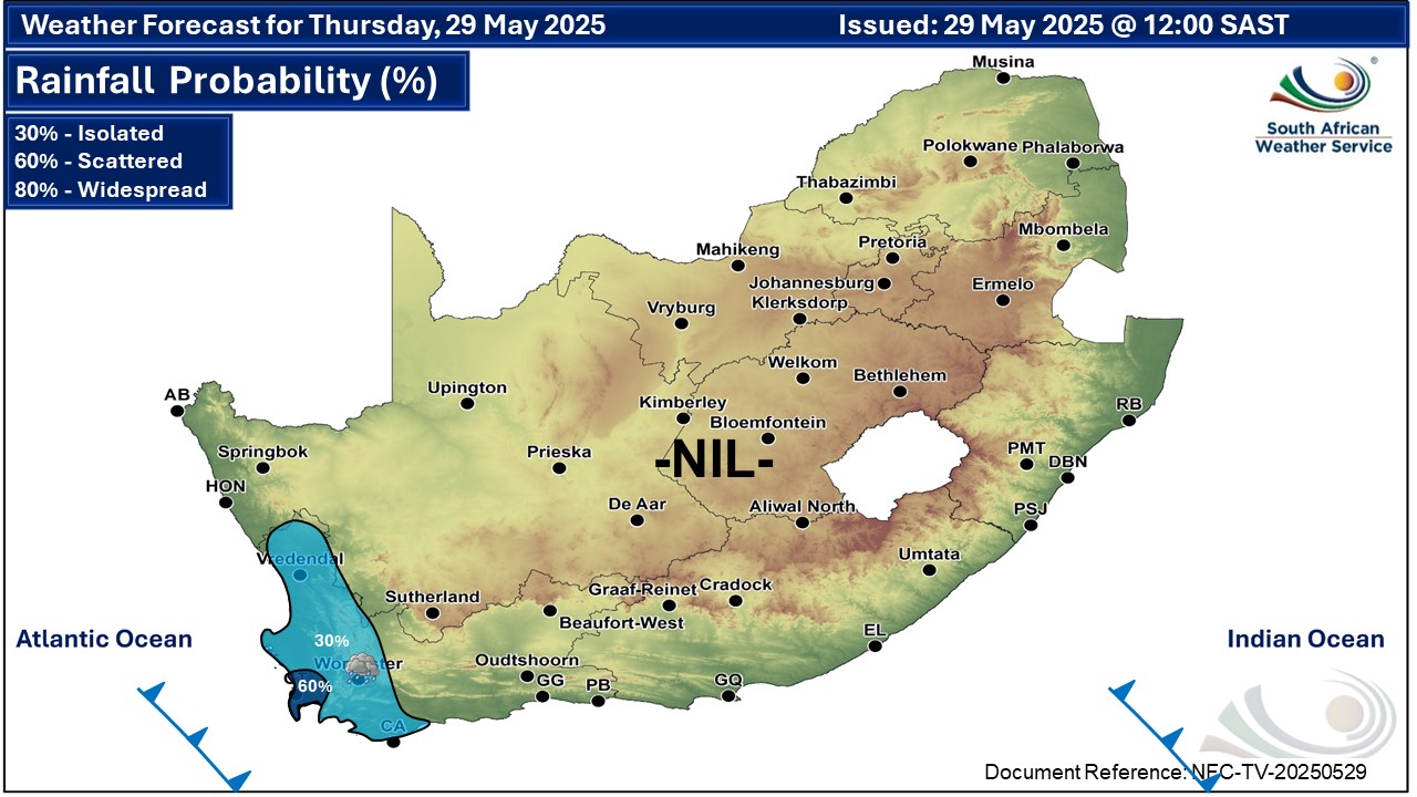
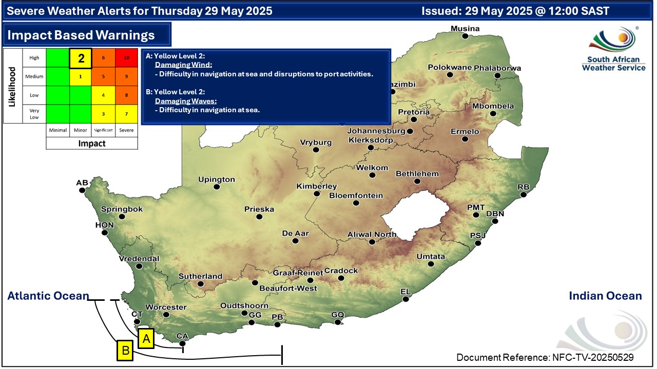
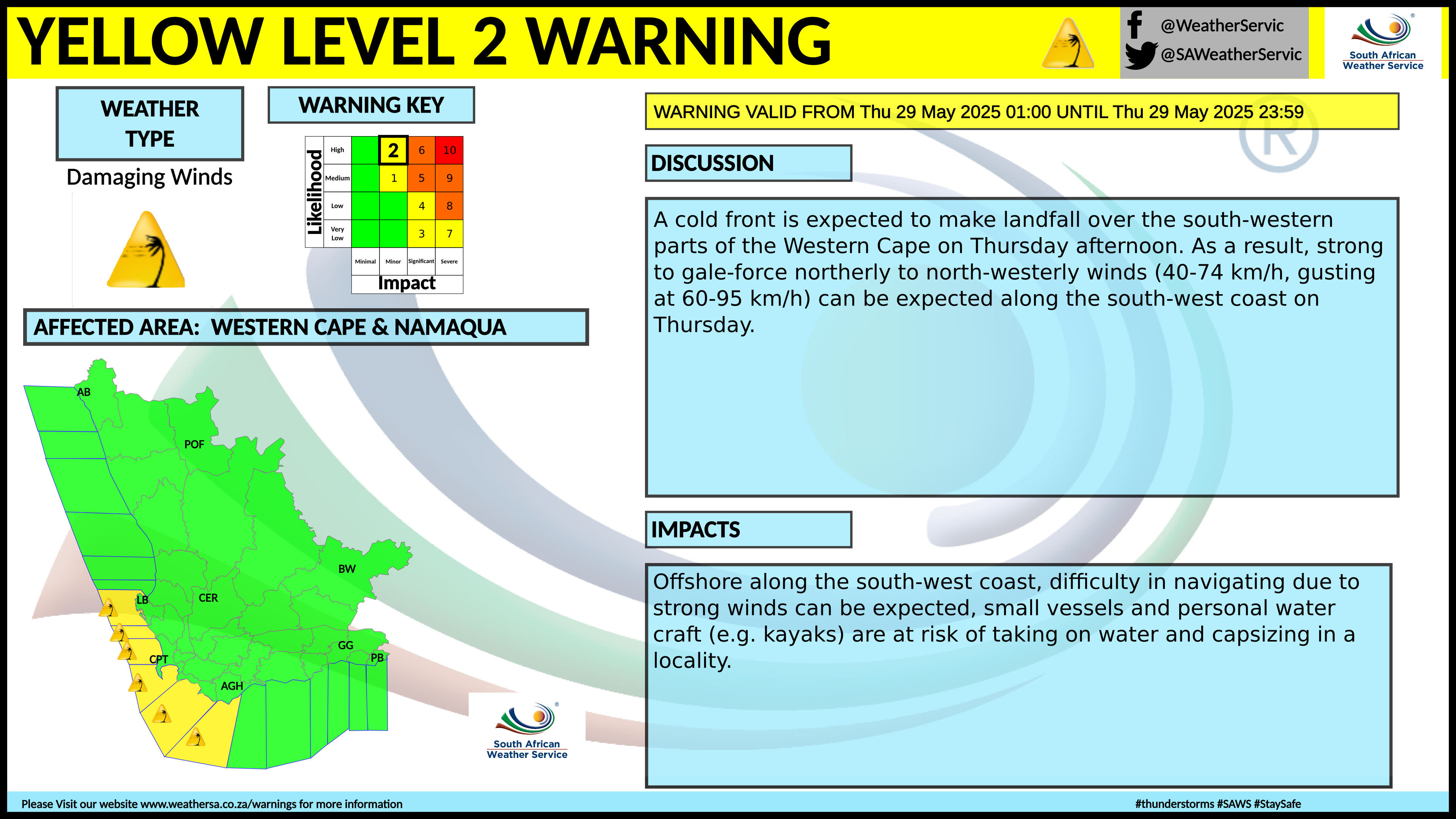
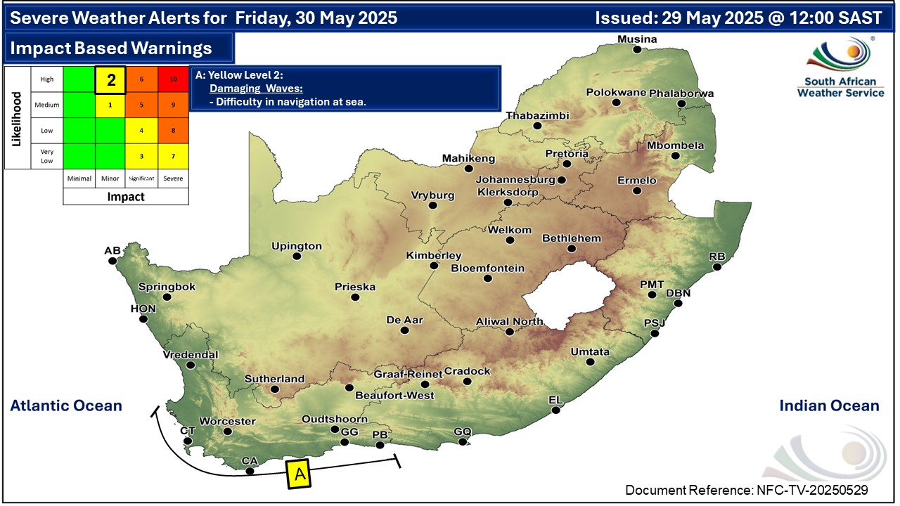
A newer forecast is available by clicking here. Fine and cool to warm across the country but partly cloudy with light rain and showers in the south-west on Wednesday, according to the SA Weather Service (SAWS). Warnings from the SAWS from Thursday: A. level 2 warning for damaging wind leading to difficulty in navigation at sea, is expected between Saldanha Bay and Cape Agulhas. B. level 2 warning for damaging waves leading to difficulty in navigation at sea, are expected between Saldanha Bay and Cape Agulhas, spreading to Plettenberg Bay from Friday until Sunday. Regional forecasts from SAWS for Thursday: 1. GAUTENG Fine and cool. The expected UVB sunburn index: Very High 2. MPUMALANGA Fine and cool to warm. 3. LIMPOPO Fine and cool to warm. 4. NORTH-WEST PROVINCE Fine and cool, with windy conditions in the extreme west. 5. FREE STATE Fine and cool, with windy conditions in the extreme west. 6. NORTHERN CAPE Cloudy to partly cloudy in the west where it will be cold in places, otherwise fine and cool to warm. It will be windy at times in the central and eastern parts. The wind along the coast will be moderate to fresh northerly to north-westerly, becoming light to moderate southerly to south-westerly. 7. WESTERN CAPE Cloudy over the south-western parts with isolated showers and rain, otherwise partly cloudy and cold to cool. The wind along the coast will be fresh to strong northerly to north-westerly, reaching near-gale force along the south-west coast, but strong westerly to south-westerly along the south coast. The expected UVB sunburn index: Low 8. WESTERN HALF OF THE EASTERN CAPE Fine and cool, becoming cloudy with fog in the south-east from the evening. The wind along the coast will be light westerly, becoming south-westerly from midday. 9. EASTERN HALF OF THE EASTERN CAPE Fine and cool to warm, becoming cloudy with fog in places south of the escarpment from the evening. The wind along the coast will be light westerly, becoming south-easterly in the afternoon. 10. KWAZULU-NATAL Fine and cool but warm in the east. The wind along the coast will be light to moderate northerly to north-easterly, reaching fresh in the north, becoming light westerly to south-westerly in the south from the afternoon. The expected UVB sunburn index: Very High Travellers forecasts from SAWS for Thursday: PRETORIA Fine. Minimum/Maximum: 06/22°C The expected UVB Sunburn Index: Very High JOHANNESBURG Fine. Minimum/Maximum: 06/20°C VEREENIGING Fine. Minimum/Maximum: 04/22°C MBOMBELA Fine. Minimum/Maximum: 10/25°C POLOKWANE Fine. Minimum/Maximum: 09/23°C MAHIKENG Fine. Minimum/Maximum: 07/22°C VRYBURG Fine. Minimum/Maximum: 05/23°C BLOEMFONTEIN Fine. Minimum/Maximum: 02/22°C KIMBERLEY Fine and windy. Minimum/Maximum: 08/24°C UPINGTON Fine and windy. Minimum/Maximum: 10/25°C CAPE TOWN Cloudy with isolated showers and rain. Wind: Moderate to fresh north to north-westerly. Minimum/Maximum: 14/19°C The expected UVB Sunburn Index: Low GEORGE Partly cloudy. Wind: Moderate north-westerly becoming light south-westerly from the afternoon. Minimum/Maximum: 11/22°C GQEBERHA Fine. Wind: Light westerly, becoming south-westerly towards midday. Minimum/Maximum: 13/21°C EAST LONDON Fine. Wind: Light westerly, becoming south-easterly in the afternoon. Minimum/Maximum: 15/23°C DURBAN Fine. Wind: Light north-westerly until mid-morning, otherwise north-easterly, becoming light and variable from late afternoon. Minimum/Maximum: 15/26°C The expected UVB Sunburn Index: Very High RICHARDS BAY Fine. Wind: Light to moderate northerly to north-easterly. Minimum/Maximum: 16/28°C PIETERMARITZBURG Fine. Minimum/Maximum: 09/27°C This forecast is usually updated a few times per day.
Please be sure to send photos and videos to us via whatsapp and also tell us where and when they were taken. Follow our channels
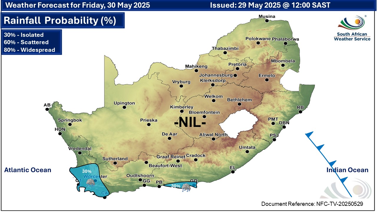
Maps for Friday 30 May
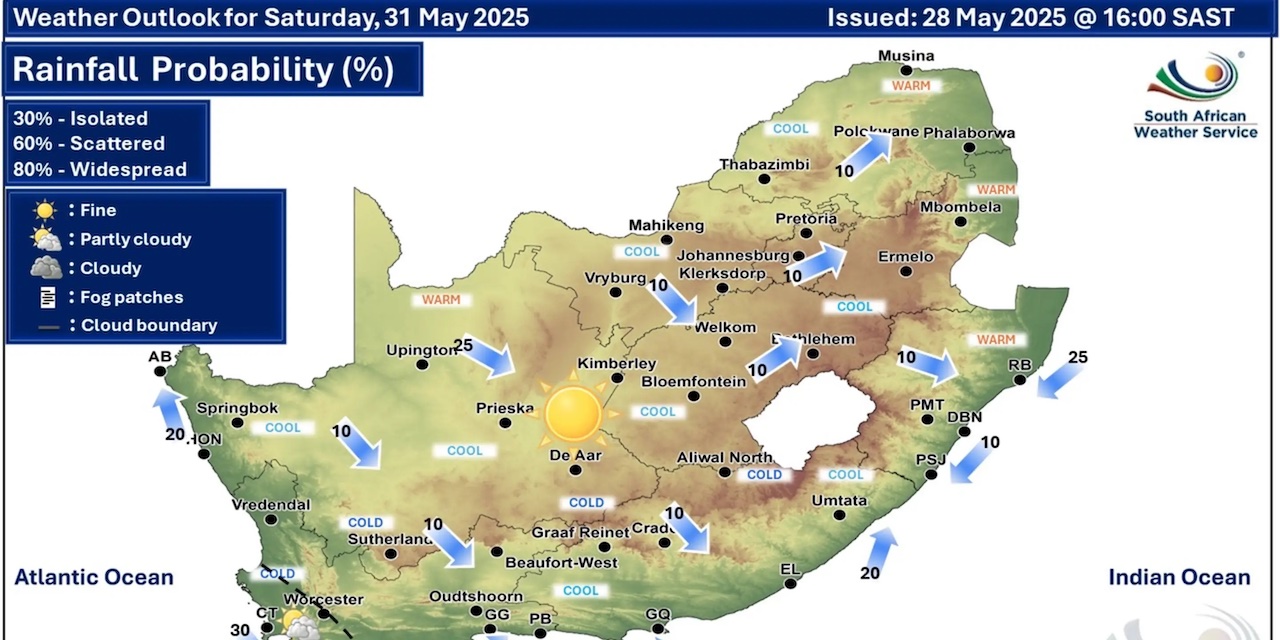
  Maps for Saturday 31 May
|