

WEDNESDAY WEATHER: Cold overnight with thunderstorms, fog and frost
By Staff WriterPublished: 28 April 2026
This forecast is for: Wed 29 April 2026
The maps cover: Wed 29 Apr – Wed 29 Apr
| SHARE TO |
The latest forecast is available by clicking here.
Conditions favourable for frost are expected along the Lesotho border, the southern parts of both Free State and Northern Cape as well as the northern parts of the Eastern Cape.
Morning or evening fog can be expected in some parts of the country.
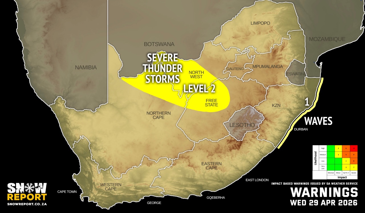
Warnings from the SA Weather Service for Wednesday:
A. level 2 warning for severe thunderstorms with heavy downpours, leading to localised flooding and damages to susceptible formal/informal settlements and infrastructure over the western parts of North West, the north-western parts of Free State as well as the north-eastern parts of Northern Cape.
B. level 1 warning for damaging waves resulting in localised disruption of small harbours and/or a port for a short period of time, small vessels at risk of taking on water and capsizing in a locality, and difficulty in navigation between Port Edward and Kosi Bay.
SEE ALSO: Snowfall possible for Lesotho, the Drakensberg and the Eastern Cape on the long weekend.
Regional forecasts from the SA Weather Service for Wednesday:
GAUTENG
Fine at first, otherwise partly cloudy and cool, but warm in the north, with isolated showers and thundershowers.
MPUMALANGA
Morning fog along the escarpment, otherwise cloudy and cold to cool with isolated showers and thundershowers.
LIMPOPO
Morning fog along the escarpment, otherwise cloudy and cold to cool with isolated showers and thundershowers. It will become partly cloudy over the western and central parts by the afternoon.
NORTH WEST
Partly cloudy and cool with scattered showers and thundershowers over the western parts, otherwise isolated.
THE FREE STATE
Morning fog patches in the extreme eastern parts, otherwise fine and cool, becoming partly cloudy with scattered showers and thundershowers, but isolated in the extreme eastern and southern parts.
THE NORTHERN CAPE
Morning fog in the extreme south-west where it will be cold, otherwise partly cloudy and cool to warm with isolated to scattered showers and thundershowers in the central and eastern parts but fine in the extreme west. The wind along the coast will be moderate southerly to south-easterly becoming fresh to strong in the evening.
THE WESTERN CAPE
Morning fog patches over the Overberg and Cape Winelands Valley, otherwise fine and cool to warm. The wind along the coast will be light to moderate easterly to south-easterly becoming fresh to strong in the evening along the west coast.
THE WESTERN HALF OF THE EASTERN CAPE
Partly cloudy along the coast at first, otherwise fine and cold, but cool along the coast. wind along the coast will be light westerly becoming light south-easterly to easterly in the evening.
THE EASTERN HALF OF THE EASTERN CAPE
Fine and cold, but cool in places along the coast. Morning frost is expected in places near the Free State border. The wind along the coast will be light westerly becoming light north-easterly overnight.
KWAZULU-NATAL
Fine in the extreme south with morning and evening fog over the extreme north-western interior, otherwise cloudy and cool but cold in the extreme south-west. It will become partly cloudy from the afternoon with isolated showers and rain in the extreme north-west. The wind along the coast will be moderate to fresh south-westerly, becoming light to moderate southerly to south-easterly from the afternoon but light northerly to north-westerly in the south in the evening.
Travellers forecasts from the SA Weather Service for Wednesday:
PRETORIA
Fine at first, otherwise partly cloudy with isolated showers and thundershowers.
Minimum/Maximum: 09/23°C
JOHANNESBURG
Fine at first, otherwise partly cloudy with isolated showers and thundershowers.
Minimum/Maximum: 07/22
VEREENIGING
Fine at first, otherwise partly cloudy with isolated showers and thundershowers.
Minimum/Maximum: 07/21°C
MBOMBELA
Morning fog patches, otherwise cloudy with isolated showers and thundershowers.
Minimum/Maximum: 15/18°C
POLOKWANE
Cloudy becoming partly cloudy in the afternoon with isolated showers and thundershowers.
Minimum/Maximum: 13/20°C
MAHIKENG
Partly cloudy, with isolated showers and thundershowers.
Minimum/Maximum: 09/21°C
VRYBURG
Partly cloudy, with scattered showers and thundershowers.
Minimum/Maximum: 06/20°C
BLOEMFONTEIN
Fine becoming partly cloudy, with scattered showers and thundershowers.
Minimum/Maximum: 01/20°C
KIMBERLEY
Fine becoming partly cloudy, with scattered showers and thundershowers.
Minimum/Maximum: 03/20°C
UPINGTON
Partly cloudy, with scattered showers and thundershowers.
Minimum/Maximum: 06/25°C
CAPE TOWN
Fine.
Wind: Light and moderate in the morning, otherwise fresh to strong south-easterly.
Minimum/Maximum: 12/21°C
GEORGE
Fine.
Wind: Light and variable in the morning becoming moderate easterly to south-easterly in the evening.
Minimum/Maximum: 09/18°C
GQEBERHA
Partly cloudy becoming fine.
Wind: Light westerly becoming light southeasterly to easterly in the evening.
Minimum/Maximum: 13/18°C
EAST LONDON
Fine.
Wind: Light westerly becoming light northeasterly overnight.
Minimum/Maximum: 14/21°C
DURBAN
Cloudy in the morning and evening, otherwise partly cloudy.
Wind: Light south-westerly, becoming south-easterly in the afternoon but north-westerly in the evening.
Minimum/Maximum: 15/23°C
RICHARDS BAY
Cloudy in the morning and evening, otherwise partly cloudy.
Wind: Light to moderate south-westerly, becoming south-easterly late afternoon but north-westerly in the evening.
Minimum/Maximum: 15/24°C
PIETERMARITZBURG
Cloudy in the morning and evening, otherwise partly cloudy.
Minimum/Maximum: 05/20°C
This forecast is usually updated a few times per day.
| SHARE TO |
Please be sure to send photos and videos to us via whatsapp and also tell us where and when they were taken.
Follow our channels