
       Swipe left or right for more maps
Rainfall, thunderstorms, hail continue on Tuesday with warnings affecting six provincesBy Staff WriterPublished: 27 October 2025 This forecast is for: Tue 28 October 2025 The maps cover: Tue 28 Oct – Thu 30 Oct
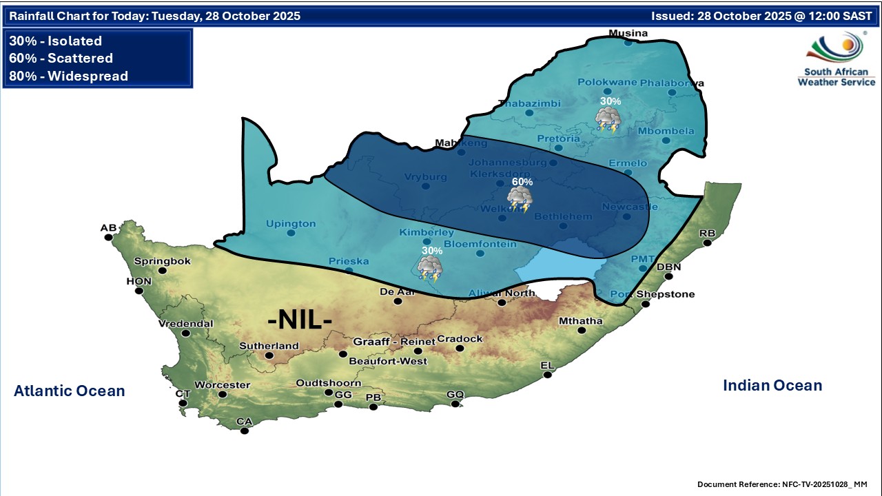
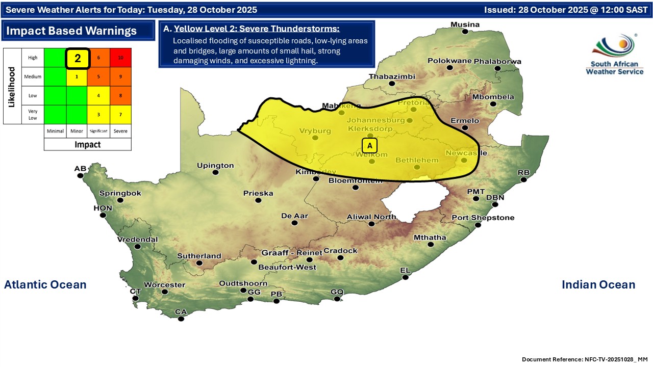
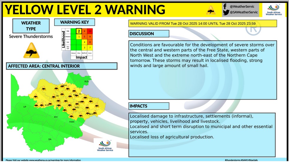
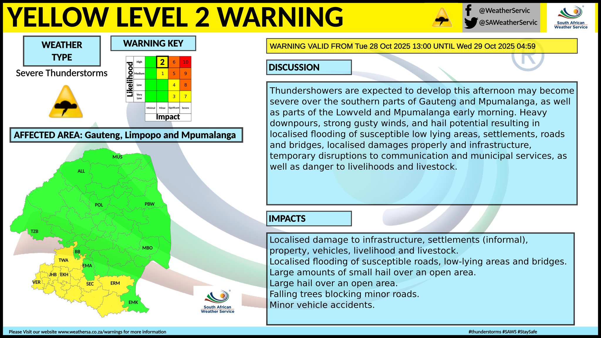
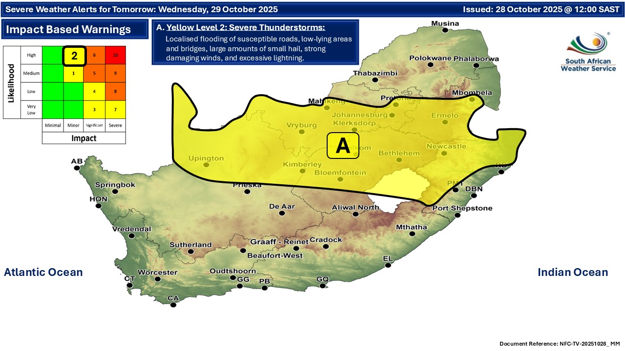
The latest forecast is available by clicking here. Rainfall and thunderstorms will continue into the middle of the week. Warnings from the SA Weather Service for Tuesday: A. level 2 warning for severe thunderstorms resulting in localised flooding of susceptible roads, low-lying areas and bridges, large amount of small hail, strong damaging winds as well as localised damage to settlements over an open area the Central parts of Limpopo (morning), western parts of North West, northern and central parts of Free State, south parts of Gauteng and Mpumalanga as well as the north-western parts of KwaZulu-Natal. Extremely high fire danger conditions are expected over the Kamiesberg local municipality of the Northern Cape. Regional forecasts from the SA Weather Service for Tuesday: GAUTENG Partly cloudy and warm with isolated showers and thundershowers but scattered in the south. The expected UVB sunburn index: Very High MPUMALANGA Partly cloudy in the Highveld, otherwise cloudy and cool but warm in the Lowveld with isolated showers and thundershowers but scattered in the extreme southeast. LIMPOPO Cloudy in the east otherwise partly cloudy and cool to warm with isolated showers and thundershowers but scattered over the central parts in the morning. NORTH-WEST Partly cloudy and warm to hot, with scattered showers and thundershowers, but isolated in the east. THE FREE STATE Partly cloudy and warm to hot, with scattered showers and thundershowers, but isolated in the west. THE NORTHERN CAPE Fine in the west and southern parts, otherwise partly cloudy, and warm to hot, with isolated showers and thundershowers, but scattered in the extreme northeast. The wind along the coast will be moderate to fresh south-easterly becoming strong from the afternoon THE WESTERN CAPE Partly cloudy over the south-west in the morning and along the south coast in the evening, otherwise fine and cool to warm. The wind along the coast will be moderate south-westerly along the south coast in the morning, otherwise moderate to fresh southerly to south-easterly but strong along the west coast. The expected UVB sunburn index: Very High THE WESTERN HALF OF THE EASTERN CAPE Fine and warm, but cool along the coast. The wind along the coast will be Light and variable. THE EASTERN HALF OF THE EASTERN CAPE Cloudy along the wild coast and adjacent interior, otherwise partly cloudy and warm but cool along the coast. The wind along the coast will be Light to moderate westerly. KWAZULU-NATAL Partly cloudy to cloudy and cool to warm with isolated showers and thundershowers but scattered in the north-west. The wind along the coast will be light to moderate southerly to south-westerly in the north, otherwise light to moderate northerly to north-easterly spreading northwards from the afternoon. The expected UVB sunburn index: Low Travellers forecasts from the SA Weather Service for Tuesday: PRETORIA Partly cloudy with isolated showers and thundershowers. Minimum/Maximum: 18/27°C The expected UVB Sunburn Index: Very High JOHANNESBURG Partly cloudy with scattered showers and thundershowers. Minimum/Maximum: 15/26°C VEREENIGING Partly cloudy with scattered showers and thundershowers. Minimum/Maximum: 18/28°C MBOMBELA Cloudy with isolated afternoon showers and thundershowers. Minimum/Maximum: 17/21°C POLOKWANE Partly cloudy with scattered showers and thundershowers. Minimum/Maximum: 15/20°C MAHIKENG Partly cloudy, with scattered showers and thundershowers. Minimum/Maximum: 17/31°C VRYBURG Partly cloudy, with scattered showers and thundershowers. Minimum/Maximum: 13/32°C BLOEMFONTEIN Fine, becoming partly cloudy in the afternoon, with isolated showers and thundershowers. Minimum/Maximum: 13/31°C KIMBERLEY Fine, becoming partly cloudy in the afternoon, with isolated showers and thundershowers. Minimum/Maximum: 13/31°C UPINGTON Partly cloudy, with isolated showers and thundershowers. Minimum/Maximum: 15/32°C CAPE TOWN Partly cloudy in the morning otherwise fine. Wind: Light to moderate southerly in the morning, otherwise fresh. Minimum/Maximum: 13/23°C The expected UVB Sunburn Index: Very High GEORGE Fine becoming partly cloudy from evening. Wind: Light north-westerly in the morning, otherwise light to moderate southerly to south-easterly. Minimum/Maximum: 10/21°C GQEBERHA Fine. Wind: Light north-westerly, becoming southerly. Minimum/Maximum: 11/21°C EAST LONDON Fine. Wind: Light and variable, becoming easterly by afternoon, but north-easterly by evening. Minimum/Maximum: 14/22°C DURBAN Partly cloudy to cloudy with isolated morning showers and rain. Wind: Light to moderate northerly to north-easterly. Minimum/Maximum: 18/23°C The expected UVB Sunburn Index: Low RICHARDS BAY Partly cloudy to cloudy with isolated morning showers and rain. Wind: Light to moderate southerly to south-westerly, becoming light to moderate northerly to north-easterly in the afternoon. Minimum/Maximum: 19/24°C PIETERMARITZBURG Partly cloudy to cloudy with isolated showers and thundershowers. Minimum/Maximum: 12/23°C This forecast is usually updated a few times per day.
Please be sure to send photos and videos to us via whatsapp and also tell us where and when they were taken. Follow our channels
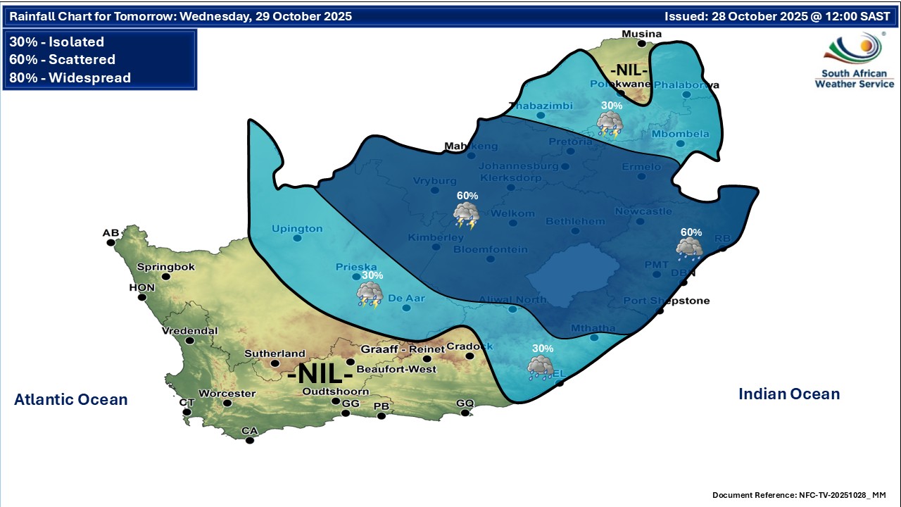
Maps for Wednesday 29 October
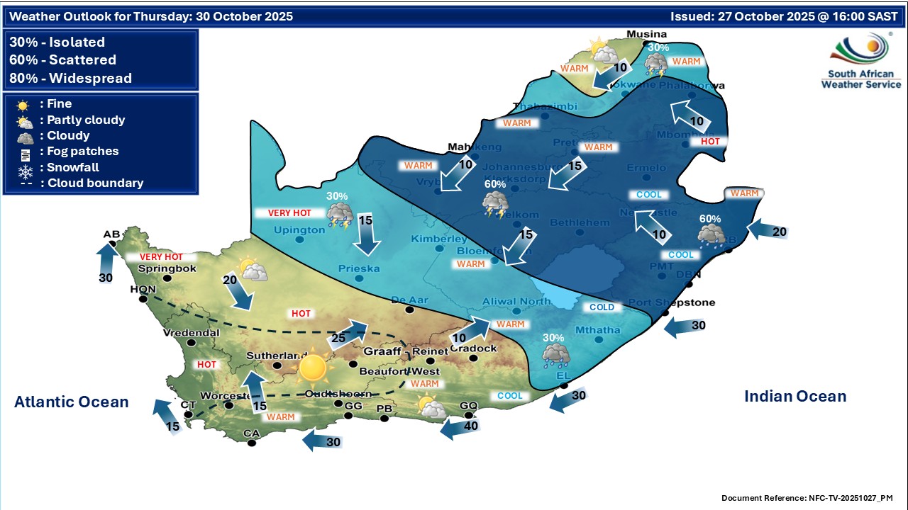
    Maps for Thursday 30 October

|