
  Swipe left or right for more maps, and see below for others
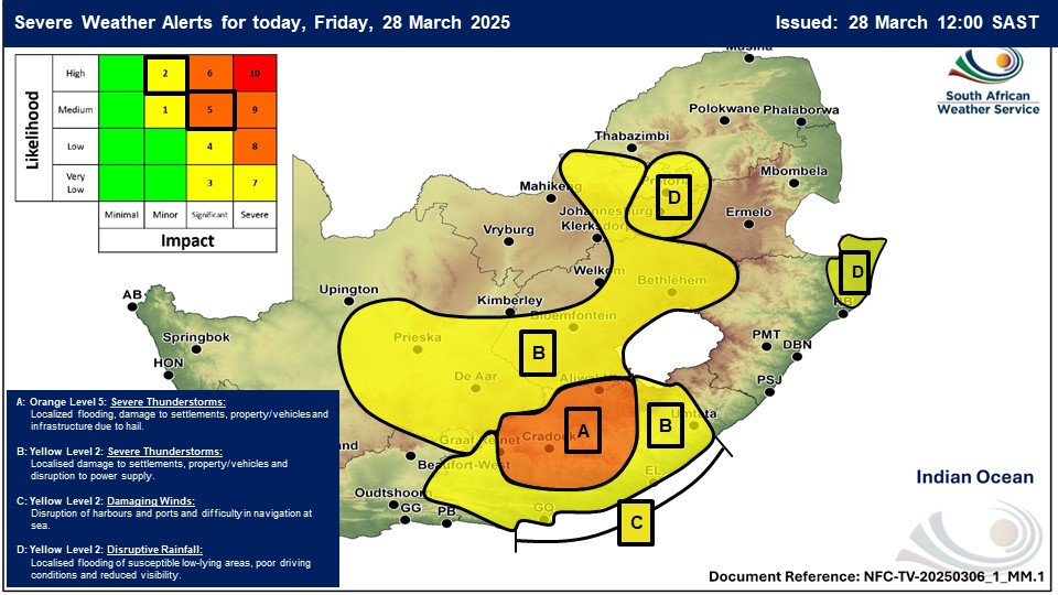
Severe thunderstorms, disruptive rain and damaging winds as an orange level 5 warning is issued for FridayBy Staff WriterPublished: 27 March 2025 [updated 28 March] This forecast is for: Fri 28 March 2025 The maps cover: Fri 28 Mar – Sun 30 Mar
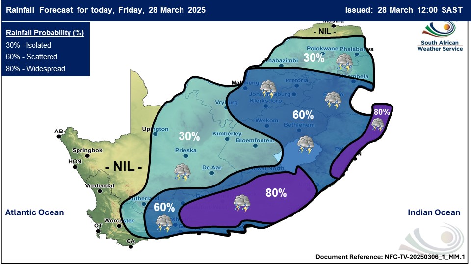
A newer forecast is available by clicking here. Scattered to widespread showers and thundershowers are expected over the eastern parts of the country with possible severe thunderstorms and disruptive rain in places in the Eastern Cape, Gauteng, Mpumalanga, North West and KwaZulu-Natal according to SA Weather. An intense cut-off low is expected to move across the Eastern Cape on Friday. Warnings from the SA Weather Service for Friday: A. orange level 5 warning severe thunderstorms leading to flooding, damage to settlements, property / vehicles and infrastructure are expected in places over the central and northern interior of Eastern Cape. B. yellow level 2 warning severe thunderstorms leading to localised damage to settlements, property / vehicles and disruption to power supply are expected in parts of the Eastern Cape, Northern Cape, Free State and North West. C. yellow level 2 warning damaging winds leading to localised damage to settlements / property / vehicles, disruption of harbours and ports and difficulty in navigation at sea are expected in places along the coast between Oyster Bay and Coffee Bay, as well as over Kouga local municipality and Nelson Mandela Bay Metro of Eastern Cape. D. yellow level 2 warning disruptive rainfall leading to localised damage to settlements, property / vehicles and disruption to power supply are expected in parts of the North West, Gauteng, Mpumalanga, Limpopo and KwaZulu-Natal. Extremely high fire danger conditions are expected in the Khai-Ma and Hantam municipalities of the Northern Cape. Regional forecasts from SAWS for Friday: 1. GAUTENG Cloudy and cool to warm with widespread showers and thundershowers. The expected UVB sunburn index: Moderate 2. MPUMALANGA Morning fog patches along the escarpment, otherwise cloudy and cool to warm with widespread showers and thundershowers but isolated to scattered in the Lowveld and along the escarpment where it will become partly cloudy in the afternoon. 3. LIMPOPO Morning fog patches and drizzle along the escarpment, otherwise cloudy and warm with isolated showers and thundershowers except in the extreme north. It will become partly cloudy in the east in the afternoon. 4. NORTH-WEST PROVINCE Morning fog patches over the eastern parts at first, otherwise cloudy and cool to warm, with scattered to widespread showers and thundershowers but isolated over the western parts where it will be partly cloudy. 5. FREE STATE Cloudy in the east and extreme south, otherwise partly cloudy and cool to warm, with scattered to widespread showers and thundershowers, but isolated over the central and the western parts. 6. NORTHERN CAPE Morning fog along the coast, otherwise fine and warm to hot but partly cloudy with isolated showers and thundershowers in the central and the eastern parts. The wind along the coast will be moderate southerly becoming westerly to north-westerly in the afternoon. 7. WESTERN CAPE Morning fog along the west coast, otherwise fine and warm but partly cloudy over the east and central parts with isolated showers and thundershowers. Evening fog is expected over the west and south-western parts. The wind along the coast will be strong easterly along the south coast including areas east of Cape Point, but moderate southerly to south-westerly in the west where it will become west to north-westerly from early afternoon. The expected UVB sunburn index: Very High 8. WESTERN HALF OF THE EASTERN CAPE Morning fog in places in the south, otherwise partly cloudy and cool to warm with widespread showers and thundershowers but scattered along the coast and adjacent interior west of Port Alfred. The wind along the coast will be moderate to fresh north-easterly, reaching strong east of Oyster Bay. 9. EASTERN HALF OF THE EASTERN CAPE Morning fog in places, otherwise cloudy and cool to warm with widespread showers and thundershowers but scattered in the extreme east. The wind along the coast will be light to moderate north-easterly, becoming fresh to strong from mid-morning. 10. KWAZULU-NATAL Morning fog patches over the interior, otherwise cloudy and cool to warm with scattered showers and thundershowers, but widespread in the north-east. The wind along the coast will be moderate to fresh easterly to north-easterly. The expected UVB sunburn index: Moderate Travellers forecasts from SAWS for Friday: PRETORIA Cloudy with widespread showers and thundershowers. Minimum/Maximum: 15/22°C The expected UVB Sunburn Index: Moderate JOHANNESBURG Cloudy with widespread showers and thundershowers. Minimum/Maximum: 13/20°C VEREENIGING Cloudy with widespread showers and thundershowers. Minimum/Maximum: 13/22°C MBOMBELA Morning fog patches, otherwise cloudy with scattered showers and thundershowers. Minimum/Maximum: 18/26°C POLOKWANE Cloudy with isolated showers and thundershowers. Minimum/Maximum: 17/24°C MAHIKENG Cloudy with widespread showers and thundershowers. Minimum/Maximum: 17/24°C VRYBURG Partly cloudy with isolated showers and thundershowers. Minimum/Maximum: 17/25°C BLOEMFONTEIN Partly cloudy with isolated showers and thundershowers. Minimum/Maximum: 15/26°C KIMBERLEY Partly cloudy with isolated showers and thundershowers. Minimum/Maximum: 17/29°C UPINGTON Partly cloudy. Minimum/Maximum: 21/33°C CAPE TOWN Fine with evening fog. Wind: Moderate south-easterly becoming light north-westerly in the afternoon. Minimum/Maximum: 18/28°C The expected UVB Sunburn Index: Very High GEORGE Partly cloudy with isolated showers and thundershowers. Wind: Light northerly to north-easterly becoming south-easterly in the afternoon. Minimum/Maximum: 13/26°C GQEBERHA Cloudy with scattered showers and thundershowers. Wind: Fresh to strong north-easterly. Minimum/Maximum: 17/24°C EAST LONDON Cloudy with widespread showers and thundershowers. Wind: Fresh to strong north-easterly. Minimum/Maximum: 18/24°C DURBAN Cloudy with scattered showers and thundershowers. Wind: Light north-westerly at first, otherwise moderate to fresh northerly to north-easterly. Minimum/Maximum: 19/26°C The expected UVB Sunburn Index: Moderate RICHARDS BAY Cloudy with scattered showers and thundershowers. Wind: Light and variable at first, otherwise moderate easterly to north-easterly. Minimum/Maximum: 20/26°C PIETERMARITZBURG Morning fog, otherwise cloudy with scattered showers and thundershowers. Minimum/Maximum: 15/24°C This forecast is usually updated a few times per day.
Please be sure to send photos and videos to us via whatsapp and also tell us where and when they were taken. Follow our channels
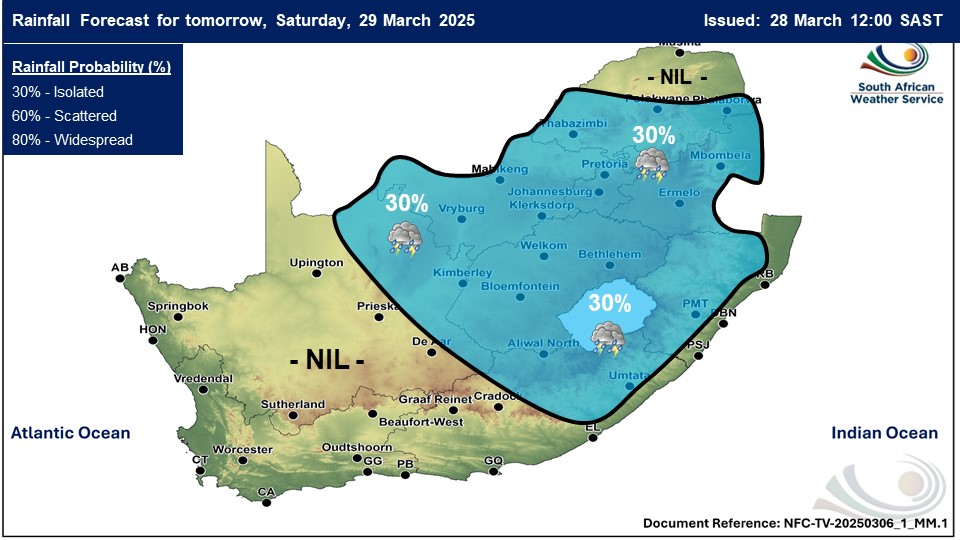
Maps for Saturday 29 March
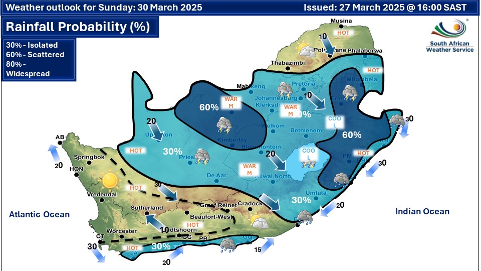
 Maps for Sunday 30 March
|