
 More maps below the forecast
Flooding likely as cut-off low comes with eight weather warnings from SAWS26 October 2024 [updated 27 October]By Staff Writer
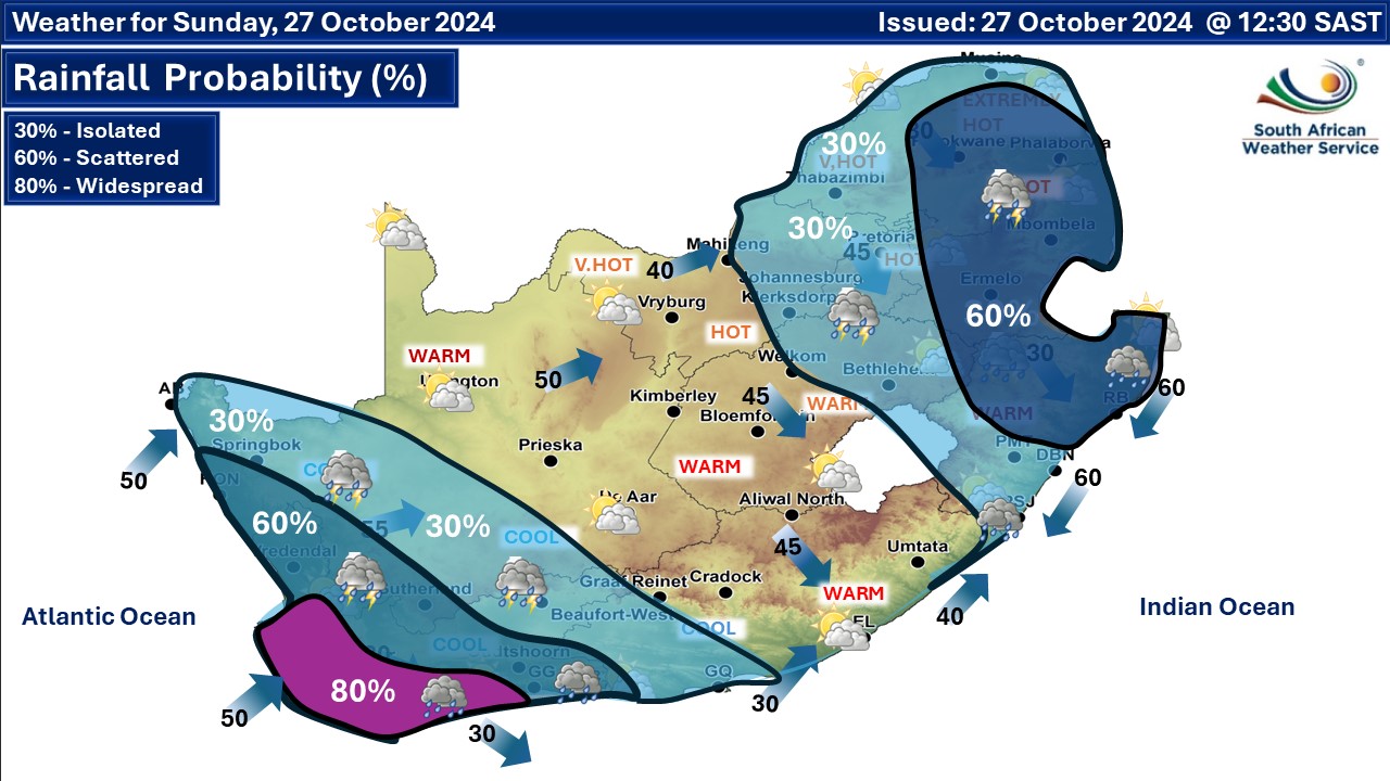
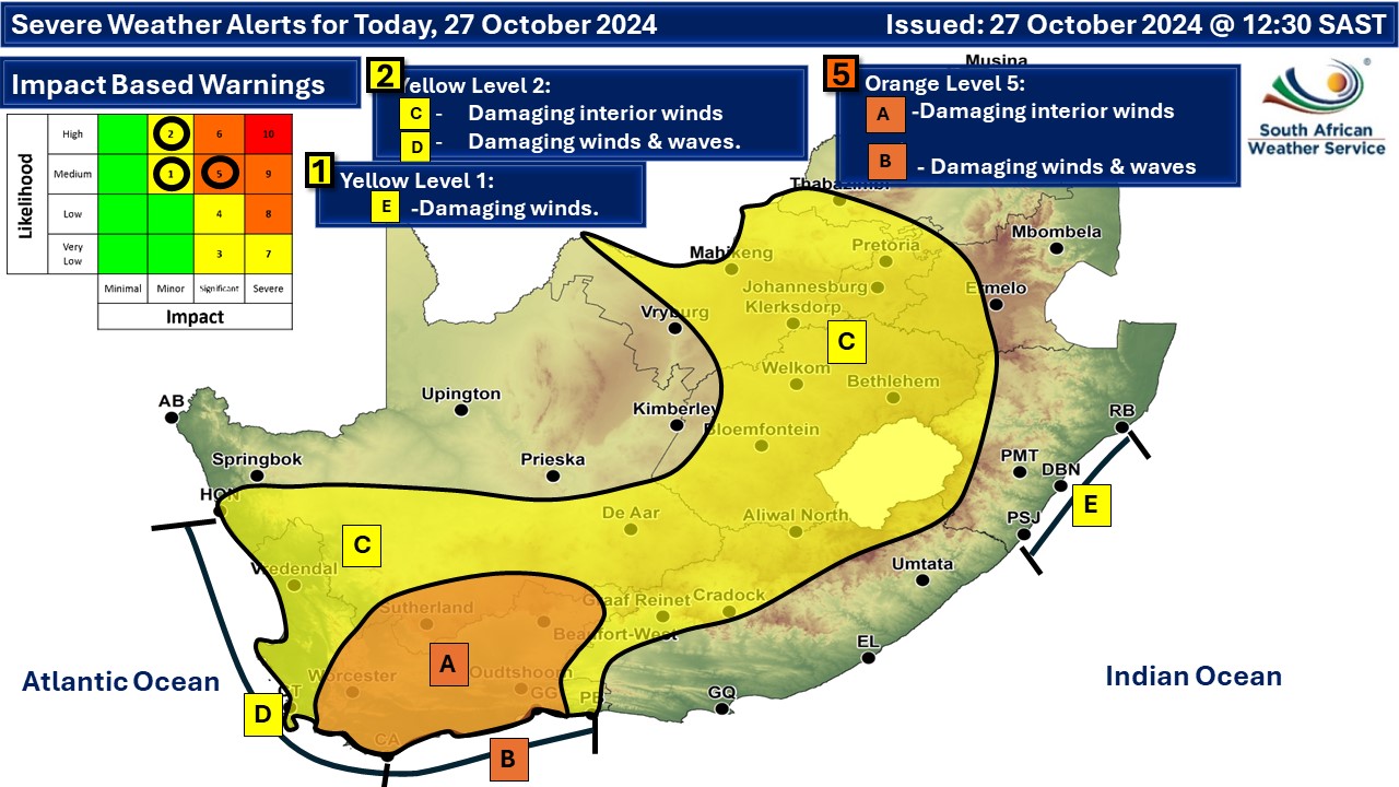
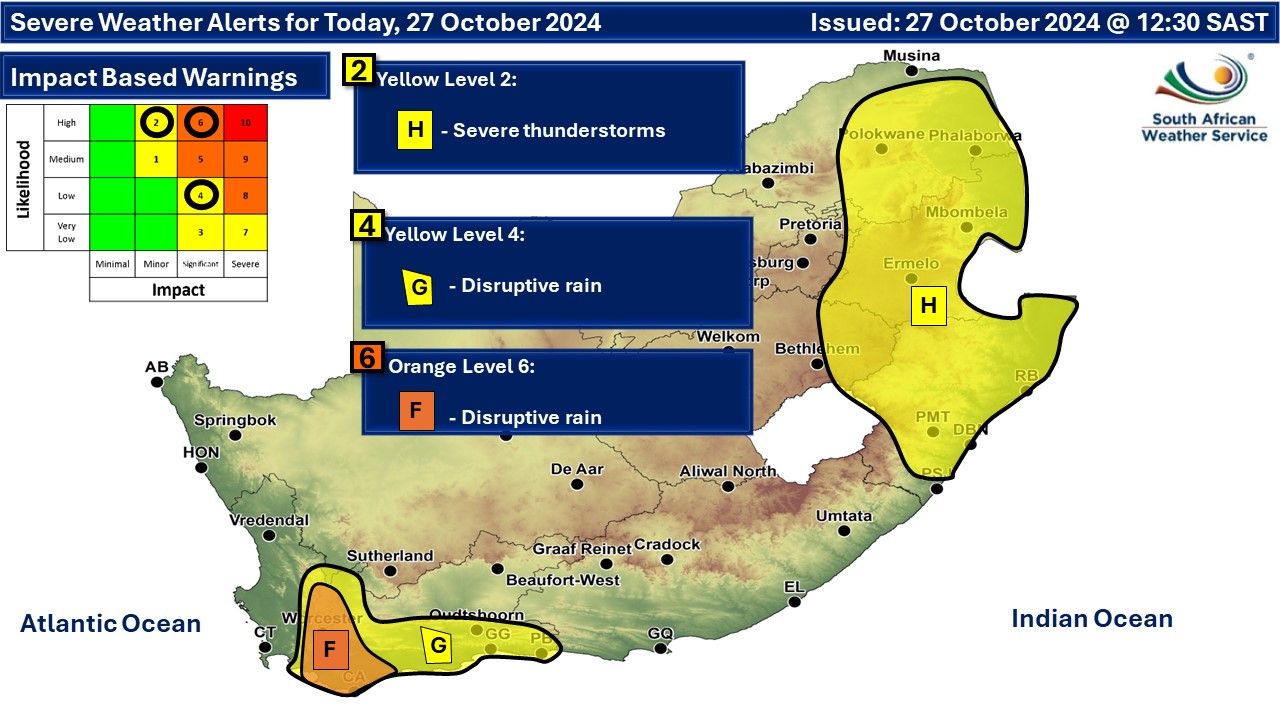
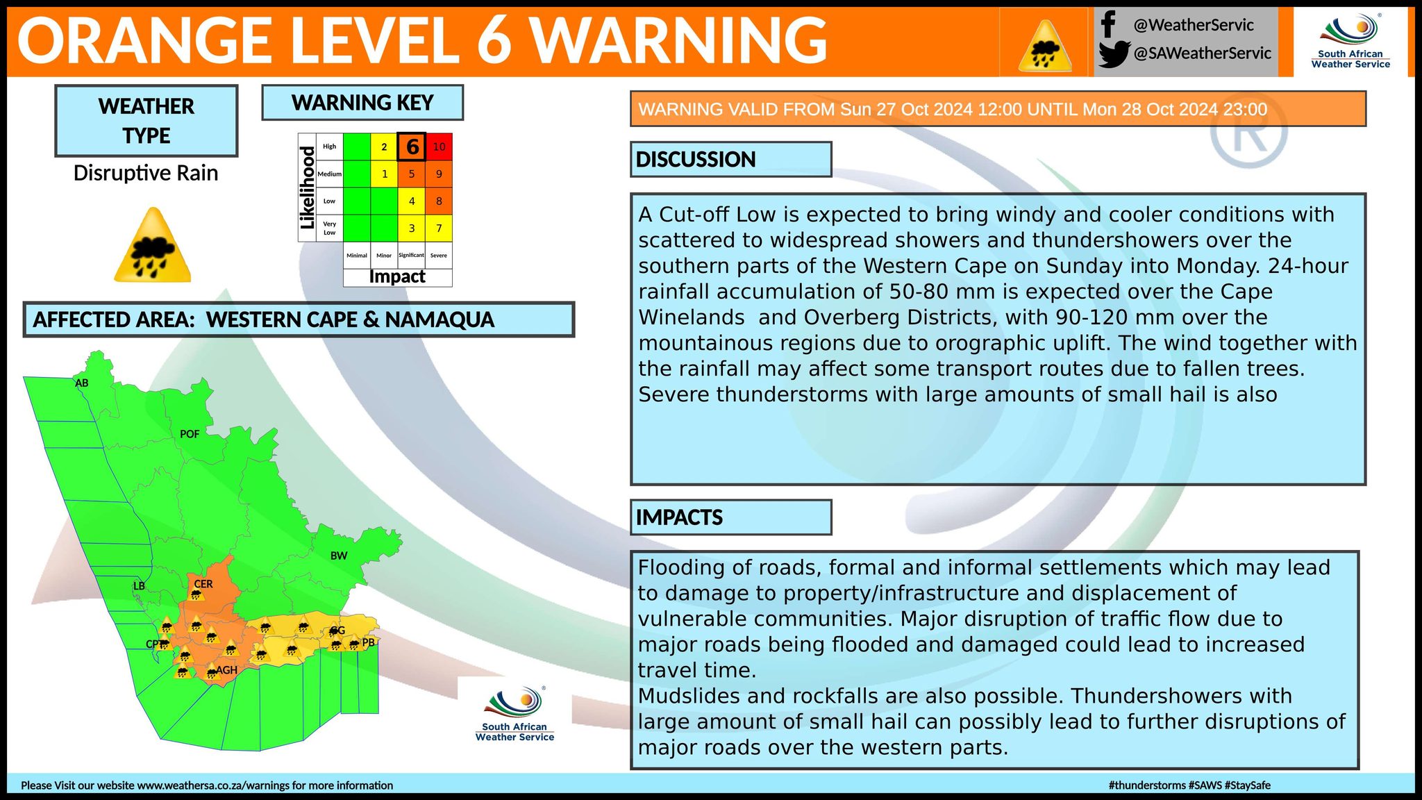
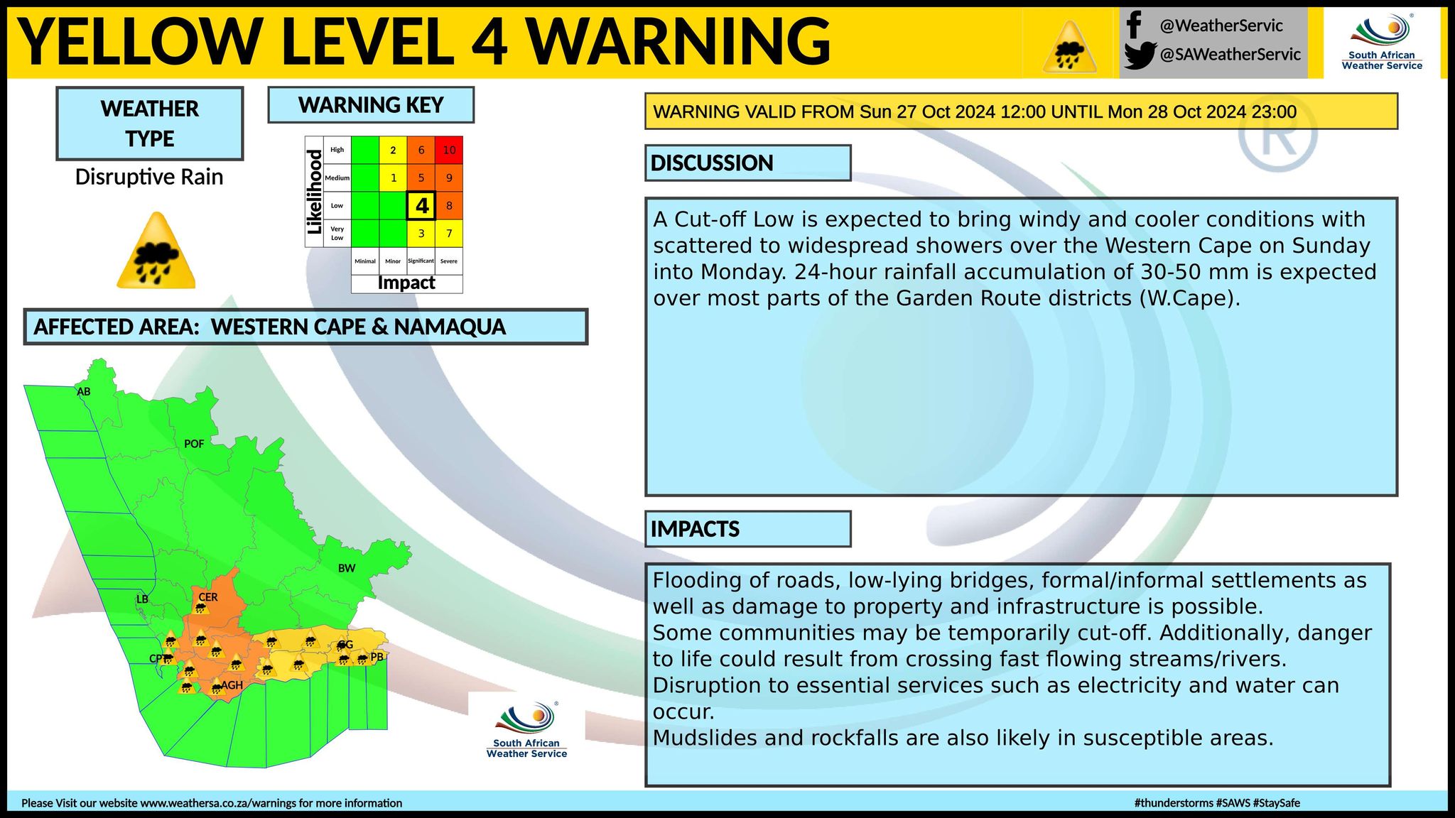
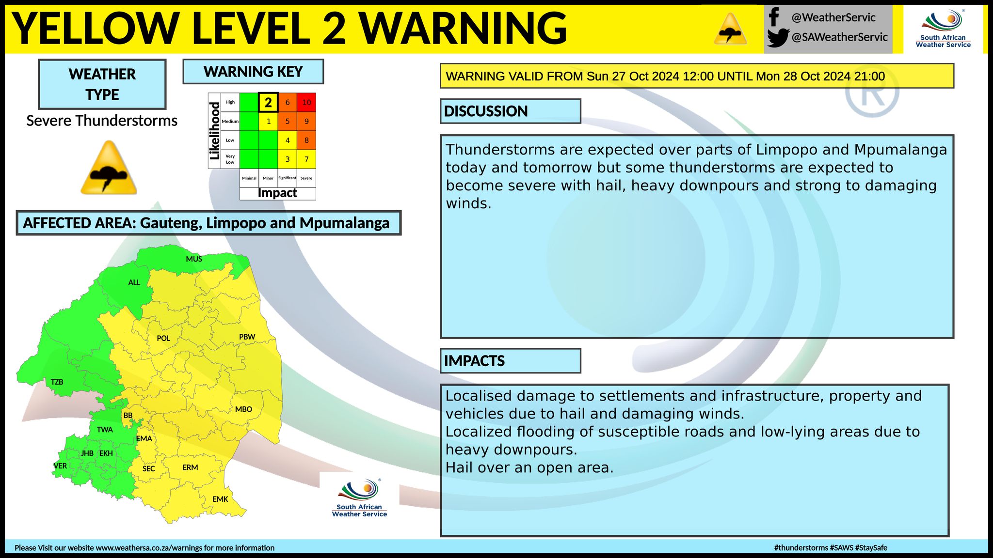
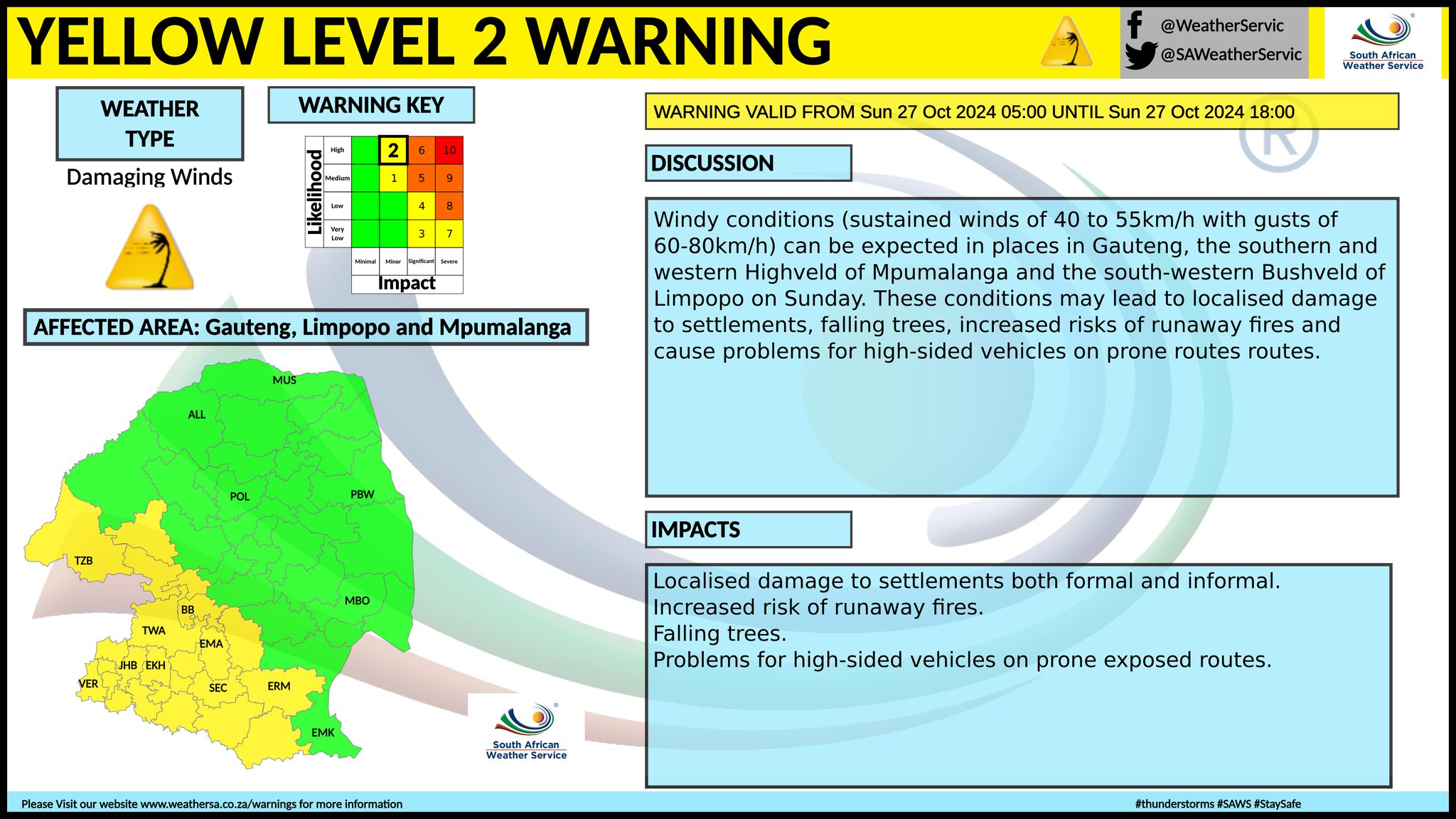
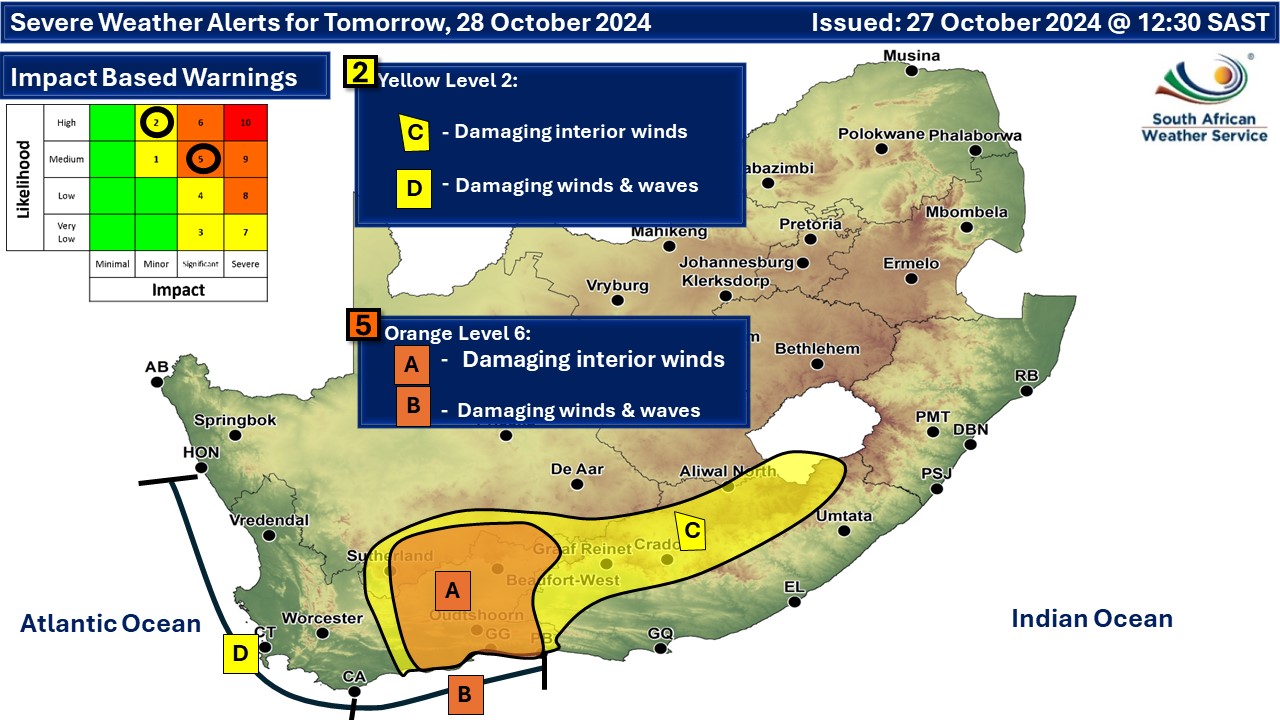
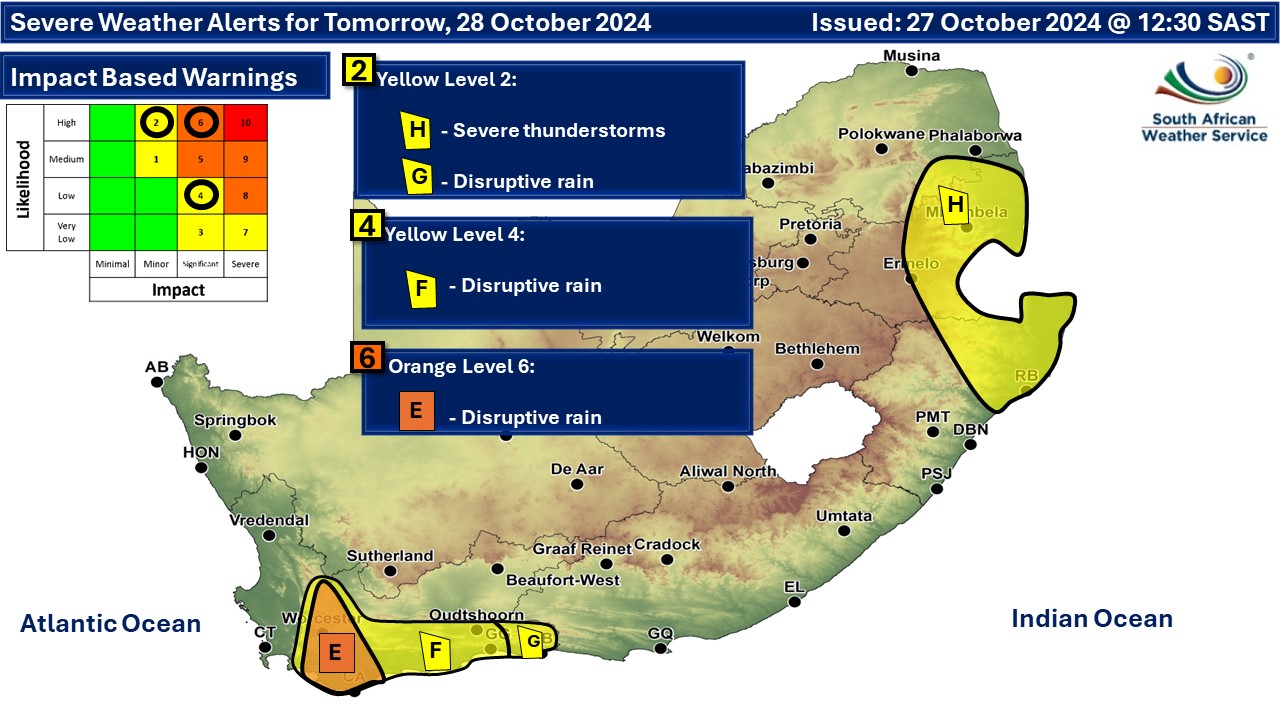
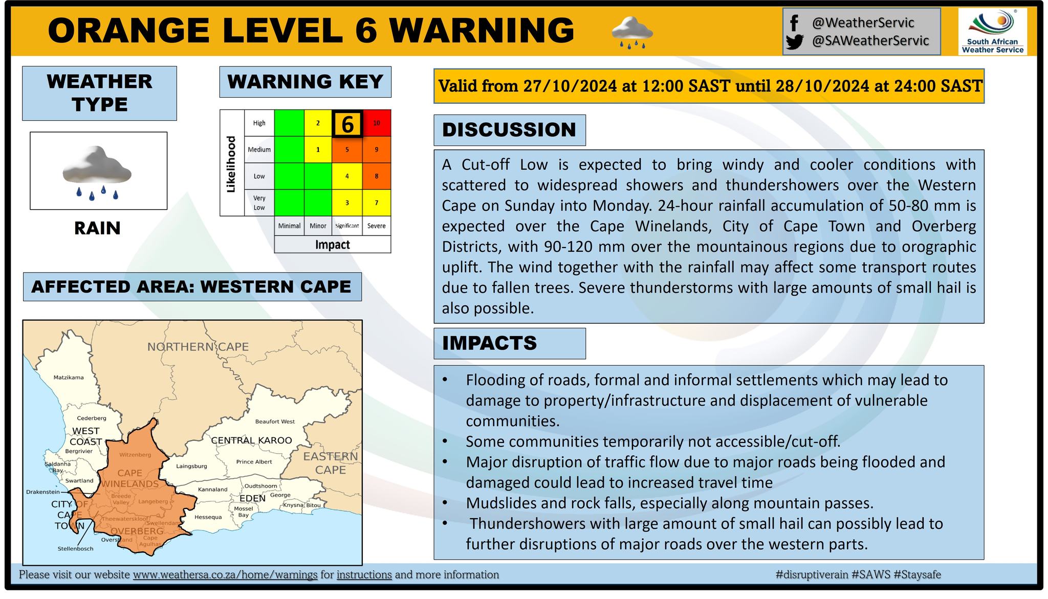
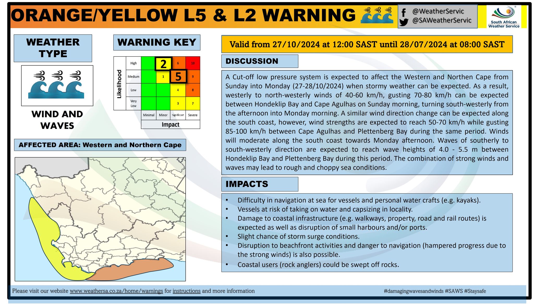
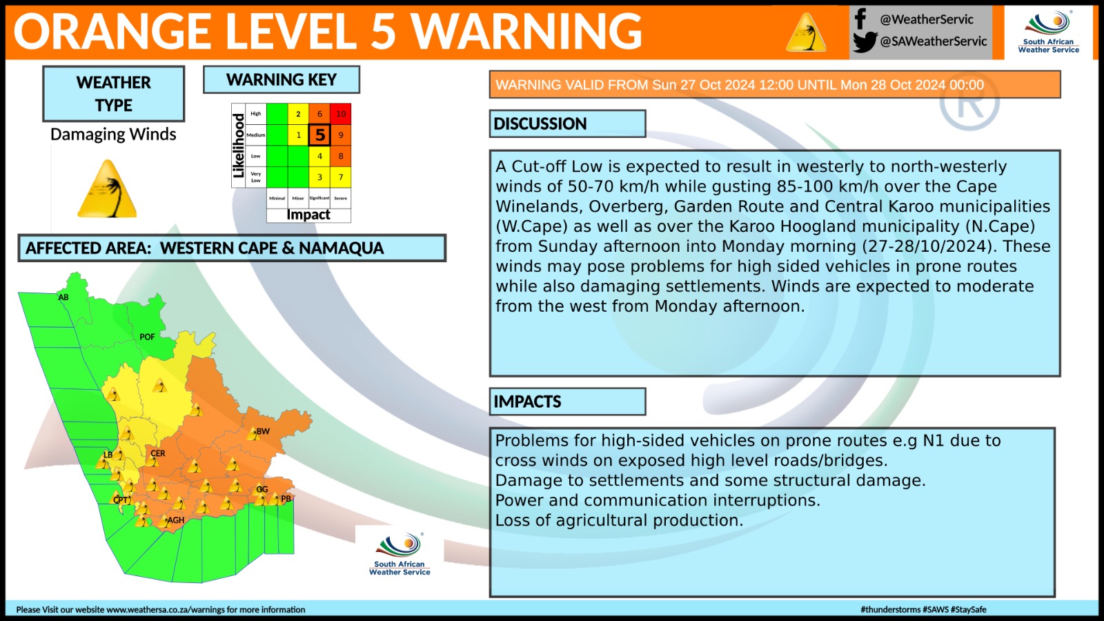
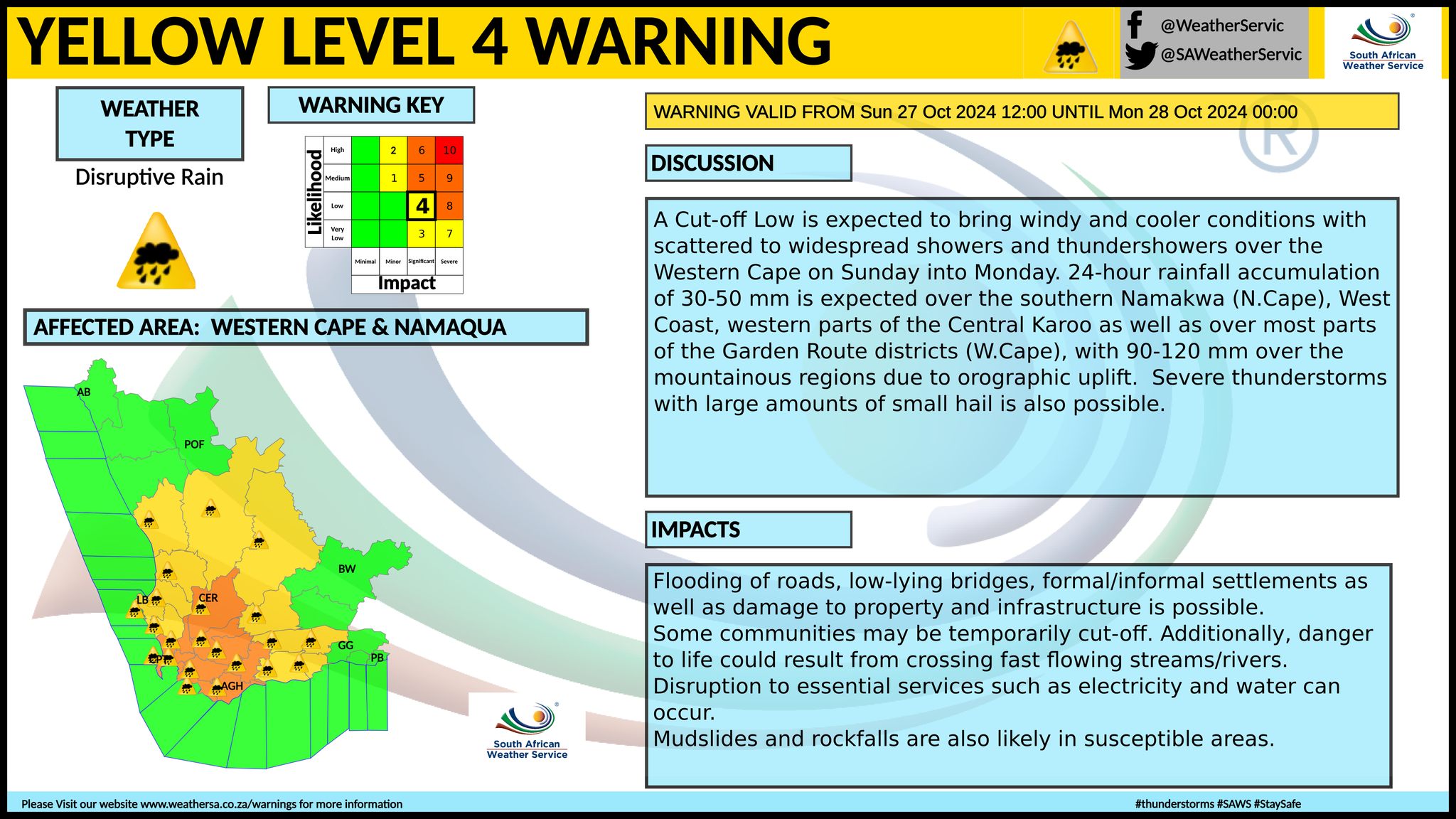
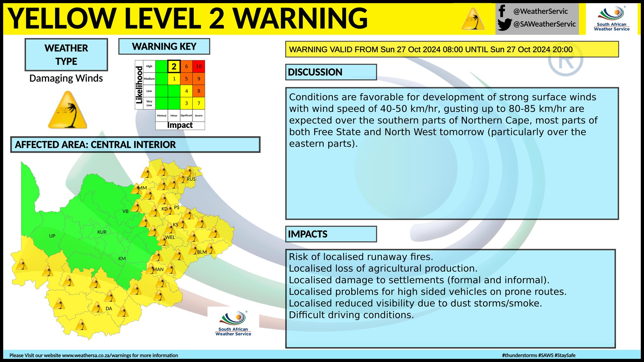
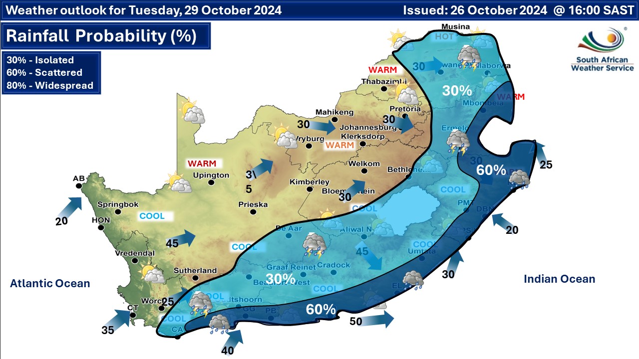
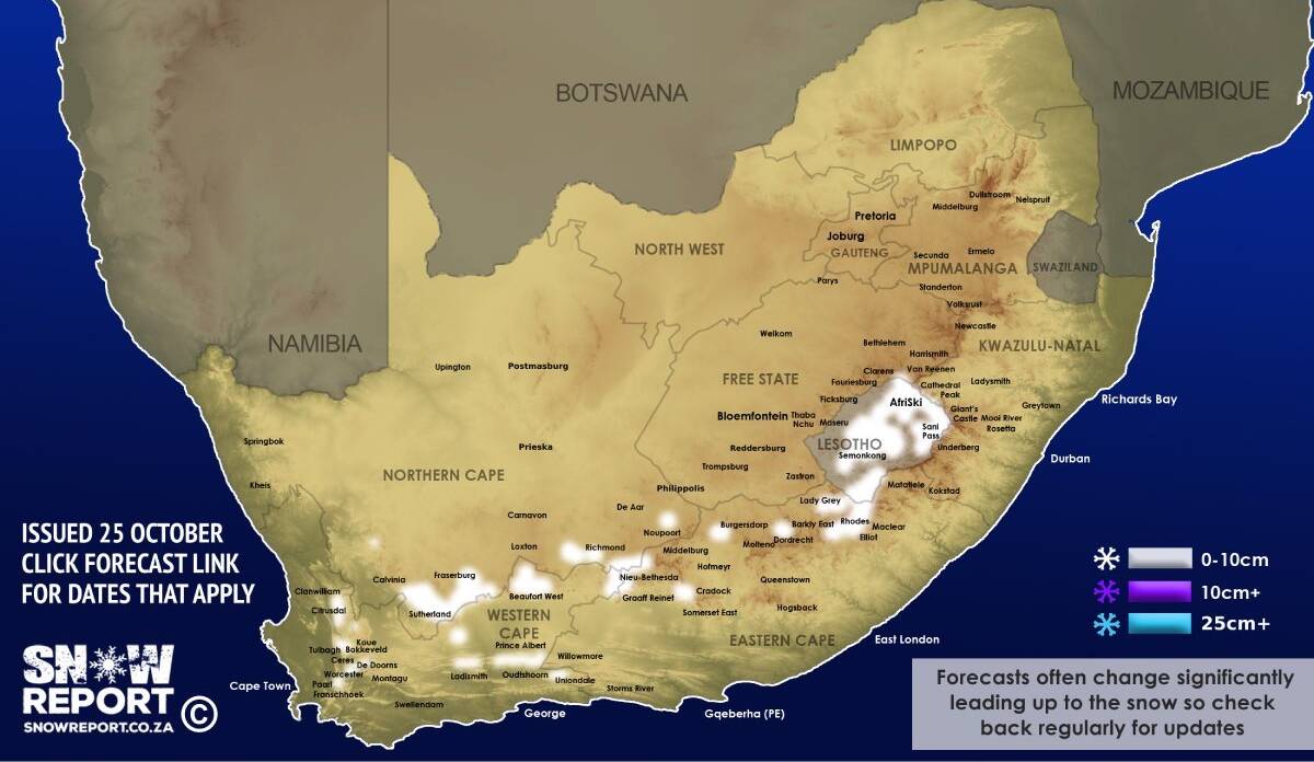
A newer forecast is available by clicking here. A well-defined upper-air system (cut-off low) is expected to pass over the western parts of the country on Saturday, propagating eastwards and eventually exiting South Africa on Tuesday. This weather system is expected to be accompanied by strong to near gale force winds (55-65km/h) over the Cape provinces, but fresh to strong (30-50km/h) over North West, Gauteng, the Free State and western parts of KwaZulu-Natal on Sunday, ceasing by Monday. Scattered to widespread showers and thundershowers can be expected over the western parts of the country, while spreading over the central and eastern parts on Sunday and Monday but are expected to cease from the west by Tuesday. Heavy downpours with rainfall accumulations exceeding 60 mm can be expected in the south-west parts of the country on Sunday, while it will advance along the south coast of the Western Cape and adjacent interior on Monday. This can be coupled with flooding of roads and settlements, damage or loss of infrastructure, property, vehicles, livelihoods and livestock, with the possibility hail. 24-hour rainfall accumulation of 50-80mm is expected over the Cape Winelands, City of Cape Town and Overberg Districts, with 90-120mm over the mountainous regions due to orographic uplift. See maps below for more regional rainfall details. Along the coastal regions strong winds, coupled with very rough seas with wave heights of 4-5m can be expected from Saturday, reaching 5-6m along the extreme south-western coastline by Monday. The waves are expected to subside on Tuesday. A significant drop in temperatures can be expected from the west on Sunday, spreading to the central part of the country by Monday. Some snowfall is possible in three South African provinces and in Lesotho from this weekend. We have posted a separate snow forecast for it but the map is also available below. ALSO READ: More snowfall possible as another cut-off low causes temperatures to drop from this weekend. Warnings from the SA Weather Service (SAWS) for Sunday and Monday: A. orange level 5 warning for damaging winds leading to difficult Driving conditions and damage to settlements is expected over the Cape Winelands, Overberg, Garden Route and Central Karoo municipalities of the Western Cape and the Karoo Hoogland municipality of the Northern Cape. B. orange level 5 warning for damaging waves and winds leading to disruptions to ports and harbours are expected between Cape Agulhas and Plettenberg Bay. C. yellow level 2 warning for damaging winds leading to localised Damage to settlements, travel disruptions as well as reduced visibility are expected over the southern parts of the Northern Cape, the extreme western parts of the Western Cape, the northern interior of the Eastern Cape, the Free State, North West, Gauteng, the southern and western Highveld of Mpumalanga, the south-western Bushveld of Limpopo and the extreme western interior of KwaZulu-Natal. D. yellow level 2 warning for damaging winds and waves leading to localised disruptions to ports and small harbours are expected between Hondeklip Bay and Cape Agulhas. E. yellow level 1 warning for damaging winds resulting in some transport routes and travel services affected by fallen trees with localised disruptions of harbours and/or ports for a period of time are expected along the coast between Plettenberg Bay and Richards Bay. F. orange level 6 warning for disruptive rain leading to flooding of roads and settlements as well as damage to infrastructure is expected over the Cape Winelands, City of Cape Town and Overberg Districts of the Western Cape. G. yellow level 4 warning for disruptive rain leading to flooding of roads and settlements is expected over the southern Namakwa District of the Northern Cape, the West Coast, western parts of the Central Karoo as well as the Garden Route Districts of the Western Cape. H. yellow level 2 warning for severe thunderstorms leading to hail, damaging winds and heavy downpours are expected over the eastern parts of the Free State, most parts of KwaZulu-Natal, the Highveld and escarpment of Mpumalanga and the central and southern parts of Limpopo. Regional forecasts from SAWS for Sunday: 1. GAUTENG Partly cloudy, windy and warm to hot with isolated showers and thundershowers from early afternoon. The expected UVB sunburn index: Very high 2. MPUMALANGA Cloudy in the east in the morning with fog patches along the escarpment, otherwise partly cloudy and cool to warm with scattered showers and thundershowers. It will be windy in places on the Highveld. 3. LIMPOPO Cloudy in the east in the morning with fog patches along the escarpment, otherwise partly cloudy and hot to very hot with isolated showers and thundershowers but scattered over the central and southern parts. It will be windy in the south-western Bushveld. 4. NORTH-WEST PROVINCE Partly cloudy, windy and warm with isolated showers and thundershowers in the east from the afternoon where it will be hot. 5. FREE STATE Partly cloudy, windy and cool to warm with isolated showers and thundershowers in the east from the afternoon. It will be hot in the north. 6. NORTHERN CAPE Partly cloudy in the east and north, otherwise cloudy, windy and cool to cold with isolated showers and thundershowers but scattered in the south-west where it will be very cold. Light snow is expected over the south-western high-lying areas. The wind along the coast will be fresh to strong westerly to north-westerly, moderating in the evening. 7. WESTERN CAPE Partly cloudy in the eastern parts in the morning, otherwise cloudy, windy and cool to cold with isolated to scattered showers and thundershowers but widespread over the western and south-western parts. The wind along the coast will be strong to gale force westerly to south-westerly but westerly to north-westerly along the south coast. The expected UVB sunburn index: Low 8. WESTERN HALF OF THE EASTERN CAPE Fine, windy and cool, becoming cloudy from the afternoon with isolated showers and thundershowers over the western and southern parts, but scattered in the south-west. The wind along the coast will be fresh to strong south-westerly, becoming light by the afternoon. 9. EASTERN HALF OF THE EASTERN CAPE Morning fog patches along the escarpment in the morning, otherwise partly cloudy, windy and warm but cool along the coast. The wind along the coast will be moderate to fresh north-easterly in the morning, otherwise fresh to strong south-westerly. 10. KWAZULU-NATAL Morning fog patches over the interior, otherwise partly cloudy and warm to hot with scattered showers and thundershowers from the afternoon. It will be windy in the extreme west. The wind along the coast will be strong north-easterly, becoming moderate to fresh south-westerly in the south in the evening. The expected UVB sunburn index: High Travellers forecasts from SAWS for Sunday: PRETORIA Partly cloudy and windy with isolated showers and thundershowers from early afternoon. Minimum/Maximum: 18/33°C The expected UVB Sunburn Index: Very high JOHANNESBURG Partly cloudy and windy with isolated showers and thundershowers from early afternoon. Minimum/Maximum: 16/31°C VEREENIGING Partly cloudy and windy with isolated showers and thundershowers from early afternoon. Minimum/Maximum: 17/32°C MBOMBELA Cloudy in the morning with fog patches, otherwise partly cloudy with scattered showers and thundershowers from the afternoon. Minimum/Maximum: 16/31°C POLOKWANE Cloudy in the morning, otherwise partly cloudy with scattered showers and thundershowers from the afternoon. Minimum/Maximum: 17/33°C MAHIKENG Partly cloudy and windy. Minimum/Maximum: 20/31°C VRYBURG Partly cloudy and windy. Minimum/Maximum: 14/26°C BLOEMFONTEIN Partly cloudy and windy. Minimum/Maximum: 13/23°C KIMBERLEY Partly cloudy and windy. Minimum/Maximum: 13/22°C UPINGTON Cloudy in the morning, otherwise partly cloudy and windy. Minimum/Maximum: 12/18°C CAPE TOWN Cloudy and windy with widespread showers. Wind: Moderate to fresh north-westerly in the morning, otherwise strong westerly to south-westerly. Minimum/Maximum: 13/18°C The expected UVB Sunburn Index: Low GEORGE Fine at first, otherwise cloudy and windy with scattered showers and thundershowers. Wind: Strong north-westerly to westerly reaching gale force in the evening. Minimum/Maximum: 12/20°C GQEBERHA Fine, becoming cloudy from the afternoon with isolated showers in the evening. Wind: Fresh to strong south-westerly, becoming light by the afternoon. Minimum/Maximum: 15/22°C EAST LONDON Cloudy in the morning, otherwise partly cloudy. Wind: Moderate to fresh north-easterly in the morning, otherwise fresh to strong south-westerly. Minimum/Maximum: 16/23°C DURBAN Partly cloudy with scattered showers and thundershowers from the afternoon. Wind: Strong north-easterly, becoming fresh to strong south-westerly in the evening. Minimum/Maximum: 18/29°C The expected UVB Sunburn Index: High RICHARDS BAY Partly cloudy with scattered showers and thundershowers from the afternoon. Wind: Strong north-easterly. Minimum/Maximum: 19/30°C PIETERMARITZBURG Morning fog patches, otherwise partly cloudy with scattered showers and thundershowers from the afternoon. Minimum/Maximum: 14/32°C This forecast may change and updates issued more than once a day. Please be sure to send photos and videos to us via whatsapp and also tell us where and when they were taken. See below for a link to our whatsapp channel but since the link does not work in the instagram app you will need to send us a whatsapp message and we'll send you a link. Follow our channels
Standard users are welcome to use the standard sharing buttons on this page to share our content. It is NOT acceptable to download or screen grab for reposting. Other media and channels need to send us a request in order to embed or use of our forecasts, maps, as well as images and video from our users that we post (before doing so).
Issued on Sunday
         Issued on Saturday
      Issued on Friday
 |