
   Swipe left or right for more maps, and see below for others
Severe thunderstorms or disruptive rain expected in six provinces on ThursdayBy Staff WriterPublished: 26 March 2025 [updated 27 March] This forecast is for: Thu 27 March 2025 The maps cover: Thu 27 Mar – Sat 29 Mar
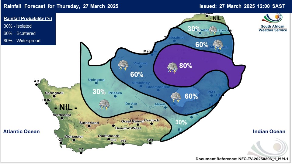
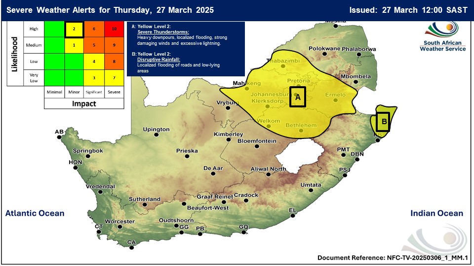
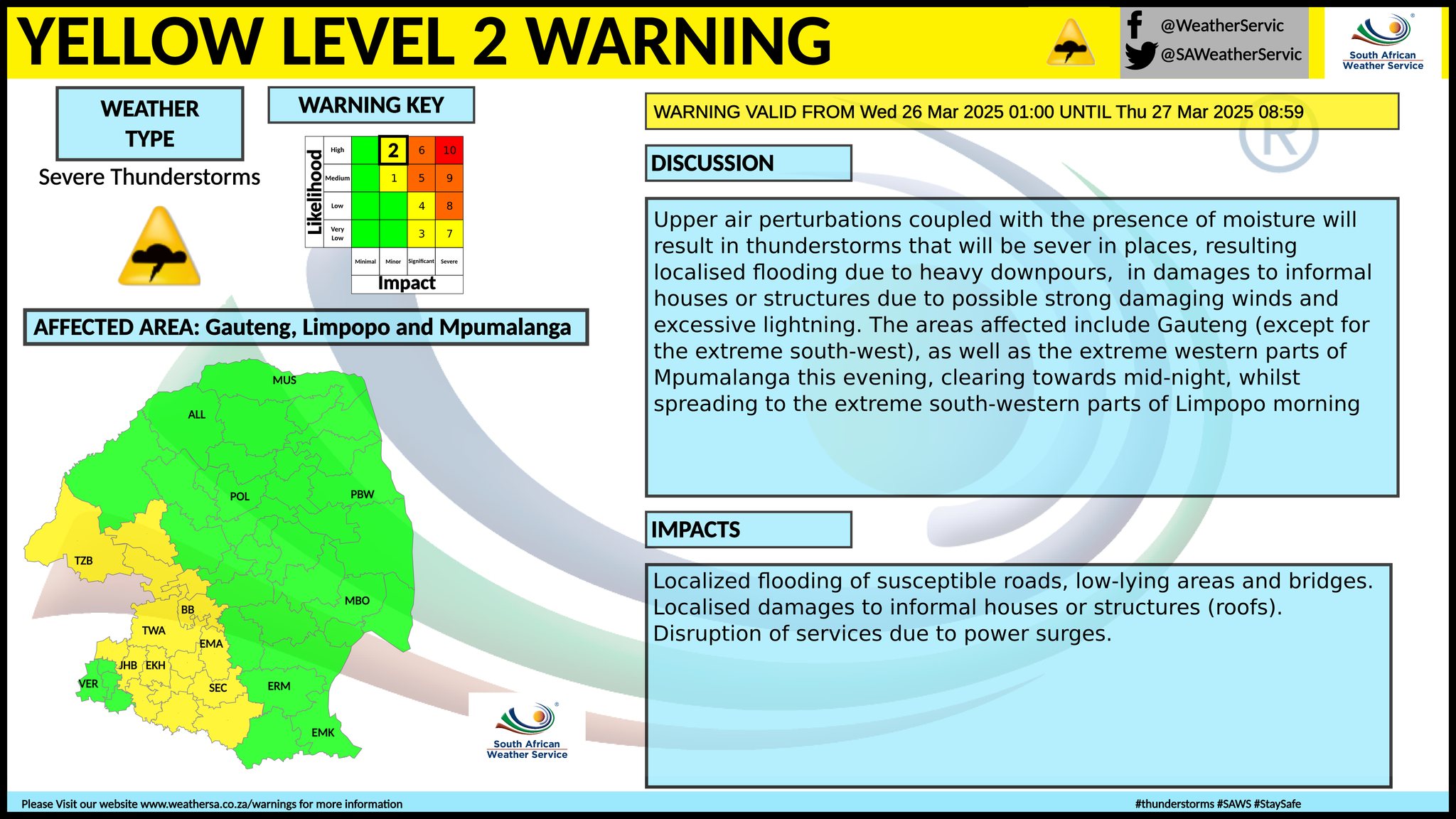
A newer forecast is available by clicking here. Isolated to scattered showers and thundershowers over the central and eastern parts, spreading to the western interior on Friday, but widespread in places over the central parts on Thursday according to SA Weather. An intense cut-off low is expected to move across the Eastern Cape on Friday. The public are advised that this can result in a possibility of severe storms associated with heavy downpours, large hail and strong winds. Warnings from the SA Weather Service for Thursday: A. yellow level 2 warning severe thunderstorms with heavy downpours are expected to result in localised flooding of low-lying areas and bridges as well as susceptible areas over Gauteng, South-Western Bushveld in Limpopo, Highveld of Mpumalanga and the eastern parts of both the Free State and North West. B. yellow level 2 warning disruptive rain leading to localised flooding of roads, low lying bridges and settlements is expected over the north-eastern parts of KwaZulu Natal. Extremely high fire danger conditions are expected in the Hantam Municipality in the Northern Cape. Regional forecasts from SAWS for Thursday: 1. GAUTENG Cloudy and cool to warm with widespread showers and thundershowers. The expected UVB sunburn index: Low 2. MPUMALANGA Cloudy and cool to warm with widespread showers and thundershowers but scattered in the north-east. 3. LIMPOPO Cloudy and warm with isolated showers and thundershowers except over the Limpopo Valley where it will be partly cloudy, but scattered over the southern parts. 4. NORTH-WEST PROVINCE Partly cloudy and warm with scattered showers and thundershowers but cloudy with widespread in the east. 5. FREE STATE Morning fog patches, otherwise partly cloudy and cool to warm with isolated to scattered showers and thundershowers, but cloudy with widespread in the east. 6. NORTHERN CAPE Morning fog patches along the coast, otherwise fine and warm to hot but partly cloudy with isolated to scattered showers and thundershowers in the east. It will be cool in places in the west. The wind along the coast will be moderate to fresh south-easterly, becoming light to moderate south-westerly from the afternoon. 7. WESTERN CAPE Partly cloudy along the south-western interior until the afternoon, otherwise fine and warm but cool in places along the south-east. The wind along the coast will be moderate to fresh easterly to south-easterly, becoming fresh south-westerly in the west from the afternoon. The expected UVB sunburn index: Low 8. WESTERN HALF OF THE EASTERN CAPE Morning fog patches over the interior, otherwise fine and cool to warm. The wind along the coast will be light westerly becoming moderate to fresh easterly in the afternoon. 9. EASTERN HALF OF THE EASTERN CAPE Morning fog patches over the interior, otherwise partly cloudy and cool with isolated showers and thundershowers but cloudy with scattered in the north-east. The wind along the coast will be light westerly, becoming easterly in the afternoon. 10. KWAZULU-NATAL Morning fog patches over the interior otherwise cloudy and cold to cool with scattered showers and thundershowers but widespread in the north-east where it will be warm. The wind along the coast will be moderate to fresh southerly to south-easterly The expected UVB sunburn index: Low Travellers forecasts from SAWS for Thursday: PRETORIA Cloudy with widespread showers and thundershowers. Minimum/Maximum: 18/25°C The expected UVB Sunburn Index: Low JOHANNESBURG Cloudy with widespread showers and thundershowers. Minimum/Maximum: 16/23°C VEREENIGING Cloudy with widespread showers and thundershowers. Minimum/Maximum: 16/24°C MBOMBELA Cloudy with scattered showers and thundershowers. Minimum/Maximum: 19/24°C POLOKWANE Cloudy with isolated showers and thundershowers. Minimum/Maximum: 17/25°C MAHIKENG Cloudy with widespread showers and thundershowers. Minimum/Maximum: 17/27°C VRYBURG Partly cloudy with scattered showers and thundershowers. Minimum/Maximum: 17/29°C BLOEMFONTEIN Morning fog patches, otherwise partly cloudy with scattered showers and thundershowers. Minimum/Maximum: 14/28°C KIMBERLEY Partly cloudy with scattered afternoon showers and thundershowers. Minimum/Maximum: 16/30°C UPINGTON Fine in the morning, otherwise partly cloudy with isolated showers and thundershowers. Minimum/Maximum: 19/34°C CAPE TOWN Fine. Wind: Light to moderate southerly to south-westerly in the morning, otherwise south-easterly, becoming light and variable in the evening. Minimum/Maximum: 16/27°C The expected UVB Sunburn Index: Low GEORGE Fine. Wind: Moderate south-easterly to easterly. Minimum/Maximum: 12/22°C GQEBERHA Fine, becoming cloudy in the evening. Wind: Light westerly becoming moderate to fresh easterly in the afternoon. Minimum/Maximum: 16/24°C EAST LONDON Fine, becoming cloudy with isolated showers and rain. Wind: Light westerly, becoming easterly in the afternoon. Minimum/Maximum: 17/23°C DURBAN Cloudy with scattered showers and thundershowers. Wind: Moderate to fresh southerly to south-easterly. Minimum/Maximum: 21/24°C The expected UVB Sunburn Index: Low RICHARDS BAY Cloudy with scattered showers and thundershowers. Wind: Moderate to fresh southerly to south-easterly. Minimum/Maximum: 22/24°C PIETERMARITZBURG Morning fog, otherwise cloudy with scattered showers and thundershowers. Minimum/Maximum: 16/20°C This forecast is usually updated a few times per day.
Please be sure to send photos and videos to us via whatsapp and also tell us where and when they were taken. Follow our channels
Maps for Friday 28 March
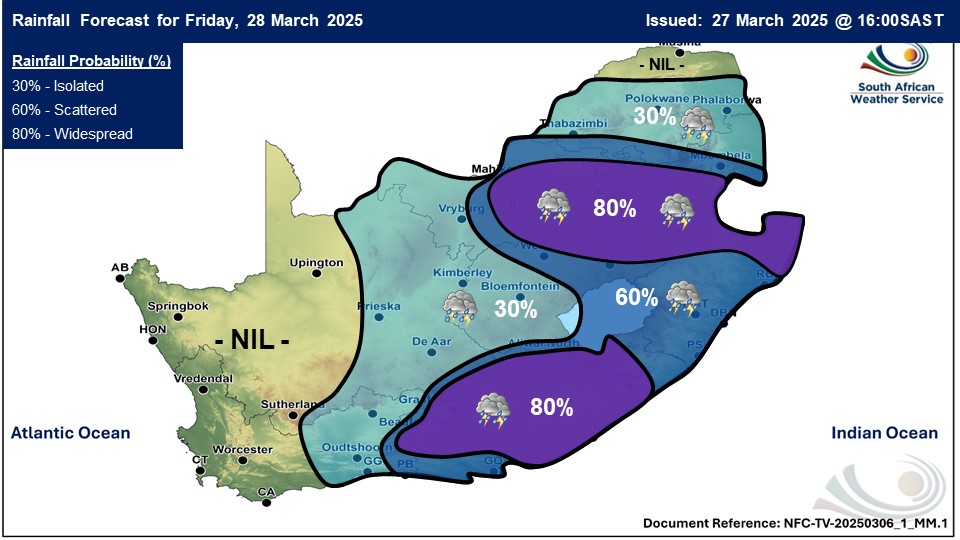 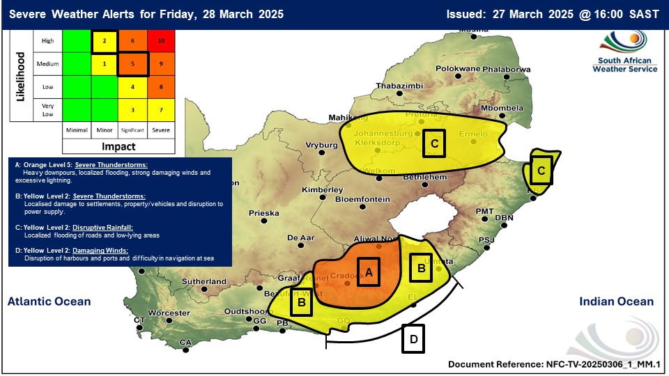 The date on the map above should be Friday 28 March 2025
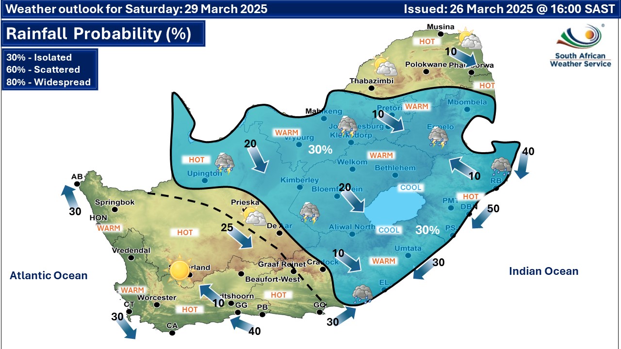
Maps for Saturday 29 March
|