
WEDNESDAY WEATHER: Rain possible in the south-west and the north-east as another cold front arrives
By Staff WriterPublished: 24 February 2026 [updated 25 February]
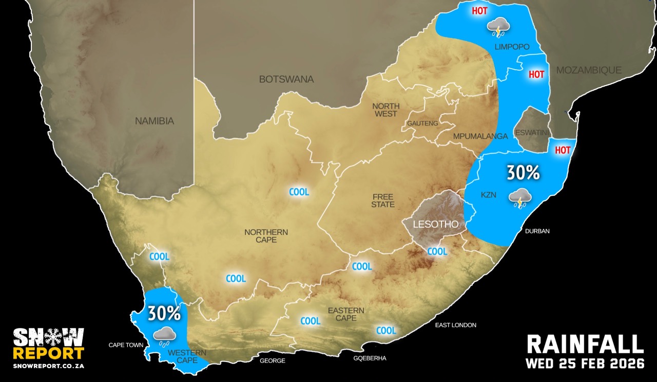
This forecast is for: Wed 25 February 2026
The maps cover: Wed 25 Feb – Wed 25 Feb
| SHARE TO |
The latest forecast is available by clicking here.
From Wednesday it should be partly cloudy and cool to warm, but hot in places with isolated showers and thundershowers in the north-east and light rain along the coast.
Warnings from the SA Weather Service for Wednesday:
No impact warnings for now.
Regional forecasts from the SA Weather Service for Wednesday:
GAUTENG
Morning fog patches in places, otherwise partly cloudy and warm.
MPUMALANGA
Partly cloudy and warm to hot with isolated showers and thundershowers in the eastern parts.
LIMPOPO
Partly cloudy and warm to hot with isolated showers and thundershowers over the north and eastern parts.
NORTH WEST
Morning fog over the extreme north-eastern parts, otherwise partly cloudy and cool to warm.
THE FREE STATE
Morning fog in places, otherwise partly cloudy and cool.
THE NORTHERN CAPE
Morning fog along the coast and in places in the south, otherwise partly cloudy and cool to warm, but fine in the north-west. The wind along the coast will be moderate north-westerly in the morning, otherwise westerly to south-westerly.
THE WESTERN CAPE
Morning fog along the west coast, otherwise partly cloudy and cool to warm but cloudy with a chance of light rain over the south-western parts. The wind along the coast will be moderate to fresh north-westerly to westerly becoming south-westerly in the afternoon.
THE WESTERN HALF OF THE EASTERN CAPE
Morning fog patches, otherwise, partly cloudy and cool to warm. The wind along the coast will be moderate to fresh south-westerly, becoming light to moderate westerly in the afternoon.
THE EASTERN HALF OF THE EASTERN CAPE
Partly cloudy and cool to warm. The wind along the coast will be moderate to fresh south-westerly.
KWAZULU-NATAL
Morning fog over the interior, otherwise partly cloudy and warm but cool in the extreme south-west. Isolated showers and thundershowers can be expected. The wind along the coast will be moderate to fresh southerly to south-westerly.
Travellers forecasts from the SA Weather Service for Wednesday:
PRETORIA
Morning fog patches in places, otherwise partly cloudy.
Minimum/Maximum: 16/29°C
JOHANNESBURG
Morning fog patches in places, otherwise partly cloudy.
Minimum/Maximum: 14/27°C
VEREENIGING
Partly cloudy.
Minimum/Maximum: 14/27°C
MBOMBELA
Partly cloudy with isolated showers and thundershowers.
Minimum/Maximum: 19/32°C
POLOKWANE
Partly cloudy.
Minimum/Maximum: 16/31°C
MAHIKENG
Partly cloudy.
Minimum/Maximum: 13/30°C
VRYBURG
Partly cloudy.
Minimum/Maximum: 13/29°C
BLOEMFONTEIN
Partly cloudy.
Minimum/Maximum: 15/27°C
KIMBERLEY
Partly cloudy.
Minimum/Maximum: 16/29°C
UPINGTON
Partly cloudy.
Minimum/Maximum: 17/30°C
CAPE TOWN
Partly cloudy with a chance of light rain.
Wind: Light to moderate north-westerly to westerly becoming southerly in the late afternoon.
Minimum/Maximum: 19/24°C
GEORGE
Partly cloudy.
Wind: Light and variable.
Minimum/Maximum: 18/25°C
GQEBERHA
Partly cloudy.
Wind: Moderate to fresh south-westerly, becoming light to moderate westerly in the afternoon.
Minimum/Maximum: 18/23°C
EAST LONDON
Partly cloudy.
Wind: Moderate to fresh south-westerly.
Minimum/Maximum: 20/25°C
DURBAN
Partly cloudy with isolated showers and thundershowers.
Wind: Moderate to fresh south-westerly to southerly
Minimum/Maximum: 23/29°C
RICHARDS BAY
Partly cloudy with isolated showers and thundershowers.
Wind: Moderate to fresh south-westerly to southerly
Minimum/Maximum: 24/30°C
PIETERMARITZBURG
Morning fog, otherwise, partly cloudy with isolated showers and thundershowers.
Minimum/Maximum: 18/27°C
This forecast is usually updated a few times per day.
| SHARE TO |
Please be sure to send photos and videos to us via whatsapp and also tell us where and when they were taken.
Follow our channels