
    Swipe left or right for more maps, and see below for others
Level 4 warning for disruptive rainfall with major impacts on Heritage Day and snowfallBy Staff WriterPublished: 23 September 2025 [updated 24 September] This forecast is for: Wed 24 September 2025 The maps cover: Wed 24 Sep – Fri 26 Sep
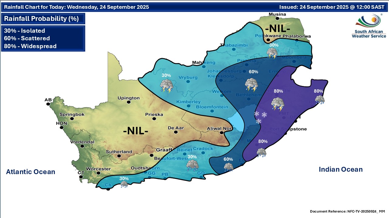
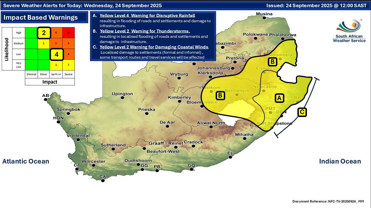
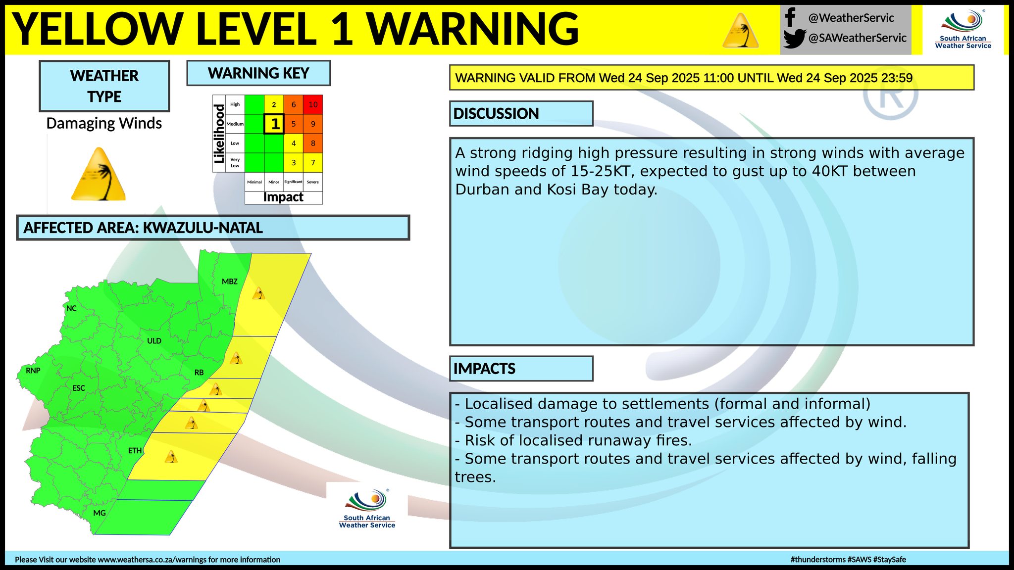
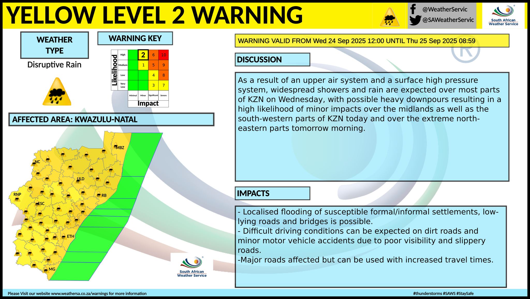
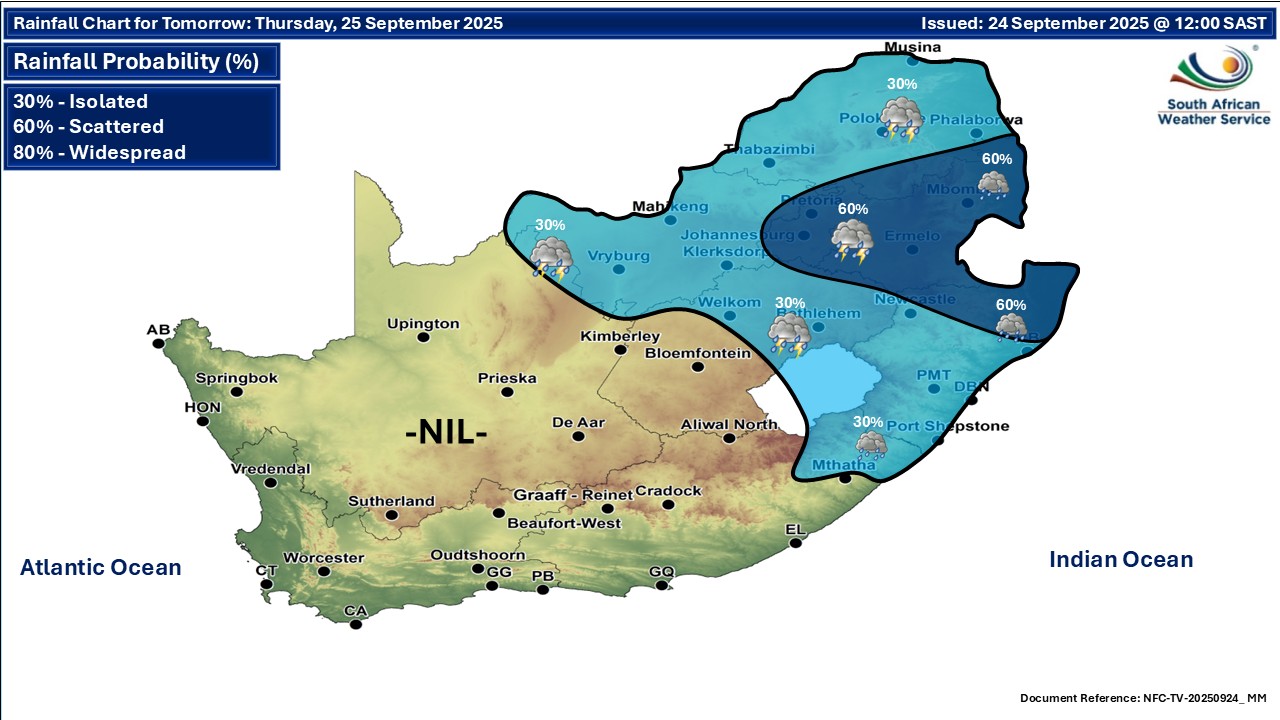
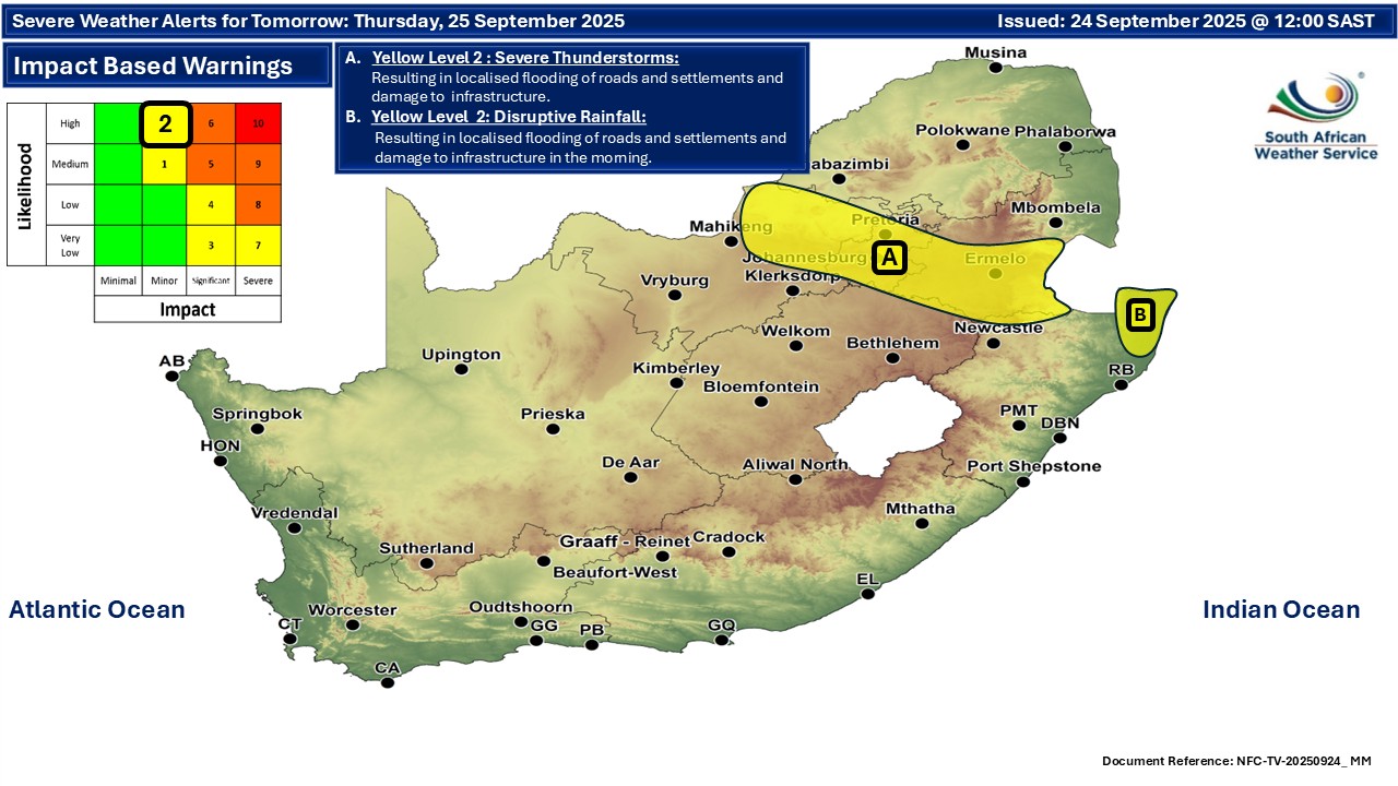
A newer forecast is available by clicking here. Widespread rainfall in the east on Wednesday and snowfall possible in the Drakensberg with major disruption of traffic and danger to life possible. Very cold conditions are expected in places over the eastern interior of the Eastern Cape on Wednesday and snow has fallen on the Drakensberg already, with more possible through the day. ALSO READ: More snowfall for Lesotho and South Africa on Wednesday. Warnings from the SA Weather Service for Wednesday: A. level 2 warning for disruptive rainfall with heavy downpours resulting in flooding of roads and settlements and damage to infrastructure is expected along the coast as well as over the northern parts of KwaZulu-Natal and the southern parts of Mpumalanga. Possible impacts include flooding of settlements, roads and bridges, damage to property and infrastructure, danger to life (fast flowing streams / deep water), displacement of affected communities, poor driving conditions and major disruption of traffic flow due to roads and bridges being closed or flooded. B. level 2 warning for severe thunderstorms with damaging winds, large amounts of small hail and heavy downpours resulting in localized flooding and damage to settlements, properties and roads are expected in place over Mpumalanga as well as the extreme south-eastern parts of Gauteng, the eastern parts of Free State as well as the Midlands and south-western parts of KwaZulu-Natal. C. level 2 warning damaging coastal winds with speeds of 15-25 knots, gusting up to 40 knots off the coast between Durban and Kosi Bay. Extremely high fire danger conditions are expected over the Kagisano-Molopo Municipality of the North West, as well as Gamagara Municipality of the Northern Cape. Warnings from the SA Weather Service for Thursday: A. level 2 warning for severe thunderstorms over parts of North West, as per the map below. B. level 2 warning for disruptive rainfall over parts of KwaZulu-Natal, as per the map below. Regional forecasts from the SA Weather Service for Wednesday: GAUTENG Partly cloudy and warm but hot in the extreme north, with scattered showers and thundershowers from the afternoon. The expected UVB sunburn index: High MPUMALANGA Cloudy in the east, otherwise partly cloudy and cool to warm with scattered showers and thundershowers but widespread along the escarpment in places in the Highveld and in places in the Highveld. LIMPOPO Partly cloudy and warm to hot with isolated to scattered showers and thundershowers in the south and central. NORTH-WEST Partly cloudy and warm to hot, with isolated showers and thundershowers, but scattered in the east. THE FREE STATE Partly cloudy and cool to warm with isolated showers and thundershowers except in the west but scattered in the east where it will be cloudy. THE NORTHERN CAPE Partly cloudy in the morning, otherwise fine and cold to cool but warm in the interior and eastern parts. It will become partly cloudy in the north-east with isolated showers and thundershowers. The wind along the coast will be fresh to strong south-easterly THE WESTERN CAPE Fine in the western parts, otherwise partly cloudy and cold to cool but warm in places over the West Coast with isolated rain and showers along the south coast and adjacent interior over the southern parts until the afternoon. The wind along the coast will be fresh to strong south-easterly to southerly but moderate along the south coast. The expected UVB sunburn index: High THE WESTERN HALF OF THE EASTERN CAPE Cloudy in the east, otherwise partly cloudy and cold, with isolated showers of rain. The wind along the coast will be moderate southerly to south-easterly. THE EASTERN HALF OF THE EASTERN CAPE Cloudy and cold with isolated showers and thundershowers but scattered along the coast and in the east. The wind along the coast will be Moderate to fresh south-westerly. KWAZULU-NATAL Cloudy and cool with widespread showers and thundershowers. The wind along the coast will be moderate northerly to north-easterly at first, otherwise fresh to strong southerly to south-westerly. The expected UVB sunburn index: Moderate Travellers forecasts from the SA Weather Service for Wednesday: PRETORIA Partly cloudy with scattered showers and thundershowers from the afternoon. Minimum/Maximum: 14/29°C The expected UVB Sunburn Index: High JOHANNESBURG Partly cloudy with scattered showers and thundershowers from the afternoon. Minimum/Maximum: 13/28°C VEREENIGING Partly cloudy with scattered showers and thundershowers from the afternoon. Minimum/Maximum: 13/27°C MBOMBELA Cloudy with widespread showers and thundershowers. Minimum/Maximum: 16/26°C POLOKWANE Partly cloudy with isolated showers and thundershowers. Minimum/Maximum: 11/29°C MAHIKENG Partly cloudy, with isolated showers and thundershowers Minimum/Maximum: 17/28°C VRYBURG Partly cloudy, with isolated showers and thundershowers Minimum/Maximum: 12/28°C BLOEMFONTEIN Partly cloudy, with isolated showers and thundershowers. Minimum/Maximum: 10/25°C KIMBERLEY Partly cloudy, with isolated showers and thundershowers. Minimum/Maximum: 9/25°C UPINGTON Fine. Minimum/Maximum: 9/27°C CAPE TOWN Partly cloudy, becoming fine from the afternoon. Wind: Moderate to fresh south-easterly. Minimum/Maximum: 11/18°C The expected UVB Sunburn Index: High GEORGE Cloudy with chances of rain until the afternoon, becoming partly cloudy in the evening. Wind: Light westerly to south-westerly, becoming light easterly from the evening. Minimum/Maximum: 11/16°C GQEBERHA Partly cloudy with isolated showers and rain. Wind: Moderate southerly to south-easterly. Minimum/Maximum: 13/17°C BARKLY EAST Clear in the day and partly cloudy later. Minimum/Maximum: 1/22°C EAST LONDON Mostly cloudy and cold with isolated showers and thundershowers but scattered in the east. Wind: Moderate to fresh south-westerly. Minimum/Maximum: 13/17°C DURBAN Cloudy with widespread showers and thundershowers. Wind: Light to moderate north-easterly in the early morning, otherwise moderate to fresh southerly to south-westerly. Minimum/Maximum: 14/20°C The expected UVB Sunburn Index: Moderate RICHARDS BAY Cloudy with widespread showers and thundershowers. Wind: Light to moderate north-easterly in the early morning, otherwise moderate to fresh southerly to south-westerly. Minimum/Maximum: 16/22°C PIETERMARITZBURG Cloudy with widespread showers and thundershowers. Minimum/Maximum: 12/17°C This forecast is usually updated a few times per day.
Please be sure to send photos and videos to us via whatsapp and also tell us where and when they were taken. Follow our channels
Maps for Thursday 25 September
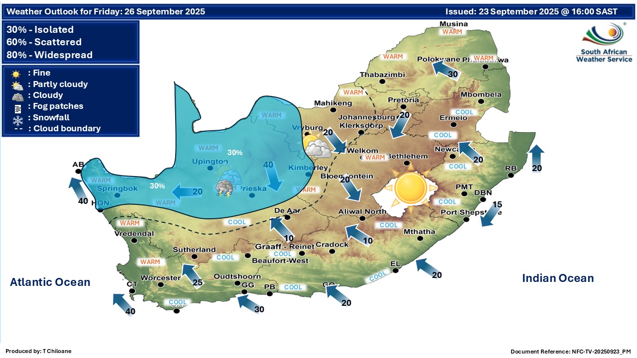
  Maps for Friday 26 September
|